Updated October 2026 · Jesse McGreevy and Marc Comisar, Domain Realty
Sellers and buyers in South Gulf Cove ask the same first question: what does the recorded county file say about this canal grid? McGreevy and Comisar answer it from Charlotte County's own sales files, fee schedules and flood maps, not from builder brochures.
South Gulf Cove is a General Development canal community of 11,887 parcels in Port Charlotte, Florida, where about 53 miles of canal reach the Myakka River and Charlotte Harbor through a single county lock. In the 12 months to September 9, 2026, the county recorded 327 home sales at a $480,000 median and 243 lot sales at a $25,000 median (Charlotte County Property Appraiser public roll and sales files, our analysis).
Sellers come first on this page. The market section shows how the county record reads for a South Gulf Cove seller, and the sections on the lock, the bridges, the fees and the flood zones cover what a buyer will ask about your home before an offer.
Why McGreevy and Comisar Are the Best Realtor for South Gulf Cove
If you're searching for the best realtor for South Gulf Cove, whether you're ready to sell your South Gulf Cove home or buy your next one, McGreevy and Comisar is the team that delivers. We lead Domain Realty Group, the #1 real estate team in Southwest Florida since 2012, Top 1% Nationally since 2008, with over $2.5 billion sold as a team and $900 million in personal sales between Jesse and Marc.
The South Gulf Cove market record (the 12 months to September 9, 2026, Charlotte County recorded sales): 327 home sales · median $480,000 · 109 builder-direct sales at a $380,000 median · 218 resales at a $560,000 median · highest recorded sale $1,860,000 · 243 recorded lot sales at a $25,000 median. Days on market and sale-to-list: Information not available at time of publishing (checked 2026-10-07). (Charlotte County Property Appraiser public roll and sales files, our analysis.)
For luxury South Gulf Cove sellers: Premium marketing, cinematic video, drone, professional photography, qualified-buyer database, discretion and off-market capability when needed.
Honors and recognition:
- Top 1% Real Estate Agents Nationally Since 2008
- 5 Star Award for Customer Satisfaction for 21 Straight Years. Only 5 out of 21k+ Licensees (Gulfshore Life Magazine)
- #1 Team in Southwest Florida since 2012
- McGreevy and Comisar and their Domain Realty Group team have sold over $2.5 Billion in Real Estate
- McGreevy and Comisar alone have over $900 million in Sales
- Nationally Recognized Top Producing Realtors
- Platinum Sales Production Award Winners
Selling your South Gulf Cove home? Get a free home valuation at https://mcgreevyandcomisar.com/home-valuation OR call Jesse direct at (239) 898-6072 (confidential conversations welcome for luxury listings). Our guide to selling a South Gulf Cove home sets out the listing plan, and our South Gulf Cove home valuation page shows how we price a home here.
Buying a home in South Gulf Cove? Call Marc at (239) 287-5873 for a personalized buyer consultation. Our guide to buying a home in South Gulf Cove covers the lot, the lock and the contract checks before an offer.
Sellers comparing the best real estate agents in Port Charlotte can start with the county record on this page. As the leaders of Domain Realty Group our team has closed over $2.5 billion in real estate. Jesse McGreevy and Marc Comisar have been Top 1% Real Estate Agents Nationally Since 2008, and the method we use to price a South Gulf Cove home is the method this page shows: the county's recorded sales first, the county's recorded charges second, and every unknown stated as unknown.
That method matters on a canal grid. Two South Gulf Cove homes a mile apart can sit in different plats, pay different county charges, reach the lock by different routes and read different flood zones on the federal map. A median for the whole community is a starting point, and the price of a particular home is set section by section, street by street and address by address. The sections below keep the county record, the association record and builder marketing apart so a buyer or a seller can see which is which.
Data updated: October 2026 (Charlotte County recorded sales through September 9, 2026).
Key Takeaways: What Should South Gulf Cove Buyers and Sellers Know?
South Gulf Cove buyers and sellers should know eight things: the size of the grid, the 12-month sales record, the lot market, the single lock, the bridge heights, the voluntary association, the county charges and the section-by-section flood picture. Each takeaway below is developed, with its source, in a later section of this page.
- South Gulf Cove is eight General Development plats in unincorporated Charlotte County with 11,887 parcels; 4,235 carry a year built, so most of the grid is still lots.
- In the 12 months to September 9, 2026, South Gulf Cove recorded 327 home sales at a $480,000 median; a third of them (109) were a builder's first sale of a new home.
- Recorded lot sales (vacant land) in the same window: 243 at a $25,000 median.
- One county lock connects about 53 miles of canal to the Myakka River and Charlotte Harbor. The waterway advisory board's minutes record that the County Commission cancelled a parallel lock, and a state-funded tender house is in design.
- The South Gulf Cove Homeowners Association publishes bridge heights between 8 feet and 9 feet 6 inches. Whether a given lot reaches the lock without a bridge is checked address by address.
- Membership in the South Gulf Cove Homeowners Association is voluntary at $120 a year, but the 2011 revitalized deed restrictions bind every lot in the eight sections.
- County charges on a typical South Gulf Cove home run about $825 to $1,125 a year before property tax.
- Flood zones differ by section: 9 of 11 sampled addresses read Zone AE at 8 feet NAVD88, two read Zone X, and Section 78 is about half Zone X by our overlay.
Data updated: October 2026 (Charlotte County recorded sales through September 9, 2026; county fee schedules for fiscal 2027; FEMA map effective December 15, 2022).
Table of Contents
This South Gulf Cove guide has 32 sections, from the county sales record and the lock to flood zones, fees and schools. Use the list below to find the section you need; sellers can start with the market record, and buyers can start with the lock, the bridges and the Fee Stack.
What Is It Like Living in South Gulf Cove as a Homebuyer?
Living in South Gulf Cove means owning on a General Development canal grid with lots the county's plan sizes from one-fifth to one-half acre, about 53 miles of canal behind one county lock, and a voluntary homeowners association. Most of the grid is still empty lots, so a South Gulf Cove street often mixes new homes and vacant parcels.
Data updated: October 2026 (Charlotte County Property Appraiser public roll as of October 4, 2026, and recorded sales through September 9, 2026; our analysis).
A buyer here is choosing a platted grid, not a master-planned neighborhood with one builder and one set of rules. The county's 2002 community plan describes eight sections "recorded in public records in 1960 and 1970" and a total area "in excess of 6,200 acres of land and water" (Charlotte County, South Gulf Cove Community Plan). What a buyer owns today depends on the section, the street, the lot and the water, and the sections that follow take those one at a time.
What kind of place is South Gulf Cove?
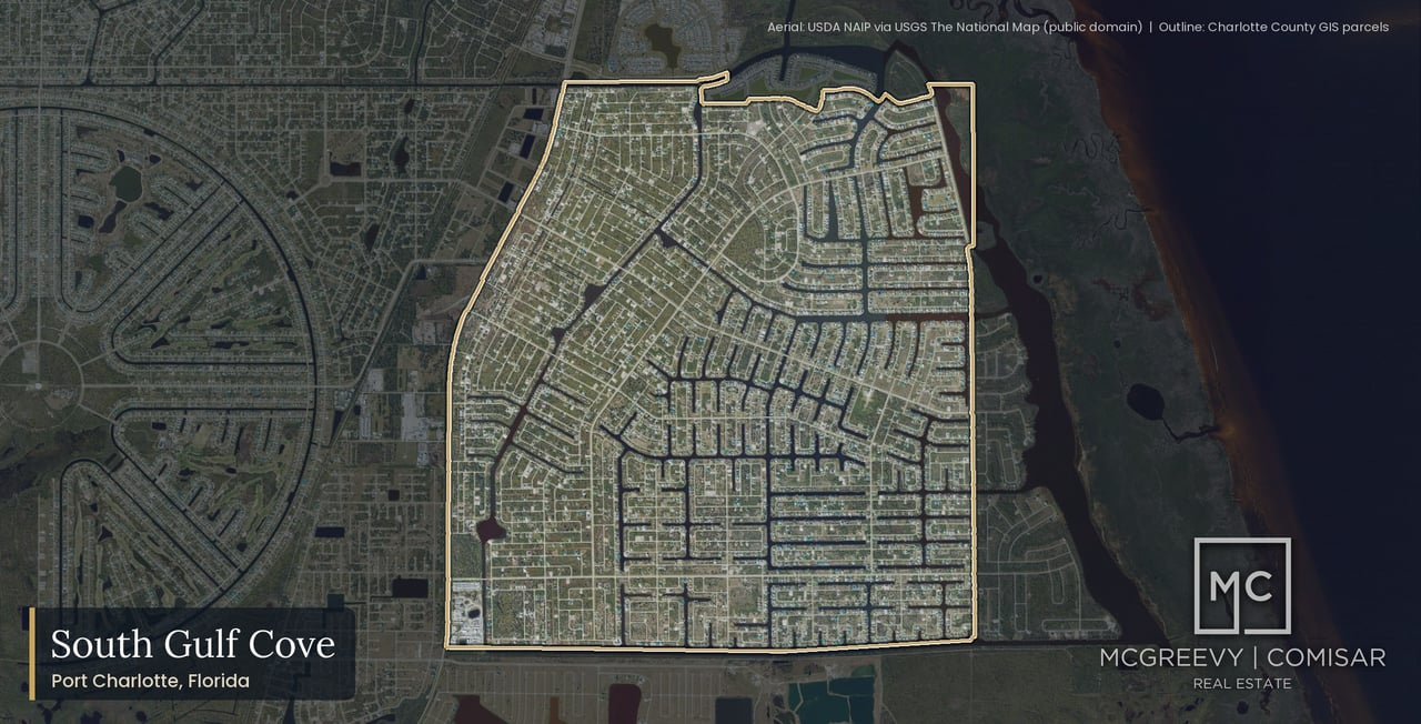
South Gulf Cove is a General Development platted grid of eight sections of the Port Charlotte Subdivision: Sections 58, 71, 78, 81, 82, 85, 87 and 93. It sits in unincorporated Charlotte County, and Port Charlotte is the mailing address (the ZIP is 33981). It is not a city, and it falls in no Census place.
The county's 2002 plan counted 15,053 deeded lots, 4,734 of them waterfront and 10,319 "dry lots." Today's county roll shows 11,887 parcels with a 33981 situs in the eight sections. We print both numbers with their dates and do not reconcile them, because the plan and the roll count different things in different years.
The roll sorts the grid by use: 6,747 parcels are coded vacant residential, 4,084 are single-family, 540 are vacant with a land improvement, 222 are vacant multifamily, 119 are duplexes and 111 are vacant commercial (Charlotte County Property Appraiser public roll, our analysis; the appraiser's land use codes define each code). A 400-parcel sample in each section puts the typical lot at about 10,000 square feet, which is also the minimum lot size in the county's RSF-3.5 zoning district.
Which Gulf Cove is which?
"Gulf Cove" names five different places around here, and mixing them up is the most common mistake in a South Gulf Cove search. This page covers the eight sections above, which share a voluntary homeowners association and one lock. The other four are separate places with separate records.
Gulf Cove, north of State Road 776, is a different set of plats with its own waterway unit. It is the natural comparison for a South Gulf Cove buyer, and we set the two side by side in a later section. Gardens of Gulf Cove and the Village of Holiday Lake are two more places that carry the name, each with its own records and its own association or rules.
Waterview in South Gulf Cove is Section 94, a separate plat with its own mandatory association. A dedicated Waterview page is in progress. Harbor East and Harbor West are next to South Gulf Cove, north of Section 93, on their own plats; Harbor East and Harbor West will each have their own page too. Builder marketing that says "Gulf Cove" can mean any of these places, so we resolve every address to its recorded section before we use it.
Where exactly is South Gulf Cove?
South Gulf Cove sits in the west region of unincorporated Charlotte County. The county's plan draws its planning boundaries as the Butterford Waterway on the north, the Interceptor Lagoon on the east, the Santa Cruz Waterway on the south and CR 771 (Gasparilla Road) on the west. The lagoon is county-owned.
The county's 2008 park plan adds a detail that shapes daily travel: the community has "only four access points, all from Gasparilla Road" (Charlotte County, South Gulf Cove Community Park System Master Plan). All eight sections are in county tax district 006. Drive times to the beach, the hospital and the interstate come later in this guide, measured from sample addresses.
What does the county roll show on the ground?
The roll shows a grid that is newer than most buyers expect. Of the 4,235 parcels with a year built, the roll lists 18 from the 1970s, 136 from the 1980s, 274 from the 1990s, 1,085 from the 2000s, 1,092 from the 2010s and 1,630 from the 2020s. The median year built is 2017. Single-family homes have a median of 2,090 square feet of county heated area, and 1,965 of them fall between 2,000 and 2,499 square feet.
Two strips are worth knowing. The roll lists 119 duplex parcels, 56 of them on Agate St, and 52 of those 56 were built in 2019 or later. And it lists 111 vacant commercial parcels, 68 on Winborough Dr and 30 on Wiltshire Dr. A buyer looking at a lot should check what the county zoning allows next door before assuming a quiet single-family block, and we take the zoning in a later section.
Is South Gulf Cove built out?
No. Of 11,887 parcels, 4,235 carry a year built, which is 35.6 percent, and 4,095 of those are single-family homes. The rest are lots, and a South Gulf Cove street can hold a newly built home beside a vacant parcel.
The pace is recent. The roll shows 418 parcels with a year built of 2023, 325 of 2024 and 314 of 2025. The county's 2002 plan counted "only about 600 homes, housing about 1,300 people" in January 2002 and said build-out could approximate 33,000 people. We print those as the plan's figures for 2002 and make no claim about today's population, because South Gulf Cove sits in no Census place and no current count exists for it.
What is life on a lock-controlled canal like?
Every canal in South Gulf Cove reaches the Myakka River and Charlotte Harbor through one county-owned lock at the turn basin in the Butterford Waterway. The South Gulf Cove Homeowners Association's FAQ dated September 1, 2026 lists tender hours of 7 a.m. to 7 p.m. daily, and says the lock can be operated manually after hours (South Gulf Cove HOA FAQ; the county's lock operating page describes the lock and its operating modes).
The same HOA FAQ puts bridge heights between 8 feet and 9 feet 6 inches, varying with water level and location, gives an average canal depth of 5 feet, and calls the canals "minimum wake" zones. That is what the association publishes, and it is a general statement, not a clearance for a particular boat at a particular dock. Port Charlotte Beach is the city's other gulf-access canal community, with 43 recorded sales at a $545,000 median in the same 12 months.
Living here also means living with the lock as a schedule. A boat leaving after hours depends on manual operation, and the county's advisory board minutes of June 3, 2026 record two lock tender positions open, with Public Works operators filling in. We cover the lock, the bridges and the canals in full later on this page.
Who builds new homes in South Gulf Cove today?
New construction here is a mix of national builders and local ones. The county's 2025 and 2026 sales files show it: 109 of the 327 recorded home sales in the 12 months to September 9, 2026 were a builder's first sale of a new home, and 93 of the 299 single-family sales were. On the county roll, Adams Homes holds at least 44 lots and West Pioneer at least 20 by owner-name count; those are floors, not totals, because builders also buy through other entities.
Lennar and Adams Homes both market in South Gulf Cove, as of marketing pages seen on October 10, 2026. We treat that marketing as marketing. The county's recorded sales set the medians on this page, and the builder prices we print later sit in their own labelled section, never beside a recorded median as its cause.
Is there golf, a club or a marina?
Not inside the grid. The records we read show no golf course, no marina and no club facility inside South Gulf Cove. The nearest golf is The Cove of Rotonda, an executive 18-hole course with lighted play, 3.25 straight-line miles from the HOA clubhouse; Riverwood Golf Club is 6.60 straight-line miles away.
What South Gulf Cove does have is the HOA clubhouse on Ingraham Blvd, which seats 215 and hosts a Sunday farmers market, monthly bingo and food trucks from October to May, and the South Gulf Cove Yacht Club, a social club with no clubhouse or docks of its own. A private dry-storage yard with a travel lift sits on Appleton Blvd in Section 85, and the Palm Harbour Marina fuel dock is 8.50 straight-line miles from the lock. Those details come back in the section on golf, marinas and clubs.
How do flood zones, schools and services fit daily life?
Flood is read address by address. The federal flood map at 11 sample addresses spread across the sections reads Zone AE at a base flood elevation of 8 feet NAVD88 at nine of them and Zone X at two (Santa Cruz Dr in Section 58 and Winnipeg St in Section 87). South Gulf Cove is never "in Zone AE" as a whole; a map zone is not a determination for a house.
Schools are the same at every sampled address: Myakka River Elementary, L. A. Ainger Middle and Lemon Bay High. Charlotte County Fire Rescue Station 4 on Marathon Blvd is the first-due station at all 11 sample points. There is no hospital, emergency room or urgent care inside the grid; the nearest 24-hour emergency rooms are 19 to 33 minutes away by car without traffic, depending on the origin and the hospital.
What are the rules, and is membership required?
Membership in the South Gulf Cove Homeowners Association is voluntary, at $120 a year in 2026. The deed restrictions are not voluntary. The Amended and Restated Declaration, recorded February 4, 2011 (Official Records Book 3545, Page 1467), was revitalized under Chapter 720, Part III of the Florida Statutes, and it runs on the lots in all eight sections (declaration copy on the HOA's site).
Among other things, the declaration limits each lot to one detached single-family home, prohibits manufactured and modular homes, requires at least 1,500 square feet of living area with an attached two-car garage, and caps height at three stories. Waterview, Section 94, is the exception worth knowing: it has its own mandatory association with a $90 assessment for 2026. Governance gets its own section later.
What do we walk a South Gulf Cove buyer through first?
We start with the address, because on this grid nearly every answer depends on it. A walk-through with a South Gulf Cove buyer covers, in this order:
- The section and plat, and what the county's recorded sales say about that section.
- The county charges on that parcel, from the county's MSBU record search, including the paving phase and whether the parcel is billed at the waterfront or the dry-lot waterway rate.
- The route from the dock to the lock and the bridges on it, checked for that address.
- The flood reading for that address, the lowest-floor height that follows from it, and the elevation documents available.
- The deed restrictions and the architectural review guidelines, including what is and is not reviewed.
- For a lot, the zoning, the scrub-jay and gopher tortoise rules, and whether the parcel is one of the roughly 9 new-home closings the county still codes as vacant land.
What Does the South Gulf Cove Market Look Like Right Now?
In the 12 months to September 9, 2026, South Gulf Cove recorded 327 home sales at a $480,000 median, ranging from $90,000 to $1,860,000, plus 243 recorded lot sales at a $25,000 median. A third of the home sales were a builder's first sale of a new home, which pulls the community median down.
Data updated: October 2026 (Charlotte County recorded sales through September 9, 2026).
Charlotte County recorded sales lead every figure in this section. Days on market, sale-to-list ratio and months of supply come from the multiple listing service, which we could not query for this page, and where a reader expects them we say so. Every figure below is from the Charlotte County Property Appraiser public roll and sales files, our analysis.
The county record, 12 months
All recorded home sales | 327 | $480,000 | $90,000 to $1,860,000 |
Single-family homes only | 299 | $490,000 | $230,000 to $1,860,000 |
Builder-direct (a builder's first sale of a new home) | 109 | $380,000 | |
Resale | 218 | $560,000 | |
Recorded lot sales (vacant land) | 243 | $25,000 | $10,000 to $845,000 |
The table covers the 12 months to September 9, 2026, Charlotte County recorded sales. The median price per square foot of county heated area is $235.14 for all home sales (n = 305) and $237.82 for single-family homes (n = 299). Price per square foot here uses the county's heated area and is never compared with a listing's living area.
The window matters less than the mix. Over longer windows the county file shows 548 sales at a $472,500 median in 24 months, 798 at $490,000 in 36 months and 1,216 at $481,350 in 60 months, so the $480,000 median is not a one-year accident.
Single-family homes only
Single-family homes are the cleanest reading of the home market. In the 12 months to September 9, 2026, South Gulf Cove recorded 299 single-family sales at a $490,000 median, from $230,000 to $1,860,000. Of those, 93 were builder-direct at $380,000 and 206 were resales at $569,500.
The all-sales low of $90,000 is not a home price. The 327 sales include 13 on parcels the roll codes as vacant residential land with a land improvement (median $135,000), 8 on parcels coded vacant residential and 1 on another vacant code, usually new homes the roll had not yet re-coded. Every sentence about what a home costs on this page uses the single-family figures for that reason.
Builder-direct versus resale
A builder-direct sale is a builder's first sale of a new home, and it behaves differently from a resale. In the 12 months to September 9, 2026, South Gulf Cove had 109 builder-direct sales at a $380,000 median and 218 resales at a $560,000 median. The two medians describe two different products, not one market at two prices.
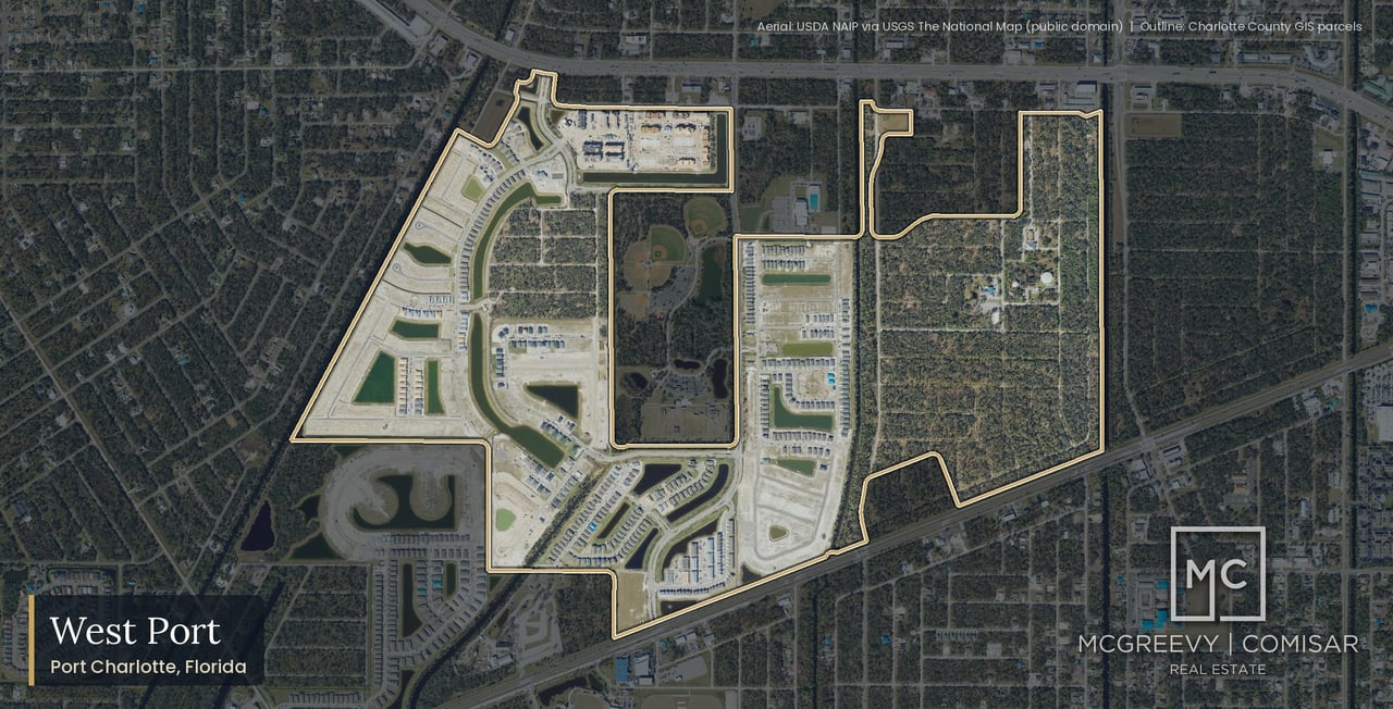
Read the two medians against the product you are comparing. For a master-planned alternative built mostly by one developer, West Port recorded 180 sales at a $290,000 median in the same window.
Price bands
Under $200,000 | 12 |
$200,000 to $299,999 | 15 |
$300,000 to $399,999 | 77 |
$400,000 to $499,999 | 70 |
$500,000 to $749,999 | 117 |
$750,000 to $999,999 | 30 |
$1,000,000 and up | 6 |
The largest band is $500,000 to $749,999, with 117 of the 327 sales, and 147 sales fall between $300,000 and $499,999. Only 6 sales reached $1,000,000, and the highest recorded sale was $1,860,000.
Calendar years since 2019
2019 | 228 | $310,500 | 63 |
2020 | 308 | $330,000 | 101 |
2021 | 280 | $465,650 | 70 |
2022 | 177 | $475,000 | 81 |
2023 | 236 | $485,850 | 138 |
2024 | 230 | $515,000 | 102 |
2025 | 264 | $475,000 | 113 |
2026 to September 9 | 229 | $485,000 | 60 |
The median rose from $310,500 in 2019 to $515,000 in 2024, then read $475,000 in 2025 and $485,000 for 2026 through September 9. The builder-direct count peaked at 138 in 2023. These are recorded medians, not forecasts, and a median moves when the mix of sections, ages and builder-direct sales moves.
Section by section
Port Charlotte Subdivision Section 58 | 2,201 (695) | 50 | $410,000 | 22 | 28 | $210.48 |
Port Charlotte Subdivision Section 71 | 981 (417) | 30 | $458,350 | 9 | 21 | $217.77 |
Port Charlotte Subdivision Section 78 | 829 (233) | 25 | $425,000 | 15 | 10 | $189.96 |
Port Charlotte Subdivision Section 81 | 1,465 (641) | 52 | $487,500 | 14 | 38 | $241.17 |
Port Charlotte Subdivision Section 82 | 1,378 (594) | 35 | $595,000 | 6 | 29 | $275.03 |
Port Charlotte Subdivision Section 85 | 1,078 (264) | 22 | $341,150 | 15 | 7 | $170.04 |
Port Charlotte Subdivision Section 87 | 1,614 (453) | 37 | $499,900 | 15 | 22 | $232.63 |
Port Charlotte Subdivision Section 93 | 2,341 (938) | 76 | $582,500 | 13 | 63 | $281.09 |
The sections split into three tiers. Section 93 (76 sales at $582,500) and Section 82 (35 at $595,000) carry the highest medians and are mostly resale. Section 85 (22 at $341,150) and Section 78 (25 at $425,000) sit at the other end, with builder-direct sales making up most of their records. Sections 71, 81 and 87 fall between $458,350 and $499,900, and Section 58 at $410,000 sits closer to the lower tier. Per square foot, county heated area, the range runs from $170.04 in Section 85 to $281.09 in Section 93.
South Gulf Cove's median price per square foot of county heated area is $235.14 for all home sales in the 12 months to September 9, 2026 (n = 305), and $237.82 for single-family sales (n = 299). The section figures above show the spread, from $170.04 to $281.09.
Use the figure to compare sections of South Gulf Cove with each other, and with other communities that we measure the same way. Do not compare it with the living-area square footage on a listing, which is measured differently and can include or exclude space the county counts. The benchmark section later in this guide sets South Gulf Cove beside Gulf Cove, Port Charlotte Beach and West Port on the same county method.
The lot market
Vacant lots are a market of their own here, with 243 recorded lot sales (vacant land) in the 12 months to September 9, 2026, at a $25,000 median and a range of $10,000 to $845,000. Over longer windows the county file shows 469 lot sales at $25,200 in 24 months, 933 at $28,000 in 36 months and 2,234 at $30,000 in 60 months.
2019 | 259 | $11,000 |
2020 | 445 | $12,000 |
2021 | 1,382 | $23,900 |
2022 | 789 | $32,500 |
2023 | 411 | $30,000 |
2024 | 415 | $30,000 |
2025 | 200 | $26,000 |
2026 to September 9 | 186 | $22,500 |
By section, the 12-month lot counts and medians are Section 87, 42 at $25,000; Section 58, 39 at $21,000; Section 81, 38 at $30,000; Section 93, 34 at $27,050; Section 85, 30 at $20,200; Section 82, 24 at $43,000; Section 71, 21 at $30,000; and Section 78, 15 at $19,000. The 2021 count of 1,382 lot sales is the peak, and the 2026 pace through September 9 is 186.
A recorded lot price is not a build price. The median lot sale ($25,000) and the median builder-direct home sale ($380,000) are two recorded numbers; the difference between them is the house, the site work and the fees, which the county record does not split, so we do not add them up.
New homes the county still codes as lots
The county codes a parcel by what stood on it when the roll was set, so a new home closed before the house reached the roll still reads as vacant land. About 9 further closings above $150,000 in the 12 months to September 9, 2026 are coded as vacant land in the county file because the home was not yet on the roll; they are not in the improved-sale count.
They sit inside the 243 recorded lot sales (vacant land) and in no home median on this page. We list them separately so a seller of a very new home, or a buyer comparing a new home to the recorded sales, knows the record can lag a finished house.
Builder marketing prices, seen October 10, 2026
Builder prices are marketing, not records. On October 10, 2026, Lennar's marketing for South Gulf Cove showed its Bloom plan, 1,487 square feet, from $286,999, and its Celeste plan, 1,824 square feet, from $304,999. Adams Homes showed eight move-in-ready listings at $362,300 to $544,450.
These are advertised starting prices and asking prices on builders' own pages on that date. They are not sales, they exclude whatever a buyer adds in options, lot premiums and closing costs, and we do not set them beside a recorded median as its explanation. The recorded builder-direct median is $380,000 for the 12 months to September 9, 2026; the advertised starting prices are a different kind of number.
Days on market and sale-to-list
Information not available at time of publishing (checked 2026-10-07).
Days on market, sale-to-list ratio and months of supply come from the multiple listing service, which we could not query when this page was built. We do not estimate them. A seller who wants to know how long a South Gulf Cove home takes to sell in a given price band and section should ask us for the multiple listing service pull for that segment, which we run for each valuation.
Canal-front versus off-water homes
Information not available at time of publishing (checked 2026-10-07).
The canal-front versus off-water price split was not measured for this page. Canal-front homes carry a higher county waterway charge ($50 a year against $25 for an off-water home in fiscal 2027), and sales on the water sit toward the upper end of the range, but how much a canal position adds in a given section, size and age is a comparison we make home by home, using recorded sales on the same street.
How should a seller read these numbers?
Read the section first, the product second and the window third. A South Gulf Cove home in Section 93 or Section 82 is being compared with a resale record at $582,500 to $595,000; a home in Section 85 or Section 78 is being compared with a record dominated by builder-direct sales at $341,150 to $425,000. The community median of $480,000 describes neither.
Then separate your home from the builder-direct sales. If your home is a resale, the $560,000 resale median ($569,500 for single-family) is the closer reference; if it is newer and competes with a builder's inventory, the $380,000 builder-direct median and the advertised builder prices set the competition. A buyer will also check the charges, the lock, the bridges and the flood reading for your address, and a home priced with those answers in hand sells on a firmer footing.
We build that comparison for every South Gulf Cove seller from the county's recorded sales on your street and in your section. To see what your home is worth on the recorded record, request a free home valuation or call Jesse direct at (239) 898-6072.
How Did South Gulf Cove Get Started?
South Gulf Cove started as a General Development Corporation canal subdivision: eight plats of the Port Charlotte Subdivision, recorded in 1960 and 1970, covering more than 6,200 acres of land and water in unincorporated Charlotte County. Building was slow for decades, and today most of the grid is still vacant lots.
Data updated: October 2026 (Charlotte County recorded sales through September 9, 2026).
The history of South Gulf Cove is easiest to read in three layers: what the county's own community plan says about how the grid was designed, what the recorded documents say about who held the land, and what the county roll shows about when homes were actually built. Each layer below is kept apart, and where a public record does not answer a question, the page says so.
General Development's canal grid
The county's South Gulf Cove Community Plan (revised July 11, 2002) describes the community as "eight sections recorded in public records in 1960 and 1970 with a total area in excess of 6,200 acres of land and water" (Charlotte County, South Gulf Cove Community Plan). The eight sections are Port Charlotte Subdivision Sections 58, 71, 78, 81, 82, 85, 87 and 93. The plan does not say which section was recorded in which year, and this page prints no per-section recording date because the sources we read do not state one; the plat sheets at the Clerk of Court hold them.
The plan draws the planning area with the Butterford Waterway to the north, the Interceptor Lagoon to the east, the Santa Cruz Waterway to the south and CR 771 (Gasparilla Rd) to the west, and says the lagoon is owned by the County. The county's 2008 community park system master plan describes the same area as having "only four access points, all from Gasparilla Road" (Charlotte County, South Gulf Cove Community Park System Master Plan, 2008).
Two lot counts are on the public record, and they measure different things. The 2002 plan counted 15,053 deeded lots, of which 4,734 were waterfront and 10,319 were "dry lots" with no direct access to the canal system. Today's county roll shows 11,887 parcels in the eight sections (Charlotte County Property Appraiser public roll and sales files, our analysis). We print both, each with its year, and do not reconcile them.
The plan says most lots "range in size from one-fifth to one-half acre." A 400-parcel sample per section on the county parcel layer puts the typical lot at about 10,000 square feet, the RSF-3.5 minimum (our analysis); the sample medians run from 10,192 square feet in Section 87 to 10,254 in Section 82. Port Charlotte is the mailing address. South Gulf Cove itself is unincorporated Charlotte County in tax district 006, and no Census place covers it.
Why the canals end in a lagoon and a lock
The county plan explains the water design in its own words. South Gulf Cove "was designed and filled primarily to provide upland developable land with rapid, uninterrupted drainage to the canal system to avoid flooding." The canal "fingers" are "dead-ended and particularly subject to stagnation," and the plan notes there are "no curbs or gutters and no major water retention or detention infrastructure" in the community other than the lagoon. The plan says the Interceptor Lagoon was built under a state and federal requirement for, among other purposes, final water-quality treatment of the community's runoff, and that a dam on the Butterford canal has since been installed to divert water from west of CR 771 through the canals, giving it more time in the system and flushing the canals (Charlotte County, South Gulf Cove Community Plan).
That is the origin of the arrangement a buyer sees today: a canal network that drains to a county-owned lagoon, with one county-owned lock at the South Gulf Cove Turn Basin in the Butterford Waterway (Charlotte County, South Gulf Cove boat lock). The year the lock was built, who built it, and the original permit or consent order behind the lagoon and the control structure were not found in any public record we read, so this page states no construction date.
The 2002 plan asked the community to identify a funding source for an additional lock "when needed." A parallel lock was later designed and then cancelled: the Waterway MSBU advisory board minutes of December 17, 2025 record that the Commission "decided to cancel work on the parallel lock" (Charlotte County, advisory board minutes, December 17, 2025). South Gulf Cove has one lock. The lock section later on this page covers hours, operation and the tender house.
From General Development to Atlantic Gulf Communities
The recorded paper shows how the grid passed from its developer to the county and to the homeowners association. The county's Recreation and Open Space Element records two transfers: a 1992 settlement with General Development Corporation, under which lands were offered to the county "in lieu of back-taxes owed on GDC owned property," and a 1994 donation from Atlantic Gulf Communities of 45 parcels totaling 170.48 acres, offered with a reverter if the county uses them for anything other than recreation or open space (Charlotte County, Recreation and Open Space Element). The county parcel layer today lists 21 "Future Potential Park" parcels, most of them from that 1994 donation.
On the homeowners side, the association's own history page records that in May 1994 Atlantic Gulf Communities assigned the South Gulf Cove Homeowners Association the right to enforce the deed restrictions (South Gulf Cove HOA, Association History). The recorded 2011 declaration says the association "is the successor in interest to Atlantic Gulf Communities Corporation, the successor to General Development Corporation, as the declarant." We publish the dated documents and nothing beyond them about the developer's later history.
Water and sewer set the pace
Utilities, not platting, decided when South Gulf Cove could be built. The county plan states that lots may only be developed after water and sewer services become available from the County, and in January 2002 the plan counted "only about 600 homes, housing about 1,300 people" while projecting that build-out could reach about 33,000 people (Charlotte County, South Gulf Cove Community Plan). The homeowners association's history page counts 80 homes in 1986.
The roll bears that out. The first large decade of construction on the roll is the 2000s, which fits the plan's 2002 statement that "building is accelerating." A buyer should read the 2002 build-out projection as a planning ceiling from that year, not a forecast; the plan's population figure is not a current population, and this page prints no current population for South Gulf Cove because none has been measured.
Build-out by decade
The county roll shows the following parcels by year built in the eight sections. These counts come from our reading of the roll (roll dated October 4, 2026) and are labelled as such.
1970s | 18 |
1980s | 136 |
1990s | 274 |
2000s | 1,085 |
2010s | 1,092 |
2020s | 1,630 |
Source: Charlotte County Property Appraiser public roll and sales files, our analysis.
Of the 11,887 parcels, 4,235 carry a year built (35.6 percent), and 4,095 of the built parcels are single-family homes. The median year built is 2017, so South Gulf Cove is a young community by Southwest Florida standards even though its plats are more than half a century old. By section, the mean year built is 2018 in Sections 58 and 85, 2017 in Section 78, 2015 in Sections 87 and 93, 2011 in Section 82, 2010 in Section 71 and 2007 in Section 81, the oldest-built section on the roll.
The 2020s building wave
By year built, the roll shows 418 parcels in 2023, 325 in 2024 and 314 in 2025, inside a decade total of 1,630 parcels built in the 2020s. The roll lags new construction, so a house finished this month can still be coded as vacant land; the most recent months are undercounted on the roll, and about 9 further closings above $150,000 in the 12 months to September 9, 2026 are coded as vacant land because the home was not yet on the roll. They are not in the improved-sale count.
The 2020s wave is visible in the sales record as builder-direct sales, a builder's first sale of a new home. In the 12 months to September 9, 2026, the sections with the most builder-direct sales relative to all sales were Section 58 (22 of 50), Section 78 (15 of 25), Section 85 (15 of 22) and Section 87 (15 of 37). The section-by-section module later on this page gives every section's figures. For a buyer, the practical meaning is that one street can hold finished homes, homes under construction and empty lots side by side, and that the neighbor's lot is worth checking before a contract.
What Was Planned for South Gulf Cove, and What Does the County Allow Today?
South Gulf Cove was planned by its property owners in a 2002 county community plan, but the county zoning map today shows RSF-3.5 single-family zoning throughout, with pockets of multifamily and general commercial zoning in seven of the eight sections. None of the plan's proposed new districts appears on the zoning layer.
Data updated: October 2026 (Charlotte County recorded sales through September 9, 2026).
A planning document and a zoning map answer different questions. The plan records what residents asked for; the zoning layer records what the county will permit on a parcel today. Before relying on either for a specific lot, read the zoning and future land use on the county's parcel record for that address.
The South Gulf Cove Community Plan (revised July 11, 2002, "per SGC HOA meeting of 7/8/02") states that its policies are the South Gulf Cove property owners' recommendations to the Board of County Commissioners (Charlotte County, South Gulf Cove Community Plan). It asks for new future land use and zoning designations, a park system, public-safety improvements and a study of an additional lock, a marina site in Section 97, and beautification of CR 771. The county lists the plan among its completed community plans (Charlotte County, Community Planning).
The plan has not been adopted into zoning. The county zoning layer carries none of the plan's proposed districts (the neighborhood and commercial mixed-use categories it names), and we found no adopting ordinance. The 2002 plan records property owners' recommendations; none of its proposed zoning districts appears on the county zoning layer. An advisory committee was established under Resolution 2003-072 and is inactive since its 2013 sunset recommendation (Charlotte County, South Gulf Cove Community Plan Advisory Committee).
Zoning on the county map
The county parcel layer, read October 10, 2026, shows these zoning districts in the eight sections:
Section 58 | RSF-3.5, RMF10, RMF12, RMF5, CG |
Section 71 | RSF-3.5, RMF15, CG |
Section 78 | RSF-3.5, RMF10, CG |
Section 81 | RSF-3.5, CG |
Section 82 | RSF-3.5 |
Section 85 | RSF-3.5, RMF10, CG |
Section 87 | RSF-3.5, RMF10, CG |
Section 93 | RSF-3.5, CG |
Harbor East and Harbor West (next to South Gulf Cove) | RMF-3.5 |
RSF-3.5 is the single-family district that covers the great majority of lots. RMF is residential multifamily, and CG is general commercial. The layer shows a mix of these districts but does not by itself say what stands on each parcel; the county roll does, and the next two sections use it.
What RSF-3.5 allows
Under the county's zoning code, RSF-3.5 requires a minimum lot of 10,000 square feet and 80 feet of width, a 25 foot front yard, a 7.5 foot interior side yard, building coverage of no more than 35 percent and a maximum height of 38 feet (Charlotte County, Most Commonly Used Zoning Code Sections). The permitted principal use is a single-family dwelling, excluding mobile homes. The county excerpt also lists nonprofit parks and playgrounds, family day care homes in an occupied single-family residence, one-student-at-a-time art and music instruction, and accessory private garage and storage structures.
The typical lot on the county parcel layer, about 10,000 square feet, sits right at that minimum, which is why a lot that looks generous on a map is often a minimum-size lot under the code. The text of the RMF and CG districts was not retrieved for this page, so we state no use or density rule for them.
Duplex blocks on Agate St
The county roll codes 119 parcels in the eight sections as duplexes, two units each by the Property Appraiser's land use code list (Charlotte County Property Appraiser, land use codes). Of those, 56 are on Agate St, and 52 of the 56 carry a year built of 2019 or later (county roll, our analysis). Agate St carries a strip of duplexes, most built since 2019.
The duplex parcels sit on the multifamily-zoned blocks listed above. For a buyer or an investor, the point is that South Gulf Cove is not only single-family: duplex product exists and is recent. Recorded home sales in the use-code breakdown for the 12 months to September 9, 2026 include 6 duplex sales at a $462,500 median, a small sample.
Commercial land on Winborough Dr and Wiltshire Dr
The roll lists 111 vacant commercial parcels in the eight sections: 68 on Winborough Dr and 30 on Wiltshire Dr, with the rest scattered along other streets. No vacant commercial parcel carries a year built. General commercial zoning appears in seven of the eight sections.
The 2002 plan expected small-scale commercial along the CR 771 corridor and a community commercial center on Calumet Blvd. Neither is confirmed built in the records read for this page. Current site plans on Wiltshire Dr are covered in the building and development section below.
Vacated Section 97 and the 2005 rezoning
Section 97 of the Port Charlotte Subdivision was platted and later vacated. The county plan says no individual lots are shown except one waterfront park site, that the whole section is designated for low-density residential use, and that "There are no deed restrictions in section 97" (Charlotte County, South Gulf Cove Community Plan).
County Ordinance 2005-068, petition Z-05-06-49, adopted August 23, 2005, rezoned 130.65 acres of vacated Section 97 blocks south of the Butterford Waterway from RSF-3.5 to RMF-3.5 for Lennar Communities, Inc. (Charlotte County, Ordinance 2005-068). The county zoning layer ties both the Harbor East and Harbor West plats to that petition, the 2005 rezoning of vacated Port Charlotte Subdivision Section 97 land south of the Butterford Waterway. That is the documented link between the two Harbor plats and the General Development grid; the Harbor plats are separate plats with their own associations, covered below.
Buying in South Gulf Cove? Start With Marc
South Gulf Cove recorded 327 home sales in the 12 months to September 9, 2026, and every one of those buyers faced the same section-by-section questions about the lock, the charges and the flood zone. Marc Comisar, with Jesse McGreevy one of the Top 1% Real Estate Agents Nationally Since 2008, walks South Gulf Cove buyers through them before an offer, with the county's documents on the table.
Call Marc at (239) 287-5873, or see how we represent buyers from the first showing to the closing table. For the wider city, our guide to buying a home in Port Charlotte covers the steps that apply on every Port Charlotte street.
★★★★★ "Marc and Jesse are truly great people and they care about the people that they work with. Marc made our house purchase seamless and we closed within 30 days. If you want someone that's gonna treat you like family, well you found them." Verified Google review
How Is South Gulf Cove Governed?
South Gulf Cove has one voluntary homeowners association, $120 a year, but its 2011 revitalized deed restrictions run with every lot in the eight sections whether or not an owner joins. Waterview has its own mandatory association, and Harbor East and Harbor West sit outside the South Gulf Cove HOA's section list.
Data updated: October 2026 (Charlotte County recorded sales through September 9, 2026).
There is no city government and no community development district here. Governance in South Gulf Cove is three things at once: the recorded deed restrictions, the voluntary association that enforces them, and the county's assessment districts, which the cost section below covers line by line.
A voluntary HOA with restrictions on every lot
The South Gulf Cove Homeowners Association, Inc. (state document 762005) was filed on February 16, 1982, is active, and filed its 2026 annual report on February 19, 2026 (Florida Division of Corporations, Sunbiz). Its clubhouse is on Ingraham Blvd. The bylaws state that "Membership is voluntary for those who choose to join the Association" (South Gulf Cove HOA, Bylaws), and the association's estoppel page calls itself "the only HOA in SGC" (South Gulf Cove HOA, estoppels).
Dues are $120 a year in 2026, payable by January 1, with one vote per membership regardless of how many lots an owner holds (South Gulf Cove HOA, membership). The association's history page records its first meeting on November 17, 1978 and articles approved in February 1982. Voting rights were opened to all property owners in 2005.
South Gulf Cove's deed restrictions were revitalized in 2011 under Chapter 720, Part III, Florida Statutes, and run with every lot in the eight sections whether or not the owner joins the HOA.
The 2011 revitalized declaration
The Amended and Restated Declaration was recorded on February 4, 2011 in Official Records Book 3545, page 1467, with the Notice of Covenant Revitalization at page 1731 and the state's approval dated January 25, 2011 (file DCA11-HA-011) (South Gulf Cove HOA, recorded declaration; Notice of Covenant Revitalization with state approval). It restated the original General Development declarations, which had been recorded section by section; where a prior declaration is more restrictive on a point such as voting or amendment, the prior declaration controls for that lot.
The restrictions run for 30 years from recording, to February 2041, then renew in 10-year periods unless changed. The association and any owner may enforce them, and the association is not obligated to enforce.
How the restrictions can be amended
Amendment follows the rules of the original General Development declarations, a condition of the state's 2011 approval. The state approved the revived declaration on the condition that the amendment provisions of the previous nine separate section declarations be substituted for the amendment article printed in the 2011 document. We did not read the text of those nine original amendment clauses, so this page states no vote threshold. A buyer who wants to know what it would take to change the rules for a given lot reads the recorded declaration for that section and the state's condition together.
What the declaration requires of a home
The declaration's use rules for residential lots are:
- Residential use only, one detached single-family home per lot.
- Manufactured, modular and similar homes are prohibited.
- A minimum of 1,500 square feet of living area with an attached two-car garage.
- No more than three stories.
- For multifamily units, at least 1,000 square feet per unit with a garage.
Waterview, governed by a separate declaration, sets its own minimum: 2,000 square feet under air under its current guidelines (Waterview Property Owners' Association, 2025 Restated Declaration).
Architectural review and its fees
The association's Residential ARC Guidelines (architectural review) were revised on March 25, 2026 and recorded on March 26, 2026 as Instrument 3627173 (South Gulf Cove HOA, Residential ARC Guidelines). The recorded fee schedule is:
New home | $250 |
Square footage change | $100 |
Garage or accessory building | $100 |
Fence | $50 |
Driveway | $50 |
Paint | $0 |
Contractor Clean Site Program | $1,000 |
The guidelines also set roofs at shingle, tile or metal with a 5/12 minimum pitch and a 38 foot height limit measured from the lowest minimum habitable floor elevation.
Fences, sheds, pools, docks and seawalls
Fences must not stand forward of the house, and between a structure and a waterway a fence is limited to 4 feet and must be see-through within 20 feet of the waterway, so as not to block neighbors' views of the canal. Sheds and accessory structures need a county permit and association approval; a larger accessory structure placed on an adjoining lot requires a recorded restrictive covenant that keeps the two lots together while the structure stands (South Gulf Cove HOA, covenant form).
The association's ARC page says in-ground pools, docks, seawalls and roof replacement do not require ARC review (South Gulf Cove HOA, forms). The recorded declaration's definition of an Improvement includes docks and seawalls, so a buyer reads both. County, state and federal permits for docks and seawalls apply either way and are covered in the canal section below.
Boats, trailers, RVs and rentals
In the eight sections the HOA refers owners to county code for boats, trailers and RVs; the county rule was not read for this page. On rentals, the HOA's FAQ states: "There are no rental restrictions, but the property must not become a nuisance, and the tenants must comply with noise, parking and all other local ordinances" (South Gulf Cove HOA, FAQ). County and state rules on short-term rentals were not read for this page.
Waterview is different. Its 2025 Restated Declaration prohibits short-term and transient rentals "to the fullest extent permitted by law" and allows one RV, trailer or boat in a driveway.
Estoppel when you sell
The South Gulf Cove HOA does not require an estoppel letter for a sale, though title companies often ask for one. The fee is $50 for the normal turnaround of 7 to 10 days or $75 expedited, plus a $29 portal fee (South Gulf Cove HOA, estoppels). The estoppel page routes Waterview requests to the Waterview association.
What HOA membership buys
Membership buys a vote at the monthly general meeting (third Wednesday at 7 pm at the clubhouse, except July and August), access to the members-only website with financials, member directory and minutes, and free classified advertisements; all residents may attend meetings (South Gulf Cove HOA, membership; FAQ).
The association's clubhouse seats 215 with a 150-car lot, and the welcome booklet lists food trucks from October to May, a Sunday farmers market, monthly bingo and a U.S. Coast Guard Auxiliary flotilla. The association bought its 14-acre Ingraham Blvd parcel in November 1999 and opened the pavilion in September 2003.
Waterview's mandatory association
Waterview is governed by its own mandatory association and its 2025 Restated Declaration. The Waterview Property Owners' Association, Inc. (state document 758604) was filed on June 3, 1981 and is active (Florida Division of Corporations, Sunbiz). Its 2026 assessment is $90, due January 1, 2026 (Waterview POA, 2026 annual meeting packet).
The 2025 Restated Declaration was recorded on May 19, 2025 (Instrument 3528305). It limits Waterview to single-family use and sets the 2,000 square foot minimum noted above. The association's fee sheet lists a new-home architectural fee of $300 and a dock license agreement fee of $350, and docks on common property need a license agreement and permits.
What Does It Cost to Own a Home in South Gulf Cove?
Owning a home in South Gulf Cove carries about $825 to $1,125 a year in county charges before property tax, depending on the paving phase and canal frontage, plus an optional $120 HOA membership. No community development district and no mandatory association apply in the eight sections.
Data updated: October 2026 (Charlotte County recorded sales through September 9, 2026).
The figures below are the county's fiscal 2027 rates, which appear on the November 2026 tax bill, for one platted lot of 0.23 acre. They come from the county's MSBU (municipal service benefit unit) records and the Florida Department of Revenue's district millage list, read October 10, 2026. Each rate is per equivalent residential unit (ERU) unless noted.
The Fee Stack
South Gulf Cove HOA (voluntary) | $120 if the owner joins | $120 if the owner joins | $120 if the owner joins | Voting membership, members' site, clubhouse programs | Year | HOA membership |
Fire Rescue MSBU | $294.90 | $294.90 | $125.61 | Countywide fire and rescue | Year | Residential, vacant |
Sanitation MSBU | $335.51 | $335.51 | $0 | Solid waste collection | Year | Sanitation |
South Gulf Cove street and drainage maintenance | $119.00 | $119.00 | $119.00 | Streets, drainage, bridge maintenance loan | Year | Occupied, vacant |
South Gulf Cove paving capital | $300.00 (Phases 2 to 5) or $0 (Phase 1/1A) | Same | Same | Resurfacing loan, 15 years | Year | Phase 1/1A, 2, 3, 4, 5 |
South Gulf Cove sidewalk capital | $2.03 | $2.03 | $2.03 | About 15 miles of pathways | Year | Sidewalks |
South Gulf Cove Waterway Benefit Unit | $50.00 | $25.00 | $50.00 canal or $25.00 dry | Lock operation, dredging, canal repair, lagoon cattails | Year | Waterfront, dry lot |
West Charlotte Stormwater | $23.71 (0.23 acre at $103.10) | $23.71 | $23.71 | Primary drainage and water quality | Year | Stormwater |
Total county non-ad valorem | $1,125.15 or $825.15 | $1,100.15 or $800.15 | $620.35 or $320.35 (canal); $595.35 or $295.35 (dry) | Sum of the rows above, without the HOA | Year | Computed from the rows above |
Property tax, district 006 | 15.2833 mills (2025) on taxable value | Same | Same | County, public safety, lighting, Stump Pass, schools, regional water | Year | Florida Department of Revenue |
Community development district | None | None | None | Not applicable | Not applicable | Florida Department of Revenue |
Mandatory association | None in the eight sections | None | None | Not applicable | Not applicable | HOA estoppels page |
Estoppel when you sell | Not required by the HOA; $50 or $75 plus $29 if a title company orders one | Same | Same | Resale certificate | At sale | HOA estoppels page |
How to read the Fee Stack
Every dollar figure in the table is a county or association rate, not an estimate. Three variables move a bill: whether the parcel sits in a Phase 1/1A paving area (no paving charge in fiscal 2027) or in Phases 2 to 5 ($300), whether the county classes the parcel as waterfront ($50) or dry ($25) for the waterway unit, and the lot's acreage for stormwater.
Our sample parcels in Sections 71, 81 and 82 sat in Phase 1/1A (no paving charge in fiscal 2027); the others in Phases 2 to 5 at $300. A section can hold parcels in more than one phase, so always check the parcel in the MSBU record search before relying on a section label. The totals exclude property tax, the optional HOA dues, and any home-specific insurance.
The street and drainage unit and the paving loan
The South Gulf Cove (Non-Urban) Street and Drainage Unit, created by Ordinance 1985-050, covers Sections 58, 71, 78, 81, 82, 85, 87, 93 and 94 and the vacated Section 97 (Charlotte County, street and drainage unit). Maintenance is $119.00 per ERU for occupied and vacant parcels alike in fiscal 2027, and the unit's maintenance rate carries a bridge maintenance loan.
The paving capital charge is $300.00 per ERU in Phases 2 to 5, repaying a 15-year loan for resurfacing in fiscal 2026 and 2027. Phase 1/1A is $0.00; its final assessment was in 2025. The sidewalk capital charge is $2.03 per ERU in fiscal 2027 (the prior year was $41.00) toward about 15 miles of pathways. The paving charge is billed each year with the parcel.
The waterway unit: what $50 and $25 pay for
The South Gulf Cove Waterway Benefit Unit (Ordinance 1992-101, with an advisory board created by Ordinance 2006-093) charges $50.00 per ERU on waterfront-coded parcels and $25.00 on dry lots in fiscal 2027 (Charlotte County, Waterway MSBU). For fiscal 2027 the county waterway unit bills 4,668 units at the waterfront rate and 9,865.75 at the dry-lot rate, for a total of $507,493.75.
The unit pays for dredging, repair or replacement of waterways, canals and locks, lock operation and cattail removal from the Interceptor Lagoon. If the rate stays where it is, a canal-front parcel pays $500 over ten years and a dry lot $250. Waterway billing is a county classification; it is not proof that a boat can reach the lock or the harbor.
Fire, sanitation and stormwater
Fire Rescue is a countywide charge: $294.90 for a residential unit in fiscal 2027 (prior year $278.20) and $125.61 for a vacant lot. Sanitation is $335.51 per residential unit; vacant lots are not charged, and the HOA's FAQ lists Monday pickup by Waste Management. West Charlotte Stormwater is $103.10 per acre, occupied and vacant alike, which is $23.71 on a 0.23-acre lot.
County property tax in district 006
South Gulf Cove sits in tax district 006, which levies 15.2833 mills in the 2025 rate year: county 6.0394, law enforcement 2.1449, lighting 0.1907, Stump Pass dredging 0.1978, ESL debt 0.2000, West Coast Inland Navigation District 0.0394, regional water management 0.1831, state school 3.0400 and local school 3.2480 (Florida Department of Revenue, 2025 Charlotte taxing authority codes). No community development district applies on district 006. The 2026 adopted rates were not found for this page, so the 2025 total is printed with its year.
A worked example for one canal-front home
For a canal-front home in a Phase 2 to 5 section on a 0.23-acre lot, the fiscal 2027 county charges add up as follows:
- Fire Rescue $294.90
- Sanitation $335.51
- Street and drainage maintenance $119.00
- Paving capital $300.00
- Sidewalk capital $2.03
- Waterway unit $50.00
- West Charlotte Stormwater $23.71
The sum is $1,125.15 a year. The same home in a Phase 1/1A section pays $825.15, and an off-water home pays $25 less in each case. To see how that sits beside property tax, take $400,000 of taxable value at 15.2833 mills: $6,113.32. Adding the $1,125.15 gives $7,238.47 a year. That is an illustration, not an average; exemptions such as homestead are not applied.
Waterview, Harbor East and Harbor West
Waterview | $1,100.15 | $90 (Waterview Property Owners' Association) |
Harbor East | $709.28 (0.28 acre; no street, paving or sidewalk charge; waterway at the waterfront rate) | Not published |
Harbor West | $672.94 (0.17 acre; waterway at the dry-lot rate) | Not published |
The Harbor East and Harbor West streets are coded private on the county road layer and sit outside the South Gulf Cove street unit. The Harbor associations' assessments are not published in the records we read. The county waterway unit bills our sample parcel in each plat (Harbor East at the waterfront rate, Harbor West at the dry-lot rate). Billing is a county classification, not proof that a boat can reach the lock.
Check any parcel yourself
The county's MSBU Record Search lists the billed codes for any parcel (Charlotte County, MSBU record search). Search the address, read the codes against the Fee Stack above, and compare the total with the prior November's tax bill. The Property Appraiser's record adds the parcel's section and taxable value.
What Are the Sections and Neighborhoods of South Gulf Cove?
South Gulf Cove has eight platted sections, each with its own numbers: Section 93 is the largest with 2,341 parcels and the most sales, Section 82 has the highest median at $595,000 and Section 85 the lowest at $341,150, all in the 12 months to September 9, 2026. Waterview, Harbor East and Harbor West sit beside them.
Data updated: October 2026 (Charlotte County recorded sales through September 9, 2026).
The table below puts every section on one line. Sales are recorded home sales in the 12 months to September 9, 2026; lot sales are recorded lot sales (vacant land) in the same window.
58 | Plat Book 5, page 72 | 2,201 (695) | 184 | 50, $410,000 | 22 | $210.48 | 39, $21,000 | 83.6% | 0 of 183 | Agate St, Santa Cruz Dr, Ingraham Blvd |
71 | Plat Book 6, page 27 | 981 (417) | 457 | 30, $458,350 | 9 | $217.77 | 21, $30,000 | 90.2% | 0 of 457 | Melody Cir, Nastrand Cir, Impala Cir |
78 | Plat Book 6, page 42 | 829 (233) | 209 | 25, $425,000 | 15 | $189.96 | 15, $19,000 | 51.2% | 0 of 209 | Allamanda Cir, Agate St, Amaryllis Cir |
81 | Plat Book 6, page 51 | 1,465 (641) | 725 | 52, $487,500 | 14 | $241.17 | 38, $30,000 | 96.6% | 0 of 724 | Spring Cir, Migue Cir, Ingraham Blvd |
82 | Plat Book 6, page 52 | 1,378 (594) | 773 | 35, $595,000 | 6 | $275.03 | 24, $43,000 | 95.7% | 339 of 773 | Aldama Cir, Lakeland Cir, Hennipen Cir |
85 | Plat Book 6, page 60 | 1,078 (264) | 151 | 22, $341,150 | 15 | $170.04 | 30, $20,200 | 72.2% | 47 of 140 | High Springs Ave, Appleton Blvd, Galveston Ave |
87 | Plat Book 7, page 20 | 1,614 (453) | 594 | 37, $499,900 | 15 | $232.63 | 42, $25,000 | 83.7% | 209 of 594 | Winnipeg St, Lillian Cir, McAlester Cir |
93 | Plat Book 9 | 2,341 (938) | 913 | 76, $582,500 | 13 | $281.09 | 34, $27,050 | 98.5% | 236 of 913 | Alsask Cir, Melport Cir, Viscount Cir |
Source: Charlotte County Property Appraiser public roll and sales files, our analysis; price per square foot is per square foot of county heated area. The waterfront flag covers any water and is never a gulf-access claim. The share in AE and the route model are our analysis, with the method lines below.
Share in AE method: We tested an interior point of every parcel polygon against the county's copy of the effective FEMA map (December 15, 2022); a map zone is not a determination for a house.
Route model method: Our model, not a chart: we routed each appraiser-flagged waterfront parcel within about 400 feet of the county's channel centerline layer (Florida Sea Grant survey data, 2002 to 2011) to the lock along those centerlines and counted the nine listed bridges crossed on the route with the fewest bridges. A culvert, a structure not in the inventory or a changed canal would change a route, so the route is checked address by address before a contract.
Port Charlotte Subdivision Section 58
Port Charlotte Subdivision Section 58 (Plat Book 5, page 72) holds 2,201 parcels, 695 with a year built, and 184 carry the appraiser's waterfront flag. The streets include Agate St, Santa Cruz Dr, Ingraham Blvd, Dimstead St and Wenzel Ave. In the 12 months to September 9, 2026, the county recorded 50 home sales at a $410,000 median, 22 of them builder-direct and 28 resales, at $210.48 per square foot of county heated area. Lot sales numbered 39 at a $21,000 median.
Section 58 is the only section with RMF12 and RMF5 zoning, alongside RMF10 and general commercial blocks. The mean year built is 2018. The FEMA sample point on Santa Cruz Dr reads Zone X, and 83.6 percent of parcels read AE by our overlay. In our route model, 80 flagged parcels cross two listed bridges, 102 cross three and 1 crosses four. About 21.1 percent of parcels touch the county's scrub-jay Permit Required boundary (our analysis, an upper bound). Storm surge evacuation zone B applies at the sample point.
Port Charlotte Subdivision Section 71
Port Charlotte Subdivision Section 71 (Plat Book 6, page 27) holds 981 parcels, 417 with a year built, and 457 carry the waterfront flag. Streets include Melody Cir, Nastrand Cir, Impala Cir, Miami Cir and Snapper Cir. In the 12 months to September 9, 2026, there were 30 recorded home sales at a $458,350 median (9 builder-direct, 21 resales) at $217.77 per square foot, and 21 lot sales at a $30,000 median.
Section 71 holds the community's only RMF15 zoning block, with general commercial parcels. The mean year built is 2010. The sample point reads AE at 8 feet NAVD88, 90.2 percent of parcels read AE by our overlay, and the evacuation zone is B. In our route model, 84 flagged parcels cross one listed bridge, 239 cross two and 134 cross three. Our sample parcel sat in paving Phase 1/1A, and about 13.0 percent of parcels touch the scrub-jay boundary.
Port Charlotte Subdivision Section 78
Port Charlotte Subdivision Section 78 (Plat Book 6, page 42) holds 829 parcels, 233 with a year built, and 209 carry the waterfront flag. Streets include Allamanda Cir, Agate St, Amaryllis Cir, Begonia Cir and Gazania Dr. In the 12 months to September 9, 2026, the county recorded 25 home sales at a $425,000 median (15 builder-direct, 10 resales) at $189.96 per square foot, and 15 lot sales at a $19,000 median.
Zoning is RSF-3.5 with RMF10 and general commercial blocks, and Section 78 shares the Agate St duplex strip with Section 58. The mean year built is 2017. Section 78 reads about half Zone X: 51.2 percent of parcels read AE by our overlay, the lowest share of any section, though the sample point is AE at 8 feet NAVD88. In our route model every one of the 209 flagged parcels crosses four listed bridges. Our sample parcel sat in paving Phase 3, and about 11.3 percent of parcels touch the scrub-jay boundary.
Port Charlotte Subdivision Section 81
Port Charlotte Subdivision Section 81 (Plat Book 6, page 51) holds 1,465 parcels, 641 with a year built, and 725 carry the waterfront flag. Streets include Spring Cir, Migue Cir, Ingraham Blvd, Rosebud Cir and Arrid Cir. In the 12 months to September 9, 2026, there were 52 recorded home sales at a $487,500 median (14 builder-direct, 38 resales) at $241.17 per square foot, and 38 lot sales at a $30,000 median.
Section 81 is the oldest-built section on the roll, with a mean year built of 2007. Zoning is RSF-3.5 with general commercial parcels. The sample point reads AE at 8 feet NAVD88, 96.6 percent of parcels read AE by our overlay, and the evacuation zone is B. In our route model, 461 flagged parcels cross one listed bridge, 127 cross two and 136 cross three, with a median centerline distance to the lock of 5.8 miles, a distance on the county layer and never a running time. Our sample parcel sat in paving Phase 1/1A, and no parcel touches the scrub-jay boundary.
Port Charlotte Subdivision Section 82
Port Charlotte Subdivision Section 82 (Plat Book 6, page 52) holds 1,378 parcels, 594 with a year built, and 773 carry the waterfront flag. Streets include Aldama Cir, Lakeland Cir, Hennipen Cir, Appleton Blvd and Brainbridge Cir. In the 12 months to September 9, 2026, the county recorded 35 home sales at a $595,000 median (6 builder-direct, 29 resales), the highest section median, at $275.03 per square foot. Lot sales numbered 24 at a $43,000 median, also the highest.
Section 82 is zoned RSF-3.5 only. The mean year built is 2011. The sample point reads AE at 8 feet NAVD88, 95.7 percent of parcels read AE by our overlay, and the evacuation zone is B. In our route model, 339 of the 773 flagged parcels reach the lock with no listed bridge, 209 cross one and 225 cross three. Our sample parcel sat in paving Phase 1/1A, and about 1.0 percent of parcels touch the scrub-jay boundary.
Port Charlotte Subdivision Section 85
Port Charlotte Subdivision Section 85 (Plat Book 6, page 60) holds 1,078 parcels, 264 with a year built, and 151 carry the waterfront flag. Streets include High Springs Ave, Appleton Blvd, Galveston Ave, Kitchener Ave and Bay State Dr. In the 12 months to September 9, 2026, there were 22 recorded home sales at a $341,150 median, the lowest section median (15 builder-direct, 7 resales), at $170.04 per square foot, and 30 lot sales at a $20,200 median.
Zoning is RSF-3.5 with RMF10 and general commercial blocks, and the mean year built is 2018. The sample point reads AE at 8 feet NAVD88, 72.2 percent of parcels read AE by our overlay, and the evacuation zone is B. In our route model, 47 flagged parcels reach the lock with no listed bridge and 93 cross four. Our sample parcel sat in paving Phase 3, and no parcel touches the scrub-jay boundary.
Port Charlotte Subdivision Section 87
Port Charlotte Subdivision Section 87 (Plat Book 7, page 20) holds 1,614 parcels, 453 with a year built, and 594 carry the waterfront flag. Streets include Winnipeg St, Lillian Cir, McAlester Cir, Fort Myers Ave and Fort Worth Cir. In the 12 months to September 9, 2026, the county recorded 37 home sales at a $499,900 median (15 builder-direct, 22 resales) at $232.63 per square foot, and 42 lot sales at a $25,000 median, the most lot sales of any section.
Zoning is RSF-3.5 with RMF10 and general commercial parcels. The mean year built is 2015. The FEMA sample point on Winnipeg St reads Zone X, and 83.7 percent of parcels read AE by our overlay. In our route model, 209 flagged parcels reach the lock with no listed bridge and 385 cross three. Our sample parcel sat in paving Phase 3. About 30.7 percent of parcels touch the scrub-jay boundary, the highest share of any section, so a lot buyer here reads the county's scrub-jay rules before building.
Port Charlotte Subdivision Section 93
Port Charlotte Subdivision Section 93 (Plat Book 9) holds 2,341 parcels, 938 with a year built, and 913 carry the waterfront flag, making it the largest section. Streets include Alsask Cir, Melport Cir, Viscount Cir, Aqua Cir and San Domingo Blvd. In the 12 months to September 9, 2026, there were 76 recorded home sales at a $582,500 median (13 builder-direct, 63 resales) at $281.09 per square foot, the most sales of any section, and 34 lot sales at a $27,050 median.
Zoning is RSF-3.5 with general commercial parcels, and the mean year built is 2015. The sample point reads AE at 8 feet NAVD88 in storm surge evacuation zone A, and 98.5 percent of parcels read AE by our overlay, the highest share. In our route model, 236 flagged parcels reach the lock with no listed bridge, 623 cross one, 46 cross two and 8 cross three; the median centerline distance to the lock is 5.4 miles, the shortest of the eight sections and never a running time. Our sample parcel sat in paving Phase 2, and no parcel touches the scrub-jay boundary.
Waterview in South Gulf Cove (Section 94)
Waterview in South Gulf Cove is the Port Charlotte Subdivision Section 94 First Replat (Plat Book 15, page 48), with 768 parcels, only 97 of them with a year built. It is governed by its own mandatory association, the Waterview Property Owners' Association, and its 2025 Restated Declaration, not by the South Gulf Cove HOA's restrictions. Its sample parcel carries South Gulf Cove street, Phase 5 paving, sidewalk and dry-lot waterway codes.
The county recorded 7 home sales in the 12 months to September 9, 2026, too few for a median. They are listed here by street and month: Shelburne Cir (September 2025, $520,000), Liggett Cir (January 2026, $1,325,000), Liggett Cir (January 2026, $1,325,000), St Marys Ct (January 2026, $970,000), Lankford Ct (February 2026, $1,450,000), Lankford Ct (March 2026, $410,000) and Lane Ct (July 2026, $880,000). Over 24 months the county recorded 11 sales at an $880,000 median, from $324,900 to $1,450,000 (4 builder-direct, 7 resales), at $414.00 per square foot of county heated area.
The association owns greenbelt tracts G-1, G-2 and G-3, about 142 acres on the Interceptor Lagoon. The sample point reads AE at 8 feet NAVD88 in evacuation zone A, 94.3 percent of parcels read AE by our overlay, and in our route model 56 of 57 routed parcels reach the lock with no listed bridge, a median of 6.2 centerline miles.
A dedicated Waterview sub-page is coming with its association details, recent sale comps, and street-by-street analysis. We'll link it here when it goes live.
Harbor East
Harbor East is next to South Gulf Cove, north of Section 93, on its own plat (Plat Book 27, page 4) with 85 parcels, 79 of them with a year built, and one street, Lakes Edge Ln. In the 12 months to September 9, 2026, the county recorded 42 home sales at a $440,000 median, from $293,000 to $640,000, with 40 builder-direct and 2 resales, at $193.30 per square foot of county heated area. All 82 recorded sales on the plat date from November 22, 2024.
Lennar's own 2025 events post named model tours at Harbor East (read October 10, 2026). A Harbor East Community Association, Inc. was filed with the state in June 2023, the year the plat appears; the filing does not name the place. Its assessments are not published in the records we read. The sample point reads AE at 8 feet NAVD88 in evacuation zone A, 100 percent of parcels read AE by our overlay, and in our route model 83 parcels reach the lock with no listed bridge, a median of 2.6 centerline miles.
A dedicated Harbor East sub-page is coming with its association details, recent sale comps, and street-by-street analysis. We'll link it here when it goes live.
Harbor West
Harbor West is next to South Gulf Cove, along the Butterford Waterway, on its own plat (Plat Book 22, page 16) with 174 parcels, 165 of them with a year built, and streets named Ponce De Leon Trl, Spanish Point Dr and Gaspar Loop. The Harbor West Community Association, Inc. was filed with the state on December 29, 2017 and is active; its assessments are not published in the records we read, and we state nothing about gates.
The county recorded 9 home sales in the 12 months to September 9, 2026, all resales and too few for a median. They are listed by street and month: Gaspar Loop (September 2025, $975,000), Spanish Point Dr (September 2025, $950,000), Ponce De Leon Trl (November 2025, $402,000), Ponce De Leon Trl (December 2025, $402,000), Spanish Point Dr (March 2026, $339,000), Spanish Point Dr (March 2026, $415,000), Ponce De Leon Trl (March 2026, $377,500), Gaspar Loop (July 2026, $860,000) and Spanish Point Dr (August 2026, $425,000). Over 24 months the county recorded 14 sales at a $721,250 median, from $339,000 to $1,100,000, all resales, at $300.82 per square foot. Of the 199 recorded sales since July 30, 2019, 149 were builder-direct in 2019 to 2022.
The sample point reads AE at 8 feet NAVD88 in evacuation zone A, 94.3 percent of parcels read AE by our overlay, and in our route model 96 parcels reach the lock with no listed bridge and 4 cross three, a median of 2.0 centerline miles.
A dedicated Harbor West sub-page is coming with its association details, recent sale comps, and street-by-street analysis. We'll link it here when it goes live.
The small replats: South Gulf Cove Manor, Santa Lucia Estates, Santa Lucia Cove and McAlester Point
Four small replats sit inside the grid: South Gulf Cove Manor (Plat Book 21, page 1), Santa Lucia Estates (Plat Book 21, page 9), Santa Lucia Cove (Plat Book 22, page 15) and McAlester Point (Plat Book 23, page 1). Together they hold 27 parcels: 13 in South Gulf Cove Manor, 6 in Santa Lucia Estates, 5 in Santa Lucia Cove and 3 in McAlester Point.
In the 12 months to September 9, 2026, the county recorded two home sales on the four plats: $800,000 and $815,000, both on Santa Lucia Dr (March 30 and May 1, 2026). With two sales we print no median. Source: Charlotte County Property Appraiser public roll and sales files, our analysis.
How Does the South Gulf Cove Lock Work?
South Gulf Cove has one county-owned boat lock, at the turn basin in the Butterford Waterway off Cattle Dock Point Rd, and the canal system reaches the Myakka River and Charlotte Harbor through it. The South Gulf Cove Homeowners Association lists tender hours of 7am to 7pm daily, with manual operation after hours.
Data updated: October 2026 (county lock page, advisory board minutes and association documents read October 7 to 10, 2026).
Where is the South Gulf Cove lock?
The lock sits at the South Gulf Cove Turn Basin in the Butterford Waterway, on Cattle Dock Point Rd, and Charlotte County Public Works Maintenance and Operations runs it (county lock operating page). Every canal in the eight sections drains toward the Interceptor Lagoon on the east side, and boat traffic from the canals reaches the Myakka River and Charlotte Harbor through this one structure.
The Interceptor Lagoon is county-owned and is the final receiving body for the community's runoff, according to the county's community plan. That is why a boater in Section 58 or Section 93 has the same single exit as a boater in Section 87.
The record we read does not state the year the lock was built, who built it, or its chamber length, width and sill depth. Those details would sit in the county's construction plans, the original state permit file or the lock condition study that the county has not yet funded, so we print none of them.
What are the South Gulf Cove lock hours?
The South Gulf Cove Homeowners Association FAQ dated September 1, 2026 states that the lock tender's hours are 7am to 7pm daily and that after hours the lock can be operated manually (association FAQ). The association's welcome booklet revised August 15, 2026 describes "a tender manned lock, with manual operation after hours" (welcome booklet). Charlotte County's September 16, 2025 workshop slides carry the same daytime window (county workshop slides).
The county's own lock page does not state hours. Because staffing has changed (see "Who runs the lock today?" below), a buyer who plans to use the canals should treat the posted window as the association's statement and confirm current practice at the lock itself.
How do you work the lock after hours?
The county lock page publishes three instruction sets: inside-lock chain control, dock chain control and manual control. Boaters can use a chain or buttons, and the lock gives a voice prompt and a green light when a gate is fully open. In manual mode the gates are interlocked: the operate button and the crack button are held together, the gate cracks after a short delay, the water levels equalize, and the matching button then opens or closes the gate.
Every instruction set begins with the same step: look over the lock and the opposite entrance to confirm that no boats are staged and that no manatees are present. The association says the lock can be operated manually after hours; the sources we read set out no further after-hours rule.
Who runs the lock today?
Charlotte County Public Works operates and maintains the lock, and the South Gulf Cove Waterway Benefit Unit pays for it through the annual waterway charge: $50.00 on a waterfront-code parcel and $25.00 on a dry lot in fiscal 2027 (county FY2027 waterway budget). The unit's stated purposes include lock operation, dredging and repair of waterways, canals and locks, and cattail removal from the Interceptor Lagoon.
The waterway advisory board minutes of June 3, 2026 record the lock as "operational and regularly maintained for the time being." They also record two tender positions open, with Public Works operators filling in, and pull-chain work in progress. A condition assessment of the lock is to be budgeted in fiscal 2028 or 2029 (June 3, 2026 minutes).
The December 17, 2025 minutes approved up to $70,000 for pull-chain repair, and the March 4, 2026 minutes put $75,000 of savings toward an engineering study aimed at extending the lock's life (December 17, 2025 minutes; March 4, 2026 minutes).
Is a second lock coming?
No. South Gulf Cove has one lock. The waterway advisory board's minutes of December 17, 2025 record that the County Commission "decided to cancel work on the parallel lock" and turned the design contract toward a new tender house. The March 4, 2026 minutes say reserves are "no longer slated for a parallel lock project," and the June 3, 2026 minutes record a board comment that the parallel lock should be deleted from the 60 percent tender house plans.
The county's project page still carries the name "Parallel Lock," and the adopted capital plan still lists it, so a reader who finds only those pages could conclude otherwise. The page reported on September 15, 2026 that the county had received 90 percent plans and that they were under review (county project page). We rely on the dated minutes for the decision and on the project page for the status of the plans.
The new tender house
A tender house for the lock is in design. The state request (Local Funding Initiative Request 3244, fiscal year 2025-26) sought $6,100,000 in state funds to build a tender house that replaces the current temporary structure and allows the lock to be manned (Florida Senate request). It cites a recommendation from the U.S. Fish and Wildlife Service that a tender act as a manatee observer. The request estimated construction from October 1, 2026 to October 1, 2027, and no source we read shows that construction has started or that a contract has been awarded.
The March 4, 2026 minutes describe the building as elevated, designed to fifty-year flood standards and fitted with new electrical and hydraulic equipment. Ongoing operations and maintenance are to come from South Gulf Cove waterway funds.
Lock openings for water flow
Charlotte County has opened the lock at times to let water move between Charlotte Harbor and the canals. The most recent opening we found ran May 15 to 19, 2026, from 10 a.m. to 5 p.m., with vessels passing on the hour, according to the county release as reported by the Daily Sun on May 13, 2026. The release warned of strong currents and said passage was at the boater's own risk (Daily Sun report).
The March 4, 2026 advisory board minutes show the timing is driven by drought, tide and wind: staff sought permission to open the lock during a tide window, wind and tide prevented it, and permission was to be sought again. We do not print the permit conditions that a 2020 news story quoted, because we have not read the current permit.
Manatees and the lock
The county's lock instructions include a visual check for manatees before the gates move. The federal recommendation behind the tender house is that a tender act as a manatee observer. The Daily Sun reported on June 9, 2022 that two manatees had been crushed by the lock gates, in October 2021 and March 2022 (Daily Sun report). That count is the newspaper's, not a figure on the county lock page.
The Florida Fish and Wildlife Conservation Commission's state manatee protection zone layer shows no polygon within 7 miles of the lock (state layer). The association describes the canals as minimum wake zones and the lagoon as a safe-speed area; we did not find the legal basis for that rule, so it stays attributed to the association.
What happens to the lock in a storm?
Storm surge has stopped the lock before. During Tropical Storm Eta in November 2020 the surge saturated the lock's electrical boxes; the lock was closed midweek, was back in service by Friday, and the county operated it manually in the meantime (Daily Sun report). A breaker failure in July 2022 left the lock inoperative for a day while a county employee operated it manually. In May 2025 WINK News reported the lock reopening to let water flow in after it had been closed for several months (WINK report).
Hurricanes Ian and Milton left washouts and shoaling in the waterways that the county's access channel recovery page records (recovery page).
How Tall Are the South Gulf Cove Bridges, and Which Canals Reach the Lock Without One?
South Gulf Cove's association publishes a 2026 bridge height range of between 8 feet and 9 feet 6 inches, and the federal inventory lists nine county-owned fixed bridges over the interior canals. Two areas have no bridge between the canals and the lock: north of Calumet and San Domingo, and south of Appleton.
Data updated: October 2026 (county canal layer, the 2025 federal bridge inventory and association documents read October 7 to 10, 2026).
The bridge heights the HOA publishes
The South Gulf Cove Homeowners Association FAQ dated September 1, 2026 puts bridge heights between 8 feet and 9 feet 6 inches, varying with water level and location (association FAQ). That one range is the only 2026 statement of bridge clearance we found from any source. The same document gives an average canal depth of 5 feet.
A range with no bridge-by-bridge table cannot tell a boat owner which bridge is the low one. A vessel with a fixed height above the water has to be checked against the actual bridges on its own route and the tide on the day.
The nine bridges in the federal inventory
The 2025 National Bridge Inventory file for Florida lists nine county-owned fixed bridges over the interior canals (federal bridge inventory):
- Santa Cruz Waterway at Appleton Blvd (built 1974), Keystone Blvd (1975), Ingraham Blvd (1981) and San Domingo Blvd (1981).
- Zephyr Waterway at Calumet Blvd (1981) and St Paul Dr (1981).
- President Waterway at Keystone Blvd (1976) and Ingraham Blvd (1976).
- Staunton Waterway at St Paul Dr (1975).
The inventory records no canal clearance for any of the nine, so we print none. The county completed rehabilitation of three of them, St Paul Dr over the Zephyr Waterway and San Domingo Blvd and Ingraham Blvd over the Santa Cruz Waterway, on August 7, 2026, with construction costing $1,195,628.70 (county project page). The county page does not publish new clearances.
The two areas the association describes as without bridges
The association FAQ states that the two areas in South Gulf Cove without bridges are north of Calumet and San Domingo and south of Appleton. It does not map those areas lot by lot. Our county-GIS model, described below, counts no listed bridge on the fewest-bridge route for 831 waterfront parcels, all in four sections: 236 in Section 93 and 339, 47 and 209 in Sections 82, 85 and 87. It counts none in Sections 58, 71, 78 or 81.
The model is our own analysis, not a public record. It does not establish a bridge-free route for any lot, and no 2026 public source does either, so the route is checked address by address before a contract.
Our route model, section by section
We built a model of the fewest-bridge route from waterfront parcels to the lock. Of 3,993 appraiser-flagged waterfront parcels within about 400 feet of a channel centerline, our model puts 831 (20.8 percent) on a route that crosses no listed bridge, 1,377 (34.5 percent) on a route that crosses one, 492 (12.3 percent) two, 990 (24.8 percent) three and 303 (7.6 percent) four.
Fewest-bridge route from canal-front parcels to the lock (our model)
Section 58 | 183 | 0 | 0 | 80 | 102 | 1 | 6.7 |
Section 71 | 457 | 0 | 84 | 239 | 134 | 0 | 6.1 |
Section 78 | 209 | 0 | 0 | 0 | 0 | 209 | 7.6 |
Section 81 | 724 | 0 | 461 | 127 | 136 | 0 | 5.8 |
Section 82 | 773 | 339 | 209 | 0 | 225 | 0 | 6.9 |
Section 85 | 140 | 47 | 0 | 0 | 0 | 93 | 8.1 |
Section 87 | 594 | 209 | 0 | 0 | 385 | 0 | 7.1 |
Section 93 | 913 | 236 | 623 | 46 | 8 | 0 | 5.4 |
All eight sections | 3,993 | 831 | 1,377 | 492 | 990 | 303 | not calculated |
Our model, not a chart: we routed each appraiser-flagged waterfront parcel within about 400 feet of the county's channel centerline layer (Florida Sea Grant survey data, 2002 to 2011) to the lock along those centerlines and counted the nine listed bridges crossed on the route with the fewest bridges. A culvert, a structure not in the inventory or a changed canal would change a route, so the route is checked address by address before a contract.
The miles are centerline distance to the lock and are never a running time. Beyond the eight sections, the same model routes 56 of 57 Waterview parcels with no listed bridge, 83 Harbor East parcels with none, and 96 Harbor West parcels with none and 4 with three. Waterview, Harbor East and Harbor West sit on the lagoon side, and the median centerline distance to the lock is 6.2 miles for Waterview, 2.6 for Harbor East and 2.0 for Harbor West.
The St Paul Drive bridge over the Zephyr Waterway
The St Paul Dr bridge over the Zephyr Waterway, built in 1981 and rehabilitated by the county in 2026, is the most common crossing in our model: it lies on the fewest-bridge route of 2,780 of the 3,993 routed parcels (69.6 percent). The Zephyr Waterway has two listed bridges, Calumet Blvd and St Paul Dr, and it is the link between the interior grid and the Interceptor Lagoon for most of the community.
A buyer who cares about boat height therefore starts with St Paul Dr and Calumet Blvd, then checks the bridges on the lot's own canal. The HOA's published bridge heights, between 8 feet and 9 feet 6 inches, are the best published guide, and it varies with water level.
Can a sailboat get out of South Gulf Cove?
Bridge-free access for a given lot is not established on the public record; the route is checked address by address before a contract. No 2026 source we found states a route or a clearance by address, and the federal inventory leaves canal clearance blank for all nine bridges. Builder and portal copy that describes "gulf access" is marketing, not a clearance, and we do not repeat it.
The questions that decide a sailboat are the mast height against the lowest bridge on the route, the keel depth against the canal and lagoon depths (average 5 feet per the association, with depth classes described in the canals section below), the lock's operating window, and the exterior channel to the Myakka River. Each is checked for the specific vessel and lot.
How we check a canal lot before you sign
For a canal lot we trace the route from the lot's canal to the lock along the county's centerline layer and count the listed bridges on it. We compare the vessel's height with the association's published range and the water level, read the county depth class for the canal, and confirm that the parcel carries the waterfront code on the county MSBU Record Search (which gives the billed codes for any parcel).
We then confirm that the seawall and dock have the permits the county, the state and the federal agencies require. The model above is a screen; the address is what decides.
How Long and How Deep Are the South Gulf Cove Canals?
South Gulf Cove has about 53 miles of navigable canal, measured along the county's channel centerline layer, in one connected system that ends at the lock. The association gives an average depth of 5 feet, and the county's depth classes from survey data of 2002 to 2011 put more than two-thirds of the canal segments between 4.5 and 6.0 feet.
Data updated: October 2026 (county canal layer, adopted fiscal 2027 budgets and published documents read October 7 to 10, 2026).
About 53 miles of canal
The county's channel centerline layer measures about 53 miles of navigable canal (53.2 miles, our analysis, October 2026), and the canals form one connected system (county Canals and Waterways service). Other sources print other numbers, including a rounder figure in the county's 2002 community plan, a larger one in the association booklet and a length field on the layer that measures something else. We use the one figure we measured and label it.
The canals serve the waterfront-code parcels that pay the $50 waterway unit charge: the fiscal 2027 roll shows 4,668 waterfront-code units and 9,865.75 dry units in the unit.
Depth: what the county layer and the HOA say
Two depth statements exist and neither is a guarantee. The association says the average canal depth is 5 feet (association FAQ). The county layer carries depth classes from Florida Sea Grant survey data collected from 2002 to 2011, referenced to mean lower low water: 1,350 of 1,974 centerline segments (68.4 percent) fall in the 4.5 to 6.0 foot classes, and 194 segments are at 3.5 feet or less (county Canals and Waterways service).
Those data are 15 to 24 years old, and Ian and Milton moved sediment. The county also posts an interior bathymetric survey and a turn basin survey (interior survey; turn basin survey), and we have not converted them into a published depth figure for any lot. A lot's depth is read from the surveys for its own canal.
The named waterways
The main canals carry names on the county layer: the Butterford Waterway on the north, the Santa Cruz Waterway on the south, and the Zephyr, President, Staunton, Tate, Aquarius and Medina waterways. The Interceptor Lagoon on the east side is county-owned and is where the main canals end.
By the federal inventory, the Santa Cruz Waterway carries four listed bridges, the Zephyr and President waterways two each, and the Staunton Waterway one. The Butterford Waterway holds the turn basin and the lock. Those counts matter when a buyer reads the route table above.
Dredging: what is funded and what is not scheduled
The fiscal 2027 waterway budget carries a $1,442,125 dredging line (county FY2027 waterway budget). The exterior channel, about 1,850 feet from the lock into the Myakka River and designed at 60 feet wide, was last dredged in October 2022, and survey, design and permitting were in progress on September 15, 2026 (county dredge page).
No source we read gives a construction date for the dredging, so none is printed. The waterway charge, $50.00 or $25.00 per unit, raised $507,493.75 across the unit in fiscal 2027. The county's maintenance covers the center channel; owners clear silt under their own lifts.
If the rate stays where it is, a canal-front owner pays $500 over ten years and a dry-lot owner $250 toward the unit. That is an illustration at today's rate, not a forecast of the charge.
Boat ramps
The county's park page, read October 10, 2026, says the South Gulf Cove boat ramp, at the county park on Amicola St, remains closed (park page). The county's recovery page of September 21, 2026 says scour will require replacement of sections (recovery page). Earlier news of a reopening is superseded by that page, and no reopening date is posted.
Butterford Waterway Park, on Marathon Blvd, is listed by the county with a boat ramp and fishing (park page); the page carries no status line, so we make no claim about whether the ramp is open. The association's FAQ says both county ramps enter the South Gulf Cove canal system.
Docks, seawalls and lifts: the permits
A dock, seawall or lift needs a county permit plus state authorization from the Florida Department of Environmental Protection and federal authorization from the Army Corps of Engineers. The county code excerpt we read allows a noncommercial dock to be permitted before the house.
The association's architectural review page says in-ground pools, docks, seawalls and roof replacement do not require association review (association page). That statement is about the association's review only; the county, state and federal permits still apply. A buyer asks for the permits and final inspections on any dock or seawall.
Is There Golf, a Marina or a Club in South Gulf Cove?
South Gulf Cove has no golf course, no marina and no club facility inside its eight sections. The nearest golf is The Cove of Rotonda, 3.25 straight-line miles from the clubhouse. The community has a Homeowners Association clubhouse, a social yacht club with no docks of its own, and a private dry-storage yard for boats.
Data updated: October 2026 (course, marina and association pages read October 7 to 10, 2026).
No golf course inside; the nearest courses
No golf course lies inside South Gulf Cove. The nearest is The Cove of Rotonda, an executive 18-hole course with lighted play, 3.25 straight-line miles from the association clubhouse (course details). Riverwood Golf Club is 6.60 straight-line miles from the clubhouse (club site).
Those are straight-line distances measured on a map, not drive times. A buyer who plays golf regularly should weigh membership and tee-time rules at the course itself; neither course is part of South Gulf Cove, and neither is governed by the association.
No marina; storage and fuel nearby
South Gulf Cove has no marina. The Florida Sea Grant waterway study of 2012 records a private dry-storage yard with a travel lift on Appleton Blvd in Section 85 (Sea Grant study). We describe it as a dry-storage yard, not a marina, because the record does not show wet slips or a fuel dock there.
The nearest fuel dock we found is at Palm Harbour Marina, 8.50 straight-line miles from the lock (marina site). A boat kept at a canal dock or lift makes the permits and the canal depth in front of the lot the facts to check.
The HOA clubhouse
The South Gulf Cove Homeowners Association clubhouse is on Ingraham Blvd. It seats 215, has a 150-car lot and hosts food trucks from October to May, a Sunday farmers market, monthly bingo and the U.S. Coast Guard Auxiliary Flotilla 99, according to the association's welcome booklet revised August 15, 2026 (welcome booklet).
The association bought the 14-acre Ingraham Blvd parcel in November 1999 and built the pavilion in September 2003. Meetings are held on the third Wednesday of the month at 7 pm at the clubhouse, except in July and August. Membership is voluntary at $120 a year, and the clubhouse programs are one of the things the dues pay for.
The SGC Yacht Club
The SGC Yacht Club is a social club with over 500 families, a $50 initiation fee and $50 a year in dues. It meets off site and has no clubhouse or docks of its own (club site). We print no founding year because the club's site and the association's booklet give different ones.
The yacht club is separate from the Homeowners Association, and joining one does not join the other. A buyer who wants the social side of boating in the community finds it there; a buyer who wants a slip or a fuel dock does not.
Where Are the Nearest Beaches to South Gulf Cove?
South Gulf Cove's nearest Gulf beaches are Englewood Beach, about 21 to 30 minutes by car without traffic, and Boca Grande on Gasparilla Island, about 21 to 34 minutes by car over a toll causeway. Port Charlotte Beach Park lies on Charlotte Harbor, not the Gulf, and the county's facilities status page, read October 7, 2026, listed its pier and one boat ramp as closed.
Data updated: October 2026 (drive times modeled October 7, 2026; county park status pages read October 7 to 10, 2026).
Englewood Beach and Stump Pass
Englewood Beach, at Chadwick Park on North Beach Rd, is 21 to 30 minutes from South Gulf Cove by car without traffic, according to our free-flow drive-time model run from eight points in the community (OpenStreetMap routing). The county's park pages, read October 7, 2026, list its boardwalk as closed and its parking lot as reopened on April 2, 2025.
Stump Pass Beach State Park, on Gulf Blvd, is the state park reached from the Englewood beach area. We timed the drive to Englewood Beach, not to Stump Pass, so we print no Stump Pass time. State park entry fees are set and posted by the park, and we do not repeat them.
Boca Grande and Gasparilla Island
Boca Grande is 21 to 34 minutes from South Gulf Cove by car without traffic in the same model, and the route crosses the Boca Grande Causeway, which is a toll road. Gasparilla Island State Park, on Belcher Rd, has the lighthouse museum. Toll and entry amounts are posted by the causeway and the park, and we do not print them.
The ranges come from eight starting points spread across the community.
Port Charlotte Beach Park
Port Charlotte Beach Park is on Harbor Blvd on Charlotte Harbor. The county's parks facilities status page, read October 7, 2026, lists its fishing pier and its boat ramp A as closed after Helene and Milton. The same page lists a number of other fishing piers as closed for restoration, including those at Bayshore, El Jobean, Placida and Boca Grande.
Port Charlotte Beach is the neighborhood around the park. We did not time the drive from South Gulf Cove to the park, so we print no figure for it.
Where Do You Shop, Eat and Spend Time Near South Gulf Cove?
South Gulf Cove buyers shop at the Publix at Gulf Cove on S McCall Rd, 6 to 14 minutes away by car, and find fuller dining in Englewood and Placida. Inside the community, county parks, the association clubhouse and the Cape Haze Pioneer Trail provide the daily outdoor and social options.
Data updated: October 2026 (county park pages, the store page, the state food service roster and association documents read October 7 to 10, 2026).
Groceries and errands
The Publix at Gulf Cove, on S McCall Rd, is open 7 a.m. to 10 p.m. and is 6 to 14 minutes from South Gulf Cove by car without traffic in our drive-time model (store page). Publix also lists a store at Cape Haze on Placida Rd (store listings read October 7, 2026); we did not time that drive.
Errands that need more than a supermarket can go to Port Charlotte Town Center, 17 to 25 minutes away by the same model, or to Englewood.
Dining
The state lists 12 licensed food service operations in ZIP 33981 (Florida Department of Business and Professional Regulation roster, read October 7, 2026), mostly a small cluster along McCall Rd. Fuller dining is in Englewood, Rotonda and Placida, which have their own restaurant rosters on the same state list.
We do not rank restaurants. Those places change owners and names often, and a licensed roster is a better guide than a list that goes out of date.
County parks inside the grid
Five county parks sit in and beside the grid (San Domingo Park page): South Gulf Cove Park (6.06 acres), San Domingo Park (3.62), St. Paul Linear Park (10.52), Butterford Waterway Park (8.69) and The Learning Garden (1.95). The county also lists 21 "Future Potential Park" parcels, most from the 1994 General Development donation of 45 parcels and 170.48 acres to the county, which carries a reverter if the land is used for anything other than recreation or open space (St. Paul Linear Park; The Learning Garden).
On dogs, the county's park list names San Domingo Park, St. Paul Linear Park and the Cape Haze Pioneer Trail, and does not list South Gulf Cove Park, whose rules graphic reads "No Dogs." The association's directory says the park is dog friendly; where the two differ we print the county's. The county's fishing amenities page lists county fishing sites (fishing amenities).
Cape Haze Pioneer Trail
The Cape Haze Pioneer Trail runs about 8.5 miles along the former Charlotte Harbor and Northern Railway easement beside CR 771, which is Gasparilla Rd, the western edge of the community. The county's trail brochure and park list, read October 7, 2026, describe it as a bike trail with a restroom and picnic tables, dog friendly, with the Placida Bunk House along it.
The trail is a county park, not part of the association.
Clubs, events and the farmers market
The association clubhouse hosts a calendar of clubs, among them an art club, needlework and crafts groups, mah jongg, a music group, a Red Hats chapter and the U.S. Coast Guard Auxiliary Flotilla 99, according to the welcome booklet. The Sunday farmers market runs at the clubhouse, and food trucks arrive from October to May (welcome booklet).
Beyond the grid, the Englewood Farmers Market runs seasonally from October to May on Thursday mornings, and the Englewood chamber holds community events through the year. Events and schedules change, so the host's own page is the reference.
How Do Hurricanes Affect South Gulf Cove?
South Gulf Cove sits in storm surge evacuation zones A and B, depends on a county lock whose electrical equipment surge once disabled, and has no published flood depth or high-water mark inside the community for Charley, Ian, Helene or Milton. This section sets out the public record storm by storm, and what that record does not show.
Data updated: October 2026 (county evacuation zone layer, National Hurricane Center reports, U.S. Geological Survey high-water marks and the 2023 Florida Building Code wind map, read October 7 to 10, 2026).
Evacuation zones A and B
The county's storm surge evacuation layer returns zone A at four of our eleven sample addresses and zone B at the other seven. Zone A: Alsask Cir (Port Charlotte Subdivision Section 93), Shelburne Cir (Waterview), Lakes Edge Ln (Harbor East) and Ponce De Leon Trl (Harbor West). Zone B: the sampled streets in Sections 58, 71, 78, 81, 82, 85 and 87. A sampled street is one reading, not a determination for a whole section, so an address is checked on the county's own "Know Your Zone" lookup before a contract.
The South Gulf Cove Homeowners Association's September 1, 2026 FAQ says the county has five evacuation zones but South Gulf Cove has "only red or orange zones", which matches zones A and B. The same FAQ says stop signs and street signs on a stop-sign post carry a color-coded band showing the zone, and that a zone map hangs in the clubhouse. The association points residents to the county evacuation route map and to the county's Alert Charlotte notices.
What the public record does not give us: the named evacuation routes out of South Gulf Cove. The county's route layer returned blank attributes in our query, so the route names live only in the county evacuation routes map. Shelter openings are announced by the county for each storm; a shelter appearing on a map layer does not mean it opens.
Sources: South Gulf Cove HOA FAQ, September 1, 2026; Charlotte County evacuation routes map.
What the record says about Charley, Ian, Helene and Milton
The table below uses only what the cited agency or the association itself wrote. None of the four storms has a measured flood depth or a federal high-water mark recorded inside South Gulf Cove.
Charley (2004) | South Gulf Cove HOA history page | "South Gulf Cove was spared the devastation that many of our local communities suffered," while the community still had property damage |
Tropical Storm Eta (2020) | Daily Sun, November 13, 2020 | Surge saturated the lock's electrical boxes; the lock closed midweek, was back by Friday and was operated manually |
Ian (2022) | National Hurricane Center | "The majority of the sensors placed in Port Charlotte and Englewood ... remained dry"; at least 200 homes were destroyed in Charlotte County |
Helene (2024) | National Hurricane Center | Surge of 3 to 5 feet above ground "from south of Englewood to Bonita Beach including Charlotte Harbor" |
Milton (2024) | National Hurricane Center | 5 to 8 feet above ground in the northern portion of Charlotte Harbor and along the Peace River; 6 to 9 feet from Venice to Boca Grande |
Ian and Milton | Charlotte County access channel recovery page | Washouts and shoaling in the county's South Gulf Cove waterways |
For Ian, the nearest federal high-water mark is 9.9 miles from South Gulf Cove. For Helene and Milton, no federal mark falls within 12 miles. Those distances are why we do not print a South Gulf Cove storm surge depth for any of these storms.
Sources: HOA history; Daily Sun on Eta and the lock; NHC report on Ian; NHC report on Helene; NHC report on Milton; USGS high-water marks for Ian, Helene and Milton; county access channel recovery page.
Has South Gulf Cove ever flooded?
No county, National Hurricane Center or U.S. Geological Survey source we read places a measured flood depth inside South Gulf Cove for any storm from Charley to Milton. That is not the same as saying the community never flooded. We never write that South Gulf Cove "did not flood," because lot-by-lot history is not on the public record: flood claims and repetitive-loss data are not published by address.
What a buyer can ask for instead is specific to the house: the seller's flood and insurance claim history, any county substantial-damage determination, the permit history and the elevation certificate. A seller who has those documents on hand answers the question in one sitting.
The lock does not change the map. The Charlotte Sun reported on April 24, 2020 that the lock was built to keep fresh water from the canal system from flushing into the harbor, which makes it a water-level structure for navigation, not a storm barrier. The effective FEMA map shows the canals behind the lock in the same coastal floodplain as the shore outside it and maps no flood-control structure here, so the map gives no flood credit for the lock. The tender house now in design is described in county minutes as elevated and "designed to fifty-year flood standards" with new electrical and hydraulic equipment, which answers the Eta problem; construction had not started in any source we found.
What a surge does to the interior canals is not in any source we read. The documents that would hold it are a county or Sea Grant hydrodynamic study of the canal system and the county's post-storm reports.
Design wind speed under the 2023 code
The 2023 Florida Building Code wind map (ASCE 7-22, Risk Category II, the category for an ordinary house) puts South Gulf Cove between the 150 mph contour and the next contour up, 10 mph higher. Straight-line interpolation between those contours gives about 153 to 154 mph for the community. This is our analysis, and the design wind speed that governs a house is the one printed on its building permit.
The method is one line of arithmetic. Section 58 sits 7.73 miles from the 150 mph contour and 16.61 miles from the next contour up, a gap of 24.34 miles, so the speed is 150 + 10 × 7.73 ÷ 24.34, which is about 153 mph. The same method gives 153.6 mph in Section 82, 154.1 in Section 85, 153.3 in Section 93, 153.3 in Waterview and 152.7 in Harbor East. The spread across the community is under two miles per hour, so the map does not separate one section from another in any way a buyer would feel.
The permit is the authority because code editions, risk categories and engineered designs differ house to house, and older homes were permitted under earlier wind maps. Ask for the permit and the plans, not a neighborhood number.
Sources: UF GeoPlan wind contour data for the 2023 code; UF GeoPlan wind speed report; wind contour metadata.
Wind-borne debris protection
All of Charlotte County lies inside the wind-borne debris region, the area where the design wind speed reaches 140 mph or more. In that region the building code asks for protected openings on new construction: impact-rated glass or shutters. South Gulf Cove's eleven sampled addresses all sit inside it.
The practical point is the age of the house. The county roll shows 1,630 homes with a 2020s year built, 1,092 from the 2010s and 1,085 from the 2000s, against 18 from the 1970s, 136 from the 1980s and 274 from the 1990s. What each house has, whether shutters, impact glass or roof-to-wall connections, is a property-level fact found in its permit history and a wind mitigation inspection, not a neighborhood fact. We do not estimate it.
What Is the Flood Zone in South Gulf Cove, Section by Section?
South Gulf Cove has no single flood zone. On FEMA's effective map, 9 of 11 sampled addresses read Zone AE at a base flood elevation of 8 feet NAVD88 and two read Zone X, while our parcel overlay puts 86.8 percent of parcels in Zone AE, from 51.2 percent in Section 78 to 98.5 percent in Section 93.
Data updated: October 2026 (FEMA flood map effective December 15, 2022, and the county parcel layer, queried October 10, 2026).
Eleven addresses on the FEMA map
We queried FEMA's own National Flood Hazard Layer at one single-family address in each of the eight sections and in each of three adjoining plats that buyers search with South Gulf Cove: Waterview, Harbor East and Harbor West (each has its own association). Nine read Zone AE at 8 feet NAVD88. The two Zone X readings are in Section 58 and Section 87, even though most parcels in both sections fall in AE (see the next table), which is why a single reading never describes a section.
Section 58 | Santa Cruz Dr | X (0.2 percent annual chance) | none shown | 12015C0212G | B |
Section 71 | Melody Cir | AE | 8 feet NAVD88 | 12015C0214G | B |
Section 78 | Allamanda Cir | AE | 8 feet NAVD88 | 12015C0213G | B |
Section 81 | Spring Cir | AE | 8 feet NAVD88 | 12015C0214G | B |
Section 82 | Aldama Cir | AE | 8 feet NAVD88 | 12015C0214G | B |
Section 85 | High Springs Ave | AE | 8 feet NAVD88 | 12015C0213G | B |
Section 87 | Winnipeg St | X (0.2 percent annual chance) | none shown | 12015C0213G | B |
Section 93 | Alsask Cir | AE | 8 feet NAVD88 | 12015C0214G | A |
Waterview | Shelburne Cir | AE | 8 feet NAVD88 | 12015C0218G | A |
Harbor East | Lakes Edge Ln | AE | 8 feet NAVD88 | 12015C0212G | A |
Harbor West | Ponce De Leon Trl | AE | 8 feet NAVD88 | 12015C0212G | A |
Every point sits on a countywide panel effective December 15, 2022, and no Letter of Map Revision applies at any of them. A map zone is not a determination for a house: the flood zone that governs a purchase is the one on the lender's determination and the elevation certificate for that parcel. Whether any South Gulf Cove lot lies seaward of a Limit of Moderate Wave Action line (a Coastal A Zone) was not tested and is not established on the public record we read.
Sources: FEMA National Flood Hazard Layer; Charlotte County flood zone layer.
Every parcel, section by section
To go past eleven points, we tested an interior point of every parcel polygon against the county's copy of the effective FEMA map (December 15, 2022). Of 11,865 parcels tested, 10,298 (86.8 percent) fall in Zone AE.
Section 93 | 98.5 percent |
Section 81 | 96.6 percent |
Section 82 | 95.7 percent |
Section 71 | 90.2 percent |
Section 87 | 83.7 percent |
Section 58 | 83.6 percent |
Section 85 | 72.2 percent |
Section 78 | 51.2 percent |
Waterview | 94.3 percent |
Harbor East | 100 percent |
Harbor West | 94.3 percent |
Method: we tested an interior point of every parcel polygon against the county's copy of the effective FEMA map (December 15, 2022); a map zone is not a determination for a house. This overlay is our analysis.
Section 78 is the clearest case of why section-level language matters: about half its parcels fall outside Zone AE. Section 93 is the opposite, with almost every parcel in AE and an evacuation zone A reading.
Canal frontage does not decide the zone
A reasonable guess is that canal-front lots sit in the flood zone and off-water lots do not. The overlay does not show that. Parcels carrying the waterfront flag on the county roll are not more often in Zone AE than off-water parcels. The map follows ground elevation and the coastal floodplain, not the lot line against a canal.
So a South Gulf Cove buyer should neither assume an off-water lot is out of the flood zone nor assume a canal-front lot is in it. Read the zone parcel by parcel, using the county's flood portal and the lender's determination.
What a zone means for your floor height
On an AE lot with a base flood elevation of 8 feet NAVD88, the 2023 Florida Building Code (Residential, section R322.2.1) requires the lowest floor of a new or substantially improved home at or above the base flood elevation plus 1 foot. That is a lowest floor at or above 9 feet NAVD88. In the code's own wording, the floor is set at "the base flood elevation plus 1 foot ... or the design flood elevation, whichever is higher."
That is the state code. Charlotte County's own floodplain ordinance can require more, and we did not find its freeboard figure, so we state only the state minimum. The South Gulf Cove association ties the height of a house to the same number: its 2026 architectural guidelines measure the 38 foot height limit from the lowest minimum habitable floor elevation, so the flood elevation sets the base of the height limit.
Sources: 2023 Florida Building Code Residential R322.2.1; Charlotte County flood protection page.
The 50 percent rule
Charlotte County's Floodplain Management Ordinance requires a building in a FEMA high-risk flood zone that does not meet current elevation rules to come into full compliance when an improvement or repair costs more than 50 percent of the building's market value. Land is excluded from that value. The county allows market value to be set by a qualified independent appraiser or by the tax assessment adjusted to approximate market value.
A worked example shows the scale. For a structure valued at $250,000, the threshold is $125,000 of improvement or repair. A kitchen, roof and bathroom renovation on an older home can approach that figure, which is why buyers of older South Gulf Cove houses ask about it. Whether the county adds up improvements over a look-back period is not stated on the county's page, so we do not claim either answer.
The county ties the rule to flood insurance discounts, which it says average about $133 per home.
Source: Charlotte County 50 percent FEMA rule.
CRS Class 5 and the flood premium
Unincorporated Charlotte County participates in the National Flood Insurance Program (community 120061) and in the Community Rating System. FEMA's community status book shows a 25 percent discount for properties in the special flood hazard area and a 10 percent discount outside it, and WINK News reported on September 9, 2025 that the county kept its Class 5 rating.
Those discounts apply to National Flood Insurance Program policies. FEMA's rating approach prices each policy on property characteristics such as elevation, distance to water and rebuild cost, so the zone alone does not set a premium. It decides whether a federally backed lender requires flood coverage. No primary source publishes a South Gulf Cove premium, and we do not estimate one. Citizens Property Insurance publishes policy counts by county, not by community, so we do not print a South Gulf Cove count either.
Sources: OpenFEMA community status book for community 120061; WINK News on Class 5.
How Do Insurance, Building Code and Permits Work for a South Gulf Cove Home?
A South Gulf Cove home is insured and permitted house by house: the premium turns on the property's elevation, roof, openings and claims history, and the permit turns on the lot's flood zone, its platted acreage and any protected species. No public source gives a South Gulf Cove premium, so we state the decision points and not a price.
Data updated: October 2026 (state insurance regulator, county roll of October 4, 2026, and county scrub-jay fees effective January 1, 2026, read October 7 to 10, 2026).
What decides a premium
Four things carry most of the weight in a South Gulf Cove wind or flood quote, and each can be documented before you commit:
- Elevation. The elevation certificate for the parcel shows the lowest floor against the base flood elevation. Charlotte County's flood portal lets you look up flood zone and base flood elevation by property and download elevation certificates the county holds.
- Roof and openings. Wind mitigation credits depend on roof shape, roof-to-wall connections and opening protection. The Florida Office of Insurance Regulation keeps a consumer hub on wind mitigation credits, and the uniform mitigation verification form is the per-property document an inspector completes.
- Age of the house. See the next heading.
- Claims history. The seller's own insurer and claim records are the source. No agency publishes claims by address.
Older homes and 2020s homes
The county roll shows when each South Gulf Cove house was built: 1970s 18, 1980s 136, 1990s 274, 2000s 1,085, 2010s 1,092 and 2020s 1,630, with a median year built of 2017. The three decades before 2000 together hold 428 homes (18 plus 136 plus 274); 3,807 were built in 2000 or later (1,085 plus 1,092 plus 1,630). Those add to the 4,235 parcels with a year built.
Homes built before 2000 were permitted under earlier codes, and each may or may not have been updated since. A 2020s home was permitted under the codes in force when it was built, which for many are the 2020 or 2023 editions. The year built is a starting point for the questions to ask, not a verdict on any one house.
Seawalls
The South Gulf Cove association's own architectural review page says in-ground pools, docks, seawalls and roof replacement do not require association review. That does not mean they need no permit. Docks, seawalls and lifts need a county permit plus state (Florida Department of Environmental Protection) and federal (U.S. Army Corps of Engineers) authorization, and the county code allows a noncommercial dock to be permitted before the house exists.
What we did not find: a county seawall inventory or post-storm seawall damage record for the South Gulf Cove canals. The documents that would hold it are county Public Works seawall inspection reports. Seawall condition is therefore a house-by-house inspection item, and a buyer of a canal-front home asks for the seawall's age, the permit that built it and an inspector's report.
Sources: County code compliance FAQ; county code, Sec. 3-9-33.
Building on a vacant lot: scrub-jay and gopher tortoise rules
The county roll codes 6,747 South Gulf Cove parcels as vacant residential lots, so the species rules matter here more than in a built-out community. Two sets apply.
Florida scrub-jay. Charlotte County's Habitat Conservation Plan charges a mitigation fee set by the originally platted acreage of the lot, effective January 1, 2026: Tier 1 (0.00 to 0.22 acre) is $2,031, Tier 2 (0.23 to 0.49 acre) is $4,063 and Tier 3 (0.50 to 1.00 acre) is $10,005. A lot platted at 0.22 acre or less is Tier 1; a lot platted at 0.23 to 0.49 acre is Tier 2. We do not assign a typical South Gulf Cove lot to a tier, because the platted acreage of each lot is the deciding record. Clearing is not allowed from March 1 to June 30 unless the lot was cleared before March 1.
Not every lot is touched. By our analysis, about one parcel in ten in the eight sections (1,195 of 11,887, an upper bound) touches the county's scrub-jay "Permit Required" boundary. The share varies by section: 30.7 percent in Section 87, 21.1 in Section 58, 13.0 in Section 71, 11.3 in Section 78 and 1.0 in Section 82. No parcel in Sections 81, 85 or 93 or in the Harbor plats touches the boundary.
Gopher tortoise. A Florida Fish and Wildlife Conservation Commission permit is required before disturbing a burrow, and work within 25 feet of a burrow counts as disturbance.
Sources: Charlotte County scrub-jay HCP fees, 2026; scrub-jay conservation plan; FWC gopher tortoise permits.
Documents to ask for before you commit
For any South Gulf Cove purchase, put these on the request list:
- The elevation certificate, or the county's posted copy, for the parcel.
- The permit history and the final inspection record for the house, roof and any seawall or dock.
- A wind mitigation inspection report.
- The seller's flood and insurance claim history.
- The county's MSBU record search result for the parcel, which shows the billed charges.
- For a lot, the platted acreage (for the scrub-jay tier) and the survey.
What Schools Serve South Gulf Cove?
South Gulf Cove is zoned to Myakka River Elementary, L. A. Ainger Middle and Lemon Bay High at every address we sampled. The state report card read on October 7, 2026 grades them B, A and A. The district confirms an assignment at enrollment, so treat the boundary result as a guide for planning, not a guarantee.
Data updated: October 2026 (school district boundary files, capacity page and state report cards, read October 7, 2026).
We tested all eleven sample addresses against the district's published boundary files, which draw its own boundary maps. All eleven fall in the same three zones: Myakka River Elementary, L. A. Ainger Middle and Lemon Bay High. That covers each of the eight sections, Waterview, Harbor East and Harbor West.
The district's address lookup is protected by a verification step and describes itself as only a guide, so we did not drive it. The boundary files were last modified May 6, 2024, and a change made after that date would not appear in them.
Sources: district elementary boundary file; middle boundary file; high boundary file.
State grades and seats
Myakka River Elementary | Willmington Blvd, Port Charlotte | B (59 percent of possible points) | 560 seats, 593 enrolled; closed to choice for 2026-27 | 8:20 a.m. to 2:50 p.m. |
L. A. Ainger Middle | Cougar Way, Rotonda West | A (71 percent) | 968 seats, 578 enrolled | 9:10 a.m. to 4:10 p.m. |
Lemon Bay High | Placida Rd, Englewood | A (68 percent) | 1,285 seats, 1,277 enrolled | 7:10 a.m. to 2:10 p.m. |
The grades are the state's letters as shown on the report card read October 7, 2026. Seats and enrollment come from the district's 2026-27 capacity page, which is updated on a published schedule, so the numbers change.
Myakka River Elementary is over its programmatic capacity and closed to choice transfers, so a family cannot count on moving a child into it from another zone. The county roll shows 1,630 South Gulf Cove homes with a 2020s year built, and no adopted boundary or capacity action tied to that growth turned up in our search.
Sources: Myakka River Elementary report card; L. A. Ainger Middle report card; Lemon Bay High report card; district capacity page; Myakka River Elementary capacity.
Bell times and buses
The district's transportation page publishes bell times (elementary 8:20 to 2:50, middle 9:10 to 4:10, high 7:10 to 2:10) and a bus rule: if your residence is within two miles of your assigned school, the district provides no school bus. The page defines the two miles from the nearest school entrance to the nearest point where public land meets the residence property. Whether a particular South Gulf Cove address qualifies, and where its stop would be, depends on the address; the district's bus route and stop lookup is the record, and we did not find a published stop list for the community.
Source: Charlotte County Public Schools transportation and bell times.
Why the result is a guide, not a guarantee
Three limits apply. The boundary files are dated May 6, 2024. Capacity moves: the district updates it on a published schedule. And reassignment is the family's request, not a right: the district says no child is reassigned to a school at capacity, and transportation to a reassigned school is the parent's responsibility.
We do not rank the schools for you. If schools drive your decision, confirm the zone with the district at enrollment and read the school's own report card.
How Far Is South Gulf Cove From a Hospital?
South Gulf Cove has no hospital, emergency room or urgent care inside the community. The nearest 24-hour emergency rooms are about 19 to 33 minutes away by free-flow drive time, and the nearest Level II trauma center, Sarasota Memorial, is 67 to 76 minutes away. Fire Station 4 on Marathon Blvd is the first-due station at every address we sampled.
Data updated: October 2026 (provider pages and the state trauma center list of July 23, 2026, read October 7 to 10, 2026; drive times modeled October 7, 2026).
Emergency rooms and hospitals by drive time
These are modeled free-flow drive times without traffic, taken from eight sample addresses spread across the community (Sections 58, 71, 82, 85 and 93, Waterview, Harbor East and Harbor West). The range is the shortest and longest of the eight.
HCA Florida Tamiami Trail Emergency (freestanding ER, open 24 hours, an extension of HCA Florida Fawcett Hospital's emergency services) | 19 to 28 minutes |
HCA Florida Englewood Hospital (24-hour emergency room) | 20 to 28 minutes |
AdventHealth Port Charlotte (24-hour emergency room) | 24 to 32 minutes |
HCA Florida Fawcett Hospital (24-hour emergency room) | 24 to 33 minutes |
Section 82 is the farthest origin from the Englewood hospital and the Tamiami Trail emergency room; Section 58 and Harbor West are the nearest. We describe each facility only as it describes itself and make no statement about the quality of care at any of them.
Sources: HCA Florida Tamiami Trail Emergency; HCA Florida Englewood Hospital; HCA Florida Fawcett Hospital; AdventHealth Port Charlotte.
Trauma care
Charlotte County has no state-designated trauma center. The Florida Department of Health's list, updated July 23, 2026, shows the nearest Level II centers in neighboring counties: Sarasota Memorial Hospital in Sarasota County, Gulf Coast Medical Center in Lee County and HCA Florida Blake Hospital in Manatee County. The drive time to Sarasota Memorial is 67 to 76 minutes by our model. A trauma patient is routed by emergency crews, not by a family's choice, so the table is context rather than a plan.
Sources: Florida Department of Health trauma center list; Florida trauma system.
Walk-in care
No urgent care center turned up inside the community on the providers' own location pages or the state facility lists we searched. We state that as what we found, not as a legal absence. The nearest walk-in options on providers' own pages are Millennium Physician Walk-In Medical Center in Englewood and AFC Urgent Care in Port Charlotte; each lists its own hours and services. The Florida Department of Health in Charlotte County runs the county public health office in Port Charlotte (locations).
A planned change: WINK News reported on October 1, 2026 that AdventHealth plans a new Punta Gorda hospital, built in phases and starting with a 12-bed emergency room, and hopes to finish in 2027. That is a plan, not an open facility, and the former hospital site there remains closed.
Source: WINK News, October 1, 2026.
Fire rescue
The county's fire station layer lists Charlotte County Fire Rescue Station 4 on Marathon Blvd as the first-due station at all eleven sample addresses. The county's Station 4 page describes it. A South Gulf Cove home pays the countywide fire rescue charge on the county tax bill: $294.90 for a residence and $125.61 for a vacant lot in fiscal 2027. Response times to a specific address are not published, so we do not state one.
How Long Is the Drive From South Gulf Cove to Everywhere?
From South Gulf Cove, Publix at Gulf Cove is 6 to 14 minutes away, Englewood Beach 21 to 30, Port Charlotte Town Center 17 to 25, downtown Punta Gorda 31 to 39 and Punta Gorda Airport 41 to 49. Times are modeled free-flow drives without traffic, and the range depends on which section you start from.
Data updated: October 2026 (drive times modeled October 7, 2026 from eight points in the community).
The drive-time table
Publix at Gulf Cove | 6 to 14 | 2.8 to 7.3 |
Englewood Beach | 21 to 30 | 12.0 to 16.6 |
Boca Grande (toll causeway) | 21 to 34 | 10.5 to 14.6 |
Port Charlotte Town Center | 17 to 25 | 10.7 to 15.2 |
Downtown Punta Gorda | 31 to 39 | 18.7 to 23.2 |
North Port City Hall | 26 to 34 | 13.7 to 18.2 |
Downtown Venice | 42 to 50 | 23.7 to 28.2 |
I-75 exit 182 (Sumter Blvd area) | 29 to 37 | 18.6 to 23.1 |
Punta Gorda Airport | 41 to 49 | 22.8 to 27.3 |
Sarasota Bradenton International (SRQ) | 76 to 85 | 51.4 to 55.9 |
Southwest Florida International (RSW) | 78 to 86 | 61.8 to 66.3 |
Read each row as "about N minutes without traffic." Season, traffic, incidents and weather lengthen real trips, and Boca Grande is reached by a toll causeway (we print no toll amount).
I-75 and the airports
The nearest I-75 interchange we measured is exit 182, 29 to 37 minutes away. Punta Gorda Airport is 41 to 49 minutes away, Sarasota Bradenton International 76 to 85 and Southwest Florida International 78 to 86. The Florida Department of Transportation lists the I-75 exit numbers.
Source: FDOT I-75 exit numbers.
How we measured
We routed with the open OSRM engine in free-flow mode from eight addresses: one each in Sections 58, 71, 82, 85 and 93, Waterview, Harbor East and Harbor West. The table prints the shortest and longest result of the eight. This method ignores traffic, signals and weather by design, so it is comparable across destinations but not a promise for any given trip. Straight-line distances elsewhere on this page are labelled as such and are not drive times.
What Is Being Built In and Around South Gulf Cove?
Around South Gulf Cove, the county is bidding two Gasparilla Road signals and a $5,000,000 State Road 776 and Flamingo Blvd intersection project, resurfacing streets under the community's street and drainage unit and funding a $40,981 thousand water reclamation plant expansion, while Harbor Village near South Gulf Cove is entitled for up to 3,475 homes.
Data updated: October 2026 (county project pages updated October 1, 2026, the adopted fiscal 2027 capital program and state traffic counts, read October 7, 2026).
Gasparilla Road signals
The county is bidding two new mast-arm signals on Gasparilla Road: a four-way at Ingraham Blvd and a three-way at Rotonda Blvd East. The project budget is $2,299,901. Bids are due at the end of October 2026, and the county's estimated construction window is December 14, 2026 to July 12, 2027. Those are estimates on the county's page, and the contractor had not been named.
Source: County project page, Gasparilla Road intersections signalization.
Street repaving
South Gulf Cove's streets are maintained through the county street and drainage unit, which bills $119.00 a year per unit for maintenance and a separate paving charge. For fiscal 2027 the paving charge is $300.00 per unit in Phases 2 to 5, a charge that repays a 15-year loan for the fiscal 2026 and fiscal 2027 resurfacing, and $0.00 in Phase 1 and 1A, whose final assessment was in 2025. The sample parcels sit in these phases: Sections 71, 81 and 82 in Phase 1/1A; Section 93 in Phase 2; Sections 78, 85 and 87 in Phase 3; Section 58 in Phase 4; Waterview in Phase 5. That is one parcel per section, so the phase is checked parcel by parcel on the county's MSBU record search.
The contract award, notice to proceed and street-by-street schedule were not on the public record when we checked on October 10, 2026. A buyer treats the paving charge as a known cost and the resurfacing date as unknown.
Harbor Village next door
Harbor Village is a planned community southeast of State Road 776 (McCall Rd) and southwest of the Myakka River, near South Gulf Cove. Charlotte County adopted Ordinance 2025-028 on July 22, 2025, covering 1,174.14 acres, with up to 3,475 homes and up to 1,400,000 square feet of commercial and light industrial space. Maronda Homes was the applicant. The Harbor Village Community Development District was established by Ordinance 2021-023 and lies in tax district 010, not in South Gulf Cove's tax district 006, so its assessments do not appear on a South Gulf Cove tax bill.
Zoning approval is not construction. Whether and when homes and roads open is a developer and market question, and the record we read does not date them.
Sources: Ordinance 2025-028; Harbor Village CDD fiscal 2026 budget.
Commercial sites on Wiltshire Dr
The county roll shows 111 vacant commercial parcels inside the eight sections: 68 on Winborough Dr and 30 on Wiltshire Dr. A site plan for an 8-acre commercial development at Wiltshire Dr and Ingraham Blvd shows "SPR Approved" on the county petitions layer. A site plan approval is a zoning step, not a building permit, and we found no tenant, use or building size on the public record.
Source: County petitions layer.
SR 776 and Flamingo Blvd
The State Road 776 and Flamingo Blvd intersection project is budgeted at $5,000,000. The county page lists bids due October 7, 2026, with construction estimated from December 14, 2026 to February 1, 2028. The Florida Department of Transportation's 2025 traffic estimate for State Road 776 200 feet west of Gasparilla Rd (CR 771) is 32,000 vehicles a day, a measure of how much traffic the corridor carries.
Countywide, the Census Bureau's building permit survey counts 2,225 single-family permits from January to August 2026, against 1,876 for the same months of 2025. That is a county number, not a South Gulf Cove number.
Sources: County project page, SR 776 and Flamingo Blvd; FDOT 2025 traffic counts; Census permits for January to August 2026 and January to August 2025.
The West Port water reclamation plant
The adopted fiscal 2027 capital improvement program carries the West Port Water Reclamation Facility expansion at $40,981 thousand, described as an upgrade to meet future demand and growth. The plant sits on Cattle Dock Point Rd. We found no septic-to-sewer or water main project inside South Gulf Cove itself, and the current service availability by section is not on the public record we read.
Source: County fiscal 2027 capital improvement program.
What Utilities and Services Does South Gulf Cove Have?
South Gulf Cove is served by Charlotte County Utilities for water and sewer where service is available, FPL for electric power and Waste Management for Monday curbside pickup. Natural gas is not available in the community, and the association's directory points to propane delivery. The association's FAQ describes county pressure-sewer grinder units.
Data updated: October 2026 (association FAQ of September 1, 2026, the Peoples Gas coverage list and the county sanitation unit, read October 7 to 10, 2026).
Water, sewer and electric
Charlotte County Utilities provides water and sewer service. The association's September 1, 2026 FAQ describes county pressure-sewer grinder units, the "mini-sewer box" that beeps when it needs attention, with guidance to silence the alarm and minimize sewer use until the county evaluates it. Electric service is FPL, according to the county's economic development utilities page and the association's directory.
What is not established: which sections or lots are on sewer and which are on septic. The county's parcel layer leaves its utilities field blank for every single-family parcel in the eleven sample plats, and we found no septic-to-sewer project inside the community. The county's 2002 community plan said lots may only be developed after water and sewer services become available. Current service availability by section is a question for the county's utility service area map and the Department of Health onsite sewage permit record for the address. Ask before you assume.
Sources: South Gulf Cove HOA FAQ; South Gulf Cove Community Plan.
Natural gas
Natural gas is not available in South Gulf Cove. The association's contacts directory says "Natural Gas: Not available, but you can get Propane delivery." Peoples Gas publishes a ZIP-level coverage list that does not include 33981. That is a ZIP-level list, not an address-level determination, so a buyer who wants gas confirms it for the address. A propane tank is a design item for the house: the association's architectural guidelines address propane tank placement.
Source: Peoples Gas coverage check.
Internet, trash and transit
The association's contacts directory, dated December 16, 2025, names Blue Stream Fiber, Xfinity, CenturyLink, Suncoast Broadband and satellite service as internet options, and lists cable television as not available. We print no internet prices because the only price we saw was provider marketing. Availability of each provider is address-specific.
Waste Management provides curbside trash, recycling and yard waste pickup on Mondays, and the county's sanitation charge for a residence is $335.51 in fiscal 2027 (vacant lots are not charged). The association's welcome booklet of August 15, 2026 says no fixed bus routes serve the community and Charlotte Rides runs curb-to-curb transit, and Charlotte County is in the Fort Myers and Naples television market, with WINK News covering the county.
Sources: South Gulf Cove HOA FAQ; welcome booklet; UCF Libraries guide to Florida TV markets.
How Does South Gulf Cove Compare With Nearby Communities?
South Gulf Cove recorded 327 home sales at a $480,000 median in the 12 months to September 9, 2026, more sales than Gulf Cove, Port Charlotte Beach or West Port in the same window. Only Port Charlotte Beach, at $545,000, posted a higher median. This section sets the four side by side and names every window.
Data updated: October 2026 (Charlotte County recorded sales through September 9, 2026).
The benchmark table
Each row below states its own count and window. The first four rows share one county method and one window, the 12 months to September 9, 2026 (Charlotte County Property Appraiser public roll and sales files, our analysis). The Punta Gorda Isles row is quoted from our live guide with its own window, so read it as context and not as a ranking.
South Gulf Cove | 327 recorded home sales, the 12 months to September 9, 2026 | $480,000 | $235.14 | Charlotte County recorded sales, our analysis |
Gulf Cove | 145 recorded home sales, same window | $315,000 | $212.20 | Guide in progress |
Port Charlotte Beach | 43 recorded home sales, same window | $545,000 | $267.68 | Guide in progress |
West Port | 180 recorded home sales, same window | $290,000 | $160.53 | Our West Port guide |
Punta Gorda Isles | 331 single-family recorded sales, September 25, 2025 to September 24, 2026 | $700,000 | $321 | Our Punta Gorda Isles guide, as read September 30, 2026 |
Rows share one county method except Punta Gorda Isles, which is quoted from our live page with its own window.
Rotonda West is the large planned community to the west of South Gulf Cove. We have not measured it for this page, so it carries no figure and no row.
How to read different windows
The four county rows count the same kind of sale: a qualified, improved sale recorded by Charlotte County in the 12 months from September 10, 2025 to September 9, 2026. That makes their counts and medians comparable with one another. They are still not a ranking, because each community sells a different mix of homes. South Gulf Cove's 327 sales include 109 builder-direct sales, a builder's first sale of a new home, at a $380,000 median, and 218 resales at a $560,000 median. Gulf Cove's 145 sales include 28 builder-direct sales. West Port's 180 sales include 38 resales. A median moves with that mix before it moves with anything else.
The Punta Gorda Isles row is different in three ways: it counts single-family sales only, its window runs from September 25, 2025 to September 24, 2026, and its price per square foot is the rounded figure printed on that guide. We quote it because Punta Gorda Isles is the city's best-known canal community, not because the two methods match.
Price per square foot here is per square foot of county heated area, the appraiser's figure for conditioned space. It is never the same measure as an MLS living-area figure, and we do not compare the two. On the county measure, South Gulf Cove's $235.14 (305 sales with a measured area) sits between Gulf Cove's $212.20 and Port Charlotte Beach's $267.68.
South Gulf Cove vs Gulf Cove: Which One Fits Your Plans?
South Gulf Cove and Gulf Cove share the Port Charlotte 33981 ZIP and sound alike, but they are different plats with different associations, waterway units and recorded markets. South Gulf Cove recorded 327 sales at a $480,000 median; Gulf Cove, north of State Road 776, recorded 145 at $315,000 in the same 12 months.
Data updated: October 2026 (Charlotte County recorded sales through September 9, 2026).
The decision table
Every row is a recorded or published fact, not a preference. County figures are the 12 months to September 9, 2026 (Charlotte County Property Appraiser public roll and sales files, our analysis).
Plats | Port Charlotte Subdivision Sections 58, 71, 78, 81, 82, 85, 87, 93; 11,887 parcels | Sections 52, 53, 54, 56, 60 and named blocks; 7,077 parcels |
Recorded home sales, 12 months | 327, median $480,000 | 145, median $315,000 |
Builder-direct share | 109 of 327 | 28 of 145 |
Per sq ft of county heated area | $235.14 | $212.20 |
Association | Voluntary HOA, $120; 2011 revitalized deed restrictions on every lot | Voluntary Property Owners of Gulf Cove |
Water | About 53 miles of canal behind one county lock; waterway unit $50 canal-front, $25 dry lot | Canal lots of Sections 54 and 60 form their own county waterway unit (Ordinance 1992-103) |
Streets | South Gulf Cove street and drainage unit (Ordinance 1985-050) | Gulf Cove street unit (Ordinance 1986-063) |
Mailing address and ZIP | Port Charlotte 33981 | Port Charlotte 33981 |
The South Gulf Cove rows rest on the county's own pages and the HOA's posted documents: the South Gulf Cove Waterway MSBU page, the South Gulf Cove street and drainage unit page and the HOA membership page. The lock that serves the South Gulf Cove canals is the county's South Gulf Cove Boat Lock page.
Who should choose which
A buyer whose plans center on a canal-front home on the lock-controlled canal system, with newer construction in the mix, looks first at South Gulf Cove. A buyer whose priority is a lower recorded median in the same ZIP looks first at Gulf Cove. Either way, the waterway unit, the bridges on the route and the flood reading are checked by address, because none of them is a community-wide fact.
Two cautions keep the comparison honest. First, the South Gulf Cove lock serves South Gulf Cove's canal system; this page makes no claim about what Gulf Cove does or does not have beyond its own county waterway unit. Second, the Gulf Cove name is used loosely in the market. Builders sometimes apply it to programs that sit in or beside South Gulf Cove, and a mailing address of Port Charlotte 33981 covers both. Read the plat, the section and the county unit before you read the name.
What Are the Pros and Cons of South Gulf Cove?
The strengths of South Gulf Cove the record supports are a deep market of 327 recorded home sales, newer construction, about 53 miles of canal behind one county lock and a voluntary HOA. The trade-offs are that single lock, bridge heights, a high flood-overlay share, county charges and a grid that is still mostly lots.
Data updated: October 2026 (Charlotte County recorded sales through September 9, 2026).
The strengths the record supports
- A deep recorded market. Charlotte County recorded 327 home sales in the 12 months to September 9, 2026, at a $480,000 median, from $90,000 to $1,860,000 (Charlotte County Property Appraiser public roll and sales files, our analysis).
- Newer homes. The county roll shows a median year built of 2017, and 1,630 parcels carry a year built in the 2020s. Builder-direct sales, a builder's first sale of a new home, were 109 of the 327.
- Lots remain available. Charlotte County recorded 243 lot sales (vacant land) in the same window at a $25,000 median, and only 4,235 of 11,887 parcels carry a year built, so a buyer can weigh a new build on a lot against a finished home.
- A lock-controlled canal system. About 53 miles of canal reach the Myakka River and Charlotte Harbor through one county-owned lock (county lock page).
- A voluntary association with restrictions on every lot. The HOA is $120 a year and optional (HOA membership page), while the 2011 revitalized declaration binds every lot in the eight sections (recorded declaration, HOA copy).
- No community development district. Tax district 006 carries no CDD, and no mandatory association governs the eight sections (Florida Department of Revenue 2025 millage table).
- A published county fee schedule. County charges on a typical home run about $825 to $1,125 a year before property tax, and the MSBU Record Search shows the billed codes for any parcel (County MSBU Record Search).
- One school trio. Myakka River Elementary, L. A. Ainger Middle and Lemon Bay High serve all 11 sampled addresses (elementary boundary file).
- Parks and trails inside the grid. South Gulf Cove Park, San Domingo Park, St. Paul Linear Park, Butterford Waterway Park, The Learning Garden and the Cape Haze Pioneer Trail are county facilities in or beside the grid.
- Road projects on the record. Signals at Ingraham Blvd and Rotonda Blvd East on Gasparilla Road are estimated for construction from December 14, 2026 to July 12, 2027 (county project page).
The trade-offs to weigh
- One lock, with set tender hours. The HOA's FAQ dated September 1, 2026 lists tender hours of 7am to 7pm daily, with manual operation after hours (HOA FAQ dated September 1, 2026). The Commission cancelled the parallel lock, and a tender house funded by a $6.1 million state request is in design with no source showing construction started.
- Bridge heights. The same HOA FAQ puts bridge heights between 8 feet and 9 feet 6 inches, varying with water level and location. Bridge-free access for a given lot is not established on the public record; the route is checked address by address before a contract.
- Flood overlay. By our overlay of the county's copy of the effective FEMA map, 86.8 percent of parcels sit in Zone AE, from 51.2 percent in Port Charlotte Subdivision Section 78 to 98.5 percent in Section 93. Nine of 11 sampled addresses read AE at 8 feet NAVD88 and two read X (FEMA National Flood Hazard Layer).
- County charges that vary by lot. The waterway unit is $50 on canal-front and $25 on dry lots, and paving capital is $300 in Phases 2 to 5 and $0 in Phase 1/1A.
- Boat ramp closed. The county's park page, read October 10, 2026, says the South Gulf Cove boat ramp remains closed (county park page).
- A grid still mostly lots. Only 4,235 of 11,887 parcels carry a year built, so a buyer may live beside vacant land and future construction.
- No hospital inside. The nearest 24-hour emergency rooms are 19 to 33 minutes away by drive time, and the nearest Level II trauma center is 67 to 76 minutes away.
- No natural gas. The HOA's directory lists propane delivery, and the Peoples Gas ZIP list omits 33981 (Peoples Gas coverage check).
- School capacity. Myakka River Elementary is closed to choice for 2026-27 with 593 enrolled against 560 seats (district enrollment page).
- No golf, marina or club facility inside. The nearest golf is The Cove of Rotonda, 3.25 straight-line miles from the HOA clubhouse.
- Days on market and sale-to-list. Information not available at time of publishing (checked 2026-10-07).
Thinking of Selling Your South Gulf Cove Home? List With the #1 Team in Southwest Florida Since 2012
Selling a South Gulf Cove home well means pricing it on Charlotte County's recorded sales, documenting the canal route to the lock and the flood reading before a buyer asks, and showing the full fee stack up front. McGreevy and Comisar, the #1 team in Southwest Florida since 2012, build every South Gulf Cove listing around those three.
Data updated: October 2026 (Charlotte County recorded sales through September 9, 2026).
If you're searching for the best South Gulf Cove listing agent, or thinking, "I need to sell my house in South Gulf Cove," you are choosing between a team that reads the market from a portal and a team that reads it from the county record. Jesse McGreevy and Marc Comisar price South Gulf Cove homes against recorded sales in the same section, put the lock, the bridges and the flood map in front of a buyer before the buyer has to ask, and lay out the county charges line by line.
- Top 1% Real Estate Agents Nationally Since 2008
- 5 Star Award for Customer Satisfaction for 21 Straight Years. Only 5 out of 21k+ Licensees (Gulfshore Life Magazine)
- #1 Team in Southwest Florida since 2012
- McGreevy and Comisar and their Domain Realty Group team have sold over $2.5 Billion in Real Estate
- McGreevy and Comisar alone have over $900 million in Sales
- Nationally Recognized Top Producing Realtors
- Platinum Sales Production Award Winners
In the 12 months to September 9, 2026, Charlotte County recorded 327 home sales in South Gulf Cove at a $480,000 median: 109 builder-direct sales at $380,000 and 218 resales at $560,000, plus 243 recorded lot sales (vacant land) at a $25,000 median. About 9 further closings above $150,000 in the 12 months to September 9, 2026 are coded as vacant land in the county file because the home was not yet on the roll; they are not in the improved-sale count (Charlotte County Property Appraiser public roll and sales files, our analysis).
What Is Your South Gulf Cove Home Worth? Get a Free Valuation in 60 Seconds.
Start with our free home valuation and we will follow up with a South Gulf Cove number built on recorded sales of comparable homes, adjusted for the section, the year built, the size of the home, the lot and, for a canal lot, the route to the lock. Jesse is at (239) 898-6072, text or call. Confidential conversations welcome. For the city-wide process, see our guide to selling a home in Port Charlotte.
Sellers who want the full plan can read how we sell a home in South Gulf Cove, or request a South Gulf Cove valuation.
★★★★★ "Jesse was very professional, helpful and kept in touch with ideas and suggestions which developed into a sale. Highly recommend his company for their excellent follow through." Verified Google review
The 12-month record for sellers
A seller's first question is what the neighbors' homes actually closed at. For the 12 months to September 9, 2026, the county record shows the following (Charlotte County Property Appraiser public roll and sales files, our analysis).
All recorded home sales | 327 | $480,000 | $90,000 to $1,860,000 |
Single-family homes only | 299 | $490,000 | $230,000 to $1,860,000 |
Builder-direct (a builder's first sale of a new home) | 109 | $380,000 | Not stated |
Resale | 218 | $560,000 | Not stated |
Recorded lot sales (vacant land) | 243 | $25,000 | $10,000 to $845,000 |
Price bands, calendar years since 2019, section medians and price per square foot of county heated area are set out in full in the South Gulf Cove market section. Days on market and sale-to-list ratio: Information not available at time of publishing (checked 2026-10-07).
What buyers ask a South Gulf Cove seller first
Buyers arrive with a short list, and a listing that answers it before the first showing sells with fewer surprises.
- Which section and which canal? The section sets the paving phase, the flood share and the distance to the lock, so we name it in the listing.
- How far is the lock, and what is between this lot and it? We document the route address by address and do not rely on a model alone.
- What does the county charge each year? We print the fee stack: about $825 to $1,125 a year for a typical home before property tax, depending on paving phase and canal frontage.
- What does the HOA do, and must I join? Membership is voluntary at $120 a year, and the 2011 deed restrictions bind every lot either way.
- What is the flood reading? We bring the FEMA map reading for the address and the lender's determination, never a community-wide zone.
- Can I launch from the county ramp? The county's park page, read October 10, 2026, says the South Gulf Cove boat ramp remains closed.
Selling a vacant lot in South Gulf Cove
Lots are the larger half of the grid. In the 12 months to September 9, 2026, Charlotte County recorded 243 lot sales (vacant land) at a $25,000 median, from $10,000 to $845,000. By section the medians ran from $19,000 in Section 78 (15 sales) to $43,000 in Section 82 (24 sales), with Section 87 the busiest at 42 sales at $25,000. A buyer of a lot also asks about county charges ($320.35 to $620.35 a year on a 0.23-acre vacant lot, depending on canal frontage and paving phase), the scrub-jay fee tier set by the lot's originally platted acreage, and gopher tortoise rules. We assemble those answers for the listing.
Quick seller answers
Who is the best listing agent for South Gulf Cove? McGreevy and Comisar, who lead Domain Realty Group, the #1 real estate team in Southwest Florida since 2012 and Top 1% Nationally since 2008.
What is my South Gulf Cove home worth? It depends on the section, the year built, the size, the lot and the water; start with our free home valuation.
How long does it take to sell a home in South Gulf Cove? Information not available at time of publishing (checked 2026-10-07).
What do buyers ask first? The lock and its hours, the bridges on the canal route, the flood reading and the yearly county charges.
Do I need an estoppel to sell? The HOA does not require one. If a title company orders one, the HOA charges $50 or $75 plus a $29 portal fee.
Can you sell my lot? Yes. Lots are 243 of the recorded sales in the last 12 months, and we price them on recorded lot sales in the same section.
Your Local Real Estate Experts
McGreevy and Comisar are the Southwest Florida team South Gulf Cove owners turn to when a home or a lot has to be priced on the county record and sold without surprises. Jesse McGreevy leads the team's listing and seller strategy, and Marc Comisar leads buyer representation and negotiation. Learn how the team works on the about page.
As the leaders of Domain Realty Group our team has closed over $2.5 billion in real estate, and McGreevy and Comisar alone have over $900 million in sales. Both have been Top 1% Real Estate Agents Nationally Since 2008.
McGreevy and Comisar is a top-reviewed South Gulf Cove realtor, and the reviews on the team's Google Business Profile describe what an owner or buyer needs most: honest pricing, clear communication and follow-through.
★★★★★ "Jesse and Marc are extremely knowledgeable about Southwest Florida real estate! If you are looking to buy or sell property, look no further than Domain Realty and their amazing team!" Verified Google review
- Top 1% Real Estate Agents Nationally Since 2008
- 5 Star Award for Customer Satisfaction for 21 Straight Years. Only 5 out of 21k+ Licensees (Gulfshore Life Magazine)
- #1 Team in Southwest Florida since 2012
- McGreevy and Comisar and their Domain Realty Group team have sold over $2.5 Billion in Real Estate
- McGreevy and Comisar alone have over $900 million in Sales
- Nationally Recognized Top Producing Realtors
- Platinum Sales Production Award Winners
Selling in South Gulf Cove? Get a free home valuation or call Jesse direct at (239) 898-6072. Buying in South Gulf Cove? Call Marc at (239) 287-5873, or read how we represent buyers.
Buyers can start with how we help you buy in South Gulf Cove.
- Jesse McGreevy: (239) 898-6072 · [email protected]
- Marc Comisar: (239) 287-5873
- Office: 24031 S Tamiami Trl #101, Bonita Springs, FL 34134
Jesse McGreevy (Sales Associate) and Marc Comisar (Broker Associate) are licensed Florida REALTORS® with Domain Realty; Florida real estate licensure is regulated by the Florida Real Estate Commission (FREC).
McGreevy and Comisar lead Domain Realty Group, a full-service Southwest Florida real estate team. Learn more about our team at DomainRealtyGroup.com.
South Gulf Cove FAQ: Buyer Edition
South Gulf Cove buyers ask what the place is, what it costs, how the lock, bridges and flood maps work, who governs it and how it differs from Gulf Cove. The answers below rest on county records, the HOA's posted documents and our own analysis, with each figure tied to its window and source.
Data updated: October 2026 (Charlotte County recorded sales through September 9, 2026).
What is South Gulf Cove in Port Charlotte?
South Gulf Cove is a General Development canal community made up of eight plats of the Port Charlotte Subdivision (Sections 58, 71, 78, 81, 82, 85, 87 and 93) in unincorporated Charlotte County. The county roll lists 11,887 parcels with a 33981 address, and 4,235 of them carry a year built. About 53 miles of canal connect to the Myakka River and Charlotte Harbor through one county-owned lock (county community plan, 2002; county canal layer).
Where is South Gulf Cove, Florida?
South Gulf Cove sits in unincorporated Charlotte County with a Port Charlotte mailing address and the 33981 ZIP. The county's community plan draws its planning boundaries as the Butterford Waterway on the north, the Interceptor Lagoon on the east, the Santa Cruz Waterway on the south and Gasparilla Road (CR 771) on the west. The 2008 park plan counts only four access points, all from Gasparilla Road (county community plan; 2008 park system master plan).
Is South Gulf Cove a mailing address or a city?
Neither a city nor a Census place. South Gulf Cove is unincorporated Charlotte County, and Port Charlotte is the mailing address. There is no City of Port Charlotte government here, and county services, fees and zoning come from Charlotte County. The community sits in tax district 006 (Florida Department of Revenue 2025 millage table). Read the plat and the section on the parcel record, because the postal name tells you the post office and not the legal location.
Is South Gulf Cove a nice place to live?
Whether a place suits you is a personal call, so here are the facts to weigh. South Gulf Cove has about 53 miles of canal behind one county lock, county parks and a trail inside the grid, a voluntary $120 HOA with a clubhouse, and lots that run about 10,000 square feet. It also has one lock, set bridge heights, a high flood-overlay share, no hospital inside and county charges of about $825 to $1,125 a year on a typical home. The sections below put numbers on each.
How many people live in South Gulf Cove?
No current population has been measured, because South Gulf Cove is in no Census place. The county's 2002 community plan counted "only about 600 homes, housing about 1,300 people" in January 2002 and said build-out could reach about 33,000 people (county community plan). The roll today shows 4,235 parcels with a year built, so the plan's early count is out of date, and we do not offer a modern population figure.
How many homes are in South Gulf Cove?
The county roll shows 4,235 of the 11,887 parcels carrying a year built, including 4,095 single-family homes, and 119 duplex parcels, 56 of them on Agate St. The remaining parcels are mostly vacant residential land: 6,747 vacant residential parcels, 540 vacant with a land improvement and 222 vacant multifamily, as of the October 4, 2026 roll. The 2002 community plan counted 15,053 deeded lots (county land use codes; county community plan).
Does South Gulf Cove have an HOA?
Yes. South Gulf Cove Homeowners Association, Inc. has been active on Florida's corporate records since its February 16, 1982 filing, and its 2026 annual report was filed February 19, 2026. It runs a clubhouse on Ingraham Blvd, holds meetings on the third Wednesday except in July and August, and administers the deed restrictions (Sunbiz record; HOA FAQ page). Membership is voluntary, which the next two answers explain.
Is the South Gulf Cove HOA mandatory?
No. HOA membership is voluntary, with one vote per membership, and dues are $120 a year, due January 1 (HOA membership page; 2024 bylaws). Voluntary does not mean the rules are optional, because the recorded deed restrictions apply to every lot in the eight sections whether or not the owner joins. Waterview is different: its Property Owners' Association is mandatory (Waterview POA FAQ).
How much are South Gulf Cove HOA dues?
HOA dues are $120 a year in 2026, due January 1, and only for owners who join (HOA membership page). The $120 is separate from the county charges on the tax bill, which run about $825 to $1,125 a year on a typical home in fiscal 2027. Waterview adds a mandatory $90 association assessment for 2026. Harbor East and Harbor West association assessments are not published.
Do the deed restrictions apply if I do not join the HOA?
Yes. The Amended and Restated Declaration was recorded February 4, 2011 (Official Records Book 3545, Page 1467) under Chapter 720, Part III of the Florida Statutes, with state approval dated January 25, 2011, and it applies to every lot in the eight sections. It runs 30 years from recording, to February 4, 2041, then renews in 10-year extensions (recorded declaration, HOA copy; Notice of Covenant Revitalization). In May 1994 Atlantic Gulf Communities assigned the HOA the right to enforce the restrictions (HOA history).
What do the South Gulf Cove deed restrictions require?
The declaration allows residential use only, with one detached single-family home per lot. Manufactured, modular and similar homes are prohibited, and a home needs at least 1,500 square feet of living area with an attached two-car garage and no more than three stories. Multifamily units need at least 1,000 square feet with a garage (recorded declaration). The HOA's 2026 architectural guidelines add fees ($250 for a new home), fence rules and a 38-foot height limit (ARC Guidelines, 2026).
Can I rent my South Gulf Cove home short term?
The HOA's FAQ dated September 1, 2026 states there are no rental restrictions in the eight sections, with nuisance rules and local ordinances still applying (HOA FAQ dated September 1, 2026). Waterview is different: its 2025 Restated Declaration prohibits short-term and transient rentals "to the fullest extent permitted by law" (Waterview 2025 Restated Declaration). County and state short-term rental rules were not researched for this page, so confirm them before you buy for that purpose.
Can I park a boat or RV in my South Gulf Cove driveway?
In the eight sections the HOA refers owners to county code, and the county rule was not read for this page (HOA FAQ dated September 1, 2026). The declaration, ARC guidelines and standing rules we reviewed state no driveway rule. Waterview does have one: its 2025 declaration allows one RV, trailer or boat in a driveway (Waterview 2025 Restated Declaration). For any address, read the recorded documents and the county code together.
Does South Gulf Cove in Port Charlotte have gulf access?
The canals reach the Myakka River and Charlotte Harbor through one county-owned lock at the turn basin in the Butterford Waterway, and Charlotte Harbor connects to the Gulf of Mexico. Whether a particular lot has bridge-free access is another matter: bridge-free access for a given lot is not established on the public record, so the route is checked address by address before a contract. Builder claims of gulf access are marketing, not a record (county lock page; HOA FAQ).
Where is the South Gulf Cove lock?
The lock is a county-owned structure at the South Gulf Cove Turn Basin in the Butterford Waterway, on Cattle Dock Point Rd. Charlotte County Public Works Maintenance and Operations runs it, and the county page publishes three operating modes and a manatee visual-check step before operation (county boat lock page; county project page). The exterior channel runs about 1,850 feet from the lock into the Myakka River (county dredge project page).
What are the South Gulf Cove lock hours?
The HOA's FAQ dated September 1, 2026 lists lock tender hours of 7am to 7pm daily, and says the lock can be operated manually after hours (HOA FAQ dated September 1, 2026). The county's lock page does not state hours. The June 3, 2026 advisory board minutes report two tender positions open, with Public Works operators filling in (advisory minutes, June 3, 2026). Treat the hours as the HOA's published statement and confirm staffing before you plan around them.
Is the South Gulf Cove lock being replaced or doubled?
South Gulf Cove has one lock. The waterway advisory board's minutes of December 17, 2025 record that the County Commission cancelled work on a parallel lock and turned the design contract to a new tender house; the county's project page reported 90 percent plans under review on September 15, 2026 (advisory minutes, December 17, 2025; county project page). A $6.1 million state funding request covers the tender house, with estimated construction from October 1, 2026 to October 1, 2027, and no source shows construction has started (state funding request).
How tall are the bridges in South Gulf Cove?
The HOA's FAQ dated September 1, 2026 puts bridge heights between 8 feet and 9 feet 6 inches, varying with water level and location (HOA FAQ dated September 1, 2026). The federal bridge inventory lists nine county-owned fixed bridges on the interior canals and records no canal clearance for any of them (National Bridge Inventory, 2025). The county finished rehabilitation of three bridges (St Paul Dr over the Zephyr Waterway, and San Domingo Blvd and Ingraham Blvd over the Santa Cruz Waterway) on August 7, 2026 (county bridge project).
Can a sailboat get out of South Gulf Cove?
Whether a sailboat can leave depends on the boat's mast height, its draft, the water level and the lot's route, and the public record does not settle it for any address. The only 2026 clearance figure is the HOA's published bridge heights, between 8 feet and 9 feet 6 inches, and the HOA puts average canal depth at about 5 feet (HOA FAQ). Bridge-free access for a given lot is not established on the public record; the route is checked address by address before a contract.
Which South Gulf Cove canals have no bridge between them and the lock?
The HOA says two areas have no bridges: north of Calumet and San Domingo, and south of Appleton (HOA FAQ). In our model, 831 of 3,993 appraiser-flagged waterfront parcels (20.8 percent) reach the lock with no listed bridge (section table). Our model, not a chart: we routed each appraiser-flagged waterfront parcel within about 400 feet of the county's channel centerline layer (Florida Sea Grant survey data, 2002 to 2011) to the lock along those centerlines and counted the nine listed bridges crossed on the route with the fewest bridges. A culvert, a structure not in the inventory or a changed canal would change a route, so the route is checked address by address before a contract.
How deep are the South Gulf Cove canals?
The HOA puts average canal depth at about 5 feet (HOA FAQ). The county's channel layer, built from Florida Sea Grant data collected from 2002 to 2011, puts 1,350 of 1,974 centerline segments (68.4 percent) in the 4.5 to 6.0 foot classes, measured from mean lower low water, and 194 segments at 3.5 feet or less (county canal layer; Sea Grant waterway study). The FY2027 waterway budget carries a $1,442,125 dredging line, and the exterior channel was last dredged in October 2022 (FY2027 proposed waterway budget). No depth is guaranteed.
Is the South Gulf Cove boat ramp open?
The county's park page, read October 10, 2026, says the South Gulf Cove boat ramp, on Amicola St, remains closed, and the county's recovery page dated September 21, 2026 says scour will require replacement of sections (county park page; county recovery project). Butterford Waterway Park, on Marathon Blvd, is listed with a boat ramp and fishing, and the HOA's FAQ says both county ramps enter the South Gulf Cove canal system (Butterford Waterway Park page). Check the county page for current status.
Is South Gulf Cove in a flood zone?
It depends on the address, and no whole-community zone applies. At 11 sampled points on the FEMA map (effective December 15, 2022), nine read Zone AE with a base flood elevation of 8 feet NAVD88, and two, on Santa Cruz Dr (Section 58) and Winnipeg St (Section 87), read Zone X for the 0.2 percent annual chance. By our parcel overlay, 86.8 percent of parcels fall in AE, from 51.2 percent in Section 78 to 98.5 percent in Section 93. We tested an interior point of every parcel polygon against the county's copy of the effective FEMA map (December 15, 2022); a map zone is not a determination for a house (FEMA National Flood Hazard Layer; county FEMA layer).
Has South Gulf Cove ever flooded?
The public record we reviewed names no flood depth for any South Gulf Cove address. For Hurricane Ian, the National Hurricane Center wrote that "the majority of the sensors placed in Port Charlotte and Englewood ... remained dry" and reported at least 200 homes destroyed in Charlotte County; the nearest USGS high-water mark is 9.9 miles away (NHC report on Ian). The HOA's history says South Gulf Cove "was spared the devastation" of Hurricane Charley in 2004. Tropical Storm Eta in 2020 saturated the lock's electrical boxes, and Ian and Milton left washouts and shoaling in the county waterways (HOA history; Daily Sun, November 13, 2020; county access channel project).
What evacuation zone is South Gulf Cove in?
The county's evacuation layer put the Section 93, Waterview, Harbor East and Harbor West sample points in zone A and the other seven sample points in zone B (county GIS, read October 7, 2026). Zones follow storm surge risk and can differ between neighbors on the same canal, so look up the exact address on the county's evacuation map before you rely on a zone (county GIS layers; county evacuation routes map).
What school is assigned to South Gulf Cove?
At all 11 sampled addresses the district's boundary files assign Myakka River Elementary, L. A. Ainger Middle (in Rotonda West) and Lemon Bay High (in Englewood) (elementary boundary file; high school boundary file; middle school boundary file). The Florida Department of Education report cards read October 7, 2026 show grades of B, A and A (elementary report card; middle report card; high report card). The files were last modified May 6, 2024, so confirm the assignment for an address with the district before you rely on it.
Does South Gulf Cove have natural gas?
No. The HOA's directory lists propane delivery, and the Peoples Gas ZIP list checked December 16, 2025 omits 33981 (Peoples Gas coverage check). The HOA's FAQ also gives guidance on the grinder-pump "mini-sewer box" of the county pressure sewer (HOA FAQ dated September 1, 2026). Ask for the utility details of a specific address in writing.
What does a home cost in South Gulf Cove?
Charlotte County recorded 327 home sales in the 12 months to September 9, 2026, at a $480,000 median, from $90,000 to $1,860,000. Single-family homes were 299 sales at $490,000. Builder-direct sales, a builder's first sale of a new home, were 109 at $380,000, and resales were 218 at $560,000. By section, medians ran from $341,150 in Section 85 (22 sales) to $595,000 in Section 82 (35 sales) (Charlotte County Property Appraiser public roll and sales files, our analysis).
What do lots cost in South Gulf Cove?
Charlotte County recorded 243 lot sales (vacant land) in the 12 months to September 9, 2026, at a $25,000 median, from $10,000 to $845,000. By section the medians ran from $19,000 in Section 78 to $43,000 in Section 82. Over 24 months the county recorded 469 at $25,200, and over 60 months 2,234 at $30,000. About 9 further closings above $150,000 in the 12 months are coded as vacant land because the home was not yet on the roll; they are not in the improved-sale count, and the 243 lot sales include them (Charlotte County Property Appraiser public roll and sales files, our analysis).
What does it cost to build a house in South Gulf Cove?
The record does not give a total. The median recorded lot sale was $25,000 and the median builder-direct home sale was $380,000 in the 12 months to September 9, 2026; the difference is the house, site work and fees, which the record does not split. Known line items: the HOA's architectural fee of $250 for a new home, the county's scrub-jay habitat fee set by the lot's originally platted acreage ($2,031 for 0.22 acre or less, $4,063 for 0.23 to 0.49 acre) and a gopher tortoise permit before burrow disturbance (ARC Guidelines; scrub-jay fees, 2026; FWC gopher tortoise permits). Lennar's marketing, seen October 10, 2026, advertises its 1,487-square-foot Bloom plan from $286,999, which is advertising and not a recorded sale.
What county assessments come with a South Gulf Cove home?
For fiscal 2027, one 0.23-acre canal-front home pays $1,125.15 a year in Phases 2 to 5 or $825.15 in Phase 1/1A: Fire Rescue $294.90, sanitation $335.51, street and drainage maintenance $119.00, paving capital $300.00 or $0, sidewalks $2.03, the waterway unit $50.00 and West Charlotte Stormwater $23.71. An off-water home is $25 less. These sit before property tax of 15.2833 mills in district 006 (County MSBU Record Search; 2025 millage table). Our fee stack shows every layer.
Is there a CDD in South Gulf Cove?
No. Tax district 006 carries no community development district, and no mandatory association governs the eight sections. The Harbor Village CDD, which belongs to the Harbor Village development next door, sits in district 010 (Florida Department of Revenue 2025 millage table; Harbor Village CDD page). A buyer still reads the county charges and, for Waterview, the mandatory association assessment.
Is Waterview part of South Gulf Cove?
Waterview is its own plat, the Section 94 First Replat, with 768 parcels (97 with a year built), a mandatory Waterview Property Owners' Association and a 2026 assessment of $90 (Sunbiz record; annual meeting packet). It sits inside the county's South Gulf Cove street unit, so county charges look familiar. In the 24 months to September 9, 2026 it recorded 11 sales at a median of $880,000. A dedicated Waterview sub-page is coming with its association details, recent sale comps, and street-by-street analysis. We'll link it here when it goes live.
Are Harbor East and Harbor West part of South Gulf Cove?
They sit next to South Gulf Cove, north of Section 93, on their own plats with their own associations (Sunbiz, Harbor East; Sunbiz, Harbor West). Harbor East has 85 parcels and recorded 42 sales at a $440,000 median in the 12 months to September 9, 2026, 40 of them builder-direct. Harbor West has 174 parcels and recorded 14 sales in 24 months at a $721,250 median, all resales. The waterway unit bills our Harbor East sample parcel at the waterfront rate and our Harbor West sample at the dry-lot rate, a tax record that does not prove boat access. Dedicated Harbor East and Harbor West sub-pages are coming, and we'll link them here when they go live.
Is South Gulf Cove the same as Gulf Cove?
No. South Gulf Cove is eight plats of the Port Charlotte Subdivision with 11,887 parcels. Gulf Cove is a different set of plats (Sections 52, 53, 54, 56 and 60 and named blocks) north of State Road 776, with 7,077 parcels, a voluntary Property Owners of Gulf Cove, and its own county waterway unit (Ordinance 1992-103). Gulf Cove recorded 145 sales at a $315,000 median in the same 12 months. Both share the 33981 ZIP, and builders sometimes use the Gulf Cove name loosely (Charlotte County Property Appraiser public roll and sales files, our analysis).
What are the problems with South Gulf Cove?
The measured trade-offs are these. The canals depend on one lock with tender hours of 7am to 7pm and a tender house still in design. Bridge heights run between 8 feet and 9 feet 6 inches. By our overlay, 86.8 percent of parcels are in Zone AE. County charges run about $825 to $1,125 a year on a typical home before property tax. The county's South Gulf Cove boat ramp is closed, and most of the grid is still lots (4,235 of 11,887 parcels carry a year built). Information not available at time of publishing (checked 2026-10-07) for days on market and sale-to-list.
What TV station reports for South Gulf Cove?
Charlotte County is in the Fort Myers-Naples television market, and WINK News covers Charlotte County, including South Gulf Cove stories such as the lock reopening in 2025 (Florida TV markets guide; WINK News, lock reopens). The Daily Sun also covers the lock and the waterways (Daily Sun, May 13, 2026).
How far is South Gulf Cove from the beach?
By estimated free-flow drive with no traffic, measured from eight starting points, Englewood Beach is about 21 to 30 minutes away and Boca Grande is about 21 to 34 minutes away, over a toll causeway (OSRM routing, our analysis). Boca Grande is on Gasparilla Island, reached by the toll causeway.
How far is the nearest hospital from South Gulf Cove?
No hospital, emergency room or urgent care sits inside South Gulf Cove. By estimated drive time without traffic, the nearest 24-hour emergency options are HCA Florida Tamiami Trail Emergency (19 to 28 minutes), HCA Florida Englewood Hospital (20 to 28), AdventHealth Port Charlotte (24 to 32) and HCA Florida Fawcett Hospital (24 to 33). The nearest Level II trauma center, Sarasota Memorial, is 67 to 76 minutes away (Florida trauma center list). Fire Station 4 on Marathon Blvd is first due at all 11 sampled points (county Fire Station 4 page). AdventHealth plans a Punta Gorda hospital starting with a 12-bed ER, hoped for 2027 (WINK News, October 1, 2026).
Is there golf in South Gulf Cove?
No golf course, marina or club facility sits inside the community. The nearest golf is The Cove of Rotonda, an executive 18-hole lighted course 3.25 straight-line miles from the HOA clubhouse, and Riverwood Golf Club is 6.60 straight-line miles away (The Cove of Rotonda; Riverwood Golf Club). The HOA clubhouse seats 215 and hosts a Sunday farmers market from October to May, monthly bingo and food trucks (HOA welcome booklet).
★★★★★ "Highly recommend Marc as a realtor. His devotion to finding you the perfect house is obvious and a breath of fresh air at such a stressful time." Verified Google review
South Gulf Cove FAQ: Seller Edition
South Gulf Cove sellers ask about price, pace, the lock and bridges buyers question, flood and insurance paperwork, the builders still selling new homes, lots and what the county charges a buyer. Each answer draws on the county record or a posted document, and where a figure is not published we say so.
Data updated: October 2026 (Charlotte County recorded sales through September 9, 2026).
Who is the best listing agent for South Gulf Cove?
McGreevy and Comisar lead Domain Realty Group, the #1 real estate team in Southwest Florida since 2012. Jesse and Marc have been Top 1% Real Estate Agents Nationally Since 2008, with over $2.5 billion sold as a team and $900 million in personal sales between them. For a South Gulf Cove listing we price on the county's recorded sales in your section, document the canal route to the lock and the flood reading, and set out the county charges before a buyer asks. Start with our free home valuation.
What is my South Gulf Cove home worth?
The county record sets the range and your section, year built, size, lot and water set the number. In the 12 months to September 9, 2026, Charlotte County recorded 327 home sales at a $480,000 median, with section medians from $341,150 in Section 85 to $595,000 in Section 82, and a median of $235.14 per square foot of county heated area (Charlotte County Property Appraiser public roll and sales files, our analysis). Those are context, not a price for your home. Our free home valuation turns them into a South Gulf Cove number.
How many homes sold in South Gulf Cove in the last 12 months?
Charlotte County recorded 327 qualified improved home sales from September 10, 2025 to September 9, 2026: 299 single-family homes, 109 builder-direct sales and 218 resales. Separately, it recorded 243 lot sales (vacant land), and about 9 further closings above $150,000 are coded as vacant land because the home was not yet on the roll. The newest recorded sale in the county file is dated September 9, 2026 (Charlotte County Property Appraiser public roll and sales files, our analysis).
The median recorded home sale was $480,000 in the 12 months to September 9, 2026 (327 sales, $90,000 to $1,860,000). Single-family homes were $490,000 on 299 sales. Builder-direct sales were $380,000 on 109 and resales were $560,000 on 218, and single-family resales were $569,500 on 206. Over longer windows the median held close: 24 months, 548 sales at $472,500; 36 months, 798 at $490,000; 60 months, 1,216 at $481,350. A median is the middle of the sales and not the value of one home.
How long does it take to sell a house in South Gulf Cove?
Information not available at time of publishing (checked 2026-10-07). Days on market is an MLS measure, the MLS was not available when we published, and the county's recorded sales carry no days-on-market field. When we price a home we bring the MLS pace for comparable South Gulf Cove homes to the meeting, and we count back from the date you need to close so the inspection, the buyer's lender and any estoppel fit.
What is the current market for sellers in South Gulf Cove?
Volume has been steady and the median has moved within a band. Charlotte County recorded 264 sales in 2025 at a $475,000 median and 229 sales from January 1 to September 9, 2026 at $485,000. Builder-direct sales were 113 of the 2025 sales and 60 of the 2026 sales. By price band in the latest 12 months, 117 of the 327 sales fell from $500,000 to $749,999, 77 from $300,000 to $399,999 and 70 from $400,000 to $499,999 (Charlotte County Property Appraiser public roll and sales files, our analysis).
Are home prices dropping in South Gulf Cove?
The recorded medians by calendar year were $310,500 in 2019, $330,000 in 2020, $465,650 in 2021, $475,000 in 2022, $485,850 in 2023, $515,000 in 2024 and $475,000 in 2025, with $485,000 for 2026 through September 9. That is a record of what closed, not a forecast. Each median also reflects the mix: builder-direct sales were 138 of 236 sales in 2023, 102 of 230 in 2024, 113 of 264 in 2025 and 60 of 229 so far in 2026 (Charlotte County Property Appraiser public roll and sales files, our analysis).
How do builder-direct sales affect a resale price in South Gulf Cove?
They shape the medians and they compete for the same buyers. In the 12 months to September 9, 2026, 109 of the 327 sales were a builder's first sale of a new home, at a $380,000 median, against $560,000 for 218 resales. Among single-family sales the figures are $380,000 on 93 and $569,500 on 206. The record does not split size, lot or finish between the two groups, so the gap is not a price effect. We choose your comparables from recorded sales and show builder advertising separately.
Which section is my home in, and does it matter to buyers?
Yes. The section sets the paving phase, the flood share, the distance to the lock and the street mix. In the 12 months to September 9, 2026, the recorded sales and medians by section were: Section 58, 50 at $410,000; Section 71, 30 at $458,350; Section 78, 25 at $425,000; Section 81, 52 at $487,500; Section 82, 35 at $595,000; Section 85, 22 at $341,150; Section 87, 37 at $499,900; and Section 93, 76 at $582,500. Streets such as Agate St, Ingraham Blvd and San Domingo Blvd tell you the plat on the roll.
Do I need an estoppel letter to sell in South Gulf Cove?
The HOA does not require one. If a title company orders an estoppel certificate, the HOA's page lists $50 for a normal request (7 to 10 days) or $75 expedited, plus a $29 portal fee (HOA estoppels page). Waterview and the Harbor communities have their own associations, so their paperwork differs. Your title company tells you which documents the contract requires.
What do buyers ask about the lock and the bridges?
They ask when the lock is staffed, who runs it and whether the route from a lot has a bridge. The HOA's FAQ dated September 1, 2026 lists tender hours of 7am to 7pm daily and manual operation after hours, and puts bridge heights between 8 feet and 9 feet 6 inches (HOA FAQ dated September 1, 2026). The county owns and operates the lock (county boat lock page). We give buyers those two sources and the dated county pages, and we do not promise a route.
How do we document a canal lot's route to the lock?
We treat the route as something to check at the address. Bridge-free access for a given lot is not established on the public record, so we start from the county's channel layer and the nine bridges in the federal inventory (National Bridge Inventory), count the crossings on the fewest-bridge route, and note the HOA's published height range. Our route model is a screening tool: a culvert, a structure not in the inventory or a changed canal would change a route, so the route is checked address by address before a contract.
Does my flood zone affect my sale?
It affects what a buyer's lender and insurer ask, not whether the home can sell. By our overlay, 86.8 percent of parcels sit in Zone AE, from 51.2 percent in Section 78 to 98.5 percent in Section 93, and 9 of 11 sampled addresses read AE at 8 feet NAVD88 (FEMA National Flood Hazard Layer). Unincorporated Charlotte County is rated Community Rating System Class 5, a 25 percent discount in the special flood hazard area and 10 percent outside (OpenFEMA community status). A map zone is not a determination for a house.
Should I find my elevation certificate before listing?
Yes, if one exists. An elevation certificate records a building's lowest floor against the flood map elevation, and buyers and insurers ask for it. The county's flood page points to its Forerunner portal, which posts elevation certificates the county holds (county flood page). The 2023 Florida Building Code sets the lowest floor of a new home on an AE 8 foot lot at or above 9 feet NAVD88, the base flood elevation plus 1 foot (2023 code R322.2.1).
What does a wind mitigation inspection add for a buyer?
It documents the roof, openings and tie-downs for the insurer, and the Florida Office of Insurance Regulation publishes the form and resources (Office of Insurance Regulation wind mitigation page). We give no dollar figure for a premium effect, because none is in the record. The 2023 code map puts the community at about 153 to 154 mph, and the design wind speed on the building permit governs a given home.
Do I need HOA approval to sell my South Gulf Cove home?
No approval to sell is described in the HOA's documents we reviewed. The architectural review process covers changes to a property, with fees of $250 for a new home, $100 for a square footage change or a garage or accessory building, $50 for a fence or driveway and $0 for paint (ARC Guidelines, 2026). The ARC page says in-ground pools, docks, seawalls and roof replacement do not require review (HOA ARC forms page). A buyer still receives the recorded restrictions.
How do I sell a vacant lot in South Gulf Cove?
Price it on recorded lot sales in your section, then answer the buyer's three questions: the county charges, the scrub-jay fee tier and the lot's flood reading. In the 12 months to September 9, 2026, the county recorded 243 lot sales (vacant land) at a $25,000 median. A vacant 0.23-acre lot carries $320.35 to $620.35 a year in county charges depending on canal frontage and paving phase. We assemble the county records for the listing and market it to builders and individual buyers.
What do vacant lots sell for in South Gulf Cove?
The median was $25,000 on 243 recorded lot sales in the 12 months to September 9, 2026, from $10,000 to $845,000. By section: Section 87, 42 sales at $25,000; Section 58, 39 at $21,000; Section 81, 38 at $30,000; Section 93, 34 at $27,050; Section 85, 30 at $20,200; Section 82, 24 at $43,000; Section 71, 21 at $30,000; and Section 78, 15 at $19,000. The calendar-year medians were $23,900 in 2021, $32,500 in 2022, $26,000 in 2025 and $22,500 for 2026 through September 9.
Do lot buyers ask about scrub-jay fees?
Yes. Charlotte County's 2026 habitat conservation plan fees are set by the lot's originally platted acreage: Tier 1 (0.00 to 0.22 acre) is $2,031, Tier 2 (0.23 to 0.49 acre) is $4,063 and Tier 3 (0.50 to 1.00 acre) is $10,005. No clearing is allowed from March 1 to June 30 unless the lot was cleared before March 1 (county scrub-jay fees, 2026). We do not assign a typical lot to a tier, because the tier follows the plat. About one parcel in ten touches the county's permit boundary, by our analysis, and a gopher tortoise permit is needed before a burrow is disturbed (FWC gopher tortoise permits).
Are seawall and dock conditions a sale issue?
Yes, because they sit at the water's edge and affect a buyer's costs, though no public record we reviewed states the condition of any seawall. The HOA's ARC page says docks and seawalls need no ARC review, while the recorded declaration's definition of an Improvement includes them, so a buyer reads both (HOA ARC forms page; recorded declaration). Docks, seawalls and lifts need a county permit plus state and federal authorization (county code compliance FAQ). We ask you for permits and any survey.
How do I price a canal-front home against an off-water home?
From comparable sales and the specifics, not from a rule of thumb. The split between canal-front and off-water sales was not measured for this page. What we can state is the cost difference on the tax bill: the waterway unit is $50 for a canal-front parcel and $25 for a dry lot. The route to the lock, bridges, the dock and seawall, and the section decide the rest. We choose comparables on the same canal system and section first.
What should I disclose when selling a South Gulf Cove home?
Ask your attorney or title company what Florida law and your contract require. We help you gather the facts a buyer will ask about: flood history from your own records, permits and open permits, insurance claims you have documentation for, the dock and seawall permits, and any elevation certificate. We give no legal advice, and we do not guess at a condition. The county's MSBU Record Search lists the billed county charges for your parcel (County MSBU Record Search).
How do you market a South Gulf Cove home to qualified buyers?
We use premium marketing: cinematic video, drone, professional photography and a qualified-buyer database. For a South Gulf Cove listing we add the pieces a canal buyer weighs: the section and plat, the fee stack by line, the lock and its published hours, the bridge range the HOA publishes, and the flood reading for the address. The goal is a listing that answers a buyer's questions before the showing.
Can we list off-market in South Gulf Cove?
Yes, when it suits the seller. We offer discretion and off-market capability when needed, and confidential conversations are welcome. An off-market sale still starts with the same pricing work, because buyers and appraisers compare against the same recorded sales. Reach Jesse at (239) 898-6072, text or call.
Is there a best season to sell in South Gulf Cove?
We did not measure monthly seasonality for this page, so we do not claim one. The county record supports annual comparisons only: 264 sales in 2025 and 229 in 2026 through September 9. We work backward from the date you need to close, leaving time for the inspection, the buyer's lender, a flood determination and any association paperwork.
What if my home is in Waterview?
Waterview is its own plat, the Section 94 First Replat, with a mandatory Waterview Property Owners' Association and a 2026 assessment of $90 (Sunbiz record; annual meeting packet). Its 2025 Restated Declaration sets a 2,000 square foot minimum under air, prohibits short-term and transient rentals, and allows one RV, trailer or boat in a driveway (Waterview 2025 Restated Declaration). The association charges $300 for a new-home review and $350 for a dock license agreement (Waterview fee sheet). The county recorded 11 sales in 24 months at an $880,000 median.
What if my home is in Harbor East or Harbor West?
Both are separate plats next to South Gulf Cove, each with its own association: Harbor West Community Association, Inc. (filed December 29, 2017) and Harbor East Community Association, Inc. (filed June 13, 2023), both active on Sunbiz (Sunbiz, Harbor West; Sunbiz, Harbor East). Their assessments are not published. Harbor East recorded 42 sales at a $440,000 median in the 12 months to September 9, 2026, 40 of them builder-direct; Harbor West recorded 14 sales in 24 months at $721,250.
Do short-term rental rules affect my buyer pool?
They can, so we state the rule for your section. The HOA's FAQ says the eight sections have no rental restrictions, with nuisance rules and local ordinances applying (HOA FAQ dated September 1, 2026). Waterview prohibits short-term and transient rentals to the fullest extent permitted by law (Waterview 2025 Restated Declaration). County and state short-term rental rules were not researched for this page, and the contract and title company confirm them.
How do the county charges show up for my buyer?
On the annual tax bill as non-ad valorem lines, separate from property tax. For fiscal 2027 a 0.23-acre canal-front home pays $1,125.15 in Phases 2 to 5 or $825.15 in Phase 1/1A, and an off-water home pays $25 less. A buyer can look up the billed codes for your parcel in the county's MSBU Record Search (County MSBU Record Search). Property tax adds 15.2833 mills in district 006 (2025 millage table).
Does the paving charge stay with the property?
The paving line is billed each year with the parcel, so a buyer sees it on the same tax bill. Phases 2 to 5 carry $300.00 a year in fiscal 2027, a 15-year loan for the resurfacing; Phase 1/1A carries $0.00 after its final assessment in 2025 (paving Phase 1/1A; paving Phase 2). The MSBU Record Search shows the phase billed for any parcel.
Will the tender house or the dredging work affect my sale?
Buyers ask about both, and neither has a firm date. A $6.1 million state request covers the tender house, with estimated construction from October 1, 2026 to October 1, 2027, and no source shows construction has started (state funding request). The exterior channel was last dredged in October 2022, with survey, design and permitting in progress on September 15, 2026, and the FY2027 waterway budget carries a $1,442,125 dredging line (county dredge project; FY2027 waterway budget). We hand buyers the dated county pages.
What happens if the lock is closed when buyers want to test the route?
Plan the route check for the tender hours, 7am to 7pm daily per the HOA's FAQ, and confirm staffing first (HOA FAQ). The June 3, 2026 advisory minutes call the lock "operational and regularly maintained for the time being," with two tender positions open and pull-chain work in progress (advisory minutes). In 2020, Tropical Storm Eta closed the lock midweek and it was back by Friday (Daily Sun). The county opened the lock for water flow on May 15 to 19, 2026 (Daily Sun).
How do I sell an older South Gulf Cove home that needs updating?
By pricing it against the right comparables. The county roll shows few older homes: 18 parcels with a 1970s year built, 136 from the 1980s and 274 from the 1990s, against 1,085 from the 2000s, 1,092 from the 2010s and 1,630 from the 2020s. A buyer will compare your home with that newer stock. Large renovations trigger the flood 50 percent rule, which buyers ask about, and the HOA's roof replacement and paint changes need no ARC review (county 50 percent rule; HOA ARC forms page).
What is the 50 percent rule, and why do buyers ask about it?
In a high-risk flood zone, improvements or repairs that exceed 50 percent of the building's market value, land excluded, require the whole building to meet current flood rules (county 50 percent rule). For a structure valued at $250,000, the threshold is $125,000 of improvement or repair. Buyers of older AE-zone homes ask because it limits how much they can renovate before elevation is required. Your own address and appraisal decide the numbers.
Do builder prices set my home's value?
No. Builders advertise, and the county records what closes. Builder marketing, seen October 10, 2026, listed Lennar's 1,487-square-foot Bloom plan from $286,999 and 1,824-square-foot Celeste plan from $304,999, and Adams Homes' eight move-in-ready listings at $362,300 to $544,450. Those are advertised prices and not recorded sales. Buyers weigh them, so we price your home from recorded sales in your section and show the builder inventory beside it, labelled.
Why list with McGreevy and Comisar instead of selling to a builder or by owner?
A builder buys a lot and a by-owner sale skips the work buyers and lenders expect. We run the full process: a price built on the county record, a listing that answers the lock, bridge, flood and fee questions, and a negotiation and closing we manage for you. McGreevy and Comisar lead Domain Realty Group, the #1 real estate team in Southwest Florida since 2012, and Jesse and Marc have been Top 1% Real Estate Agents Nationally Since 2008. Start with the free home valuation.
Can you sell a South Gulf Cove lot for an owner who lives out of state?
Yes, and most of the process runs remotely. We assemble the county records, the billed charges from the MSBU Record Search and the scrub-jay fee tier, and market the lot; closing documents move by mail and e-signature through the title company. The HOA does not require an estoppel, and the county charges stay on the tax bill. You do not need to be in Florida to sell a lot.
★★★★★ "Their knowledge of the Southwest Florida market really stood out, and you can tell they genuinely care about their clients and getting the best results possible. They were always available to answer questions, kept us informed every step of the way, and paid attention to every detail." Verified Google review
Sources
Every figure on this South Gulf Cove page traces to a primary source below: Charlotte County, its Property Appraiser, the South Gulf Cove Homeowners Association, state and federal agencies, the school district and newspapers of record. County sales figures are our analysis of the Property Appraiser's public roll and sales files of October 4, 2026.
County lock, canals, bridges and dredging
- BCC workshop slides: SGC Parallel Lock and Tender House 2025-09-16: https://data.charlottecountyfl.gov/agenda/20250916/2.pdf (accessed October 10, 2026)
- County GIS Canals_Waterways service (channel centerlines, depths, names): https://agis3.charlottecountyfl.gov/arcgis/rest/services/Apps/Canals_Waterways/MapServer (accessed October 10, 2026)
- County SGC interior bathymetric survey (2023/2024): https://www.charlottecountyfl.gov/file/640/SouthGulfCove_Interior_Survey_-4MLW.pdf (accessed October 10, 2026)
- County SGC turn basin bathymetric survey: https://www.charlottecountyfl.gov/core/fileparse.php/640/urlt/south-gulf-cove-ww-turnbasin-bathymetric-survey.pdf (accessed October 10, 2026)
- County project: SGC Access Channel (Ian/Milton): https://www.charlottecountyfl.gov/projects/disaster-recovery-site-south-gulf-cove-access-channel.stml (accessed October 10, 2026)
- County project: SGC FY24 bridge rehabilitations: https://www.charlottecountyfl.gov/projects/south-gulf-cove-fy24-bridge-rehabilitations-.stml (accessed October 10, 2026)
- County project: SGC maintenance dredge, exterior: https://www.charlottecountyfl.gov/projects/south-gulf-cove-maintenance-dredge-exterior.stml (accessed October 10, 2026)
- County project: South Gulf Cove Parallel Lock (and tender house): https://www.charlottecountyfl.gov/projects/south-gulf-cove-parallel-lock.stml (accessed October 10, 2026)
- County: South Gulf Cove Boat Lock operating page: https://www.charlottecountyfl.gov/departments/public-works/maintenance-operations/south-gulf-cove-boat-lock.stml (accessed October 10, 2026)
- FHWA National Bridge Inventory, Florida 2025: https://www.fhwa.dot.gov/bridge/nbi/2025/delimited/FL25.txt (accessed October 10, 2026)
- FL Senate LFIR 3244, SGC lock tender house: https://www.flsenate.gov/PublishedContent/Session/FiscalYear/FY2025-26/LocalFundingInitiativeRequests/FY2025-26_S3244.pdf (accessed October 10, 2026)
- Florida Sea Grant TP-181 waterway study (2012): https://www.charlottecountyfl.gov/core/fileparse.php/276/urlt/tp181_rwms_charlotte_county1.pdf (accessed October 10, 2026)
- SGC Waterway MSBU FY27 proposed budget: https://www.charlottecountyfl.gov/file/640/South-Gulf-Cove-WATERWAY-FY27-PROPOSED.pdf (accessed October 10, 2026)
- Waterway MSBU advisory board minutes 2025-12-17: https://www.charlottecountyfl.gov/file/640/south-gulf-cove-waterway-20251217-minutes.pdf (accessed October 10, 2026)
- Waterway MSBU advisory board minutes 2026-03-04: https://www.charlottecountyfl.gov/file/640/south-gulf-cove-waterway-20260304.pdf (accessed October 10, 2026)
- Waterway MSBU advisory board minutes 2026-06-03: https://www.charlottecountyfl.gov/file/640/south-gulf-cove-waterway-20260603-minutes.pdf (accessed October 10, 2026)
County units, budgets, millage and parcel charges
- Charlotte County Property Appraiser (public roll and sales files of October 4, 2026): https://www.ccappraiser.com/ (accessed October 10, 2026)
- County MSBU record search (parcel lookup): https://msbu.charlottecountyfl.gov/PubProperty (accessed October 10, 2026)
- County: SGC (Non-Urban) Street and Drainage Unit page: https://www.charlottecountyfl.gov/msbu-mstu/south-gulf-cove-non-urban/ (accessed October 10, 2026)
- County: SGC Waterway MSBU page: https://www.charlottecountyfl.gov/msbu-mstu/south-gulf-cove-waterway/ (accessed October 10, 2026)
- FL DOR 2025 Charlotte TACD millage: https://floridarevenue.com/property/dataportal/Documents/PTO%20Data%20Portal/TACD%20History/2025%20Taxing%20Authority%20Code%20Descriptions/2025%20Charlotte%20TACD.pdf (accessed October 10, 2026)
- MSBU: Fire Rescue residential rate: https://msbu.charlottecountyfl.gov/PubMSBUMaster/Details/41 (accessed October 10, 2026)
- MSBU: Fire Rescue vacant lot rate: https://msbu.charlottecountyfl.gov/PubMSBUMaster/Details/38 (accessed October 10, 2026)
- MSBU: SGC street and drainage maintenance occupied: https://msbu.charlottecountyfl.gov/PubMSBUMaster/Details/143 (accessed October 10, 2026)
- MSBU: SGC street and drainage maintenance vacant: https://msbu.charlottecountyfl.gov/PubMSBUMaster/Details/144 (accessed October 10, 2026)
- MSBU: SGC Waterway, dry lot ($25): https://msbu.charlottecountyfl.gov/PubMSBUMaster/Details/152 (accessed October 10, 2026)
- MSBU: SGC Waterway, waterfront ($50): https://msbu.charlottecountyfl.gov/PubMSBUMaster/Details/151 (accessed October 10, 2026)
- MSBU: SGC paving Phase 1/1A: https://msbu.charlottecountyfl.gov/PubMSBUMaster/Details/145 (accessed October 10, 2026)
- MSBU: SGC paving Phase 2: https://msbu.charlottecountyfl.gov/PubMSBUMaster/Details/146 (accessed October 10, 2026)
- MSBU: SGC paving Phase 3: https://msbu.charlottecountyfl.gov/PubMSBUMaster/Details/147 (accessed October 10, 2026)
- MSBU: SGC paving Phase 4: https://msbu.charlottecountyfl.gov/PubMSBUMaster/Details/148 (accessed October 10, 2026)
- MSBU: SGC paving Phase 5: https://msbu.charlottecountyfl.gov/PubMSBUMaster/Details/149 (accessed October 10, 2026)
- MSBU: SGC sidewalks capital: https://msbu.charlottecountyfl.gov/PubMSBUMaster/Details/142 (accessed October 10, 2026)
- MSBU: Sanitation main area: https://msbu.charlottecountyfl.gov/PubMSBUMaster/Details/219 (accessed October 10, 2026)
- MSBU: West Charlotte Stormwater: https://msbu.charlottecountyfl.gov/PubMSBUMaster/Details/191 (accessed October 10, 2026)
- SGC Street and Drainage MSBU FY27 proposed budget: https://www.charlottecountyfl.gov/file/637/South-Gulf-Cove-SD-FY27-PROPOSED.pdf (accessed October 10, 2026)
Associations and Florida corporate records
- SGC Notice of Covenant Revitalization with DCA approval, OR 3545/1731 (HOA copy): https://www.southgulfcovefl.org/editor_upload/File/DRR/South%20Gulf%20Cove%20-%20Recorded%20Revitalization%20Documents%20%284_2011%29%201.pdf (accessed October 10, 2026)
- SGC Amended and Restated Declaration, OR 3545/1467 (HOA copy): https://www.southgulfcovefl.org/editor_upload/File/DRR/Deed%20Restriction%20Restated%20-2011%20Exhibit%20E.pdf (accessed October 10, 2026)
- SGC HOA Architectural Review forms page: https://www.southgulfcovefl.org/architectural-review-info/forms/ (accessed October 10, 2026)
- SGC HOA Association History: https://www.southgulfcovefl.org/history/ (accessed October 10, 2026)
- SGC HOA Bylaws 2024: https://www.southgulfcovefl.org/editor_upload/File/Bylaws_Policy/20240619Bylaws_A01.pdf (accessed October 10, 2026)
- SGC HOA FAQ page: https://www.southgulfcovefl.org/frequently-asked-questions/ (accessed October 10, 2026)
- SGC HOA estoppels page: https://www.southgulfcovefl.org/estoppels/ (accessed October 10, 2026)
- SGC HOA membership page (dues): https://www.southgulfcovefl.org/hoa-membership-application/ (accessed October 10, 2026)
- SGC Notice of Covenant Revitalization with DCA approval, OR 3545/1731 (HOA copy): https://www.southgulfcovefl.org/editor_upload/File/DRR/South%20Gulf%20Cove%20-%20Recorded%20Revitalization%20Documents%20(4_2011)%201.pdf (accessed October 10, 2026)
- SGC Residential ARC Guidelines rev 2026-03-25 (Instr 3627173): https://www.southgulfcovefl.org/editor_upload/File/ARC/Guidelines/260326_ARC_Guidelines.pdf (accessed October 10, 2026)
- SGC restrictive covenant form, accessory structures: https://www.southgulfcovefl.org/editor_upload/File/ARC/Guidelines/SGC%20Declaration%20of%20Restrictive%20Convenant.pdf (accessed October 10, 2026)
- South Gulf Cove HOA FAQ PDF dated 2026-09-01: https://www.southgulfcovefl.org/editor_upload/File/FAQs/FAQs%20260901.pdf (accessed October 10, 2026)
- South Gulf Cove HOA welcome booklet Rev 2026-08-15: https://www.southgulfcovefl.org/editor_upload/File/FAQs/260815_MEMWB_A02.pdf (accessed October 10, 2026)
- Sunbiz: Harbor East Community Association, Inc. (N23000007188): https://search.sunbiz.org/Inquiry/CorporationSearch/SearchResultDetail?inquirytype=EntityName&directionType=Initial&searchNameOrder=HARBOREASTCOMMUNITYASSOCIATION%20N230000071880&aggregateId=domnp-n23000007188-ff0a7767-1948-4d62-bea3-ca8860aaa94e&searchTerm=HARBOR%20EAST%20COMMUNITY&listNameOrder=HARBOREASTCOMMUNITYASSOCIATION%20N230000071880 (accessed October 10, 2026)
- Sunbiz: Harbor West Community Association, Inc. (N18000000004): https://search.sunbiz.org/Inquiry/CorporationSearch/SearchResultDetail?inquirytype=EntityName&directionType=Initial&searchNameOrder=HARBORWESTCOMMUNITYASSOCIATION%20N180000000041&aggregateId=domnp-n18000000004-035a73e4-f530-448c-a1c0-af0104cb1bf3&searchTerm=HARBOR%20WEST%20COMMUNITY&listNameOrder=HARBORWESTCOMMUNITYASSOCIATION%20N180000000041 (accessed October 10, 2026)
- Sunbiz: South Gulf Cove Homeowners Association, Inc. (762005): https://search.sunbiz.org/Inquiry/CorporationSearch/SearchResultDetail?inquirytype=EntityName&directionType=Initial&searchNameOrder=SOUTHGULFCOVEHOMEOWNERSASSOCIA%207620050&aggregateId=domnp-762005-ac3dba07-7faf-4cc8-a7e0-824f5be9697e&searchTerm=SOUTH%20GULF%20COVE&listNameOrder=SOUTHGULFCOVE%20L050000537340 (accessed October 10, 2026)
- Sunbiz: Waterview Property Owners Association, Inc. (758604): https://search.sunbiz.org/Inquiry/CorporationSearch/SearchResultDetail?inquirytype=EntityName&directionType=Initial&searchNameOrder=WATERVIEWPROPERTYOWNERSASSOCIA%207586040&aggregateId=domnp-758604-f09f027d-521c-4ebb-a689-d4d58cf5b962&searchTerm=WATERVIEW%20PROPERTY%20OWNERS&listNameOrder=WATERVIEWPROPERTYOWNERSASSOCIA%207586040 (accessed October 10, 2026)
- Waterview POA 2025 Restated Declaration (Instr 3528305): https://engage.goenumerate.com/s/waterview/files/20984/dyn622142/WPOA%202025%20Restated%20Declaration.pdf (accessed October 10, 2026)
- Waterview POA 2026 annual meeting packet ($90 assessment): https://engage.goenumerate.com/s/waterview/files/20984/dyn622144/WPOA%20Annual%20Meeting%20Packet%202026.pdf (accessed October 10, 2026)
- Waterview POA FAQ: https://engage.goenumerate.com/s/waterview/hoapage.php?page=gen_3_20984 (accessed October 10, 2026)
- Waterview POA fee sheet: https://engage.goenumerate.com/s/waterview/files/20984/dyn622143/Waterview%20POA%20Fees.pdf (accessed October 10, 2026)
County plans, zoning, GIS and development
- Census BPS Jan-Aug 2025: https://www2.census.gov/econ/bps/County/co2508y.txt (accessed October 10, 2026)
- Census BPS Jan-Aug 2026: https://www2.census.gov/econ/bps/County/co2608y.txt (accessed October 10, 2026)
- Municode: Charlotte County Code Ch. 3-9, Sec. 3-9-33: https://library.municode.com/fl/charlotte_county/codes/code_of_ordinances?nodeId=PTIIILADEGRMA_CH3-9ZO_ARTIIDIRE_S3-9-33RESIMIRS (accessed October 10, 2026)
- Charlotte County Property Appraiser: land use codes: https://www.ccappraiser.com/landusecodes.aspx (accessed October 10, 2026)
- County Code Compliance FAQ: https://www.charlottecountyfl.gov/core/fileparse.php/363/urlt/FAQ.pdf (accessed October 10, 2026)
- County GIS CCGISLayers service (evacuation zones, wind, parks): https://agis3.charlottecountyfl.gov/arcgis/rest/services/Essentials/CCGISLayers/MapServer (accessed October 10, 2026)
- County GIS FEMA flood zones (eff. 12/15/2022) layer 23: https://agis.charlottecountyfl.gov/arcgis/rest/services/Essentials/CCGIS_Web_Layers2022/MapServer/23 (accessed October 10, 2026)
- County GIS petitions layer 33: https://agis.charlottecountyfl.gov/arcgis/rest/services/Essentials/CCGIS_Web_Layers2022/MapServer/33 (accessed October 10, 2026)
- County Ordinance 2005-068 (Z-05-06-49, Section 97 rezoning): https://data.charlottecountyfl.gov/ccgis/PDFs/Resolutions/Zoning/Z-05-06-49.pdf (accessed October 10, 2026)
- County Ordinance 2025-028 (Harbor Village plan amendment): https://www.charlottecountyfl.gov/core/fileparse.php/969/urlt/ORD-2025-028.pdf (accessed October 10, 2026)
- County adopted FY2027 Capital Improvement Program: https://www.charlottecountyfl.gov/file/332/2027-CIP-Book.pdf (accessed October 10, 2026)
- County project: SGC Park disaster recovery (ramp scour): https://www.charlottecountyfl.gov/projects/disaster-recovery-site-south-gulf-cove-park.stml (accessed October 10, 2026)
- County project: Gasparilla Road intersections signalization: https://www.charlottecountyfl.gov/projects/gasparilla-road-intersections-signalization.stml (accessed October 10, 2026)
- County project: SR 776/Flamingo Blvd intersection: https://www.charlottecountyfl.gov/projects/sr776-flamingo-blvd-intersection-improvements-.stml (accessed October 10, 2026)
- County: Community Planning page: https://www.charlottecountyfl.gov/departments/community-development/planning-zoning/comprehensive-planning/community-planning.stml (accessed October 10, 2026)
- County: Most Commonly Used Zoning Code Sections (RSF-3.5): https://www.charlottecountyfl.gov/core/fileparse.php/245/urlt/CommonZoningCodeSections.pdf (accessed October 10, 2026)
- County: Recreation and Open Space Element (Ch. 5): https://www.charlottecountyfl.gov/core/fileparse.php/376/urlt/chapter_5.pdf (accessed October 10, 2026)
- County: Scrub-jay HCP fees 2026: https://www.charlottecountyfl.gov/departments/community-development/notices/scrub-jay-habitat-conservation-plan-hcp-fees-2026.stml (accessed October 10, 2026)
- County: Scrub-jay Habitat Conservation Plan: https://www.charlottecountyfl.gov/departments/community-services/natural-resources/scrub-jay-conservation-plan.stml (accessed October 10, 2026)
- County: South Gulf Cove Community Plan (2002): https://www.charlottecountyfl.gov/core/fileparse.php/284/urlt/south-gulf-cove.pdf (accessed October 10, 2026)
- FDOT 2025 AADT, Charlotte County: https://tdaappsprod.dot.state.fl.us/fto/reports/622UPD_Combined_AADT_Report_2025/1_01_CAADT.pdf (accessed October 10, 2026)
- Harbor Village CDD FY2026 budget: https://harborvillagecdd.net/_assets/documents/fy-2026/2026-HVCDD-budget.pdf (accessed October 10, 2026)
- Harbor Village CDD reporting page: https://harborvillagecdd.net/rri (accessed October 10, 2026)
- SGC Community Park System Master Plan 2008: https://www.charlottecountyfl.gov/core/fileparse.php/284/urlt/SGC_communty-park-system-master-plan.pdf (accessed October 10, 2026)
Flood, storms, building code and insurance
- FEMA, NFIP Risk Rating pricing approach: https://www.fema.gov/flood-insurance/risk-rating (accessed October 2026)
- 2023 FBC Residential R322.2.1: https://codes.iccsafe.org/s/FLRC2023P1/chapter-3-building-planning/FLRC2023P1-Pt03-Ch03-SecR322.2.1 (accessed October 10, 2026)
- County Fire Rescue Station 4: https://www.charlottecountyfl.gov/departments/public-safety/fire-ems/station-listing/station-4.stml (accessed October 10, 2026)
- County evacuation routes map: https://www.charlottecountyfl.gov/core/fileparse.php/480/urlt/evacuation_routes_charlotte.pdf (accessed October 10, 2026)
- County: 50% FEMA Rule: https://www.charlottecountyfl.gov/departments/community-development/building-construction/50-percent-fema-rule.stml (accessed October 10, 2026)
- County: Flood (Forerunner portal): https://www.charlottecountyfl.gov/departments/emergency-management/flood/ (accessed October 10, 2026)
- County: Flood Protection: https://www.charlottecountyfl.gov/departments/emergency-management/flood/flood-protection.stml (accessed October 10, 2026)
- FEMA National Flood Hazard Layer REST: https://hazards.fema.gov/arcgis/rest/services/public/NFHL/MapServer (accessed October 10, 2026)
- FGDL metadata: ASCE 7-22 Risk Category II wind contours: https://fgdl.org/zips/metadata/xml/windzones_cat2_asce7_22_jun21.xml (accessed October 10, 2026)
- FL OIR wind mitigation resources: https://floir.gov/consumers/wind-mitigation-resources (accessed October 10, 2026)
- NHC TCR, Helene: https://www.nhc.noaa.gov/data/tcr/AL092024_Helene.pdf (accessed October 10, 2026)
- NHC TCR, Milton: https://www.nhc.noaa.gov/data/tcr/AL142024_Milton.pdf (accessed October 10, 2026)
- NHC Tropical Cyclone Report, Ian: https://www.nhc.noaa.gov/data/tcr/AL092022_Ian.pdf (accessed October 10, 2026)
- OpenFEMA NFIP Community Status Book, 120061: https://www.fema.gov/api/open/v1/NfipCommunityStatusBook?%24filter=communityIdNumber%20eq%20%27120061%27 (accessed October 10, 2026)
- UF GeoPlan FBC 2023 wind zone contours (ASCE 7-22) GIS data: https://adhoc.geoplan.ufl.edu/downloads/kate/windspeed_2023/final/FBC2023_windzones_cat1_to_cat4_gis_data_20230322.zip (accessed October 10, 2026)
- UF GeoPlan for the Florida Building Commission: FBC 2023 wind speed report: https://adhoc.geoplan.ufl.edu/downloads/kate/windspeed_2023/final/Final_Report_Wind_Speed_UF_20230628.pdf (accessed October 10, 2026)
- USGS STN HWMs, Helene: https://stn.wim.usgs.gov/STNServices/HWMs/FilteredHWMs.json?Event=346&States=FL (accessed October 10, 2026)
- USGS STN HWMs, Milton: https://stn.wim.usgs.gov/STNServices/HWMs/FilteredHWMs.json?Event=347&States=FL (accessed October 10, 2026)
- USGS STN high-water marks, Ian: https://stn.wim.usgs.gov/STNServices/HWMs/FilteredHWMs.json?Event=325&States=FL (accessed October 10, 2026)
- WINK News 2025-09-09: CRS Class 5: https://www.winknews.com/news/charlotte/charlotte-county-maintains-25-fema-crs-flood-insurance-discount/article_cbfcebb1-ac6a-466b-bb09-34e27317f764.html (accessed October 10, 2026)
Schools, health care and drive-time anchors
- AdventHealth Port Charlotte emergency care: https://www.adventhealth.com/locations/hospitals/port-charlotte/services/emergency-care (accessed October 7, 2026)
- AFC Urgent Care Port Charlotte: https://www.afcurgentcare.com/port-charlotte/ (accessed October 10, 2026)
- CCPS Myakka River Elementary capacity: https://www.yourcharlotteschools.net/80543_3 (accessed October 10, 2026)
- CCPS controlled open enrollment and capacity: https://www.yourcharlotteschools.net/118635_2 (accessed October 10, 2026)
- CCPS elementary boundary file: https://resources.yourcharlotteschools.net/boundaries/elementaryboundaryforwebsite.geojson (accessed October 10, 2026)
- CCPS high boundary file: https://resources.yourcharlotteschools.net/boundaries/highboundaryforwebsite.geojson (accessed October 10, 2026)
- CCPS middle boundary file: https://resources.yourcharlotteschools.net/boundaries/middleboundaryforwebsite.geojson (accessed October 10, 2026)
- CCPS transportation and bell times: https://www.yourcharlotteschools.net/starttimes (accessed October 10, 2026)
- DOH Charlotte locations: https://charlotte.floridahealth.gov/locations/ (accessed October 10, 2026)
- FDOT I-75 exit numbers: https://www.fdot.gov/traffic/trafficservices/exitnumb/i-75.shtm (accessed October 10, 2026)
- FL DOH trauma centers list (2026-07-23): https://www.floridahealth.gov/wp-content/uploads/2025/08/Florida-Trauma-Centers.pdf (accessed October 10, 2026)
- FL DOH trauma system page: https://www.floridahealth.gov/licensing-regulations/trauma-system/ (accessed October 10, 2026)
- FLDOE report card: L. A. Ainger Middle: https://edudata.fldoe.org/ReportCards/Schools.html?school=0181&district=08 (accessed October 10, 2026)
- FLDOE report card: Lemon Bay High: https://edudata.fldoe.org/ReportCards/Schools.html?school=0051&district=08 (accessed October 10, 2026)
- FLDOE report card: Myakka River Elementary: https://edudata.fldoe.org/ReportCards/Schools.html?school=0231&district=08 (accessed October 10, 2026)
- HCA Florida Englewood Hospital: https://www.hcafloridahealthcare.com/locations/englewood-hospital (accessed October 10, 2026)
- HCA Florida Fawcett Hospital: https://www.hcafloridahealthcare.com/locations/fawcett-hospital (accessed October 10, 2026)
- HCA Florida Tamiami Trail Emergency: https://www.hcafloridahealthcare.com/locations/tamiami-trail-emergency (accessed October 10, 2026)
- Millennium Physician walk-in, Englewood: https://millenniumphysician.com/location/englewood-walk-in-center/ (accessed October 10, 2026)
- UCF Libraries: Florida TV markets guide: https://guides.ucf.edu/c.php?g=78313&p=516305 (accessed October 10, 2026)
- WINK News 2026-10-01: Punta Gorda hospital plan: https://www.winknews.com/news/charlotte/punta-gorda-one-step-closer-to-new-hospital/article_ca47e794-8c48-49bf-b8ca-4fd3115fe859.html (accessed October 10, 2026)
Parks, boating, golf, lifestyle and utilities
- County park: Butterford Waterway Park: https://www.charlottecountyfl.gov/departments/community-services/parks/all-parks/butterford-waterway-park.stml (accessed October 10, 2026)
- County park: San Domingo Park: https://www.charlottecountyfl.gov/departments/community-services/parks/all-parks/san-domingo-park.stml (accessed October 10, 2026)
- County park: South Gulf Cove Park (ramp status): https://www.charlottecountyfl.gov/departments/community-services/parks/all-parks/south-gulf-cove-park.stml (accessed October 10, 2026)
- County park: St. Paul Linear Park: https://www.charlottecountyfl.gov/departments/community-services/parks/all-parks/st-paul-linear-park.stml (accessed October 10, 2026)
- County park: The Learning Garden: https://www.charlottecountyfl.gov/departments/community-services/parks/all-parks/learning-garden.stml (accessed October 10, 2026)
- County parks: fishing amenities: https://www.charlottecountyfl.gov/departments/community-services/parks/amenities/fishing.stml (accessed October 10, 2026)
- Daily Sun 2020-11-13: Eta lock damage: https://www.yoursun.com/englewood/charlotte-repairs-eta-damage-to-south-gulf-cove-boat-lock/article_2fa0caec-25e8-11eb-b6d6-976fcc2e4677.html (accessed October 10, 2026)
- Daily Sun 2022-06-09: manatees and the lock: https://www.yoursun.com/charlotte/news/after-manatees-crushed-county-awaits-manatee-detection-system-for-south-gulf-cove-lock/article_29f987b4-e81a-11ec-bd30-d34558a34e03.html (accessed October 10, 2026)
- Daily Sun 2026-05-13: lock open May 15-19: https://www.yoursun.com/coastal/boatingandfishing/waterline-south-gulf-cove-lock-opens-may-15-19/article_b994c9fb-f083-400b-89a9-2714ba79fbe9.html (accessed October 10, 2026)
- Englewood Farmers Market: https://englewoodfarmersmarket.org (accessed October 10, 2026)
- FWC gopher tortoise permits: https://myfwc.com/license/wildlife/gopher-tortoise-permits/ (accessed October 10, 2026)
- FWC state manatee protection zones layer: https://gis.myfwc.com/hosting/rest/services/Open_Data/State_Manatee_Protection_Zones_in_Florida/MapServer/9 (accessed October 10, 2026)
- Palm Harbour Marina: https://loggerheadmarinas.com/marina/palm-harbour-marina (accessed October 10, 2026)
- Peoples Gas coverage check: https://www.peoplesgas.com/zipcodecheck/ (accessed October 10, 2026)
- Publix at Gulf Cove store page: https://www.publix.com/locations/778-publix-at-gulf-cove (accessed October 10, 2026)
- Riverwood Golf Club: https://www.riverwoodgc.com/ (accessed October 10, 2026)
- SGC Yacht Club: https://sgcyc.com (accessed October 10, 2026)
- The Cove of Rotonda Golf Center: https://www.thecoveofrotonda.com/ (accessed October 10, 2026)
- The Cove of Rotonda course details: https://www.thecoveofrotonda.com/golf-course/course-details/ (accessed October 10, 2026)
- WINK News 2025-05-12: lock reopens: https://www.winknews.com/news/charlotte/charlotte-county-boaters-relieved-as-south-gulf-cove-lock-reopens/article_9672aecf-bc08-4698-87a3-761a424c3096.html (accessed October 10, 2026)
- County: SGC Community Plan Advisory Committee page: https://www.charlottecountyfl.gov/boards-committees/south-gulf-cove-community-plan-advisory-committee/ (accessed October 10, 2026)
Downloadable Documents
These South Gulf Cove documents are published by the South Gulf Cove Homeowners Association, the Waterview Property Owners' Association, Charlotte County, Florida Sea Grant and the Florida Department of Revenue. Each link opens the issuing authority's own copy, so you read the current version rather than a reprint. Read the recorded documents for any specific parcel before you buy.
South Gulf Cove HOA FAQ (September 1, 2026) | South Gulf Cove Homeowners Association | Open |
HOA welcome booklet (August 15, 2026) | South Gulf Cove Homeowners Association | Open |
Amended and Restated Declaration (2011, OR 3545/1467) | South Gulf Cove HOA posting of the recorded document | Open |
Residential ARC Guidelines (2026) | South Gulf Cove Homeowners Association | Open |
Waterview 2025 Restated Declaration | Waterview Property Owners' Association | Open |
South Gulf Cove Waterway MSBU FY2027 proposed budget | Charlotte County | Open |
South Gulf Cove Street and Drainage MSBU FY2027 proposed budget | Charlotte County | Open |
Waterway advisory board minutes, June 3, 2026 | Charlotte County | Open |
South Gulf Cove Community Plan (2002) | Charlotte County | Open |
Ordinance 2005-068 (petition Z-05-06-49) | Charlotte County | Open |
Florida Sea Grant waterway study TP-181 (2012) | Charlotte County posting | Open |
2025 Charlotte County tax district millage (TACD) | Florida Department of Revenue | Open |