Updated October 2026 · Jesse McGreevy and Marc Comisar, Domain Realty
Sellers and buyers in Northwest Port Charlotte ask the same first question: what does the recorded county file say about this lot grid? McGreevy and Comisar answer it from Charlotte County's own sales files, fee schedules and flood maps, not from builder brochures.
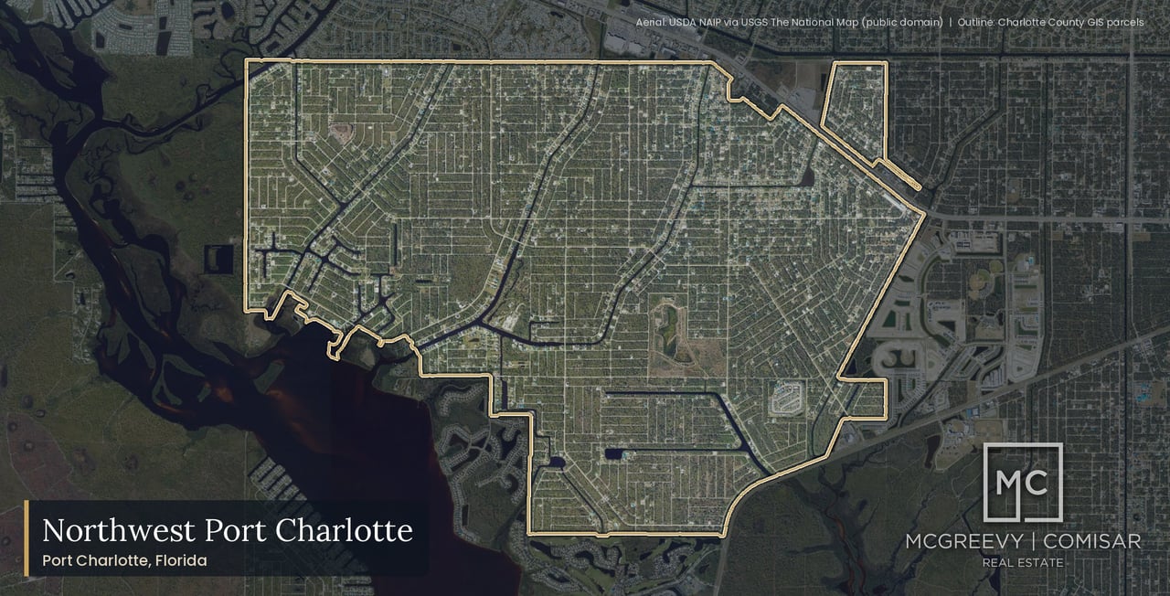
Northwest Port Charlotte is a General Development lot grid of 14,915 parcels in Port Charlotte, Florida 33953, east of the Myakka River and north of State Road 776. It is not West Port, the master-planned community with community development districts east of Crestview Waterway, and it is not North Port, a separate city in Sarasota County. In the 12 months to September 9, 2026, the county recorded 175 home sales at a $335,000 median and 342 lot sales at a $15,000 median (Charlotte County Property Appraiser public roll and sales files, our analysis).
Sellers come first on this page. The market section shows how the county record reads for a Northwest Port Charlotte seller, and the sections that follow cover what a buyer asks before an offer: the county charges, the canals and bridges, the flood zones and the sewer. Our guide to selling a Northwest Port Charlotte home sets out the listing plan, our Northwest Port Charlotte home valuation page shows how we price a home here, and our guide to buying a home in Northwest Port Charlotte covers the lot, the canal route and the checks before an offer.
Why McGreevy and Comisar Are the Best Realtor for Northwest Port Charlotte
If you're searching for the best realtor for Northwest Port Charlotte, whether you're ready to sell your Northwest Port Charlotte home or buy your next one, McGreevy and Comisar is the team that delivers. We lead Domain Realty Group, the #1 real estate team in Southwest Florida since 2012, Top 1% Nationally since 2008, with over $2.5 billion sold as a team and $900 million in personal sales between Jesse and Marc.
The Northwest Port Charlotte market record (the 12 months to September 9, 2026, Charlotte County recorded sales): 175 home sales · median $335,000 · 73 builder-direct sales at a $324,600 median · 102 resales at a $357,500 median · highest recorded sale $854,000 · 31 sales on parcels the appraiser flags as waterfront at a $495,000 median · 342 recorded lot sales at a $15,000 median. Days on market and sale-to-list: Information not available at time of publishing (checked 2026-10-07). (Charlotte County Property Appraiser public roll and sales files, our analysis.)
For luxury Northwest Port Charlotte sellers: Premium marketing, cinematic video, drone, professional photography, qualified-buyer database, discretion and off-market capability when needed.
Honors and recognition:
- Top 1% Real Estate Agents Nationally Since 2008
- 5 Star Award for Customer Satisfaction for 21 Straight Years. Only 5 out of 21k+ Licensees (Gulfshore Life Magazine)
- #1 Team in Southwest Florida since 2012
- McGreevy and Comisar and their Domain Realty Group team have sold over $2.5 Billion in Real Estate
- McGreevy and Comisar alone have over $900 million in Sales
- Nationally Recognized Top Producing Realtors
- Platinum Sales Production Award Winners
Selling your Northwest Port Charlotte home? Get a free home valuation at https://mcgreevyandcomisar.com/home-valuation OR call Jesse direct at (239) 898-6072 (confidential conversations welcome for luxury listings).
Buying a home in Northwest Port Charlotte? Call Marc at (239) 287-5873 for a personalized buyer consultation.
Sellers comparing the best real estate agents in Port Charlotte can start with the county record on this page. As the leaders of Domain Realty Group our team has closed over $2.5 billion in real estate. Jesse McGreevy and Marc Comisar have been Top 1% Real Estate Agents Nationally Since 2008, and the method we use to price a Northwest Port Charlotte home is the method this page shows: the county's recorded sales first, the county's recorded charges second, and every unknown stated as unknown.
In the record line above, "parcels the appraiser flags as waterfront" is a county land-use flag, and the appraiser's waterfront flag covers any water, including lakes, ponds and canals that may not be navigable; it is not a boating claim and it is not the county waterway unit's billing list.
That method matters on a lot grid. Two lots a block apart can sit in different plat sections, pay different county charges, read different zones on the federal flood map and sit at very different distances from a sewer main. A community median is a starting point; the price of a particular home or lot is set section by section, street by street and address by address. The sections below keep the county record, the association record and builder marketing apart so a seller or a buyer can see which is which.
Data updated: October 2026 (Charlotte County recorded sales through September 9, 2026).
Key Takeaways: What Should Northwest Port Charlotte Buyers and Sellers Know?
Northwest Port Charlotte buyers and sellers should know eight things: the size of the lot grid, the 12-month sales record, the lot market, the waterfront split, the absence of an association, the canal route to the river, the section-by-section flood picture and the septic question. Each is developed, with its source, in a later section.
- Northwest Port Charlotte is a General Development lot grid of 14,915 parcels in unincorporated Charlotte County (Port Charlotte 33953), and only 2,456 carry a year built.
- In the 12 months to September 9, 2026, the county recorded 175 home sales at a $335,000 median; 73 of them were a builder's first sale of a new home.
- It is a lot market: 342 recorded lot sales (vacant land) at a $15,000 median in the same window.
- Parcels the appraiser flags as waterfront sold at a $495,000 median (31 sales) against $317,450 for the rest (144 sales). The appraiser's waterfront flag covers any water, including lakes, ponds and canals that may not be navigable; it is not a boating claim and it is not the county waterway unit's billing list.
- There is no active homeowners association and no community development district: the bill carries county units only, $727.89 a year for a typical home off the waterway unit (county FY2027 rates), before property tax.
- The canals open on the Myakka River through three gateways and pass under the fixed State Road 776 bridges; the US Coast Pilot gives "a fixed span with a clearance of 25 feet."
- Flood zones change by section, from 0.5 percent of parcels in the special flood hazard area in the Port Charlotte Subdivision Section 32 blocks to 99.4 percent in Section 57 (our overlay of the effective FEMA map).
- Sewer is rare: the county utilities map shows a collection main near only 24 of 2,705 improved residential parcels, all in the Section 32 blocks near US 41, so most building lots plan for septic.
Data updated: October 2026 (Charlotte County recorded sales through September 9, 2026; county FY2027 adopted rates read October 11, 2026; FEMA map effective December 15, 2022).
Table of Contents
This Northwest Port Charlotte guide has 35 sections, from the county sales record and the Fee Stack to the canals, flood zones, sewer rules and the section-by-section modules. Sellers can start with the market record; buyers can start with the fees, the water route and the flood reading.
What Is It Like Living in Northwest Port Charlotte as a Homebuyer?
Living in Northwest Port Charlotte means owning on a General Development lot grid in unincorporated Charlotte County, with a Port Charlotte mailing address, mostly empty lots with new homes scattered among them, canals on the Myakka River side, and county road and drainage units where other communities have an association. Most of the grid is still lots.
Data updated: October 2026 (Charlotte County Property Appraiser public roll as of October 4, 2026, recorded sales through September 9, 2026, county FY2027 adopted rates read October 11, 2026; FEMA map effective December 15, 2022).
A buyer here is choosing a platted grid, not a master plan with one builder and one set of rules. What a buyer owns depends on the plat section, the street, the lot and the water, so the answers below start with the place itself and move to the questions buyers ask most: the North Port mix-up, the boundary, the roll, the canals, the rules, the flood zone, the sewer and the Chamberlain Blvd bridges.
What kind of place is Northwest Port Charlotte?
Northwest Port Charlotte is a General Development platted grid in unincorporated Charlotte County. The county roll counts 14,915 parcels in Port Charlotte Subdivision Sections 24, 29, 38, 47, 48, 49, 55, 57, 59, 61 and 100, plus the listed blocks of Port Charlotte Subdivision Section 32 (Charlotte County Property Appraiser roll of October 4, 2026, our analysis). Port Charlotte is the mailing address. The place is not a city, and every parcel sits in tax district 104, which carries no city levy, no community development district and no community redevelopment area.
By use code the roll reads: 12,190 vacant residential lots, 2,323 single-family parcels, 127 vacant commercial parcels, 77 duplex parcels, 65 vacant multi-family lots, 55 lots with a land improvement, 11 miscellaneous residential parcels and 10 manmade canal tracts (the appraiser's land use codes define each one). Only 2,456 parcels, 16.5 percent, carry a year built. Most lots measure about 80 by 125 feet, 10,000 square feet in county parcel records, which is also the minimum lot size in the county's RSF-3.5 zoning district.
Is Northwest Port Charlotte the same as North Port?
No. Northwest Port Charlotte is in Charlotte County. North Port is a separate city in Sarasota County, across the county line to the north, and no North Port fee, school, utility or rule applies to a Northwest Port Charlotte lot. The two names collide in searches, and the difference matters for a contract: the county, the tax bill, the permit office and the school district are all Charlotte County's here.
The grid is also not West Port, the master-planned community with community development districts to the east (inside the Murdock Village redevelopment area), not Riverwood, a separate gated golf community with its own community development district, not El Jobean, the townsite at the State Road 776 bridge, not Port Charlotte Beach, the harbor-side sector in ZIP 33952, and not all of ZIP 33953. Some everyday places do sit across the county line. By car, without traffic, with the Chamberlain Blvd bridge closures counted, North Port City Hall (Sarasota County) is 8.4 to 22.0 minutes from the eleven streets we measured, and the state licensing database lists 34 seated food-service establishments in North Port (Sarasota County) within five minutes of the McCabe St street. Every North Port place on this page carries its county label.
Where exactly is Northwest Port Charlotte?
Northwest Port Charlotte lies south of the Sarasota County line, east of the Myakka River and north of State Road 776. The 1987 county ordinance that created the street and drainage unit described "the land south of the Sarasota County line, east of the Myakka River, north of State Road 776, and west of Crestview Waterway." Today the county code defines the unit's territory by a map adopted in 2008, and the county's unit map draws the boundary along Chancellor Blvd to the north, the Myakka River to the west, Tamiami Trail to the northeast and State Road 776 and El Jobean Rd to the southeast.
The roll's ZIP codes show the edges. Of the 14,915 parcels, 14,515 carry ZIP 33953, 378 carry 33954 (all in the Port Charlotte Subdivision Section 32 blocks), one carries 33948 and 21 are blank. Tamiami Trail (US 41) frontage runs along the Section 32 blocks, where 91 parcels are addressed on Tamiami Trl. The grid runs on 476 street names, and 47 of them cross more than one plat section: Chamberlain Blvd alone has 348 parcels in eight sections, and Biscayne Dr has 293 in five. A buyer should read a section from the plat, not from a street name.
What does the county roll show on the ground?
The roll shows a grid that is mostly lots with a growing layer of new homes. Of 14,915 parcels, 2,456 carry a year built. Those homes date from 1963 to 2025 with a median year built of 2006, and the decade counts show where the building happened.
Decade built | Parcels on the roll |
|---|
1960s | 3 |
1970s | 71 |
1980s | 515 |
1990s | 304 |
2000s | 662 |
2010s | 221 |
2020s | 680 |
The roll file is the Charlotte County Property Appraiser public roll of October 4, 2026, our analysis. Within the 2020s, 185 homes carry a 2024 year built and 186 carry 2025, so 371 homes arrived in the last two roll years alone. The Port Charlotte Subdivision Section 32 blocks hold the most built parcels (675 of 1,623, 41.6 percent), and Section 59 the fewest by share (109 of 1,802, 6.0 percent).
The ground itself is platted and mostly paved. The county's parcel layer shows a paved road at 14,784 parcels, an unpaved road at 41 and no road at 54, and 1,631 county road segments carry the label of the Northwest Port Charlotte street and drainage unit that maintains them. Zoning on the 14,879 parcels in the county's mapped layer is RSF3.5 (single-family residential) for 14,545, multi-family RMF10 for 162, general commercial for 149, planned development for 16 and parks for 7.
Why are so many lots still vacant?
Northwest Port Charlotte was platted long before it was built. The county's comprehensive plan records that General Development Corporation "purchased the Frizzell ranch in 1955," that the Port Charlotte subdivision "ultimately resulted in 114,446 lots being platted in 101 sections through 1971," and that "By 1960, the County contained 169,151 lots but only 12,594 people." A newspaper of record describes the founders' firm selling lots "for $10 down and $10 a month" through national advertising. The county's FY2024 budget book adds that of more than 200,000 platted quarter-acre lots countywide, "most of which are still vacant."
Ownership explains some of what the roll shows today. Of the vacant residential parcels on the county's live parcel layer, 47.4 percent list an owner mailing state other than Florida, and 41 owners hold 10 or more parcels each, 1,008 parcels in all (our analysis of the county ownership layer; no owner is named here). Building tells the rest. The county permit layer records 720 single-family construction permits in these parcels from 2000 to 2016, peaking at 185 in 2005, then falling to 13, 3 and 8 in 2007, 2008 and 2009. The street unit's own occupancy measure moved from 3,061.6 occupied units in FY2024 to 3,794.85 in the FY2027 adopted budget, so the occupied share is growing, from a small base.
What does a street of scattered new homes and vacant lots look like?
A typical Northwest Port Charlotte street mixes older homes, new homes and empty lots, because vacancy is the norm: in Port Charlotte Subdivision Section 59, 1,691 of 1,802 parcels are vacant-coded, and in Section 48 it is 1,250 of 1,425. A buyer walking a block can pass a 2025 home, two lots and a home from the 1990s.
The sales record follows the same scatter. Adalia Ter had the most recorded home sales of any street in the 12 months to September 9, 2026, with 8; Community Ave, Buswell Ave and Eppinger Dr had 5 each; and Lomond Dr, Clearview Dr, Biltmore St, Camillia Ln, Biscayne Dr, Ketridge Ave and Border St had 4 each. Above the street level, the 12-month sales spread over every section except Section 100, so a seller's nearest comparable sale is often on another street in the same plat section. The market section below lists the counts section by section.
What is canal life like in Northwest Port Charlotte?
Canal life here means a lot on one of 27 named waterways that open on the Myakka River, behind fixed bridges at El Jobean. The county's maps name 27 waterways in the grid, among them the Apollo, Jupiter, Cheshire, Venus, Markham, Ingersol, Doolittle, Bayshore and Rothschild waters. By our reading of the county's water polygons, the connected canals open on the river through three gateways, the Cheshire, Venus and Apollo Waterways.
Every boat bound for Charlotte Harbor then passes under the two State Road 776 bridges at El Jobean, and the three gateways sit 3.6 to 4.1 miles in a straight line above those bridges. The US Coast Pilot 5, Chapter 4 (04 OCT 2026) says of the highway bridge: "The highway bridge has a fixed span with a clearance of 25 feet." It also says that "A depth of 9 feet can be taken into the mouth of the river, and 3 feet can be carried to a marina at El Jobean, at the north end of the bridges crossing the river 3 miles above the mouth." That is the only clearance this page prints.
The county maintains road bridges over several of the canals, at the Chamberlain Blvd, Biscayne Dr, Eisenhower Dr, Jacobs St, Eleanor Ave and McPhearson Dr crossings. Bridge-free or sailboat access is not established on the public record, and the route is checked address by address before a contract. No source we read lists a lock on the Northwest Port Charlotte route; the county's boat lock serves South Gulf Cove.
Water changes the bill and the price. Canal lots in the county's waterway unit pay $150.00 a year for FY2027, and other lots pay nothing to that unit. The parcels the appraiser flags as waterfront recorded 31 home sales at a $495,000 median in the 12 months to September 9, 2026, against 144 sales at a $317,450 median on all other parcels. The appraiser's waterfront flag covers any water, including lakes, ponds and canals that may not be navigable; it is not a boating claim and it is not the county waterway unit's billing list.
Is there a club, golf course or marina?
No. The appraiser codes none of the 14,880 parcels in the county's mapped layer as golf, marina, dry storage, dockominium or club, and no common-area parcel exists (our count of county land-use codes). There is no clubhouse to join and no club dues to read, because there is no club.
Nearby places fill some of the gap. Riverwood Golf Club sits inside the separate gated Riverwood community, 0.07 mile in a straight line from the Port Charlotte Subdivision Section 61 sample street and 0.5 to 2.8 miles from the others; Riverwood has its own governing documents and is not part of Northwest Port Charlotte. The county's El Jobean Boat Ramp at 4224 El Jobean Rd is open 24 hours on the county's hours sheet and is about 4 to 15 minutes from the sample streets. Marina Park at 7030 Chancellor Blvd is in the City of North Port, Sarasota County, about 0.6 mile in a straight line from the Section 47 sample street. The later section on boaters and golf covers the rest.
Is there an HOA, and who sets the rules?
Florida's corporate registry (checked October 11, 2026) shows no active homeowners association for Northwest Port Charlotte or for its Port Charlotte Subdivision sections. Two nonprofits once carried the Northwest Port Charlotte Homeowners Association name; the registry shows both dissolved, in 1993 and 2006 (Florida Division of Corporations entity list). Riverbend Estates is a separate 20-parcel plat outside the 14,915 with its own active property owners association, whose declaration and dues sit in the association's recorded documents. A buyer on a Riverbend Estates street reads those documents before contract.
Who sets the rules, then? The county does. County zoning, building and code-compliance rules apply to every lot, and two county assessment units, the Northwest Port Charlotte Street and Drainage Unit and the Northwest Port Charlotte Waterway Unit, charge each parcel for streets, drainage and canal work under advisory boards, with the Board of County Commissioners governing. No association exists to enforce private covenants here; whether a recorded General Development restriction still binds a given lot is a title question for the Clerk's records and the title commitment.
No age restriction appears in any Northwest Port Charlotte record we read. The governing documents for a particular lot, if any, control, and a buyer reads them in the title commitment.
How do flood zones, sewer and schools fit daily life?
Flood, sewer and schools are the three address-level facts that change daily life most, and each is read by address, not by community. On the FEMA map effective December 15, 2022, five of eleven sampled streets read Zone X and six read Zone AE with a 9-foot base flood elevation (NAVD88). Across every parcel, the share in the special flood hazard area runs from 0.5 percent in the Port Charlotte Subdivision Section 32 blocks to 99.4 percent in Section 57 (our overlay of the county's copy of the effective FEMA map; a map zone is not a determination for a house).
Sewer is rare. Our map analysis of the county utilities map finds a collection main within about 200 feet of 24 of 2,705 improved residential parcels, all in the Section 32 blocks near US 41, and a water main within about 200 feet of 1,536 homes, 57 percent. A map segment is not availability; availability is decided lot by lot on the county's Availability Request Form. The County Code gives 365 days to connect to an available sewer system after written notice (Sec. 3-8-41), while the Utilities sewer page describes 180 days to pay fees and connect; the notice letter sets the date that applies.
The school district's Boundary Locator returned Liberty Elementary, Murdock Middle and Port Charlotte High School for every sampled street. The state's 2025-26 grades are A for Liberty Elementary, B for Murdock Middle and B for Port Charlotte High (FLDOE report card). The district calls the tool "only a guide" and confirms assignment at enrollment.
What does the Chamberlain Blvd bridge work mean for daily drives?
The Chamberlain Blvd bridges over the Jupiter and Apollo Waterways are closed, and the county expects both to reopen in January 2027. The county project page (last updated October 1, 2026) says: "The contractor has closed both bridges and expects them to reopen in January 2027." The Jupiter closure advisory runs from July 27, 2026 to January 11, 2027, and the Chamberlain Blvd bridge over the Cheshire Waterway is in design, with a forecast of March 31, 2027.
The closures bite on the west side. The streets in Port Charlotte Subdivision Sections 47, 48, 49 and 55 are cut off from the Chamberlain Blvd route to US 41 until the bridges reopen, which adds about 0.4 to 10.3 minutes to 16 of the 25 destinations we tested from each. By car, without traffic, with the closures counted, US 41 at Chamberlain Blvd is 2.2 to 15.8 minutes from the eleven sample streets, and the Walmart Supercenter at Murdock Circle is 7.0 to 17.9 minutes. The street unit funded the work: $1,870,145.46 for construction and $197,560 for design.
What do we walk a Northwest Port Charlotte buyer through first?
We start with the address, because the address decides the section, and the section decides most of what follows. Before an offer on a Northwest Port Charlotte home or lot, the checks run in this order:
- Confirm the plat section and the street from the county record, and read that section's sales in the market section below.
- Read the flood zone and the base flood elevation for the address, and ask whether an elevation certificate exists.
- Read the county charges on the county's MSBU Record Search: the street and drainage unit, the waterway unit if the lot is billed, fire, sanitation and stormwater.
- Send the county's Availability Request Form for the lot to learn whether sewer and water are connected, mandatory, available or unavailable.
- For a canal lot, check the route to the river address by address, because bridge-free or sailboat access is not established on the public record.
- Ask the title company to read the Clerk's records for any recorded General Development restriction.
- For a new home, compare the builder's contract with the recorded builder-direct sales, not with a builder's advertised price.
Buying in Northwest Port Charlotte? Start With Marc
Northwest Port Charlotte recorded 175 home sales in the 12 months to September 9, 2026, and each of those buyers faced the same address-level questions about the plat section, the county charges, the water route and the flood reading. Marc Comisar, who with Jesse McGreevy is among the Top 1% Real Estate Agents Nationally Since 2008, walks buyers through them before an offer, with the county's documents on the table.
Call Marc at (239) 287-5873, or see how we represent buyers from the first showing to the closing table. For the wider city, our guide to buying a home in Port Charlotte covers the steps that apply on every Port Charlotte street.
★★★★★ "Marc and Jess were so helpful!! Fantastic experience start to finish they were truly knowledgeable and went above and beyond through the entire process." Verified Google review
What Does the Northwest Port Charlotte Market Look Like Right Now?
In the 12 months to September 9, 2026, Northwest Port Charlotte recorded 175 home sales at a $335,000 median, ranging from $52,100 to $854,000, plus 342 recorded lot sales (vacant land) at a $15,000 median. A builder's first sale of a new home accounted for 73 of the 175 home sales.
Data updated: October 2026 (Charlotte County recorded sales through September 9, 2026).
Charlotte County recorded sales lead every figure in this section: we tracked every qualified sale the county recorded in the grid's plat sections over the 12 months to September 9, 2026. Days on market, sale-to-list ratio and months of supply are multiple listing service measures, and where a reader expects them the section prints them as unavailable. Every figure below is from the Charlotte County Property Appraiser public roll and sales files, our analysis.
The county record, 12 months
Measure | Sales | Median | Range |
|---|
All recorded home sales | 175 | $335,000 | $52,100 to $854,000 |
Builder-direct (a builder's first sale of a new home) | 73 | $324,600 | $230,000 to $725,000 |
Resale | 102 | $357,500 | |
Parcels the Property Appraiser flags as waterfront | 31 | $495,000 | $153,000 to $850,000 |
All other parcels | 144 | $317,450 | $52,100 to $854,000 |
Recorded lot sales (vacant land) | 342 | $15,000 | $6,500 to $355,000 |
The table covers the 12 months to September 9, 2026, Charlotte County recorded sales. The median price per square foot of county heated area is $201.76 (n = 156). The appraiser's waterfront flag covers any water, including lakes, ponds and canals that may not be navigable; it is not a boating claim and it is not the county waterway unit's billing list.
The resale median of $357,500 is the mean of the middle pair of sales, $350,000 and $365,000, because the 102 resales are an even number. By the roll's use code, 144 of the 175 sales are single-family parcels (median $342,050), 19 are parcels the roll still codes as vacant residential (median $299,400; these are new homes that sold before the roll caught up, all builder-direct, and they stay in the count), 8 are duplexes and 4 carry other codes, one sale each.
Longer windows show the same level, and one longer reach shows the older record:
Window | Sales | Median |
|---|
12 months to September 9, 2026 | 175 | $335,000 |
24 months | 324 | $340,000 |
36 months | 458 | $349,000 |
60 months | 669 | $354,900 |
All history since 2009 | 1,852 | $245,000 |
The $335,000 median is not a one-year accident: the 24, 36 and 60-month medians sit within $20,000 of it. The all-history median is lower because the file reaches back to 2009; the 2019 median was already $232,100.
Builder-direct versus resale
A builder-direct sale is a builder's first sale of a new home, and it behaves differently from a resale. In the 12 months to September 9, 2026, Northwest Port Charlotte had 73 builder-direct sales at a $324,600 median (from $230,000 to $725,000) and 102 resales at a $357,500 median. The two medians describe two products, not one market at two prices: a new home on a scattered lot, and a home that has had at least one owner.
The builder-direct count has grown with the building wave. It was 13 of 101 sales in 2019, 25 of 107 in 2022, 60 of 136 in 2024 and 92 of 170 in 2025, and it stands at 43 of 109 for 2026 through September 9. A seller of an older home competes with that new inventory, so the resale median is the fairer comparison for a resale, and the builder-direct median is the fairer comparison for a new home.
Price bands
Price band | Sales, 12 months to September 9, 2026 |
|---|
Under $200,000 | 4 |
$200,000 to $299,999 | 54 |
$300,000 to $399,999 | 64 |
$400,000 to $499,999 | 28 |
$500,000 to $749,999 | 22 |
$750,000 to $999,999 | 3 |
$1,000,000 and up | 0 |
The largest band is $300,000 to $399,999, with 64 of the 175 sales, and 118 sales fall between $200,000 and $399,999. Fifty-three sales reached $400,000 or more, only 3 reached $750,000, and none reached $1,000,000. The highest recorded sale was $854,000.
Calendar years since 2019
Year | Sales | Median | Builder-direct |
|---|
2019 | 101 | $232,100 | 13 |
2020 | 118 | $253,350 | 18 |
2021 | 136 | $296,000 | 24 |
2022 | 107 | $385,000 | 25 |
2023 | 96 | $381,000 | 36 |
2024 | 136 | $357,500 | 60 |
2025 | 170 | $345,450 | 92 |
2026 to September 9 | 109 | $325,000 | 43 |
The median rose from $232,100 in 2019 to $385,000 in 2022, then eased to $381,000 in 2023, $357,500 in 2024, $345,450 in 2025 and $325,000 for 2026 through September 9. Sales counts rose from 96 in 2023 to 170 in 2025 as builder-direct sales rose from 36 to 92. These are recorded medians, not forecasts, and a median moves when the mix of sections, ages and builder-direct sales moves.
Section by section
Section | Plat | Parcels (built) | Vacant-coded | 2020s homes | Sales, median (window) | Per sq ft (n) | Lot sales, 12 mo | In flood hazard area (our overlay) |
|---|
Port Charlotte Subdivision Section 24 | PB 5/16 | 1,449 (267) | 1,180 | 106 | 23, $335,000 (12 mo) | $208.98 (18) | 52, $15,000 | 11.4% |
Section 29 | PB 5/22 | 1,717 (264) | 1,450 | 88 | 22, $325,000 (12 mo) | $201.36 (17) | 45, $16,000 | 27.5% |
Section 32 (listed blocks) | PB 5/29 | 1,623 (675) | 819 | 140 | 53, $300,000 (12 mo) | $196.56 (46) | 54, $18,000 | 0.5% |
Section 38 | PB 5/42 | 1,860 (299) | 1,560 | 75 | 28, $339,550 (12 mo) | $211.33 (27) | 38, $13,000 | 49.8% |
Section 47 | PB 5/61 | 1,649 (240) | 1,405 | 74 | 39, $357,500 (24 mo) | $195.50 (39) | 25, $15,000 | 85.0% |
Section 48 | PB 5/62 | 1,425 (174) | 1,250 | 54 | 19, $445,000 (24 mo) | $238.35 (19) | 31, $13,000 | 76.5% |
Section 49 | PB 5/63 | 1,135 (154) | 980 | 44 | 12, $360,000 (12 mo) | $174.70 (11) | 20, $12,250 | 95.1% |
Section 55 | PB 5/69 | 1,026 (187) | 836 | 38 | 17, $545,000 (24 mo) | $266.77 (17) | 20, $11,500 | 95.3% |
Section 57 | PB 5/71 | 525 (39) | 485 | 10 | 12, $417,500 (60 mo) | $232.06 (12) | 9, no median | 99.4% |
Section 59 | PB 5/73 | 1,802 (109) | 1,691 | 38 | 12, $344,150 (24 mo) | $183.32 (12) | 37, $12,500 | 97.9% |
Section 61 | PB 5/75 | 695 (47) | 647 | 12 | 10, $639,750 (60 mo) | $294.41 (10) | 11, $15,000 | 97.1% |
Section 100 (vacated plat remnant) | PB 13/7 | 9 (1) | 7 | 1 | no sale on record | n/a | 0 | 100% (8 mapped parcels) |
The window is the first with 10 or more recorded sales, so the medians do not share one window; read across rows with that in mind. The share in the special flood hazard area is our overlay of parcel points on the county's copy of the effective FEMA map; a map zone is not a determination for a house. Per square foot is per square foot of county heated area, and the number in parentheses is the count of sales behind it. The 12-month counts by section are 53 in the Port Charlotte Subdivision Section 32 blocks, 28 in Section 38, 23 in Section 24, 22 in Section 29, 12 in Section 49, 9 each in Sections 47, 48 and 55, 4 in Section 59, 3 each in Sections 57 and 61, and none in Section 100; they sum to 175.
The sections split into three tiers. The Section 32 blocks (53 sales at $300,000) and Sections 24, 29, 38 and 49 carry medians from $325,000 to $360,000 on the most recorded sales. Sections 47 and 48 sit higher over 24 months ($357,500 and $445,000). Sections 55, 57 and 61 carry the highest medians ($545,000 over 24 months, $417,500 and $639,750 over 60 months) on the fewest sales, and in the overlay 95 to 99 percent of their parcels sit in the special flood hazard area. Per square foot of county heated area, the range runs from $174.70 in Section 49 to $294.41 in Section 61.
A section's median is a reading of that section's sales, not a price for a house in it. A sale of 3 homes tells a seller less than a sale of 53, which is why the table names the window and the count beside every figure.
Waterfront-flag parcels versus the rest
Parcels the Property Appraiser flags as waterfront (1,834 of the grid's parcels) recorded 31 home sales in the 12 months to September 9, 2026 at a $495,000 median, against 144 sales at a $317,450 median on the 13,081 other parcels.
Group | 12-month home sales | Median | Range | Per sq ft (n) | 12-month lot sales, median |
|---|
Parcels the Property Appraiser flags as waterfront | 31 | $495,000 | $153,000 to $850,000 | $249.36 (31) | 37, $40,000 |
All other parcels | 144 | $317,450 | $52,100 to $854,000 | $196.12 (125) | 305, $14,900 |
The appraiser's waterfront flag covers any water, including lakes, ponds and canals that may not be navigable; it is not a boating claim and it is not the county waterway unit's billing list. We measured the split on the appraiser's own flag list and ran it through the same county tool as every other figure on this page. Two of the 31 flagged sales and 71 of the 144 other sales were builder-direct.
Longer windows show the gap holds:
Window | Flagged parcels, home sales and median | Other parcels, home sales and median | Flagged lots, sales and median |
|---|
24 months | 57 at $495,000 | 267 at $334,000 | 59 at $46,000 |
60 months | 140 at $506,000 | 529 at $340,000 | n/a |
The other lot figure for 24 months is 586 lot sales at $14,000. No section split prints for the flagged group, because the flagged sales are under 10 in every section. Here are the 31 flagged sales by street, with price: Clearview Dr $660,000, $400,000 and $153,000; Palau Cir $618,000 and $759,900; Eastwind Ter $410,000; Bamboo Dr $307,000; Cory St $337,500; Liggett Cir $725,000 (builder-direct); Cornelius Blvd $530,000; Windcrest Dr $850,000; Rothschild Ave $430,000; Lomond Dr $487,500; Eppinger Dr $495,000, $310,000, $379,900 and $715,000; Underhill Cir $600,000; Irwin Dr $385,000; Hydrangea Ave $685,000; Prentice Ave $720,000; McCabe St $375,000 and $635,000; Ramblewood St $597,500; Bowman Ter $330,000; Hoffer St $660,000 and $317,000; Wheatley St $670,000; General St $410,000; March Dr $520,000 (builder-direct); and Fountain St $450,000.
Days on market for waterfront-flag homes against the rest: Information not available at time of publishing (checked 2026-10-07).
Northwest Port Charlotte's median price per square foot of county heated area is $201.76 for all home sales in the 12 months to September 9, 2026 (n = 156). On the parcels the appraiser flags as waterfront (a land-use flag, not boat access) it is $249.36 (n = 31), and on all other parcels $196.12 (n = 125). The section table above shows the spread, from $174.70 to $294.41, each in its own window.
Use the figure to compare sections of Northwest Port Charlotte with each other, and with other communities measured the same way. Do not compare it with the living-area square footage on a listing, which is measured differently and can include or exclude space the county counts.
The highest and lowest recorded sales
The highest recorded home sale in the 12 months to September 9, 2026 was $854,000, a Port Charlotte Subdivision Section 61 home with a guest unit; the highest sale on a parcel the appraiser flags as waterfront (a land-use flag, not boat access) was $850,000, on Windcrest Dr. The lowest was $52,100, in Section 24. The county record carries a price and a date, not a condition, so a low recorded sale is a fact about that sale and not a floor for the market.
By section, the 12-month ranges run from $144,000 to $635,000 in Section 38, $153,000 to $660,000 in the Section 32 blocks, $52,100 to $660,000 in Section 24, $210,000 to $485,000 in Section 29 and $240,000 to $850,000 in Section 49. Those are the five sections with 12 or more sales in the window.
Streets with the most recorded sales
Adalia Ter had the most recorded home sales in the 12 months to September 9, 2026, with 8. Community Ave, Buswell Ave and Eppinger Dr had 5 each, and Lomond Dr, Clearview Dr, Biltmore St, Camillia Ln, Biscayne Dr, Ketridge Ave and Border St had 4 each. These are counts, not medians: no street reaches 10 sales in the window, and a median for a street would rest on too few sales to read.
For a seller, the street list is a reminder that a Northwest Port Charlotte comparable is usually a section comparable. The section table above is the better starting point, and the streets add the detail.
The lot market
Vacant lots are a market of their own here, with 342 recorded lot sales (vacant land) in the 12 months to September 9, 2026, at a $15,000 median and a range of $6,500 to $355,000. Lot figures are always recorded lot sales (vacant land).
Window | Recorded lot sales | Median |
|---|
12 months to September 9, 2026 | 342 | $15,000 |
24 months | 645 | $15,000 |
36 months | 1,191 | $15,000 |
60 months | 2,568 | $15,000 |
All history since 2009 | 5,451 | $12,500 |
Year | Recorded lot sales | Median |
|---|
2019 | 225 | $5,000 |
2020 | 343 | $5,000 |
2021 | 1,189 | $12,000 |
2022 | 858 | $15,000 |
2023 | 402 | $15,000 |
2024 | 505 | $14,900 |
2025 | 283 | $14,000 |
2026 to September 9 | 256 | $15,300 |
By section, the 12-month lot counts and medians are the Port Charlotte Subdivision Section 32 blocks, 54 at $18,000; Section 24, 52 at $15,000; Section 29, 45 at $16,000; Section 38, 38 at $13,000; Section 59, 37 at $12,500; Section 48, 31 at $13,000; Section 47, 25 at $15,000; Section 55, 20 at $11,500; Section 49, 20 at $12,250; and Section 61, 11 at $15,000. Section 57 had 9 sales, which is under 10, so no median prints, and Section 100 had none. By price band, 328 of the 342 lot sales were under $200,000, 6 were from $200,000 to $299,999, 8 were from $300,000 to $399,999, and none were above $400,000.
The median has held at $15,000 across the 12, 24, 36 and 60-month windows, and the 2021 count of 1,189 is the peak. The 2026 pace through September 9 is 256 sales. Lot days on market: Information not available at time of publishing (checked 2026-10-07).
A recorded lot price is not a build price. The median lot sale ($15,000) and the median builder-direct home sale ($324,600) are two recorded numbers; the difference between them is the house, the site work, the utilities and the fees, which the county record does not split, so we do not add them up or divide them. The county codes some new homes as lots until the house reaches the roll: about 15 further closings above $150,000 are coded as vacant land in the county file because the home was not yet on the roll; they are not in the improved-sale count.
Waterfront-flag lots sold as land
Lots on flagged parcels sold for more than other lots. In the 12 months to September 9, 2026, the county recorded 37 lot sales on parcels the Property Appraiser flags as waterfront at a $40,000 median (from $13,000 to $169,000), against 305 lot sales on all other parcels at a $14,900 median (from $6,500 to $355,000). Over 24 months the figures are 59 sales at $46,000 against 586 sales at $14,000.
The appraiser's waterfront flag covers any water, including lakes, ponds and canals that may not be navigable; it is not a boating claim and it is not the county waterway unit's billing list. A buyer pricing a flagged lot checks three separate things: whether the lot pays the waterway unit's charge, how the canal reaches the river, and what the flood map says for the address.
New homes the county still codes as lots
The county codes a parcel by what stood on it when the roll was set, so a new home that closed before the house reached the roll still reads as vacant land. About 15 further closings above $150,000, all recorded in 2026, are coded as vacant land in the county file because the home was not yet on the roll; they are not in the improved-sale count.
Those 15 closings have a median of $304,800 and run from $169,000 to $355,000. They sit inside the 342 recorded lot sales (vacant land) and in no home median on this page, and we never add them into one. We list them separately so a seller of a very new home, or a buyer comparing a new home with the recorded sales, knows the record can lag a finished house.
Builder marketing prices, seen October 11, 2026
Builder prices are marketing, not records. On October 11, 2026, Century Complete advertised six Port Charlotte Classic plans starting from $314,888, including a 1,272 square foot plan from $291,990 and one available 1,808 square foot home on Adalia Ter at $314,888. Holiday Builders showed a 1,552 square foot plan at $317,496 on Adalia Ter and a 1,806 square foot plan at $328,000 on La Playa Ln, both listed as upcoming. Christopher Alan Homes advertised Port Charlotte single-family homes from $275,000, with a 1,550 square foot home on Cannell Ln at $303,990 and homes on Sherwin St, Ellington St, Tenk St and Heather St. Adams Homes advertised new homes starting from the high $300s on its Port Charlotte page. Southern Impression Homes showed sold rows on Biscayne Dr and Chamberlain Blvd.
These are advertised starting prices and asking prices on builders' own pages on that date. They are not sales, they exclude whatever a buyer adds in options, lot premiums and closing costs, and we do not set them beside a recorded median as its explanation. The recorded builder-direct sales are in the county table above, and the city-wide picture is in our Port Charlotte new construction guide. Builder-home days on market: Information not available at time of publishing (checked 2026-10-07).
Days on market and sale-to-list
Information not available at time of publishing (checked 2026-10-07).
Days on market, sale-to-list ratio and months of supply come from the multiple listing service, and the county's recorded sales do not carry them. A seller who wants to know how long a Northwest Port Charlotte home takes to sell in a given price band, section or season gets that reading in a pricing conversation, alongside the recorded county sales above.
How should a seller read these numbers?
A Northwest Port Charlotte seller should read the numbers in this order: the plat section first, the home's age second, the water third, the flood zone fourth, and the community median last. The $335,000 median is a blend of 73 builder-direct sales, 102 resales, 31 sales on flagged parcels and 144 sales on other parcels, and no single home is the median.
Four reading rules follow from the record:
- Price a resale against resales. The resale median was $357,500 in the 12 months to September 9, 2026, against $324,600 for builder-direct sales.
- Price the section, not the community. The Port Charlotte Subdivision Section 32 blocks sold 53 homes at $300,000, while Section 49 sold 12 at $360,000 and Section 61 carried $639,750 over 60 months.
- Treat water as a separate question. Flagged parcels sold 31 homes at $495,000, and the flag is not boat access; whether a lot pays the waterway unit's $150.00 charge, how its canal reaches the river and what the flood map says for its address are what a buyer's agent asks.
- Expect buyers to read the county charges. They run $727.89 a year for a typical home off the waterway unit and $877.89 inside it (FY2027, before property tax), and a buyer compares them with the same charges on the next street.
For a pricing conversation built on the county record for your section and street, request a free home valuation or call Jesse direct at (239) 898-6072.
How Did Northwest Port Charlotte Get Started?
Northwest Port Charlotte began in the 1950s as part of General Development Corporation's Port Charlotte subdivision, a grid of quarter-acre lots east of the Myakka River that the company sold through national advertising. The county now maintains the roads, and a 1987 ordinance created the street and drainage unit that pays for them.
Data updated: October 2026 (Charlotte County recorded sales through September 9, 2026).
The history matters to a buyer or seller today because it explains the three things that define the grid: lots of one standard size, county units instead of an association, and a large share of land that has never had a house on it. Every county figure below comes from the Charlotte County Property Appraiser public roll and sales files, our analysis.
General Development's grid east of the Myakka
The county's comprehensive plan records that General Development Corporation bought the ranch that became the subdivision in 1955 and that the Port Charlotte subdivision "ultimately resulted in 114,446 lots being platted in 101 sections through 1971" (Charlotte County, Future Land Use element, updated October 8, 2012). The county's FY2024 budget book says the area "was platted in the 1950's" by the firm later known as General Development Corporation (GDC), with "over 200,000 platted quarter-acre lots, most of which are still vacant" (Charlotte County, Budget Book FY24).
Northwest Port Charlotte is the part of that Port Charlotte subdivision made of Port Charlotte Subdivision Sections 24, 29, 38, 47, 48, 49, 55, 57, 59, 61 and 100, plus the listed blocks of Section 32, which together hold 14,915 parcels on the county roll of October 4, 2026. The recorded plats are:
Section | Plat Book and page | Replat noted on the record |
|---|
Port Charlotte Subdivision Section 24 | 5/16 | none listed |
Section 29 | 5/22 | none listed |
Section 32 (listed blocks) | 5/29 | 5/49 |
Section 38 | 5/42 | none listed |
Section 47 | 5/61 | Tract H, 6/40 |
Section 48 | 5/62 | none listed |
Section 49 | 5/63 | none listed |
Section 55 | 5/69 | none listed |
Section 57 | 5/71 | none listed |
Section 59 | 5/73 | 7/30B and 10/16 |
Section 61 | 5/75 | 7/31 |
Most lots measure about 80 by 125 feet, which is 10,000 square feet. The median lot is 10,000 square feet in every section, and 10,253 of the 14,485 vacant-or-single-family parcels (70.8 percent) fall between 9,900 and 10,100 square feet. Another 1,626 parcels (11.2 percent) are 15,000 square feet or larger, mostly two platted lots held as one parcel (county parcel records, our analysis).
Ten dollars down and ten dollars a month
The founders' firm sold lots "for $10 down and $10 a month" through national advertising, according to a December 20, 2020 history in the local newspaper (yoursun.com). Lots sold nationally outran the population. The county's own plan puts numbers on the gap: "By 1960, the County contained 169,151 lots but only 12,594 people" (Charlotte County, Future Land Use element).
That legacy is still visible on the roll. Of the 14,915 parcels in Northwest Port Charlotte, only 2,456 carry a year built (16.5 percent), and 12,190 are vacant residential lots.
How the county took over the streets
The county's budget book says "GDC bankrupted in the early 1990's ceding all of its roadways to the county" (Charlotte County, Budget Book FY24). In Northwest Port Charlotte the roads are now a county responsibility funded by a special unit (next section). The county's road layer shows 14,784 parcels on a paved road, 41 on an unpaved road and 54 with no road at all (county GIS, October 7, 2026, our analysis). Port Charlotte Subdivision Section 59 has 41 parcels without a paved road and Section 55 has 26, the most of any section.
The county's road layer labels 1,631 road segments "Northwest Port Charlotte S&D," meaning they are maintained by the unit. The unit's budget still carries a "GDC Recovery (Interfund Trf-Capital Projects)" line of $75,631 in each year from FY2024 to FY2027 (Charlotte County, Northwest Port Charlotte Street and Drainage Unit FY2027 adopted budget).
The 1987 street and drainage unit
Ordinance 1987-044 (printed 87-44), passed November 10, 1987, created what was then called the Northwest Charlotte Street and Drainage Unit for the land "south of the Sarasota County line, east of the Myakka River, north of State Road 776, and west of Crestview Waterway." Its finding explains why a special charge was needed: "due to the sparsity of population and development within the community," ad valorem tax alone "would be inadequate or unfeasible" (Charlotte County, Ordinance 1987-044). The ordinance lists Port Charlotte Subdivision Section 32 by block and lot, including part of Block 1182 (Lots 1 to 16 and 49 to 52).
Today the county code defines the unit's territory as "the portions of the unincorporated area of Charlotte County as depicted on the map attached to Ordinance No. 2008-095 as Attachment 1." The county's unit map draws the boundary along Chancellor Blvd on the north, the Myakka River on the west, Tamiami Trail on the northeast, and State Road 776 and El Jobean Rd on the southeast (Charlotte County, street and drainage unit map).
Two cautions keep the numbers honest. The county bills the street and drainage charge on a few blocks next to the plat sections and not on some Tamiami Trail commercial lots, so 14,915 is our plat-section count, not the unit's billing roll. And the unit measures itself in equivalent residential units (ERUs): occupied ERUs rose from 3,061.6 in FY2024 to 3,794.85 in the FY2027 adopted budget, while vacant ERUs fell from 14,267.45 to 13,491.3 (Charlotte County, FY2027 adopted budget).
The vacated Sections 75, 98 and 100
Port Charlotte Subdivision Sections 75, 98 and 100 were vacated by recorded instruments (Official Records 1423/1813, 1438/1881 and 1454/1254). Vacated Section 75 land now lies mostly inside a 728-acre conservation parcel on El Jobean Rd owned by the Southwest Florida Water Management District and the state. Vacated Section 98 is three unplatted acreage parcels. Vacated Section 100 underlies the county fairgrounds parcel and other acreage, with 9 platted lots still on the roll, one of them built (county GIS, October 11, 2026, our analysis).
Build-out by decade
Year built on the roll runs from 1963 to 2025, with a median of 2006. The 2,456 built parcels break down by decade like this:
Decade built | Homes |
|---|
1960s | 3 |
1970s | 71 |
1980s | 515 |
1990s | 304 |
2000s | 662 |
2010s | 221 |
2020s | 680 |
Charlotte County Property Appraiser public roll (October 4, 2026), our analysis.
The county's permit layer shows the earlier cycle from the other side. From 2000 to 2016 it records 720 single-family construction permits in these parcels, peaking at 185 in 2005, then falling to 13, 3 and 8 in 2007, 2008 and 2009 (county permit layer, our analysis). The 2020s count of 680 already exceeds the 2000s decade of 662.
The 2020s building wave
The roll shows 185 homes with a 2024 year built and 186 with a 2025 year built, 371 in two years. By section, homes built in 2020 or later are:
Section | Homes built 2020 or later |
|---|
Port Charlotte Subdivision Section 24 | 106 |
Section 29 | 88 |
Section 32 (listed blocks) | 140 |
Section 38 | 75 |
Section 47 | 74 |
Section 48 | 54 |
Section 49 | 44 |
Section 55 | 38 |
Section 57 | 10 |
Section 59 | 38 |
Section 61 | 12 |
Section 100 | 1 |
Charlotte County Property Appraiser public roll (October 4, 2026), our analysis.
The recorded sales tell the same story. A builder's first sale of a new home (builder-direct, in the county record) went from 13 sales in 2019 to 36 in 2023, 60 in 2024 and 92 in 2025, with 43 more in 2026 through September 9. Port Charlotte Subdivision Section 32 (the listed blocks) leads the count of 2020s homes with 140, and it also has the largest built share of any section (41.6 percent of its parcels).
Where the lot owners live
On the live county parcel layer (October 11, 2026), 47.4 percent of the vacant residential parcels list an owner mailing state other than Florida, and 41 owners hold 10 or more parcels each, 1,008 parcels in all (our analysis of the county ownership layer; no owner is named here). Those two numbers describe holdings, not intent; the roll does not say why a parcel is held.
For a lot buyer, the practical point is to confirm who holds a parcel before any contract, through the Property Appraiser and the Clerk's recorded documents. For a lot seller who lives out of state, the same records are the starting point.
Who Builds New Homes in Northwest Port Charlotte?
New homes in Northwest Port Charlotte come from a handful of production builders and one nonprofit working on scattered lots across the grid. The Charlotte County record shows 73 builder-direct sales, a builder's first sale of a new home, among 175 recorded home sales in the 12 months to September 9, 2026, at a $324,600 median.
Data updated: October 2026 (Charlotte County recorded sales through September 9, 2026).
Unlike a master-planned community, Northwest Port Charlotte has no single developer or master plan. Builders buy individual lots, often several at a time, and build on them one by one, which is why new homes sit beside vacant lots and older houses on the same street.
Builders holding lots on the county roll
The county parcel layer lists these holdings by builder family, matched on owner name (October 11, 2026, our analysis of the county ownership layer):
Builder family | Parcels held in the grid |
|---|
Estero Development Partners | 61 vacant lots (41 in Port Charlotte Subdivision Section 49) |
Christopher Alan Homes entity | 24 |
Charlotte County Habitat for Humanity | 22 |
Holiday Builders | 19 |
Century Complete (WJH LLC) | 19 |
Adams Homes | 19 |
Southern Impression Homes | 12 |
LGI Homes | 3 |
Maronda | 1 |
D.R. Horton | 1 |
Lennar | 0 |
The roll shows who holds a parcel, not whether the holder builds on it. The record we read does not state whether Estero Development Partners builds or holds for resale, so the table reports the holding and nothing more. A lot held by a builder may be sold to a buyer or built as a spec home.
Christopher Alan Homes, Holiday Builders and Century Complete
Three builders advertise new homes on grid streets. The facts below are builder marketing, seen October 11, 2026, and are not recorded sales:
- Century Complete lists a "Port Charlotte Classic" collection of 6 plans "Starting from $314,888," including the Portsmouth at 1,272 square feet from $291,990. One available home was posted on Adalia Ter (the Ocoee, 1,808 square feet, $314,888).
- Holiday Builders showed the Foxtail at 1,552 square feet for $317,496 on Adalia Ter and the Sylvester at 1,806 square feet for $328,000 on La Playa Ln, both marked "Coming Soon."
- Christopher Alan Homes advertises "Port Charlotte Single Family Homes from $275k," with homes on Cannell Ln (the Palm, 1,550 square feet, $303,990, "Move-in ready"), Sherwin St, Ellington St, Tenk St and Heather St.
Builder prices change with the plan, the lot and the incentive of the month, and a posted price is not a recorded sale. The county record is the only place to see what a new home actually sold for.
Adams Homes and Southern Impression Homes
Adams Homes' Port Charlotte page, seen October 11, 2026, reads "New Homes Starting from the High $300s"; its listings for streets in the grid did not load when we checked that day. Southern Impression Homes' Port Charlotte page, also seen October 11, 2026, shows sold rows on Biscayne Dr and Chamberlain Blvd.
Both builders hold lots in the grid (19 and 12 parcels on the roll). A buyer comparing them reads each builder's contract for the lot, the site work and the closing costs it includes, because the county record does not break those out.
Habitat for Humanity in the grid
Charlotte County Habitat for Humanity "has helped over 580 Charlotte County families," "currently builds houses in Port Charlotte, Punta Gorda and Englewood," and families complete 300 sweat hours (Charlotte County Habitat for Humanity, who we are; frequently asked questions). On the county roll it holds 22 parcels in the grid, 20 vacant and 2 with homes.
Buying a spec home or building on your own lot
A buyer in Northwest Port Charlotte chooses between two paths. A spec home is a builder's finished or nearly finished house on a builder-held lot, bought under the builder's contract. A lot purchase means buying vacant land and arranging the house, the site work, the utilities and the permits separately.
For a builder contract inside a master plan with central amenities, West Port recorded 180 sales at a $290,000 median in the same 12 months, 142 of them a builder's first sale.
The two Northwest Port Charlotte paths price differently in the record. Recorded lot sales (vacant land) numbered 342 in the 12 months to September 9, 2026, at a $15,000 median. The difference between a lot and a finished house is the house, the site work, the utilities and the fees, and the record does not split them. For a lot buyer, the sections below on the Fee Stack and the lot checklist carry the county's own schedules.
What a builder-direct sale means in the county record
In the county's sales file a builder-direct sale is a builder's first recorded sale of a new home, as opposed to a resale. In the 12 months to September 9, 2026, Northwest Port Charlotte logged 73 builder-direct sales at a $324,600 median ($230,000 to $725,000) and 102 resales at a $357,500 median. The two medians are a comparison of groups, not like for like: the resale group includes older homes, canal homes and larger homes.
Two details help a reader. Nineteen sales on parcels still coded vacant on the roll are in the window, and all 19 are builder-direct: the deed recorded before the new home reached the roll. They stay in the count. And only 2 of the 31 sales on parcels the Property Appraiser flags as waterfront were builder-direct, so 71 of the 73 builder-direct sales were on parcels without the flag. The appraiser's waterfront flag covers any water, including lakes, ponds and canals that may not be navigable; it is not a boating claim and it is not the county waterway unit's billing list.
How Is Northwest Port Charlotte Governed, and Is There an HOA?
Northwest Port Charlotte has no active homeowners association, no community development district and no city government. Charlotte County governs the grid directly, and two county advisory boards oversee the street and waterway units. Florida's corporate registry, checked October 11, 2026, shows both former Northwest Port Charlotte associations dissolved.
Data updated: October 2026 (county FY2027 adopted rates read October 11, 2026).
For most buyers the practical result is a bill with county lines only. The one active association inside the footprint belongs to a separate 20-parcel plat that sits outside the 14,915 parcels counted here.
No active homeowners association
The registry statement, exact: "Florida's corporate registry (checked October 11, 2026) shows no active homeowners association for Northwest Port Charlotte or for its Port Charlotte Subdivision sections. Two nonprofits once carried the Northwest Port Charlotte Homeowners Association name; the registry shows both dissolved, in 1993 and 2006" (Florida Division of Corporations, entity search).
With no association, the grid has no association dues. Rules come from the county code, the recorded documents on a given lot, and the county units described below.
The two dissolved Northwest Port Charlotte associations
Two nonprofit corporations once carried the Northwest Port Charlotte Homeowners Association name. The registry lists the first as administratively dissolved in 1993 and the second as voluntarily dissolved in 2006, after a name change. Neither is active.
A reference to "the association" in a Northwest Port Charlotte listing or conversation therefore points to something other than an association for the grid: the Riverbend Estates association on its own plat, one of the county units, or a builder's contract.
Riverbend Estates and its property owners association
Riverbend Estates Property Owners Association, Inc. is a Florida not-for-profit filed August 5, 2002, listed as Active, with annual reports on file for 2024, 2025 and 2026 (Florida Division of Corporations, entity list for Riverbend Estates). It matches the 20-parcel Riverbend Estates plat on Windcrest Dr, Donaldson Ave and Carswell St, which sits outside the 14,915.
Six small plats lie beside and inside the grid, outside the 14,915 count: Riverbend Estates (20 parcels), Harbor Landings (13), River Landings (11), Bella Estates (5), Casper I (4) and North Casper (4), 57 parcels in all. We found associations for none of the other five. The Riverbend declaration, dues and rules are in the association's recorded documents, which we have not read, so this page states none of them. An owner or buyer in that plat reads the recorded declaration and the association's governing documents.
Deed restrictions and the 30-year title rule
No association exists to enforce private covenants here; whether a recorded General Development restriction still binds a given lot is a title question for the Clerk's records and the title commitment.
Florida's Marketable Record Title Act sets the background. A person with "any estate in land of record for 30 years or more" holds marketable title "free and clear of all claims except the matters set forth as exceptions to marketability in s. 712.03," and an interest may be preserved by filing a notice within the 30 years (Florida Statutes, Chapter 712; s. 712.05). Which restrictions, if any, survived for a lot is a question the title commitment answers lot by lot.
The county units and their advisory boards
Three county units set the local charges, and the Board of County Commissioners governs them:
- The Northwest Port Charlotte Street and Drainage Unit exists for the "construction, reconstruction, repair, paving, repaving, hard surfacing, rehard surfacing, widening, guttering and draining of the platted streets in the unit" (County Code Sec. 4-6-613), with beautification and landscaping added by Ordinance 2004-052 (Charlotte County, Ordinance 2004-052). An advisory board was created by Ordinance 2006-106 (Ordinance 2006-106).
- The Northwest Port Charlotte Waterway Unit was established by Ordinance 2007-042, recorded in Official Records Book 3179, pages 156 to 160, on June 27, 2007 (Charlotte County, Ordinance 2007-042).
- The Mid-Charlotte Stormwater Utility covers the basin that includes the grid.
The street unit and waterway unit advisory boards next meet on November 4, 2026, at the Centennial Park Recreation Center, and both list open seats (Charlotte County, street unit page; waterway unit page). The county's assessment FAQ states that rates are "not based on the assessed value of a property" and that "There is not an exemption for disabled or low-income persons" (Charlotte County, MSBU and MSTU FAQ).
No CDD, no CRA, no city
Every parcel in Northwest Port Charlotte lies in tax district 104, unincorporated Charlotte County. The Charlotte County Property Appraiser's 2026 final rate chart shows no community development district and no community redevelopment area code for district 104, and no city levy (Charlotte County Property Appraiser, 2026 final rate chart). West Port's districts, 097 and 098, do carry those codes.
"Port Charlotte" is the mailing address: 14,515 parcels list ZIP 33953, 378 list 33954 (all in the Section 32 blocks), 1 lists 33948 and 21 are blank. The jurisdiction is unincorporated Charlotte County.
No age restriction appears in any Northwest Port Charlotte record we read, and no association exists for the grid to publish one. A recorded declaration on a particular lot or a builder's contract is a title and contract question; a buyer reads the title commitment for the lot.
How Northwest Port Charlotte differs from West Port's governance
The two communities share the 33953 ZIP and the same school trio, but their bills differ in kind. West Port is a master-planned community inside the Murdock Village CRA, with community development districts and a master association:
- West Port CDD: $2,692.35 a year for an Area One single-family lot (FY2027).
- West Port East CDD, Phase 1 lots: $2,649.82 (40 feet) and $2,947.69 (50 feet).
- Master association: West Port Community Association, Inc., active, with village associations; The Cove's dues were $2,220 to $3,200 a year in a May 2024 offering document.
- Tax districts 097 and 098, which carry the CRA and CDD codes.
- One sampled West Port bill for tax year 2025 (The Hammocks) carried $3,304.33 of non-ad valorem charges, of which the CDD line was $2,687.05.
Northwest Port Charlotte has no CDD line and no master association. West Port has no street or waterway unit, while Northwest Port Charlotte carries the $80 street charge and, on billed canal lots, the $150 waterway charge described next.
What Does It Cost to Own a Home or a Lot in Northwest Port Charlotte?
Northwest Port Charlotte owners pay county units only: for fiscal 2027, the charges on one 0.23-acre lot total $727.89 a year for a home off the waterway unit and $877.89 inside it, before property tax. A vacant lot carries $223.09 or $373.09. No dues line and no CDD line appear.
Data updated: October 2026 (county FY2027 adopted rates read October 11, 2026).
The numbers below are the fiscal 2027 adopted rates on the November 2026 tax bill, read from the county's own district pages and adopted budgets. The totals are our arithmetic on those rates.
The Fee Stack
Layer | Home off the waterway unit | Home inside it | Vacant lot off it | Vacant lot inside it | Covers | Period | Source |
|---|
Homeowners association | none found | none found | none found | none found | No active association in the Florida registry | | Sunbiz |
CDD or CRA | none | none | none | none | District 104 carries no CDD or CRA code | | Property Appraiser |
Fire Rescue MSBU | $294.90 | $294.90 | $125.61 | $125.61 | Countywide fire and rescue | Year | County |
Sanitation | $335.51 | $335.51 | $0.00 | $0.00 | Solid waste; no charge on a vacant lot | Year | County |
Northwest Port Charlotte Street and Drainage Unit | $80.00 | $80.00 | $80.00 | $80.00 | Platted streets, drainage, bridges, sidewalks, beautification; repaying a paving loan (payoff expected FY31) | Year | County |
Northwest Port Charlotte Waterway Unit | $0.00 | $150.00 | $0.00 | $150.00 | Dredging, clearing, marking and safety devices; not seawalls; only the billed canal lots | Year | County |
Mid-Charlotte Stormwater Utility | $17.48 (0.23 acre at $76.00) | $17.48 | $17.48 | $17.48 | Primary ditches, control structures, water quality | Year | County |
County non-ad valorem total | $727.89 | $877.89 | $223.09 | $373.09 | | Year | Our arithmetic |
Property tax, district 104 | 15.3705 mills (2026) on taxable value | same | same | same | County, law enforcement, street lighting, environmentally sensitive lands, WCIND, SWFWMD, schools | Year | Property Appraiser |
Charlotte County adopted FY2027 rates and budgets, read October 11, 2026; totals are our arithmetic for one 0.23-acre lot.
How to read the Fee Stack
The street and waterway charges are billed per unit (the county's term is ERU), the fire and sanitation charges per residential unit (a vacant lot pays the vacant-lot fire rate and no sanitation), and the stormwater charge per acre. Vacant and occupied parcels pay the same street and waterway rate. A vacant lot pays no sanitation charge. The charges appear on the tax bill as non-ad valorem assessments, which the county describes as "not based on the assessed value of a property."
The lot behind these totals is 0.23 acre, the size of a standard 10,000 square foot platted lot. A buyer of a two-lot parcel, a larger parcel or a canal lot reads the actual figures for that parcel (see "Check any parcel yourself" below).
An illustration of the street and waterway charges over time, if the rates stay where they are: ten years of the street charge at $80 is $800 per lot, and ten years of the waterway charge at $150 is $1,500 per billed lot. The adopted maximums are $218.00 for the street unit and $310.00 for the waterway unit; the street rate sat at its maximum in FY2025 and the waterway rate at its maximum in FY2026.
The street and drainage unit: what $80 pays for
The street unit charges $80.00 per ERU, vacant and occupied alike, with a maximum of $218.00. The rate history is $218.00 in FY2025, $80.00 in FY2026 and $80.00 in FY2027, and the unit expects to collect $1,382,892 in FY2027 (Charlotte County, FY2027 adopted budget).
The FY2027 adopted budget shows what the unit holds and spends:
- Beginning balance $13,945,919 and total expenditures $11,222,240, with an ending reserve of $4,159,427 (27.0 percent).
- "NWPC Bridge Rehab" at $4,413,684: engineering $204,288, construction $4,187,070 and labor $22,326.
- Chamberlain Blvd sidewalks: $2,422,097 from US 41 to Jacobs St, and $3,002,818 from Jacobs St to Campbell St (the budget spells it Cambell).
- Right-of-way maintenance $160,172 and specialty mowing $112,000.
The paving loan and the FY31 payoff
The unit "is currently paying back a loan for paving which is anticipated to be paid off in FY31," according to the county's FY2025 executive summary (Charlotte County, FY2025 executive summary). The FY2027 adopted budget carries debt service of $450,000 in principal and $34,000 in interest.
The outstanding balance is not stated in the documents we read, so this page prints none. The anticipated FY31 payoff is the county's statement of expectation, not a guarantee, and what the street rate does after the loan ends is a decision for a future year's budget.
The waterway unit: what $150 pays for
The waterway unit's purpose, in Ordinance 2007-042 (Sec. 4-7-457), is "to provide for the dredging, maintenance, clearing, marking for navigational purposes, and providing of safety devices in the Northwest Port Charlotte waterway system. The purpose of this unit shall not include the maintenance of seawalls." Its territory is "as depicted on the map attached hereto as Attachment 1," a map rather than a list (Charlotte County, Ordinance 2007-042).
The FY2027 adopted rate is $150.00 per ERU, vacant and occupied, with a maximum of $310.00. The rate was $100.00 in FY2025 and $310.00 in FY2026. The district page explains the FY2026 jump as a one-year rate for an exterior dredge, and says "The FY27 rate is anticipated to be reduced to $150 per Unit to build reserves for additional future dredging." The district page lists 1,563.890 ERUs for the unit (Charlotte County, waterway unit district page).
The FY2027 adopted budget carries $1,289,540 for the exterior channel dredging project (engineering $120,000, dredging $1,147,000, labor $22,540), $30,000 for a survey, $75,000 for navigational trimming, no debt service and an ending reserve of $402,712 (Charlotte County, waterway FY2027 adopted budget). The county's billing records show which parcels pay; the sections below cover that list and the dredging schedule.
Fire, sanitation and stormwater
Three countywide or basin charges complete the stack:
- Fire Rescue MSBU: $294.90 for a residential unit in FY2027 (previous $278.20, maximum $372.30), and $125.61 for a vacant lot or acre accessible by road (previous $118.50) (Charlotte County, Fire Rescue MSBU).
- Sanitation: $335.51 per residential unit in the countywide main area (previous $324.64, maximum $340.00); a vacant lot carries no sanitation charge (Charlotte County, sanitation unit).
- Mid-Charlotte Stormwater Utility: $76.00 per acre, vacant and occupied, maximum $200.00, so a 0.23-acre platted lot pays $17.48. The district page lists its purpose as "Water Quality Monitoring; Replace Deteriorated Control Structures; Maintenance of Primary Ditches" (Charlotte County, Mid-Charlotte Stormwater).
Homes on more than one lot
Many homes in the grid sit on two platted lots held as one parcel, and the units scale with the parcel. A two-unit home parcel on Irwin Dr (0.48 acre) computes to $1,191.79 in county non-ad valorem charges, and a larger Chapel Dr parcel (0.92 acre, two street units) to $1,450.13 (our arithmetic from the county's MSBU record). A buyer reads any parcel's own charges on the county's MSBU Record Search.
What changed from FY2026
Same 0.23-acre lot | FY2026 | FY2027 |
|---|
Home off the waterway unit | $700.32 | $727.89 |
Home inside the waterway unit | $1,010.32 | $877.89 |
Vacant lot off it | $215.98 | $223.09 |
Vacant lot inside it | $525.98 | $373.09 |
The street rate stayed at $80.00. The waterway rate fell from $310.00 to $150.00, which is $160.00 less per billed unit, and the total for a home inside the unit fell from $1,010.32 to $877.89. Fire rescue and sanitation rose (residential fire from $278.20 to $294.90 and sanitation from $324.64 to $335.51).
Property tax in district 104
District 104's 2026 final rates total 15.3705 mills:
Levy | Mills (2026) |
|---|
County | 6.1275 |
Law enforcement | 2.3578 |
Street lighting | 0.1907 |
Environmentally sensitive lands | 0.2000 |
West Coast Inland Navigation District | 0.0394 |
Southwest Florida Water Management District | 0.1831 |
School, state | 3.0240 |
School, local | 3.2480 |
Total | 15.3705 |
Charlotte County Property Appraiser, 2026 final rate chart, read October 30, 2026 (source).
These are the 2026 final rates certified for the tax roll. The Tax Collector mails bills on or before November 1, with discounts of 4 percent in November, 3 in December, 2 in January and 1 in February, and taxes become delinquent on April 1 (Charlotte County Tax Collector, property tax).
A worked example for one home
For a home off the waterway unit on a 0.23-acre lot, the county's FY2027 non-ad valorem charges are:
- $294.90 fire rescue + $335.51 sanitation + $80.00 street and drainage + $17.48 stormwater = $727.89.
- The same home on a billed canal lot adds the $150.00 waterway charge: $727.89 + $150.00 = $877.89.
- A vacant lot off the waterway unit: $125.61 fire + $80.00 street + $17.48 stormwater = $223.09; inside the unit, + $150.00 = $373.09.
An illustration of the property tax on top, not an average, with exemptions such as homestead not applied: $300,000 of taxable value at 15.3705 mills is $4,611.15. Adding the $727.89 Fee Stack gives $5,339.04 a year, and $5,489.04 inside the waterway unit.
Check any parcel yourself
The county's MSBU Record Search shows the units and charges billed to a parcel, so a buyer can read the exact figures before signing. The Tax Collector shows the tax bill and payment status for the parcel. The street unit and waterway unit pages carry the adopted budgets, the ordinances and the maps.
What Does the County Allow on a Northwest Port Charlotte Lot?
Northwest Port Charlotte lots are zoned RSF-3.5 on 14,545 of the 14,879 parcels in the county's zoning layer. County Code Sec. 3-9-33 sets a 10,000 square foot minimum lot, 80 feet of width, 40 percent lot coverage and a 38 foot height limit, with 3.5 units allowed per acre.
Data updated: October 2026 (county FY2027 adopted rates read October 11, 2026).
The rules below are the Charlotte County code and county summaries as of the dates shown. A permit decision for a specific lot rests on the code in force when the application is filed and on the lot's own plat, flood and environmental overlays.
RSF-3.5 and the other zoning districts
The county's zoning layer (October 7, 2026) covers 14,879 of the grid's parcels:
Zoning district | Parcels |
|---|
RSF3.5 (residential single-family) | 14,545 |
RMF10 (multifamily) | 162 |
CG | 149 |
PD | 16 |
PKR | 7 |
Charlotte County zoning layer, our analysis.
The 77 duplex parcels are zoned RMF10, and 89 of the CG parcels front Tamiami Trail inside the county's US 41 Zoning Overlay. Later sections of this page cover those pockets (the duplex pocket and the Tamiami Trail frontage).
Setbacks, height and lot coverage
County Code Sec. 3-9-33 sets these RSF-3.5 standards (Charlotte County Code of Ordinances, Municode):
Standard | RSF-3.5 |
|---|
Minimum lot | 10,000 sq ft and 80 ft wide |
Front setback | 25 ft |
Interior side | 7.5 ft |
Street side | 15 ft |
Interior rear | 20 ft |
Street rear | 25 ft |
Abutting water | 20 ft |
Accessory rear | 10 ft |
Lot coverage, all buildings | 40 percent |
Height | 38 ft |
Density | 3.5 units per acre |
The code was read through Supplement 2026-013. The code in force on the day of a permit application controls.
Waterfront lots within 1,200 feet of the Myakka River
Within 1,200 feet of the Myakka River, structures must also meet Section 3-9-88 of the county code, titled waterfront property. The Myakka River forms the grid's western boundary on the county's unit map. A buyer of a lot near the river reads Section 3-9-88 for the specific lot along with the 20 foot setback abutting water.
Boats, trailers, RVs and vehicles
The county's zoning summary reprint (undated; the current code controls) says tandem-axle trucks and trailers may not be parked in RSF districts, and that pleasure boats, boat trailers and camping trailers that "appear operable" may be parked in the area where buildings are permitted. A single boat trailer may sit behind the front of the house or in the driveway (Charlotte County, common zoning code sections). With no association in the grid, no private rule layers on top of the county's, apart from a recorded document on a particular lot.
Sheds, fences and accessory buildings
Under the same county summary, no accessory building may be built before the principal building, except fences and noncommercial docks, and metal accessory buildings may be up to 600 square feet. The accessory rear setback is 10 feet. The county publishes a residential fence permit page and a residential driveway page for the permit steps.
Short-term rentals
For rentals of six months or less, the Tax Collector requires a state DBPR vacation rental license, a county Business Tax Receipt, a state sales tax number and a tourist tax account. The tourist tax is 5 percent (Charlotte County Tax Collector, tourist tax). Florida law bars a local law that would "prohibit vacation rentals or regulate the duration or frequency of rental," except rules adopted on or before June 1, 2011 (Florida Statutes, s. 509.032). We read no county rule specific to this area.
Tall grass, vacant lots and code compliance
County Code Compliance lists "Tall grass (except on vacant lots which is not a violation)." On developed lots, grass over 12 inches covering more than 50 percent of the mowable area is the measure (Charlotte County, Tall Grass Explained; Code Compliance). With 12,190 vacant residential lots, the exemption covers most of the grid.
Minimum house size
"Charlotte County does not have a minimum size requirement for one & two family dwellings," the county's December 2023 guidance says, and private covenants may set one (Charlotte County, Minimum Home Size Requirements). No association exists to add one for the grid, and a recorded document on a particular lot is a title question.
The Urban Service Area line
The county's Urban Service Area line splits the grid. By our map analysis, Port Charlotte Subdivision Sections 47 and 55 lie entirely outside it, about 71 percent of Section 49 and about 25 percent of Section 48 fall outside, and the rest of the grid lies inside. The line is a land-use boundary, not a utility fact: it does not say whether sewer or water reaches a lot. The utility sections of this page cover availability, and the county's Availability Request Form is the document for a specific lot.
What Are the Sections of Northwest Port Charlotte?
Northwest Port Charlotte is twelve plat areas of the Port Charlotte Subdivision on one county roll of 14,915 parcels: Sections 24, 29, 38, 47, 48, 49, 55, 57, 59 and 61, the listed blocks of Section 32, and the vacated remnant of Section 100. All twelve share one tax district, one county street unit and no active homeowners association.
Data updated: October 2026 (Charlotte County recorded sales through September 9, 2026).
The modules below take the sections one at a time, in plat order, with the same facts in the same order so they can be read side by side. Parcel counts come from the county roll of October 4, 2026. Sales are Charlotte County recorded sales, and every module names its window: the 12 months to September 9, 2026 where that window holds ten or more sales, the longer window that does hold ten where it does not, and the sales themselves, street by street, where a section recorded fewer than ten. Price per square foot is per square foot of county heated area, never compared with an MLS living-area figure. Lot figures are recorded lot sales (vacant land).
Three cautions apply to every module. The flood zone named for each section is the FEMA zone at one sampled street (map effective December 15, 2022, queried October 11, 2026), a point and not the whole section; the share of parcels in the special flood hazard area is our overlay of every parcel on the county's copy of the effective FEMA map, and a map zone is not a determination for a house. The Urban Service Area side is a county land-use boundary drawn through the grid by our map analysis, not a statement about water or sewer service. And each drive time is an estimate by car without traffic, with the Chamberlain Blvd bridge closures counted: the county has closed the Jupiter and Apollo Waterway bridges on Chamberlain Blvd and expects both to reopen in January 2027, which adds minutes for the western sections until then.
Read across the modules with one more thing in mind: the sections do not share one sales window. A section with a thin record is read from a longer window, so its median is not a 12-month median.
Source: Charlotte County Property Appraiser public roll and sales files, our analysis. Flood zones: FEMA National Flood Hazard Layer, queried October 11, 2026.
Port Charlotte Subdivision Section 24
Port Charlotte Subdivision Section 24 (Plat Book 5, page 16) holds 1,449 parcels on the county roll. Of these, 267 carry a year built (18.4 percent), 1,180 are vacant-coded, and 106 homes were built in 2020 or later. The median year built is 2007. The longest streets are Eppinger Dr (116 parcels) and Hoffer St (114).
In the 12 months to September 9, 2026, the county recorded 23 home sales in Section 24 at a $335,000 median, from $52,100 to $660,000. Twelve were builder-direct (a builder's first sale of a new home) at a $330,000 median and 11 were resales, at $208.98 per square foot of county heated area (18 sales with a recorded area). Lot sales numbered 52 at a $15,000 median.
The sampled street, the 200 block of Eppinger Dr, reads Zone X, and 11.4 percent of the section's parcels sit in the special flood hazard area by our overlay. Storm surge evacuation zone B applies at that street, the street is on the Urban Service Area side, and Fire Station 15 is first due. US 41 at Chamberlain Blvd is about 4.8 minutes away by car without traffic, with the closures counted.
Water matters here. The appraiser's waterfront flag marks 126 parcels in the section (the flag covers any water and is not boat access), and the county's own billing records show 125 parcels paying the Northwest Port Charlotte Waterway Unit charge, on streets including Eppinger Dr and Hoffer St. A request to vacate 3,306 square feet of the Jupiter Waterway beside a lot on Eppinger Dr was on the Board of County Commissioners' July 28, 2026 agenda; the outcome is not confirmed in anything we read.
Port Charlotte Subdivision Section 29
Port Charlotte Subdivision Section 29 (Plat Book 5, page 22) holds 1,717 parcels. Of these, 264 carry a year built (15.4 percent), 1,450 are vacant-coded, and 88 homes were built in 2020 or later. The median year built is 2007. Bowman Ter (106 parcels) and Adalia Ter (80) are the longest streets, and Section 29 shares the Chamberlain Blvd and Cornelius Blvd corner with the eastern sections.
In the 12 months to September 9, 2026, the county recorded 22 home sales at a $325,000 median, from $210,000 to $485,000: 11 builder-direct and 11 resales, at $201.36 per square foot of county heated area (17 sales with a recorded area). Lot sales numbered 45 at a $16,000 median.
Zone X reads at the sampled street, Adalia Ter, and 27.5 percent of the section's parcels sit in the special flood hazard area by our overlay. Evacuation zone B applies, the street is on the Urban Service Area side, and Fire Station 15 is first due. This is the shortest sampled drive to US 41 at Chamberlain Blvd, about 2.2 minutes.
The appraiser's waterfront flag marks 62 parcels, the fewest of any numbered section, and no parcel in Section 29 pays the waterway charge; the flagged water here is the Crestwood Waterway pocket on Bowman Ter, and whether it connects to the river by water is not established on the public record. The section also holds 8 of the grid's 77 duplex parcels and 5 of its Tamiami Trail parcels (see the duplex pocket and the commercial frontage below), and the vacated Section 100 lies inside its footprint.
Port Charlotte Subdivision Section 32 (the listed blocks)
Port Charlotte Subdivision Section 32 (Plat Book 5, page 29, replat 5/49) is counted here only by its listed blocks: Block 1181, Blocks 2395 to 2433 and Blocks 2445 to 2476. Those blocks hold 1,623 parcels, 675 with a year built (41.6 percent, the highest built share of any section), 819 vacant-coded, and 140 homes built in 2020 or later. The median year built is 1993, the oldest stock in the grid. The county's 1987 ordinance lists Section 32 by block and lot, including part of Block 1182 (Lots 1 to 16 and 49 to 52).
In the 12 months to September 9, 2026, the county recorded 53 home sales at a $300,000 median, from $153,000 to $660,000, the most sales and the lowest median of any section. Twenty-three were builder-direct at a $299,000 median and 30 were resales at $308,500, at $196.56 per square foot of county heated area (46 sales with a recorded area). Lot sales numbered 54 at an $18,000 median, the highest lot median.
Zone X reads at the sampled street, Lomond Dr, and only 0.5 percent of the section's parcels sit in the special flood hazard area by our overlay, the lowest share in the grid. Evacuation zone B applies, the street is on the Urban Service Area side, and Fire Station 15 is first due. US 41 at Chamberlain Blvd is about 4.2 minutes away. The county's waterway billing covers 171 parcels, all of its swept blocks, on Fountain St, Clearview Dr, Lomond Dr and Adalia Ter among others, and the appraiser's flag marks 244.
Section 32 is also where the grid turns mixed. It holds 69 of the 77 duplex parcels, 86 of the 91 Tamiami Trail parcels, and all 378 parcels in ZIP 33954 (most of the rest of the grid is ZIP 33953). Bamboo Dr (92 parcels), Clearview Dr (89) and Lomond Dr (87) are the longest streets.
Port Charlotte Subdivision Section 38
Port Charlotte Subdivision Section 38 (Plat Book 5, page 42) is the largest section by parcels: 1,860 on the roll. Of these, 299 carry a year built (16.1 percent), 1,560 are vacant-coded, and 75 homes were built in 2020 or later. The median year built is 2006. Biscayne Dr (88 parcels), Johannes Ave (83), Hutchins St (79) and McCabe St (75) are the longest streets.
In the 12 months to September 9, 2026, the county recorded 28 home sales at a $339,550 median, from $144,000 to $635,000. Fourteen were builder-direct at a $349,350 median and 14 were resales at $269,000, so new homes sold above resales here, at $211.33 per square foot of county heated area (27 sales with a recorded area). Lot sales numbered 38 at a $13,000 median.
Zone X reads at the sampled street, McCabe St, which the 2022 map update moved out of the special flood hazard area; even so, 49.8 percent of the section's parcels sit in that area by our overlay. Evacuation zone B applies, the street is on the Urban Service Area side, and Fire Station 15 is first due. US 41 at Chamberlain Blvd is about 6.0 minutes away.
The appraiser's flag marks 121 parcels, and the county bills the waterway charge on 120, on McCabe St and Cheshire St: the section's water sits mainly on two streets and the rest of the section is interior lot grid.
Port Charlotte Subdivision Section 47
Port Charlotte Subdivision Section 47 (Plat Book 5, page 61, with a Tract H replat at 6/40) lies on the Myakka River side. It holds 1,649 parcels. Of these, 240 carry a year built (14.6 percent), 1,405 are vacant-coded, and 74 homes were built in 2020 or later. The median year built is 2006. McDill Dr (100 parcels), Cory St (90), Ramblewood St (89) and Chamberlain Blvd (81) are the longest streets.
Section 47 recorded 9 home sales in the 12 months to September 9, 2026, too few for a median, so they are listed:
- Cory St, $357,500, builder-direct, built 2025
- Chamberlain Blvd, $339,000, builder-direct, built 2025
- Hunter Ave, $315,000, resale, built 1979
- Cory St, $337,500, resale, built 1986
- Joyner Ave, $230,000, builder-direct, built 2025
- Albritton St, $460,000, builder-direct, built 2025
- Ramblewood St, $597,500, resale, built 2006
- Chancellor Blvd, $189,900, resale, built 1984
- Chapman Ave, $537,500, resale, built 2022
The first window with ten or more sales is 24 months: 39 sales at a $357,500 median, from $183,000 to $820,000, 21 builder-direct at $339,000 and 18 resales, at $195.50 per square foot of county heated area (39 sales). Lot sales in the 12 months numbered 25 at a $15,000 median.
The sampled street, Chamberlain Blvd, reads Zone AE with a 9 foot base flood elevation, and 85.0 percent of the section's parcels sit in the special flood hazard area by our overlay. Evacuation zone B applies at that street. The whole section lies outside the Urban Service Area by our map analysis, and Fire Station 15 is first due. The two closed Chamberlain Blvd bridges sit between this section and US 41, so the drive to US 41 at Chamberlain Blvd is about 14.1 minutes until they reopen.
The flag marks 204 parcels and the county bills the waterway charge on 181, on McDill Dr, Ramblewood St and Cory St. The river frontage along Chamberlain Blvd in this section has no canal opening; by our reading of the county's water polygons, its canal water reaches the river through the Cheshire Waterway. Marina Park in the City of North Port (Sarasota County) is about 0.6 mile away in a straight line from the sampled street.
Port Charlotte Subdivision Section 48
Port Charlotte Subdivision Section 48 (Plat Book 5, page 62) holds 1,425 parcels. Of these, 174 carry a year built (12.2 percent), 1,250 are vacant-coded, and 54 homes were built in 2020 or later. The median year built is 2006. Eppinger Dr (99 parcels), Biscayne Dr (90) and Clearview Dr (68) are the longest streets.
Section 48 recorded 9 home sales in the 12 months to September 9, 2026, listed here:
- Friar St, $515,000, builder-direct, built 2025
- Hughes Ave, $485,000, resale, built 2007
- Lace Ter, $298,000, resale, built 2006
- Hydrangea Ave, $685,000, resale, built 2021
- Lace Ter, $250,000, resale, built 2006
- Cannell Ln, $445,000, resale, built 2024
- Gailwood Ave, $340,000, resale, built 2024
- Chamberlain Blvd, $256,000, resale, built 2024
- Eppinger Dr, $715,000, resale, built 2000
The first window with ten or more sales is 24 months: 19 sales at a $445,000 median, from $250,000 to $725,000, 7 builder-direct and 12 resales at a $468,500 median, at $238.35 per square foot of county heated area (19 sales). Lot sales in the 12 months numbered 31 at a $13,000 median.
The sampled street, the 1200 block of Eppinger Dr, reads Zone AE with a 9 foot base flood elevation (the 2022 map update moved it from Zone A to AE 9), and 76.5 percent of the section's parcels sit in the special flood hazard area by our overlay. Evacuation zone B applies. About a quarter of the section lies outside the Urban Service Area, and the sampled street is on the outside. Fire Station 15 is first due, and US 41 at Chamberlain Blvd is about 9.5 minutes away with the closures counted.
The flag marks 120 parcels and the county bills the waterway charge on 119, on Eppinger Dr, Clearview Dr and Hydrangea Ave, all along the Jupiter Waterway by our reading of the county water layer. The School Board owns a vacant tract on Friar St here (see county park land and School Board tracts below).
Port Charlotte Subdivision Section 49
Port Charlotte Subdivision Section 49 (Plat Book 5, page 63) holds 1,135 parcels. Of these, 154 carry a year built (13.6 percent), 980 are vacant-coded, and 44 homes were built in 2020 or later. The median year built is 2007. Irwin Dr (83 parcels), Eisenhower Dr (63) and Chiminiello Dr (59) are the longest streets, and five of the six small plats beside the grid lie inside this section's footprint.
In the 12 months to September 9, 2026, the county recorded 12 home sales at a $360,000 median, from $240,000 to $850,000: 3 builder-direct and 9 resales, at $174.70 per square foot of county heated area (11 sales with a recorded area), the lowest in the grid. Lot sales numbered 20 at a $12,250 median.
This section shows why a sampled street is not a section. The sampled street, Irwin Dr, reads Zone X (the 2022 map update moved it out of the special flood hazard area), yet 95.1 percent of the section's parcels sit in that area by our overlay. Irwin Dr also reads storm surge evacuation zone A. About 71 percent of the section lies outside the Urban Service Area, and the sampled street is on the outside. Fire Station 15 is first due, and US 41 at Chamberlain Blvd is about 12.3 minutes away with the closures counted.
The flag marks 141 parcels and the county bills the waterway charge on 126, on Irwin Dr, Windcrest Dr, Palau Cir, Hoffer St, Wainwright Dr and Markham Ave.
Port Charlotte Subdivision Section 55
Port Charlotte Subdivision Section 55 (Plat Book 5, page 69) is the river section, with the most water in the grid. It holds 1,026 parcels. Of these, 187 carry a year built (18.2 percent), 836 are vacant-coded, and 38 homes were built in 2020 or later. The median year built is 2005. Eisenhower Dr (64 parcels), Cheshire St (52), Beekman Cir (43) and Corporal Cir (43) are the longest streets, and 26 parcels have no paved road, the second most after Section 59.
Section 55 recorded 9 home sales in the 12 months to September 9, 2026, listed here:
- Campbell St, $205,000, resale, built 2023
- Campbell St, $405,000, resale, built 1993
- Cheshire St, $545,000, resale, built 1994
- Liggett Cir, $725,000, builder-direct, built 2024
- Underhill Cir, $600,000, resale, built 1996
- Wheatley St, $670,000, resale, built 2023
- General St, $410,000, resale, built 1992
- Campbell St, $200,000, resale, built 2024
- March Dr, $520,000, builder-direct, built 2025
The first window with ten or more sales is 24 months: 17 sales at a $545,000 median, from $200,000 to $1,053,000, 5 builder-direct and 12 resales at $535,000, at $266.77 per square foot of county heated area (17 sales). Lot sales in the 12 months numbered 20 at an $11,500 median.
The sampled street, Beekman Cir, reads Zone AE with a 9 foot base flood elevation, and 95.3 percent of the section's parcels sit in the special flood hazard area by our overlay. Evacuation zone A applies, and the street lies inside the county's Coastal High Hazard Area. Section 55 holds the grid's only coastal high hazard flood pocket (see the Myakka River frontage below). The whole section lies outside the Urban Service Area by our map analysis. Fire Station 15 is first due, and US 41 at Chamberlain Blvd is about 15.8 minutes away until the Chamberlain Blvd bridges reopen, the longest drive of any sampled street.
The flag marks 333 parcels, the most of any section, and the county bills the waterway charge on 296, the most of any section, on Cheshire St, Beekman Cir, March Dr, Defender Dr, McDill Dr, Corporal Cir, Liggett Cir and Underhill Cir among others.
Port Charlotte Subdivision Section 57
Port Charlotte Subdivision Section 57 (Plat Book 5, page 71) is the smallest section and the least built: 525 parcels, 39 with a year built (7.4 percent), 485 vacant-coded, and 10 homes built in 2020 or later. The median year built is 2006. It lies in the south row beside El Jobean Rd, and Fire Station 3 on El Jobean Rd, not Station 15, is first due at the sampled street.
Section 57 recorded 3 home sales in the 12 months to September 9, 2026, all resales:
- Eastwind Ter, $410,000, built 2007
- Capel St, $395,000, built 2007
- Cornelius Blvd, $530,000, built 2022
The first window with ten or more sales is 60 months: 12 sales at a $417,500 median, from $334,300 to $645,000, 3 builder-direct and 9 resales, at $232.06 per square foot of county heated area (12 sales). Lot sales in the 12 months numbered 9, from $9,000 to $110,000, too few for a median.
The sampled street, Cornelius Blvd, reads Zone AE with a 9 foot base flood elevation, and 99.4 percent of the section's parcels sit in the special flood hazard area by our overlay, the highest share in the grid. Evacuation zone B applies and the street is on the Urban Service Area side. US 41 at Chamberlain Blvd is about 6.4 minutes away.
The flag marks 78 parcels, including the Doolittle, Eastwind and Crestwood water by our reading of the county layer, and no parcel in Section 57 pays the waterway charge.
Port Charlotte Subdivision Section 59
Port Charlotte Subdivision Section 59 (Plat Book 5, page 73, with replats at 7/30B and 10/16) holds 1,802 parcels, but only 109 carry a year built (6.0 percent, the lowest built share), with 1,691 vacant-coded and 38 homes built in 2020 or later. The median year built is 2007. Rothschild Ave (128 parcels), Pittenger Ave (120) and Howard Ave (93) are the longest streets, and 41 parcels have no paved road, the most of any section.
Section 59 recorded 4 home sales in the 12 months to September 9, 2026, listed here:
- Jacobs St, $359,900, builder-direct, built 2025
- Meetze St, $300,000, resale, built 2016
- Rothschild Ave, $430,000, resale, built 2024
- Chanute St, $324,600, builder-direct, built 2025
The first window with ten or more sales is 24 months: 12 sales at a $344,150 median, from $262,200 to $520,000, 6 builder-direct and 6 resales, at $183.32 per square foot of county heated area (12 sales). Lot sales in the 12 months numbered 37 at a $12,500 median.
The sampled street, Rothschild Ave, reads Zone AE with a 9 foot base flood elevation, and 97.9 percent of the section's parcels sit in the special flood hazard area by our overlay. Evacuation zone B applies at that street, which lies inside the county's Coastal High Hazard Area, and the street is on the Urban Service Area side. Fire Station 15 is first due, and US 41 at Chamberlain Blvd is about 12.2 minutes away with the closures counted.
The flag marks 225 parcels, on the Doolittle and Rothschild water and Lake Rothschild by our reading of the county layer. No parcel in Section 59 pays the waterway charge, and whether that water connects to the river by water is not established on the public record.
Port Charlotte Subdivision Section 61
Port Charlotte Subdivision Section 61 (Plat Book 5, page 75, with a replat at 7/31) is the south row's western end, nearest State Road 776. It holds 695 parcels. Of these, 47 carry a year built (6.8 percent), 647 are vacant-coded, and 12 homes were built in 2020 or later. The median year built is 2007. Chapel Dr and McPhearson Dr (56 parcels each) and Jacobs St (43) are the longest streets.
Section 61 recorded 3 home sales in the 12 months to September 9, 2026, listed here:
- Jacobs St, $347,000, builder-direct, built 2025
- Prentice Ave, $720,000, resale, built 1994
- Digby Ct, $854,000, resale, built 2022 (a home with a guest unit)
The first window with ten or more sales is 60 months: 10 sales at a $639,750 median, from $347,000 to $854,000, 2 builder-direct and 8 resales, at $294.41 per square foot of county heated area (10 sales), the highest of any section. The $854,000 sale is the highest recorded in the grid in the 12 months. Lot sales in the 12 months numbered 11 at a $15,000 median.
The sampled street, Chapel Dr, reads Zone AE with a 9 foot base flood elevation, and 97.1 percent of the section's parcels sit in the special flood hazard area by our overlay. Evacuation zone A applies, the street lies inside the county's Coastal High Hazard Area, and it is on the Urban Service Area side. Fire Station 15 is first due, and US 41 at Chamberlain Blvd is about 11.3 minutes away with the closures counted.
The flag marks 172 parcels and the county bills the waterway charge on 167, on Vankeuren Dr, Chapel Dr, McPhearson Dr, Hale St, Proude St, Prentice Ave and Wood St. Riverwood Golf Club, inside the separate gated Riverwood community, is 0.07 mile from the sampled street in a straight line.
Section 100 and the vacated plats
Section 100 of the Port Charlotte Subdivision is a vacated plat with nine parcels left on the roll: 1 built (a 2024 home), 7 vacant lots and a canal tract, 8 of them carrying the appraiser's waterfront flag. The county has no recorded sale there in any window, so there is no median, no per-foot figure and no lot record to print.
The 1987 street ordinance still lists the section, while the county's plat layer lists Sections 75, 98 and 100 as vacated by recorded instruments (Official Records 1423/1813, 1438/1881 and 1454/1254). Vacated Section 75 now lies mostly inside a 728-acre conservation parcel on El Jobean Rd owned by the Southwest Florida Water Management District and the state. Vacated Section 98 is three unplatted acreage parcels. Vacated Section 100 underlies the county fairgrounds parcel and other acreage, and its nine surviving lots sit inside the southern part of Section 29's footprint.
Source: Charlotte County Property Appraiser public roll and sales files and county plat records, our analysis.
Streets that run through several sections
A street name does not tell a buyer which section a parcel is in. The roll carries 476 distinct street names on parcels in the grid, and 47 of them run through more than one section. Chamberlain Blvd alone has 348 parcels in eight sections, and Biscayne Dr has 293 in five.
Street | Parcels | Sections it runs through |
|---|
Chamberlain Blvd | 348 | 24, 29, 32, 38, 47, 48, 49, 55 |
Biscayne Dr | 293 | 29, 38, 48, 49, 57 |
Eppinger Dr | 215 | 24, 48 |
Jacobs St | 190 | 24, 48, 49, 59, 61 |
Cornelius Blvd | 167 | 29, 32, 48, 57, 59 |
Adalia Ter | 160 | 29, 32, 48 |
Clearview Dr | 157 | 32, 48 |
Bowman Ter | 143 | 29, 32, 100 |
Chancellor Blvd | 140 | 24, 32, 38, 47 |
Eleanor Ave | 136 | 48, 49, 59, 61 |
Source: Charlotte County Property Appraiser public roll, our analysis (roll of October 4, 2026).
The practical consequence is that the sale record, the flood share and the waterway charge belong to the parcel's section and not to the street's name. Two parcels on Jacobs St can sit in different sections with different flood shares and different evacuation zones. The county's MSBU Record Search shows which charges a given parcel pays, and the recorded plat shows its section.
Why no section has its own page
Northwest Port Charlotte is covered as one place with twelve modules because nothing changes at the borders between its sections. Every parcel sits in tax district 104. The district carries no community development district and no community redevelopment area code, no section has an active homeowners association, one county street unit serves the grid, and one county waterway unit serves the billed canal lots, both by map. Builders work across the sections rather than within one.
West Port is the contrast. Its tax districts 097 and 098 carry community development district codes, and a master association governs it, so a boundary there changes what an owner pays and what the rules are. In Northwest Port Charlotte the section number is a plat label, found on recorded plats and legal descriptions, and the differences between sections are differences of fact: how many homes are built, which way the flood map falls, whether the Urban Service Area line crosses the section, how much water it holds. Those facts are in the modules above, and the zoning is the same across the grid at RSF3.5 for 14,545 of the parcels the county's map covers, with a smaller number of multi-family, commercial, planned development and park parcels.
Source: Charlotte County Property Appraiser 2026 final rate chart; Florida Division of Corporations, checked October 11, 2026.
What Else Sits Inside and Beside the Grid?
Northwest Port Charlotte holds more than single-family lots: a pocket of 77 duplex parcels in Sections 32 and 29, 91 parcels on the Tamiami Trail (US 41) frontage, six small plats beside and inside the grid, county park land and School Board tracts, and Fire Station 15 on Eisenhower Dr.
Data updated: October 2026 (Charlotte County recorded sales through September 9, 2026).
None of these is a separate community with its own rules, with one exception worth reading carefully: the small plat of Riverbend Estates has its own property owners association. The rest are pockets of different zoning, use or ownership inside the same county record.
The duplex pocket in Sections 32 and 29
The county codes 77 parcels as duplexes (use code 0800, two units), all zoned RMF10, and 69 of them are in Section 32 with 8 in Section 29. By street they are Camillia Ln (22), Lomond Dr (21), Bamboo Dr (13), Chamberlain Blvd (8), Bowman Ter (7), Longley Dr (5) and Buick Ave (1). They were built from 1984 to 2025 with a median year built of 1988: 42 date from the 1980s and 20 from the 2020s. RMF10 zoning covers 162 parcels in all, including 65 vacant multi-family lots.
In the 12 months to September 9, 2026, the county recorded 8 duplex sales, listed by street: Camillia Ln (3), Lomond Dr (2), Bamboo Dr (2) and Chamberlain Blvd (1), from $261,200 to $489,500. That is too few for a median. In the 24 months to September 9, 2026, the county recorded 13 duplex sales at a $310,000 median. Duplex sales are part of the 175 home sales counted elsewhere on this page, not an addition to them.
Florida's corporate registry (checked October 11, 2026) shows no active homeowners association for Northwest Port Charlotte or for its Port Charlotte Subdivision sections. Two nonprofits once carried the Northwest Port Charlotte Homeowners Association name; the registry shows both dissolved, in 1993 and 2006. No association exists to enforce private covenants on the pocket, and whether a recorded restriction binds a given duplex lot is a title question for the Clerk's records and the title commitment.
Source: Charlotte County Property Appraiser public roll and sales files, our analysis.
The Tamiami Trail commercial frontage
The commercial edge of the grid is US 41. The county roll carries 91 parcels with a Tamiami Trail address, 86 in Section 32 and 5 in Section 29, about 27.9 acres in all. Of these, 74 are coded vacant commercial and 89 are zoned CG (general commercial), and all of them sit inside the county's US 41 Zoning Overlay. Across the whole grid, 149 parcels carry CG zoning.
Commercial sales are few. In the 12 months to September 9, 2026, the county recorded two commercial-coded sales in the Section 32 blocks, both on Tamiami Trl: a $350,000 office sale in December 2025 and a $600,000 professional building sale in May 2026. They are not part of the home-sale counts on this page. For a lot buyer, the point is the boundary: a parcel on Tamiami Trl is a commercial parcel under a county overlay, and the residential facts in the modules above do not describe it.
Source: Charlotte County Property Appraiser public roll and sales files, our analysis; Charlotte County zoning summary.
The small plats beside the grid: Riverbend Estates and its neighbors
Six small plats lie beside and inside the grid and outside the 14,915 parcels counted above: Riverbend Estates (20 parcels, on Windcrest Dr, Donaldson Ave and Carswell St), Harbor Landings (13, on Eisenhower Dr and Irwin Dr), River Landings (11, on Carswell St, Eleanor Ave and Windcrest Dr), Bella Estates (5, on Eleanor Ave), and Casper I and North Casper (4 each, on Casper St and Hoffer St). Together they hold 57 parcels, 26 of them built between 1999 and 2023. Bella Estates holds the one river-front parcel among them by our reading of the county water layer; the others are waterway-front or interior.
Riverbend Estates Property Owners Association, Inc. is a Florida not-for-profit corporation (document N02000005897, filed August 5, 2002), active on the state registry with annual reports for 2024, 2025 and 2026 as of October 11, 2026. It matches the 20-parcel Riverbend Estates plat. Its dues and rules are in the association's recorded documents, which we have not read, so no figure for them prints here. The registry search of the same date shows no matching association for the other five plats.
By the county's billing records, about 48 parcels in the small plats pay the waterway charge. Their sales are kept apart from the grid's. In the 12 months to September 9, 2026, the county recorded 4 sales in the small plats, all resales: Donaldson Ave at $436,000 (February 2026), Eisenhower Dr at $940,000 (May 2026), Windcrest Dr at $549,100 (June 2026) and Carswell St at $645,000 (June 2026). Since 2010 the county has recorded 28 sales there at a $419,000 median, from $103,000 to $1,250,000: 14 in Riverbend Estates, 8 in Harbor Landings and 6 in River Landings. None of these sales is in the 175.
Source: Charlotte County Property Appraiser public roll and sales files, our analysis; Florida Division of Corporations, checked October 11, 2026.
County park land and School Board tracts
Eight undeveloped county parcels inside the grid are classed as future potential park land on the county's parks layer, on Remsen St, Dietrich Ave, Colborn Ave, Adalia Ter, Tudball Ave, Rita Ave, Darrow St and Jacobs St, about 63 acres in all. No development is scheduled in anything we read. Several came to the county after General Development's bankruptcy or through a 1994 Atlantic Gulf Communities donation.
The School Board owns two vacant tracts in the grid: Friar St (14.57 acres, in Section 48) and Saddler St (4.59 acres, in Section 49). No school is planned for them in any record we read. Vacated Section 75 land now lies mostly inside a 728-acre conservation parcel on El Jobean Rd owned by the Southwest Florida Water Management District and the state.
Source: Charlotte County parks and plat records (see the Charlotte County Comprehensive Plan), our analysis of county GIS, October 2026.
Fire Station 15 on Eisenhower Dr
Charlotte County Fire Rescue's first-due station is Station 15 on Eisenhower Dr, inside the grid, for ten of the eleven streets we sampled; the eleventh, Cornelius Blvd in Section 57, is first due to Station 3 on El Jobean Rd. The county's Station 15 page lists staffing of 1 Firemedic and 1 Firefighter/EMT.
Charlotte County Fire and EMS moved to an ISO Class 3/3X rating, announced October 7, 2026. The county notes that Class 3 "generally applies to properties within five road miles of a fire station and within 1,000 feet of a recognized water supply, such as a fire hydrant." That is a rating applied property by property, so the class that applies to a given lot depends on its distance from the station and from a water supply.
Does Northwest Port Charlotte Have Gulf Access by Boat?
Northwest Port Charlotte's connected canals open on the Myakka River through three gateways, the Cheshire, Venus and Apollo Waterways, and the river empties into Charlotte Harbor past fixed State Road 776 bridges that the US Coast Pilot lists at 25 feet of clearance. Bridge-free or sailboat access is not established on the public record.
Data updated: October 2026 (US Coast Pilot 5 dated October 4, 2026; county waterway pages and maps read October 11, 2026).
The county flag that marks a parcel as waterfront is not boat access, and a canal on a map is not a route. This section sets out what the record shows about the water, from the grid's canals to the river, in order.
The 27 named waterways
The county's maps name 27 waterways in Northwest Port Charlotte: Apollo, Bayshore, Beekman, Butterfield, Cheshire, Creasy, Crestwood, Defender, Dickens, Doolittle, Eastwind, General, Gibraltar, Hastings, Ingersol, Juno, Jupiter, Koenig, Lake Rothschild, March, Markham, Oglesby, Rothschild, Sam Knight Creek, Underhill, Venus and Willingdon. The county's layers spell a few of them differently (the water layer reads Rothchild for Rothschild), and we use the plat street spelling. Sam Knight Creek is a natural creek through the preserve land southeast of the grid and not a platted canal.
Eight more canal names on the same county map belong to Gulf Cove, across the Myakka River, and are not counted here. Section 55 holds the most water of any section: the Venus, Cheshire, Defender, Koenig, Beekman, March, Gibraltar, Oglesby, Underhill, General and Creasy waters all touch it by our reading of the county's water layer. A name on the map says only that the county labels the water. It does not say the water is deep, open or connected.
Source: Charlotte County water layers, our reading, October 11, 2026.
Three gateways to the Myakka River
By our reading of the county's water polygons, the grid's connected canals open on the Myakka River through three gateways: the Cheshire, Venus and Apollo Waterways. Every other connected canal is reached through one of the three. The Cheshire branch carries Markham, March, Defender, Beekman, Creasy, Koenig, General and Gibraltar; the Venus branch carries Oglesby and Underhill; the Apollo branch carries Jupiter, Ingersol and the connected end of Bayshore, running east through Sections 49, 38, 24 and 48 up to Section 32. The river frontage north of the Cheshire mouth, in Sections 38 and 47 along Chamberlain Blvd, has no canal opening.
Florida Sea Grant's Technical Paper 181 (June 2012) groups these canals into three boating trafficsheds, Cheshire, Venus, and Apollo-Jupiter-Ingersol, named for the same three channels. That is a 2012 finding about where boats were counted and how deep the channels were then, not a statement about today's depth or about what can pass a bridge.
The three gateways sit 3.6 to 4.1 miles in a straight line above the two State Road 776 bridges at El Jobean. Every boat bound for Charlotte Harbor from the grid passes under them.
Source: Florida Sea Grant Technical Paper 181 (2012); Charlotte County water layers, our analysis.
The State Road 776 bridges at El Jobean
The federal US Coast Pilot 5, Chapter 4, dated 04 OCT 2026, describes the Myakka River this way: "A depth of 9 feet can be taken into the mouth of the river, and 3 feet can be carried to a marina at El Jobean, at the north end of the bridges crossing the river 3 miles above the mouth." Of the highway bridge it says: "The highway bridge has a fixed span with a clearance of 25 feet."
A fixed span does not open. The chapter does not state a datum for the 25 feet or a survey year for the depths, and it says nothing about the canals above the bridges. The 25 feet is the only clearance this page prints. A boat with a mast, a tower or a flybridge taller than the clearance cannot pass, so the height of the boat is the first fact to compare.
Source: NOAA, US Coast Pilot 5, Chapter 4, dated October 4, 2026.
The county road bridges over the canals
The county maintains road bridges over several of the canals, at the Chamberlain Blvd, Biscayne Dr, Eisenhower Dr, Jacobs St, Eleanor Ave and McPhearson Dr crossings. The county's fiscal 2027 capital program carries a Northwest Port Charlotte Bridge Maintenance and Rehabilitation Program of $4.4 million. No 2026 county source we read states a boat clearance for any of these crossings, so none prints here. Bridge-free or sailboat access is not established on the public record, and the route is checked address by address before a contract.
Chamberlain Blvd is closed at its Jupiter and Apollo Waterway bridges, and the county expects both to reopen in January 2027. The county project page puts the two-bridge construction contract at $1,870,145.46 with design of $197,560, both paid from the street and drainage unit. The Jupiter closure advisory runs July 27, 2026 to January 11, 2027. The Chamberlain Blvd bridge over the Cheshire Waterway is still in design, with a forecast of March 31, 2027 and design cost of $129,940.
The closures change car trips more than boat trips. Until the bridges reopen, the four sampled western streets (Sections 47, 48, 49 and 55) reach US 41 at Chamberlain Blvd in about 9.5 to 15.8 minutes by car without traffic, against 2.2 to 6.4 minutes from the five eastern and central sampled streets. For each western street, 16 of 25 tested destinations are affected, adding about 0.4 to 10.3 minutes. The county has not published a signed detour route in anything we read.
Source: Charlotte County project pages and the fiscal 2027 capital improvement program adopted September 22, 2026; drive times from open-source routing with the closures modeled, October 11, 2026.
Is there a lock?
The county's boat lock serves South Gulf Cove, the canal grid south of State Road 776; no source we read lists a lock on the Northwest Port Charlotte route.
That is the proven half and we stop there. The public documents we read for this grid include the waterway unit's ordinance, budgets, advisory board minutes, the signed 2023 survey, the Sea Grant study and the Coast Pilot. None of them places a lock between the grid's canals and the river. Structure inspection files and permit files that would settle the question are not among the documents we read, so the sentence above says what the documents list and no more.
Can a sailboat get out of Northwest Port Charlotte?
Bridge-free or sailboat access is not established on the public record, and the route is checked address by address before a contract.
Three facts bear on the question. The fixed State Road 776 span carries a 25 foot clearance in the Coast Pilot of October 4, 2026. The county maintains road bridges over several of the interior canals, and no 2026 source we read gives a clearance for them. And Florida Sea Grant's 2012 boat inventory across the three trafficsheds logged 269 boats, one of them a sailboat. A 2012 count of boats is not evidence of what can pass a bridge today, and it settles nothing about whether a sailboat can leave the canals. What a given sailboat needs is a figure for its mast height and its keel draft, set against the bridges between its dock and the river and the depth of the channels it uses. Those figures are checked for the specific address.
Canals that may not connect
Nine water polygons on the county map are not contiguous with the river polygon: the second Bayshore polygon, Willingdon, Crestwood, Doolittle, Eastwind, Rothschild, Lake Rothschild, Sam Knight Creek and Hastings. A break in the county's polygons can be a road crossing, and two of the nine are the clearer cases: Hastings appears in the county's depth data for the Apollo-Jupiter-Ingersol trafficshed, and Sam Knight Creek is the natural creek through the preserve. For Willingdon, Crestwood, Doolittle, Eastwind, Rothschild, Lake Rothschild and the second Bayshore polygon, there is no Sea Grant trafficshed and no county depth segment, and whether they connect to the river by water is not established on the public record.
This matters because a lot on that water can be flagged waterfront and priced as waterfront while the water is a drainage lake or a pond. It also lines up with the county's billing: no parcel in Sections 29, 57, 59 or 100 pays the waterway charge, and the flagged water in those sections is the Crestwood, Doolittle, Eastwind and Rothschild water.
How we check a canal lot before you sign
Bridge-free or sailboat access is not established on the public record, and the route is checked address by address before a contract. For a canal lot or canal home, that check runs in this order:
- The charge. The county's MSBU Record Search shows whether the parcel pays the Northwest Port Charlotte Waterway Unit charge. A parcel that pays it is inside the county's billing for dredging and navigational marking. A flagged parcel that does not pay is a different case.
- The water. Which named waterway the lot sits on, and which of the three gateways that water reaches, from the county's water layer and the unit's map and survey.
- The bridges. Every bridge between the lot and the river, set against the height of the boat. The 25 foot fixed span at State Road 776 is the only clearance the record gives.
- The wall and the dock. The seawall's condition and who owns it, from the survey, the plat and the title commitment, and the approvals a new wall or dock needs, which the county sets out on its seawall and dock permit pages.
- The restrictions. No association exists to enforce private covenants here; whether a recorded General Development restriction still binds a given lot is a title question for the Clerk's records and the title commitment.
- The flood zone. The FEMA zone for the specific address, which can differ from the zone at the sampled street for the section.
Each step reads a recorded or published document. None of them depends on the appraiser's waterfront flag.
Which Northwest Port Charlotte Lots Pay the Waterway Unit?
Northwest Port Charlotte's county Waterway Unit charges $150.00 a year in fiscal 2027, down from $310.00, to about 1,350 parcels by the county's October 2026 billing records, in Sections 24, 32, 38, 47, 48, 49, 55 and 61. No parcel in Sections 29, 57, 59 or 100 pays it, and the appraiser's waterfront flag is a different list.
Data updated: October 2026 (county FY2027 adopted rates read October 11, 2026).
A map, not a list
The county created the Northwest Port Charlotte Waterway Unit by Ordinance 2007-042, recorded June 27, 2007 in Official Records Book 3179, pages 156 to 160. Its ordinance defines its territory as the area "depicted on the map attached hereto as Attachment 1," so membership is a map and not a list of sections, streets or lots. The unit's district page links a one-page map that draws the boundary and lists no streets or lots.
The purpose is stated in the ordinance: "to provide for the dredging, maintenance, clearing, marking for navigational purposes, and providing of safety devices in the Northwest Port Charlotte waterway system. The purpose of this unit shall not include the maintenance of seawalls." The charge is a per-unit amount that vacant lots and occupied homes pay alike. It was $100.00 in fiscal 2025 and $310.00 in fiscal 2026 (the maximum rate, set for one year to fund an exterior dredge), and it is $150.00 in fiscal 2027. The unit's district page says: "The FY27 rate is anticipated to be reduced to $150 per Unit to build reserves for additional future dredging." The district page lists 1,563.890 equivalent residential units for the unit; a unit is a billing measure and not a parcel count.
The billed canal lots by section
By the county's own billing records, which we searched parcel by parcel in October 2026, about 1,350 parcels pay the waterway charge: about 1,305 in the twelve sections and 48 in the small plats. Because the unit's legal boundary is a map, the billing roll is the practical list.
Section | Parcels billed the waterway charge (county billing, October 2026) | Streets with billed parcels (examples) |
|---|
Port Charlotte Subdivision Section 24 | 125 | Eppinger Dr, Hoffer St |
Section 32 (its blocks) | 171 | Fountain St, Clearview Dr, Lomond Dr, Adalia Ter |
Section 38 | 120 | McCabe St, Cheshire St |
Section 47 | 181 | McDill Dr, Ramblewood St, Cory St |
Section 48 | 119 | Eppinger Dr, Clearview Dr, Hydrangea Ave |
Section 49 | 126 | Irwin Dr, Windcrest Dr, Palau Cir, Hoffer St, Wainwright Dr, Markham Ave |
Section 55 | 296 | Cheshire St, Beekman Cir, March Dr, Defender Dr, McDill Dr, Corporal Cir, Liggett Cir, Underhill Cir |
Section 61 | 167 | Vankeuren Dr, Chapel Dr, McPhearson Dr, Hale St, Proude St, Prentice Ave, Wood St |
Sections 29, 57, 59 and 100 | none | the flagged water there (Crestwood, Doolittle, Eastwind, Rothschild waters) pays no waterway charge |
Source: county MSBU Record Search, searched parcel by parcel in October 2026. These counts come from the county's own MSBU billing records; the unit's legal boundary is a map, so the billing roll is the practical list. The appraiser's waterfront flag is a different list.
Waterway charge versus the appraiser's waterfront flag
The Property Appraiser flags 1,834 parcels as waterfront. Some flagged parcels pay no waterway charge, and a few unflagged parcels pay it, so the two lists differ. Both matter, for different reasons: the charge says the county bills the parcel for the waterway system, and the flag says the appraiser sees water.
The appraiser's waterfront flag covers any water, including lakes, ponds and canals that may not be navigable; it is not a boating claim and it is not the county waterway unit's billing list. The county flag is not boat access. With that said, the flag does separate two price levels in the county record.
Group | 12-month home sales | Median | Range | Per sq ft (n) | 12-month lot sales, median |
|---|
Parcels the Property Appraiser flags as waterfront (1,834) | 31 | $495,000 | $153,000 to $850,000 | $249.36 (31) | 37, $40,000 |
All other parcels (13,081) | 144 | $317,450 | $52,100 to $854,000 | $196.12 (125) | 305, $14,900 |
Longer windows, flagged | 24 months: 57 at $495,000; 60 months: 140 at $506,000 | | | | 24 months: 59 at $46,000 |
Longer windows, other | 24 months: 267 at $334,000; 60 months: 529 at $340,000 | | | | 24 months: 586 at $14,000 |
Source: Charlotte County Property Appraiser public roll and sales files, our analysis; the 12 months to September 9, 2026 and longer windows as named. Price per square foot is per square foot of county heated area.
We measured the split on the appraiser's own flag list and ran it through the same county tool as every other figure on this page. 31 plus 144 is the 175 recorded home sales in the window.
What seawalls cost the owner, not the unit
The unit's ordinance states that its purpose "shall not include the maintenance of seawalls." A seawall on a canal lot is the owner's cost, and the county record we read gives no figure for building or repairing one. Who owns and must maintain the wall on a given lot is a question for the survey, the plat and the title commitment; the county's ordinance only says the unit does not do it.
What the county does publish is the permit side. A residential seawall or dock needs a county permit and possibly Florida Department of Environmental Protection or US Army Corps of Engineers approval. The county's building fee is 0.004 of the valuation at $50,000 or more plus a 2.5 percent surcharge, with a right-of-way review of $90 and a zoning review of $95. Those fees are the county's schedule and can change.
The Myakka River frontage in Section 55
A few parcels in Section 55, on Lackawanna Ln and Contini Ct, front the Myakka River itself by our reading of the county water layer, and the river frontage along Chamberlain Blvd in Sections 38 and 47 has no canal opening. River frontage and canal frontage are different things: the river frontage touches the river directly and sits outside the canal system, while canal frontage reaches the river through one of the three gateways.
Section 55 holds the grid's only coastal high hazard flood pocket. On our overlay of the effective FEMA map, 45 parcels read Zone VE with a 12 foot base flood elevation, on Contini Ct, Omaha Ave, Lyceum Dr, Lackawanna Ln, Eisenhower Dr, Moonglo Dr and Campbell St, most of them vacant lots. Another 34 parcels read AE 10, which the county labels Coastal A. Those are map readings by parcel from our overlay of the effective FEMA map, and they are not determinations for a house. Section 55 also carries the grid's largest waterway billing count (296 parcels) and the most flagged parcels (333).
What the waterfront record shows
In the 12 months to September 9, 2026, the 31 flagged home sales ran from $153,000 to $850,000 at a $495,000 median, with 2 of the 31 builder-direct, against $317,450 for the other 144. The flag is not boat access. The appraiser's waterfront flag covers any water, including lakes, ponds and canals that may not be navigable; it is not a boating claim and it is not the county waterway unit's billing list. The flagged sales are under 10 in every section, so no section-level waterfront median prints. The 31 flagged sales, by street:
Street | Recorded flagged sales (price) |
|---|
Clearview Dr | $660,000, $400,000, $153,000 |
Palau Cir | $618,000, $759,900 |
Eppinger Dr | $495,000, $310,000, $379,900, $715,000 |
McCabe St | $375,000, $635,000 |
Hoffer St | $660,000, $317,000 |
Eastwind Ter | $410,000 |
Bamboo Dr | $307,000 |
Cory St | $337,500 |
Liggett Cir | $725,000 (builder-direct) |
Cornelius Blvd | $530,000 |
Windcrest Dr | $850,000 |
Rothschild Ave | $430,000 |
Lomond Dr | $487,500 |
Underhill Cir | $600,000 |
Irwin Dr | $385,000 |
Hydrangea Ave | $685,000 |
Prentice Ave | $720,000 |
Ramblewood St | $597,500 |
Bowman Ter | $330,000 |
Wheatley St | $670,000 |
General St | $410,000 |
March Dr | $520,000 (builder-direct) |
Fountain St | $450,000 |
Lots tell the same story at a much smaller price. Flagged lot sales numbered 37 at a $40,000 median, from $13,000 to $169,000, against 305 at $14,900 for lots the flag does not mark. A buyer comparing a flagged lot with an unflagged one is comparing different water, different lots and different frontage, and the flag does not say which.
Source: Charlotte County Property Appraiser public roll and sales files, our analysis; recorded lot sales (vacant land) for lot figures. The 12 months to September 9, 2026.
When Will the Northwest Port Charlotte Canals Be Dredged?
Northwest Port Charlotte's interior canals were dredged in 2024, and the exterior channels at the river gateways are in survey and design, with $1,289,540 in the county's fiscal 2027 adopted Waterway Unit budget. The county's project page, updated October 15, 2026, reads "Survey and design in progress."
Data updated: October 2026 (county FY2027 adopted budget verified September 22, 2026; project page updated October 15, 2026).
The interior canals: dredged in 2024
The interior canals, the waterways behind the three river gateways, were dredged in 2024. The unit's fiscal 2024 actual project cost was $719,496, and the advisory board was told in June 2024 that the work was complete. In the county's documents the exterior work is the Myakka River cut and the Apollo, Venus and Cheshire access channels, and the interior canals are the waterways behind them.
The exterior channels: survey and design
The exterior channels are the Myakka River cut and the Apollo, Venus and Cheshire access channels. The county project page lists the status as "Survey and design in progress," with an update on October 15, 2026. The project is funded by the fiscal 2027 budget line shown below, and a post-Milton survey informs it. The county also plans to survey the Juno Waterway for shoaling.
The record does not publish a dredge depth or a volume for the exterior project that is consistent across county documents, so none prints here.
The money in the FY2027 adopted budget
Line, Northwest Port Charlotte Waterway FY2027 adopted budget (verified September 22, 2026) | Amount |
|---|
Exterior channel dredging: engineering | $120,000 |
Exterior channel dredging: dredging | $1,147,000 |
Exterior channel dredging: labor | $22,540 |
Exterior project total | $1,289,540 |
Survey | $30,000 |
Navigational trimming | $75,000 |
Debt service | none |
Ending reserve | $402,712 |
Source: Charlotte County, Northwest Port Charlotte Waterway FY2027 adopted budget.
The unit's rate fell from $310.00 in fiscal 2026 to $150.00 in fiscal 2027. The district page describes the fiscal 2026 rate as a one-year rate for an exterior dredge and says that "The FY27 rate is anticipated to be reduced to $150 per Unit to build reserves for additional future dredging." The budget carries no debt service.
The 2023 survey and the permit history
The unit's page links a bathymetric survey of 15 sheets by Coastal Engineering Consultants, signed September 14, 2023, showing dredge cuts for the Myakka River, Apollo, Venus and Cheshire channels. The survey records conditions as they existed on the survey dates, and it is a snapshot, not a current depth.
On the permit side, an emergency permit request for the exterior dredge "was denied," according to the waterway advisory board's minutes of September 10, 2025.
Why we print no year for the last exterior dredge
The county's own documents disagree on when the exterior channels were last dredged: its capital life-cycle table gives one year and its project page another. Because the two do not agree, no year prints here. What the record does support is the present state: the exterior channels are due for maintenance dredging, and the county's FY2027 budget carries $1,289,540 for it.
For the same reason, no dredge depth or volume prints. The project page and the consultant's scope describe different lengths and depths, and the adopted budget figure is the one that prints. A buyer who needs the channel depth for a particular boat reads the current survey, not a year.
Where Do Northwest Port Charlotte Boaters Launch, and Is There Golf?
Northwest Port Charlotte has no marina, club or golf course inside the grid. Boaters launch at the county's El Jobean Boat Ramp, open 24 hours on the county's hours sheet, or at the City of North Port's Marina Park in Sarasota County, and the nearest golf is Riverwood Golf Club beside Section 61.
Data updated: October 2026 (county and city park pages read October 10 and 11, 2026).
The appraiser codes none of the 14,880 mapped parcels in the grid as golf, marina, dry boat storage, dockominium or club, and no common-area parcel exists. The amenities are at the edges.
El Jobean Boat Ramp
The county's El Jobean Boat Ramp, at 4224 El Jobean Rd, has a boat ramp, a paddling launch and a restroom. The county's park hours sheet lists the ramp open 24 hours. By car without traffic, with the Chamberlain Blvd closures counted, the ramp is about 4 minutes from the sampled street on Cornelius Blvd in Section 57 and about 15 minutes from Beekman Cir in Section 55.
Marina Park across the county line
Marina Park, at 7030 Chancellor Blvd in the City of North Port (Sarasota County), has a boat launch and a canoe and kayak launch, and the city describes it as "Connecting boaters in North Port to the Myakka River via Myakkahatchee Creek." It is about 0.6 mile in a straight line from the sampled Section 47 street. It is a Sarasota County facility run by the City of North Port, not a Charlotte County one, and no North Port rule applies to the grid.
Piers and other county ramps
The county's piers are in recovery. The El Jobean Fishing Pier is closed for restoration, and the county's fishing page says its piers "sustained significant damage from Hurricanes Helene and Milton" and that permitting "may take 12 to 24 months." The Port Charlotte Beach Park page, on Charlotte Harbor, reads "Boat ramp A remains closed at this time." Those lines were current on October 10, 2026, and a boater checks the county page on the day of a trip.
Marinas nearby
The FWC and Sea Grant boating guide for Charlotte Harbor lists one marina near the grid, Gulf Coast Marine Center at 4240 CR 776 in El Jobean; the guide does not state its services, and no first-party page we read does. The US Coast Pilot of October 4, 2026 also notes that 3 feet can be carried to a marina at El Jobean, at the north end of the bridges.
Paddling the Myakka River and Tippecanoe trails
The county's blueway map (2012) shows the Myakka River Trail (6.69 miles) about 1.0 to 3.3 miles in a straight line from the sampled streets, and the Tippecanoe Trail (3.81 miles) about 0.8 to 4.1 miles. The county's blueway trails page and its trails brochure describe the system. The map is a 2012 layer, so trail conditions are read from the county's current pages before a paddle.
Golf near Northwest Port Charlotte
No golf course sits inside the grid. Riverwood Golf Club, inside the separate gated Riverwood community (a golf community with a community development district), is 0.07 mile in a straight line from the sampled Section 61 street and 0.5 to 2.8 miles from the other sampled streets. The club's own site does not state public play, so this page does not describe the course as public or private. Riverwood is its own community with its own district, and none of its rules or charges apply to the Northwest Port Charlotte grid.
How Do Hurricanes Affect Northwest Port Charlotte?
Northwest Port Charlotte reads storm surge evacuation zone A at three of eleven sampled streets and zone B at the other eight, with a design wind speed of about 150 to 151 mph under the 2023 Florida Building Code. The county warns that shelters may not open, so the plan is made before the season starts.
Data updated: October 2026 (county evacuation layers and the FEMA flood map effective December 15, 2022, queried October 11, 2026).
Evacuation zones A and B
Charlotte County sorts every address into one of five storm surge evacuation zones, A through E. At the eleven streets we sampled across Northwest Port Charlotte, three read zone A and eight read zone B, and none reads C, D or E. Zone A is Irwin Dr in Port Charlotte Subdivision Section 49, Beekman Cir in Section 55 and Chapel Dr in Section 61. Zone B covers the other eight: Eppinger Dr (the 200 block in Section 24 and the 1200 block in Section 48), Adalia Ter, Lomond Dr, McCabe St, Chamberlain Blvd, Cornelius Blvd and Rothschild Ave.
The county states that its zones are not based on elevation alone: they use National Hurricane Center data, elevation and evacuation routes, and surge "does not correlate with the category of the storm." Eleven streets are a sample, not a map of the grid, so the zone for a particular house comes from the county's Know Your Zone page, looked up by address.
The Coastal High Hazard Area
The county's Coastal High Hazard Area follows the category 1 storm surge line. It is a planning designation, not a FEMA flood zone, and the two maps do not have to agree. Three of the eleven sampled streets fall inside it: Beekman Cir (Port Charlotte Subdivision Section 55), Rothschild Ave (Section 59) and Chapel Dr (Section 61). All three read Zone AE with a base flood elevation of 9 feet on FEMA's map. Rothschild Ave sits in the Coastal High Hazard Area yet reads evacuation zone B, which is why we report the layers separately and never fold them into one label.
What the record says about Charley, Ian, Helene and Milton
The National Hurricane Center's reports use "Port Charlotte" as a place name for a wide area, and the Helene, Milton and Ian damage counts below are for Charlotte County as a whole, so none of these lines is a measurement inside the grid. What each report says:
- Charley, 2004. "Charley's eye passed over Punta Gorda at about 2045 UTC, and the eyewall struck that city and neighboring Port Charlotte with devastating results" (NHC report).
- Ian, 2022. "The majority of the sensors placed in Port Charlotte and Englewood ... remained dry and did not measure storm surge due to offshore winds." The Peace and Myakka Rivers "crested to record levels," and "At least 200 homes were destroyed in Charlotte County" (NHC report).
- Helene, 2024. "In Charlotte County, 8 structures were destroyed, 1,900 others had major damage and 750 others had minor or moderate damage, and most of this was due to storm surge" (NHC report).
- Milton, 2024. Maximum surge of 5 to 8 ft above ground level in the northern part of Charlotte Harbor and along the Peace River (NHC report).
No USGS high-water mark was surveyed inside the grid for Ian, Helene or Milton, so the public record does not give a flood depth for any Northwest Port Charlotte street in those storms. We do not print one, and we do not say the grid flooded or stayed dry.
The Myakka River in Hurricane Ian
The river matters here because the canals drain to it. The USGS gauge on the Myakka River near State Road 72 in Sarasota County, about 16 miles upstream, recorded its Ian peak of 12.84 ft and 12,900 cubic feet per second on September 30, 2022, the highest of its record; the previous high was 12.46 ft in 2003 (USGS peak streamflow). The gauge is upstream and outside the grid. Its reading says the river was at a record stage; it does not say what any Northwest Port Charlotte lot experienced.
Shelters and the county's evacuation advice
The county's own wording is direct: "Since Charlotte County has very low elevation and is surrounded by water, it may not be possible to open any shelters in the County so make plans to evacuate to another area," and "Charlotte County has no certified Red Cross shelters" (county hurricane page). For a Northwest Port Charlotte household that means choosing a destination and a route early.
The Chamberlain Blvd bridges over the Jupiter and Apollo Waterways are closed until about January 2027, which cuts the western streets off from the Chamberlain route to US 41. How the closures change an evacuation route from the western sections is not stated on the county's project or advisory pages.
Design wind speed under the 2023 code
Under the 2023 Florida Building Code wind map (ASCE 7-22, Risk Category II, the category of an ordinary house), the design wind speed here is about 150 to 151 mph, essentially on the 150 mph contour (our analysis of the UF GeoPlan wind contours). Every sampled street is inside the wind-borne debris region, which is why a new house here is built with impact-rated glazing or approved opening protection. The design wind speed printed on the building permit governs a given house, and a buyer reads that document rather than a neighborhood figure.
What Is the Flood Zone in Northwest Port Charlotte, Section by Section?
Northwest Port Charlotte has no single flood zone. Five of eleven sampled streets read Zone X and six read Zone AE with a base flood elevation of 9 feet, while the share of parcels inside the special flood hazard area runs from 0.5 percent in Section 32 to 99.4 percent in Section 57.
Data updated: October 2026 (FEMA flood map effective December 15, 2022, and the county parcel layer, queried October 11, 2026).
Eleven addresses on the FEMA map
We queried FEMA's flood hazard layer at one street in each of eleven Port Charlotte Subdivision sections. Five read Zone X and six read Zone AE at 9 feet NAVD88. Every point sits on a countywide panel effective December 15, 2022, and no letter of map change applies at any of them.
Section (Port Charlotte Subdivision) | Street | Zone | Base flood elevation | FIRM panel | Evacuation zone | Coastal High Hazard Area |
|---|
24 | Eppinger Dr (200 block) | X | none shown | 12015C0040G | B | No |
29 | Adalia Ter | X | none shown | 12015C0040G | B | No |
32 (listed blocks) | Lomond Dr | X | none shown | 12015C0040G | B | No |
38 | McCabe St | X | none shown | 12015C0040G | B | No |
47 | Chamberlain Blvd | AE | 9 feet NAVD88 | 12015C0040G | B | No |
48 | Eppinger Dr (1200 block) | AE | 9 feet NAVD88 | 12015C0040G | B | No |
49 | Irwin Dr | X | none shown | 12015C0040G | A | No |
55 | Beekman Cir | AE | 9 feet NAVD88 | 12015C0040G | A | Yes |
57 | Cornelius Blvd | AE | 9 feet NAVD88 | 12015C0202G | B | No |
59 | Rothschild Ave | AE | 9 feet NAVD88 | 12015C0202G | B | Yes |
61 | Chapel Dr | AE | 9 feet NAVD88 | 12015C0202G | A | Yes |
A map zone is not a determination for a house. The flood zone that governs a purchase is the one on the lender's determination and the elevation certificate for that parcel.
Every parcel, section by section
To go past eleven points, we tested an interior point of every parcel polygon against the county's copy of the effective FEMA map (December 15, 2022). Of 14,880 mapped parcels, 61.0 percent fall in the special flood hazard area, and 36.4 percent of home-coded parcels do.
Section (Port Charlotte Subdivision) | Share of parcels in the special flood hazard area | Sampled street reads |
|---|
32 (listed blocks) | 0.5 percent | X |
24 | 11.4 percent | X |
29 | 27.5 percent | X |
38 | 49.8 percent | X |
48 | 76.5 percent | AE 9 |
47 | 85.0 percent | AE 9 |
49 | 95.1 percent | X |
55 | 95.3 percent | AE 9 |
61 | 97.1 percent | AE 9 |
59 | 97.9 percent | AE 9 |
57 | 99.4 percent | AE 9 |
100 (vacated plat remnant) | 8 of 8 mapped parcels | none sampled |
Method: we tested an interior point of every parcel polygon against the county's copy of the effective FEMA map (December 15, 2022), which matches FEMA's own layer at all eleven sampled addresses; a map zone is not a determination for a house. This overlay is our analysis.
The pattern follows the ground. The streets nearest US 41 on the east and north (Sections 24, 29 and 32) are mostly Zone X, while the west and south toward the Myakka River, El Jobean Rd and State Road 776 (Sections 47 to 61) are mostly Zone AE, from 76.5 percent of parcels in Section 48 to 99.4 percent in Section 57. Section 38 is the transition, with about half its parcels in the hazard area.
Why one sampled street does not describe a section
Port Charlotte Subdivision Section 49 shows the trap. Its sampled street, Irwin Dr, reads Zone X, yet 95.1 percent of the section's parcels sit in the special flood hazard area. Section 24 reads X at its sampled street with 11.4 percent of parcels in the hazard area, and Section 38 reads X with 49.8 percent. We never describe the whole community by a single zone letter, and we never describe a section by its one sampled street. The parcel, its lender determination and its elevation certificate decide.
The VE pocket in Section 55
Port Charlotte Subdivision Section 55 holds the only coastal high hazard pocket in the grid: 45 parcels read Zone VE with a base flood elevation of 12 feet, most of them vacant lots, on Contini Ct, Omaha Ave, Lyceum Dr, Lackawanna Ln, Eisenhower Dr, Moonglo Dr and Campbell St. Another 34 parcels in the section read AE 10 and carry the county's label "Coastal A." "Coastal A" is a county label, not a FEMA zone: FEMA's own layer reads those parcels as Zone AE at 10 feet.
The county flood page describes the stakes of a V zone in its own words: "The V flood zone is for areas that are impacted by waves of over 3'. Construction must include pilings and piers and the bottom area is generally reserved for parking and storage and access to the living areas above" (county flood page).
Base flood elevation among parcels inside the special flood hazard area, by county label:
County label | Parcels |
|---|
AE 9 | 8,942 |
AE 10 | 39 |
AE 8 | 13 |
VE 12 | 45 |
Coastal A (FEMA reads AE 10) | 34 |
One number, 9 feet NAVD88, covers 98.5 percent of the AE parcels.
What changed on the 2022 map
The map effective December 15, 2022 changed the picture at the sampled streets. AE 8 became AE 9 at five of them. McCabe St (Section 38) and Irwin Dr (Section 49) moved out of the special flood hazard area to X, and the Eppinger Dr 1200 block street (Section 48) went from Zone A to AE 9, based on the county's copies of the historic maps. That is a fact about the map, not about how water behaves.
What a zone means for your floor height
On an AE lot with a base flood elevation of 9 feet NAVD88, the Florida Building Code (Residential, section R322.2.1) puts the lowest floor "to or above the base flood elevation plus 1 foot ... or the design flood elevation, whichever is higher." Our arithmetic: 9 feet plus 1 foot is a lowest floor at or above 10 feet NAVD88. In Coastal A and V areas the bottom of the lowest horizontal structural member must meet the same plus-1-foot rule, which on a VE 12 lot is 13 feet NAVD88 (FBC flood provisions).
That is the state code minimum. Whether Charlotte County sets a design flood elevation above it is not stated on the county flood pages. The permit and the elevation certificate settle the floor height of any particular house. When a lot sits in a special flood hazard area, the county asks for elevation certificates under construction and again at final.
The 50 percent rule
Charlotte County's floodplain ordinance requires a structure in a FEMA high-risk zone that does not meet current elevation code to be brought up to code when improvements or repairs exceed 50 percent of the structure's value. The county's own example: a structure valued at $250,000 reaches the threshold at $125,000 of improvement or repair (county 50 percent rule page). For an older Northwest Port Charlotte home on an AE lot, that rule is part of the cost of a major renovation.
CRS Class 5 and the flood premium
Charlotte County (community 120061) is a Class 5 community in the National Flood Insurance Program's Community Rating System: a 25 percent flood premium discount inside the special flood hazard area and 10 percent outside, on the current map dated December 15, 2022 (OpenFEMA community status book). The county adds that "Flood insurance is mandatory for properties with federally backed mortgages located in high-risk flood zones," that policies "typically have a 30-day waiting period before coverage begins," and that it does not permit attached flood panels or other dry-floodproofing systems on homes in a special flood hazard area (county flood protection page).
None of the fifteen repetitive loss areas the county names is Northwest Port Charlotte (county repetitive loss document). A lender's flood requirement, an insurer's requirement and a buyer's own choice are three separate questions, and the zone on the lender's determination answers only the first.
How Do Insurance, Building Code and Permits Work for a Northwest Port Charlotte Home?
Insurance for a Northwest Port Charlotte home turns on the roof, the openings, the year built, the flood zone and the documents that prove them. Citizens will require flood coverage on most wind-covered policies by January 1, 2027, and the county announced an improved ISO Class 3/3X fire rating on October 7, 2026.
Data updated: October 2026 (county, state and Citizens pages read October 11, 2026).
What decides a premium
A premium level for a house in Northwest Port Charlotte is not published anywhere we can cite, and we do not estimate one: it comes from a carrier quote on the specific house. What the public record does show is which documents change that quote. They are a current wind mitigation inspection form, the roof's age and permit, the protection on windows, doors and garage doors, the elevation certificate and the flood zone.
On October 7, 2026 the county announced that Charlotte County Fire and EMS moved to ISO Class 3/3X. The county says Class 3 "generally applies to properties within five road miles of a fire station and within 1,000 feet of a recognized water supply, such as a fire hydrant," and that the change may lower premiums for some owners depending on the insurer (county announcement).
Citizens and the flood requirement
Citizens Property Insurance says most new and renewing personal residential policies with wind coverage "must also have and maintain flood insurance coverage by January 1, 2027." Inside the special flood hazard area that rule already applies. Outside it, Citizens requires flood coverage when the dwelling coverage is $400,000 or more from January 1, 2026, and for "All policies, regardless of value" from January 1, 2027 (Citizens flood requirement).
Citizens' personal residential multiperil policies in Charlotte County fell from 6,865 at August 31, 2025 to 2,121 at August 31, 2026 (Citizens policies in force, 2026). Those are countywide counts; Citizens does not publish them by ZIP or street.
Older homes and 2020s homes
The county roll shows how the grid's built parcels divide by era: 893 were built before 2000 (36 percent), 662 in the 2000s, 221 in the 2010s and 680 in the 2020s. The first statewide Florida Building Code took effect March 1, 2002, so those 893 homes were permitted under earlier local codes (Florida Building Commission milestones).
For a home built before 2002, the questions are the roof's age and permit, the protection on openings and the flood elevation. For a 2020s home they are the elevation certificate, the final inspection records and the builder's warranty documents. A newer house was built to current wind-borne debris and flood-elevation rules, but credits and premiums still depend on the features that are documented, not on the year alone.
Roofs, wind mitigation and My Safe Florida Home
Florida law (section 553.844) requires a roof replacement on a site-built single-family home to incorporate a secondary water barrier and roof-deck attachment techniques. In the wind-borne debris region, roof-to-wall connection improvements are also required where the insured or structure value is $300,000 or more (Florida Statutes 553.844).
The state's wind mitigation inspection form (OIR-B1-1802) "has been updated effective April 1, 2026" and "is valid for up to five (5) years" (Office of Insurance Regulation). My Safe Florida Home offers free wind mitigation inspections and grants of up to $10,000 for eligible homes (program page). The funding window and eligibility for 2026-27 are set by the program, so a seller or buyer checks its page for current dates.
Wells and septic after a storm
The Florida Department of Health in Charlotte County advises owners to "Test well water after it has been near or exposed to floodwater." On septic during high water, it says not to pump the tank, because "Exceptionally high-water tables might crush a septic tank that was pumped dry" (DOH-Charlotte). That advice matters in a grid where the county utilities map shows a sewer main near so few homes. The sewer and water section below shows how the map divides.
Documents to ask for before you commit
For a Northwest Port Charlotte home, a buyer asks for these in order:
- The wind mitigation inspection form (OIR-B1-1802) and the roof permit, with the roof's age.
- The elevation certificate, where one exists. The county's Forerunner portal posts the ones it has on file.
- For a 2020s home, the final inspection records and the builder's warranty documents.
- For a home with a septic system within 300 feet of a canal, the five-year inspection and pump-out record.
- The county's MSBU Record Search result for the parcel, which shows which county units bill it.
- The utility availability letter for the lot from the county's Availability Request Form.
Is Northwest Port Charlotte on Sewer or Septic, Well or County Water?
Most Northwest Port Charlotte homes are not near a mapped county sewer main: our map analysis finds one near only 24 of 2,705 improved residential parcels, all in the Section 32 blocks near US 41. The County Code gives 365 days to connect after written notice (Sec. 3-8-41), the Utilities sewer page describes 180 days, and each lot's availability is settled on the county's request form.
Data updated: October 2026 (county utilities map, County Code and Schedule A rates read October 11, 2026).
What the county utilities map shows
Our analysis of the county utilities map finds a sewer collection main within about 200 feet of 24 of 2,705 improved residential parcels, all in the Port Charlotte Subdivision Section 32 blocks near US 41. Outside the US 41 side of Section 32, the county's utilities map shows no collection main near a home.
Water is more common. A potable water main is mapped within about 200 feet of 1,536 homes (57 percent) and 2,985 vacant lots (25 percent). By section, the share of homes near a mapped water main is 87 percent in Section 32, 69 percent in Section 55, 66 percent in Section 47, 19 percent in Section 49 and 7 percent in Section 57.
A map segment is not availability. The map shows existing lines and does not show new projects under construction or in design, and it says nothing about a particular street. Availability is a per-lot answer from the county.
The connection rules in the County Code
The County Code gives an owner 365 days after written notice to connect to an available sewer line (Sec. 3-8-41); the Utilities sewer page describes a 180-day window to pay fees and connect; the notice letter sets the date that applies. For water, the Code gives 180 days after written notice to connect to an available public water line (Sec. 3-8-233), and "available" for a home means a line that abuts the property line (County Code, Utilities sewer page, Utilities water page).
What a connection costs
The county's Schedule A, effective April 1, 2026, sets the connection charges. By our sums of its line items, a water connection for a 3/4-inch residential meter is $9,118 (tap $3,405, distribution $3,830, service $1,394 and meter $489), and a gravity sewer connection is $9,728 (tap $5,937 and collection $3,791). A low-pressure sewer tank is listed separately at $6,253. The schedule does not say whether the low-pressure tank charge adds to or replaces the tap and collection fees (Schedule A). These are printed county schedule items, not a quote for any lot, and road restoration is charged at actual cost.
Septic rules near a canal
Under Sec. 3-8-256 of the County Code, a non-aerobic septic system with a drainfield within 300 feet of a canal or other surface water must be inspected and pumped every 5 years. New on-site systems must be designed by a Florida-registered engineer. Since July 1, 2026, a receipt for the state septic application, not an approved permit, is required before the building permit, and work begun before the permit issues is at the owner's risk (county single-family permit page). A drainfield within 300 feet of a canal or other surface water triggers the rule, so the distance from the drainfield to the water is a question for any canal-side or lake-side lot.
No septic-to-sewer project on the books
No septic-to-sewer project for the grid appears in the county's 2024 Sewer Master Plan project tables or its adopted FY2027 capital program (2024 Sewer Master Plan). A "Chamberlain Master Lift Station" appears only in the county's 20-year utility needs assessment, in FY2033 to FY2036, and the document does not state its location. It is a long-range line, not a scheduled project. A buyer should plan on a septic system, or on a sewer connection only where the county's letter says one is available.
The regional water main on Chancellor Blvd
The Peace River Manasota Regional Water Supply Authority's 42-inch main runs along the south side of Chancellor Blvd. Pipe for its Segment 2 was complete in March 2026, and the crossing of the Myakka River began mobilizing the week of September 14, 2026 (Authority board report, October 9, 2026). It is a regional transmission main, not water availability for a lot, and it does not change what the county's request form says about any parcel.
How to find out for one lot
The county decides availability lot by lot on its Availability Request Form, with one lot per form. Staff mark water, sewer and reclaimed water as Connected, Mandatory, Available or Unavailable. The county's availability page explains the process. For a lot or a home, the returned form is the document to attach to a contract, ahead of any map, listing remark or neighbor's experience.
What Does a Lot Buyer Check Before Building in Northwest Port Charlotte?
A buyer of a Northwest Port Charlotte lot checks, in order, the utility availability letter, the scrub-jay permit area, gopher tortoise burrows, flood zone and fill, impact fees, permits and driveways, the total of the county's schedules and the road. The county's printed schedule items for one illustrative lot add up to $31,363.
Data updated: October 2026 (county FY2027 adopted rates, 2026 fee schedules and County Code read October 11, 2026).
Step one: the utility availability letter
Before any other step, a buyer returns the county's Availability Request Form for the lot. Its answer decides whether the plan is a county water connection, a well, a gravity or low-pressure sewer connection or an engineer-designed septic system, and each path carries different costs and permits. The county's single-family permit packet accepts a utility application, an approved state septic permit or a letter from the serving utility as proof of the service.
Scrub-jay permit areas and the HCP fee
The county's Habitat Conservation Plan for the Florida scrub-jay is optional: an owner can comply and pay the fee, or seek individual federal review. No vegetation clearing is allowed from March 1 to June 30. The 2026 fee is set by the lot's original platted acreage: $2,031 up to 0.22 acre, $4,063 from 0.23 to 0.49 acre and $10,005 from 0.50 to 1.00 acre (2026 HCP fee schedule).
Our map analysis finds that about 20 percent of the grid's vacant lots sit in a "Permit Required" area. The share runs to about 67 percent in Port Charlotte Subdivision Section 59 and to none in Sections 29, 32, 55 and 57. That is a section pattern, not a lot-level claim: a 10,000 square foot lot is 0.2296 acre, and the county's tier assignment decides which fee applies. Each lot is checked on the county's scrub-jay conservation plan page.
Gopher tortoises
The county requires each gopher tortoise burrow to be avoided with a 25-foot buffer. If a burrow cannot be avoided, an FWC relocation permit must be provided to the county (county species permitting page). A buyer checks the lot for burrows before the site plan is drawn, because the buffer shapes where a house and a driveway can go.
Fill, elevation and the flood zone
County Code Sec. 3-2-283 limits the fill that supports buildings in zone A to the minimum necessary, at most 4 feet above average grade at the property line with a 6:1 maximum slope (County Code). On an AE 9 lot, the code puts the lowest floor at or above 10 feet NAVD88, so the lot's existing ground and the allowed fill decide how much of that height the fill supplies and how much the foundation does. For a lot inside a special flood hazard area the permit also calls for elevation certificates under construction and at final.
Impact fees
The schedule posted on the county's impact fee page (approved July 14, 2022, effective October 12, 2022) lists $7,804 per single-family detached home, including a 2.55 percent administrative fee. Fees are assessed at permit review and paid before final inspections, and the county has a new fee study under way (county impact fee page). The current indexed figure is not published on that page, so a buyer budgets from the posted schedule and confirms at permit review.
Permits, driveways and culverts
The single-family permit's flat items are a pre-application fee of $150, an address fee of $15, zoning review of $50, natural resources review of $55, a tree fee of $70 and a line and grade fee of $310, which is $650 in all by our sum. The building fee is 0.004 of the valuation at $50,000 or more, plus a 0.025 surcharge (county permit page). The county's driveway page covers the culvert and right-of-way steps for the driveway itself.
What the county's schedules add up to
An illustration of printed county schedule items for one lot: a $7,804 impact fee, a $9,118 water connection, a $9,728 gravity sewer connection, a $4,063 scrub-jay fee (the 0.23 to 0.49 acre tier, only where a lot is in a Permit Required area) and $650 of permit flat items.
$7,804 + $9,118 + $9,728 + $4,063 + $650 = $31,363
That is not a quote. It leaves out the building fee, site work, fill, and the septic system, which replaces the $9,728 sewer line where no sewer abuts the lot. The county's record does not give the cost of an engineer-designed septic system.
Lots without a paved road
On the county parcel layer, 14,784 parcels in the grid sit on a paved road, 41 on an unpaved road and 54 have no road. Port Charlotte Subdivision Section 59 has 41 parcels without a paved road and Section 55 has 26, the most of any section. A lot without a paved road adds questions that the availability letter and the permit do not answer: legal access, who maintains the road and what the county requires for a driveway connection. A buyer reads those from the county's road records before the contract, not after.
What Schools Serve Northwest Port Charlotte?
The Charlotte County Public Schools address lookup returned Liberty Elementary, Murdock Middle and Port Charlotte High School for every Northwest Port Charlotte street we sampled. The state's 2025-26 grades are A for Liberty, B for Murdock Middle and B for Port Charlotte High, and Liberty is closed to transfers for 2026-27.
Data updated: October 2026 (Florida Department of Education 2025-26 school grades and Charlotte County Public Schools pages read October 11, 2026).
One school trio at every sampled street
The district's Boundary Locator returned Liberty Elementary, Murdock Middle and Port Charlotte High School for each of the eleven sampled streets, one per section, and for two address variants on October 11, 2026. The district calls the tool "only a guide" and confirms assignment at enrollment (district Boundary Locator). A street we did not sample is not asserted: the lookup decides per address. Anyone comparing neighborhoods across Port Charlotte can run the same lookup for any address.
State grades for 2025-26
School | 2025-26 state grade | Share of possible points |
|---|
Liberty Elementary | A | 66 percent |
Murdock Middle | B | 62 percent |
Port Charlotte High | B | 60 percent |
The grades come from the Florida Department of Education report card. Charlotte County Public Schools earned an A district rating for 2025-26, "its first A rating in 15 years," and the district names Liberty Elementary among its 10 A schools (district release, July 1, 2026).
Seats, choice, bell times and buses
School | Grades | Address | 2025-26 state grade | Choice status 2026-27 | Bell times |
|---|
Liberty Elementary | Kindergarten to grade 5 | 370 Atwater St, Port Charlotte 33954 | A | Closed to transfers in every grade | 8:20 AM to 2:50 PM |
Murdock Middle | Grades 6 to 8 | 17325 Mariner Way, 33948 | B | Open seats | 9:10 AM to 4:10 PM |
Port Charlotte High | Grades 9 to 12 | 18200 Cochran Blvd, 33948 | B | Open seats | 7:10 AM to 2:10 PM |
Liberty Elementary is closed to controlled open enrollment transfers in every grade for 2026-27 (district choice page), so the assigned zone is the route to its seats. Bell times come from the district's start times page, which also says that no district bus runs within two miles of the assigned school.
By car, without traffic and with the Chamberlain Blvd bridge closures counted, the schools are 9.8 to 22.5 minutes from the sampled streets for Liberty Elementary, 5.3 to 16.2 minutes for Murdock Middle and 6.2 to 17.1 minutes for Port Charlotte High.
Why the result is a guide, not a guarantee
A school letter grade is one measure, and the assignment for a house is confirmed at enrollment. A family that depends on a specific school asks the district to confirm the zone for the exact address before it signs a contract, and checks the choice page again at the time of enrollment, because seat status changes by year.
How Far Is Northwest Port Charlotte From a Hospital?
No hospital sits inside Northwest Port Charlotte. HCA Florida Tamiami Trail Emergency, a freestanding emergency department open 24 hours, is the closest at 4.0 to 17.7 minutes by car without traffic, and the two Port Charlotte hospitals are 13.5 to 26.4 minutes away, with the Chamberlain Blvd bridge closures counted.
Data updated: October 2026 (provider pages and the Florida Department of Health trauma list read October 11, 2026).
Emergency rooms and hospitals by drive time
Facility | What it is (operator's words) | County | Minutes by car |
|---|
HCA Florida Tamiami Trail Emergency, 150 Tamiami Trail | "Open 24 Hours"; "an extension of HCA Florida Fawcett Hospital's emergency services" | Charlotte | 4.0 to 17.7 |
AdventHealth Port Charlotte, 2500 Harbor Blvd | Emergency room "24 hours a day, every day of the week" | Charlotte | 13.5 to 26.2 |
HCA Florida Fawcett Hospital | "253-bed full-service acute care hospital" | Charlotte | 13.7 to 26.4 |
Sarasota Memorial North Port ER | Emergency care backed by Sarasota Memorial Hospital (City of North Port, Sarasota County) | Sarasota | 9.1 to 22.7 |
HCA Florida Englewood Hospital | "100-bed acute care hospital" (Englewood, Sarasota County) | Sarasota | 21.6 to 31.1 |
Sarasota Memorial Hospital | "Level II Trauma Center" (Sarasota) | Sarasota | 50.5 to 58.1 |
Minutes are the range across the eleven sampled streets, by car, without traffic, with the Chamberlain Blvd bridge closures counted. The nearest facility changes by street and by whether the closures count, so there is no single "minutes to the ER" for the community. The facility pages: HCA Tamiami Trail Emergency, HCA Fawcett, AdventHealth Port Charlotte, HCA Englewood and Sarasota Memorial.
Trauma care
Charlotte County has no state-designated trauma center on the Florida Department of Health list updated July 23, 2026 (trauma center list). The nearest Level II trauma center named on that list is Sarasota Memorial Hospital, 50.5 to 58.1 minutes by car from the sampled streets. The Port Charlotte hospital pages do not state a trauma designation, and we do not print one for them.
Fire rescue and the ISO rating
Charlotte County Fire Rescue's first-due station for ten of the eleven sampled streets is Station 15 on Eisenhower Dr, inside the grid. The Section 57 street is first-due to Station 3 on El Jobean Rd. The county's Station 15 page lists staffing of one Firemedic and one Firefighter/EMT (Station 15, Station 3). On October 7, 2026 the county announced a move to ISO Class 3/3X.
The planned Punta Gorda hospital
AdventHealth plans a hospital off Jones Loop Road in Punta Gorda, starting with a 12-bed emergency room, according to a news report of October 1, 2026 (WINK News). It is planned only. Nothing is open, and we count none of it in the table above.
How Long Is the Drive From Northwest Port Charlotte to Everywhere?
From Northwest Port Charlotte, US 41 at Chamberlain Blvd is 2.2 to 15.8 minutes away by car without traffic, Port Charlotte Town Center 6.2 to 17.1, downtown Punta Gorda 20.5 to 33.2 and I-75 exit 179 at Toledo Blade Blvd 13.8 to 27.4, with the Chamberlain Blvd bridge closures counted.
Data updated: October 2026 (route model run October 11, 2026, with the county's January 2027 bridge reopening forecast).
The drive-time table
The grid is about five miles wide, so the same destination varies by several minutes between its east and west sides. The first column is the range across all eleven sampled streets. The next three show one street on each side: Lomond Dr (Port Charlotte Subdivision Section 32, east), Beekman Cir (Section 55, west) and Chapel Dr (Section 61, south). Minutes are "about N minutes without traffic, with the Chamberlain Blvd bridge closures counted."
Destination | All eleven streets | Lomond Dr (east) | Beekman Cir (west) | Chapel Dr (south) |
|---|
US 41 at Chamberlain Blvd | 2.2 to 15.8 | 4.2 | 15.8 | 11.3 |
Walmart Supercenter, 19100 Murdock Cir | 7.0 to 17.9 | 9.5 | 17.9 | 10.3 |
Port Charlotte Town Center | 6.2 to 17.1 | 8.6 | 17.1 | 9.4 |
North Port City Hall (City of North Port, Sarasota County) | 8.4 to 22.0 | 11.0 | 16.9 | 21.0 |
Venice City Hall (Sarasota County) | 30.9 to 38.6 | 33.3 | 35.0 | 38.1 |
Downtown Sarasota (Sarasota County) | 52.9 to 60.5 | 55.3 | 56.9 | 60.1 |
Downtown Punta Gorda | 20.5 to 33.2 | 23.0 | 33.2 | 23.7 |
Downtown Fort Myers | 54.4 to 67.1 | 56.9 | 67.1 | 57.7 |
Englewood Beach (Sarasota County) | 23.3 to 34.2 | 28.7 | 34.2 | 24.5 |
Boca Grande | 33.6 to 46.4 | 39.1 | 44.5 | 34.9 |
I-75 and the airports
Two I-75 interchanges serve the grid. Exit 179 (Toledo Blade Blvd) is 13.8 to 27.4 minutes from the sampled streets and exit 170 (Kings Hwy) is 24.8 to 37.5, with exit numbers per the Florida Department of Transportation. Punta Gorda Airport is 30.1 to 42.8 minutes, Sarasota Bradenton International (Sarasota County) is 59.0 to 66.7 minutes and Southwest Florida International is 67.5 to 80.2 minutes.
Destination | All eleven streets | Lomond Dr (east) | Beekman Cir (west) | Chapel Dr (south) |
|---|
I-75 exit 179 (Toledo Blade Blvd) | 13.8 to 27.4 | 16.4 | 22.3 | 26.4 |
I-75 exit 170 (Kings Hwy) | 24.8 to 37.5 | 27.3 | 37.5 | 28.1 |
Punta Gorda Airport | 30.1 to 42.8 | 32.6 | 42.8 | 33.3 |
Sarasota Bradenton International (Sarasota County) | 59.0 to 66.7 | 61.5 | 63.1 | 66.2 |
Southwest Florida International | 67.5 to 80.2 | 70.0 | 80.2 | 70.7 |
The Boca Grande drive crosses a causeway toll that the minutes do not include.
How the bridge closures change the west side
The county reports that the contractor "has closed both bridges" on Chamberlain Blvd over the Jupiter and Apollo Waterways and expects them to reopen in January 2027 (county project page). The streets in Sections 47, 48, 49 and 55 are cut off from the Chamberlain route to US 41 until then. For each of those four sections, 16 of the 25 destinations we tested are affected, adding about 0.4 to 10.3 minutes.
The table shows the effect: Lomond Dr on the east side reaches US 41 at Chamberlain Blvd in 4.2 minutes, while Beekman Cir on the west side takes 15.8. When the bridges reopen, the western numbers should move toward the eastern ones, but the county's date is a forecast and not a promise.
How we measured
We routed every pair with the OSRM public router on October 11, 2026, in free-flow conditions: no traffic and no signal delay. The router's own map data does not know the closures, so every route that crossed either closed bridge was re-routed over open roads through test waypoints, and the fastest open route is printed. Those minutes are estimates and upper bounds on the best open route, since a better detour may exist. Distances, where given, are road miles. The Chamberlain Blvd bridge over the Cheshire Waterway is in design and treated as open.
Where Do You Shop, Eat and Spend Time Near Northwest Port Charlotte?
Near Northwest Port Charlotte, errands run to the Walmart Supercenter at 19100 Murdock Cir (7.0 to 17.9 minutes by car) and Port Charlotte Town Center, while Tippecanoe Environmental Park, Charlotte Sports Park and Centennial Park, all county parks, cover trails, spring training and ball fields.
Data updated: October 2026 (operator and county pages read October 11, 2026).
Tippecanoe Environmental Park and Tippecanoe II
The county describes Tippecanoe Environmental Park, at 2400 El Jobean Rd, as a "380 acre preserve." Its trail map shows 8.29 miles of trails through oak scrub, flatwoods, salt marsh and mangroves along Sam Knight Creek, with scrub-jay and gopher tortoise habitat and "multiple shell middens on the property, some dating as far back as 2,500 years" (county park page, trail map). The drive, without traffic, runs from 4.6 minutes from the Cornelius Blvd street (Section 57) to 15.5 minutes from the Beekman Cir street (Section 55).
Tippecanoe II, at 16529 Joppa Ave, is "a 182-acre mitigation preserve for the Florida scrub-jay" (county page).
Charlotte Sports Park and spring training
Charlotte Sports Park, at 2300 El Jobean Rd, is an 82-acre county park and the spring training home of the Tampa Bay Rays, with approximately 7,500 seats (county page). Major League Baseball says all 30 teams open spring training on February 19, 2027; the Rays set their own game dates (MLB).
Centennial Park and the fairgrounds
Centennial Park, at 1185 Centennial Blvd, is a 103.3-acre county park built in 2003, with ball fields, an 18-hole disc golf course, a dog-friendly area, a nature trail, a playground and a recreation center with a 9,976 square foot gym (county page). The Charlotte County Fair runs February 5 to 14, 2027, at the county fairgrounds on El Jobean Rd (fair website).
Groceries and errands, on both sides of the county line
The operator pages list a Walmart Supercenter at 19100 Murdock Cir (6 AM to 11 PM), a Publix at Quesada Commons, 19451 Cochran Blvd (7 AM to 10 PM), and Port Charlotte Town Center at 1441 Tamiami Trail. Across the county line, a Walmart Supercenter at 17000 Tamiami Trl in the City of North Port, Sarasota County, is open 6 AM to 11 PM (Walmart Murdock Circle, Walmart North Port, Publix Quesada Commons, Port Charlotte Town Center). By car, without traffic, with the bridge closures counted, the Murdock Circle Walmart is 7.0 to 17.9 minutes from the sampled streets and Port Charlotte Town Center is 6.2 to 17.1.
Dining
The state's food service license list shows 97 Charlotte County licensed seated establishments within a 10-minute drive of the Cornelius Blvd street (Section 57) and none within 10 minutes of the Beekman Cir street (Section 55). Within 5 minutes of the McCabe St street (Section 38) it shows 34 licenses in the City of North Port, Sarasota County. These are counts of licensed seated establishments from the Department of Business and Professional Regulation list, not a ranking of restaurants.
Beaches, Boca Grande and Myakka State Forest
Port Charlotte Beach Park is a harbor-side county park on Charlotte Harbor, not a Gulf beach, and its boat ramp A is closed (county page). Englewood Beach at Chadwick Park, 2100 N Beach Road, is a Gulf beach 23.3 to 34.2 minutes away by car (county page). Boca Grande is 33.6 to 46.4 minutes away, before the causeway toll.
Myakka State Forest, run by the Florida Forest Service, covers 8,592 acres on three tracts with more than 30 miles of multi-use trails (Florida Forest Service), a day trip from the grid.
What Is Being Built In and Around Northwest Port Charlotte?
Public work in and around Northwest Port Charlotte starts with the Chamberlain Blvd bridge rehabilitation, with both closed bridges expected to reopen in January 2027. The Chamberlain Blvd sidewalk is scheduled for January to September 2027, and State Road 776 intersection work has construction in fiscal 2029.
Data updated: October 2026 (county capital program adopted September 22, 2026, and agency project pages read October 11, 2026).
Item | Where | Status on the record |
|---|
Chamberlain Blvd bridges over the Jupiter and Apollo Waterways | Chamberlain Blvd | Closed; reopening expected January 2027 |
Chamberlain Blvd bridge over the Cheshire Waterway | Chamberlain Blvd | In design (forecast March 31, 2027) |
Bridge Maintenance and Rehabilitation Program | Unit-wide | $4.4 million in the FY2027 capital schedule |
Chamberlain Blvd sidewalk Phase 1 | North side, US 41 to Jacobs St | Construction scheduled January to September 2027 |
Sidewalk Phase 2 and McCabe St corridor | Jacobs St to Campbell St; McCabe St | In the capital program; McCabe St in FY2029 and FY2030 |
Exterior channel dredge | Myakka River cut, Apollo, Venus, Cheshire | Survey and design in progress |
Regional 42-inch water main | South side of Chancellor Blvd | Segment pipe complete; river crossing under way |
State Road 776 at Jacobs St and Cornelius Blvd | South edge | Design FY2027, construction FY2029 |
Hillsborough Blvd and Cranberry Blvd roundabout | Inside the City of North Port | In the county's FY2027 program |
Cranberry Commons | US 41 at Hillsborough Blvd, beside Section 32 | Multifamily plan approved 2024; restaurant plans adopted 2025 |
Jupiter Waterway vacation request | Eppinger Dr, Section 24 | On the July 28, 2026 agenda; outcome not confirmed |
Community park and library | Location not set | Long-range need (FY2046), unfunded |
North Port petitions within a mile | City of North Port (Sarasota County) | Active records, not approvals |
2026 sales tax extension | Countywide | November 3, 2026 ballot; items proposed only |
The Chamberlain Blvd bridges
The county project page, last updated October 1, 2026, says: "The contractor has closed both bridges and expects them to reopen in January 2027." The work covers the Chamberlain Blvd bridges over the Jupiter and Apollo Waterways, with construction of $1,870,145.46 and design of $197,560 paid from the Northwest Port Charlotte Street and Drainage Unit. The county's Jupiter closure advisory runs July 27, 2026 to January 11, 2027 (county project page, Jupiter closure advisory).
The Chamberlain Blvd bridge over the Cheshire Waterway is in design, with a forecast of March 31, 2027 and design of $129,940 (county project page). Separately, the county maintains road bridges over several of the canals (the Chamberlain Blvd, Biscayne Dr, Eisenhower Dr, Jacobs St, Eleanor Ave and McPhearson Dr crossings), and the FY2027 capital schedule carries a Northwest Port Charlotte Bridge Maintenance and Rehabilitation Program of $4.4 million (adopted capital program). The $4.4 million is a program line larger than the two named projects, and its remainder is not itemized.
Sidewalks on Chamberlain Blvd and McCabe St
Chamberlain Blvd sidewalk Phase 1 is an 8-foot sidewalk on the north side from US 41 to Jacobs St, with design of $264,983 and construction of $2,360,000. Construction is scheduled January 4 to September 30, 2027, and the water management district permit is issued (county sidewalk page). Phase 2 (Jacobs St to Campbell St) is $3,003 thousand in the capital program, and a McCabe St corridor sidewalk from Chamberlain to Chancellor is $1,525 thousand in FY2029 and FY2030. At its April 22, 2026 meeting the advisory board ranked Eisenhower Dr first, then Campbell St, then Chancellor Blvd for later sidewalks (advisory board minutes).
State Road 776 at Jacobs St and Cornelius Blvd
At the south edge of the grid, State Road 776 intersection improvements at Jacobs St and at Cornelius Blvd have design in FY2027 and construction in FY2029, at $149,863 each, in the Metropolitan Planning Organization's FY2027 to FY2031 program (2026 TIP).
US 41, Hillsborough Blvd and Cranberry Commons
State traffic counts for 2025 put US 41 at the county line at 38,000 vehicles on the Charlotte side and 39,000 on the Sarasota side. The county's Hillsborough Blvd and Cranberry Blvd roundabout, $3,721 thousand in the FY2027 program, is "located fully within the limits of the City of North Port," in Sarasota County (adopted capital program).
Cranberry Commons sits northeast of US 41 at Hillsborough Blvd, beside the north end of Section 32. It has a 333-unit multifamily site plan (Resolution 2024-014), and the county adopted restaurant concept plans 5:0 on November 25, 2025 (Ordinance 2025-043) (site plan resolution, County Commission summary).
Across the line in North Port
Within about a mile north of the county line, the City of North Port (Sarasota County) shows active petition records for an AdventHealth emergency department, a Holiday Inn Express, a 61,000 square foot hotel amendment, Cocoplum expansions and the Solana RV Resort (318 standard lots and 140 park-model lots). Those are layer statuses as of October 6, 2026, not approvals, and no North Port fee, school, utility or rule applies to Northwest Port Charlotte.
A community park and library, someday
The county's 20-year capital needs assessment lists a "Northwest Port Charlotte Community Park and Library" in FY2046 at a base figure of $18,476 thousand, and it is unfunded (20-year assessment). A 2024 Board resolution lets the county acquire land in Northwest Port Charlotte for a park, library, affordable housing or a combination. No location is set.
The 2026 sales tax result
Charlotte County voters approved a 20-year extension of the 1 percent local option sales tax on November 3, 2026, 59.45 percent to 40.55 percent on the unofficial count (Charlotte County Supervisor of Elections, unofficial results). Its parks items include Centennial Park Phases 2 and 3 and Charlotte Sports Park parking, and none has a construction date yet (county sales tax page).
How Does Northwest Port Charlotte Compare With Nearby Communities?
Northwest Port Charlotte recorded 175 home sales at a $335,000 median in the 12 months to September 9, 2026, which puts it in the middle of the five Port Charlotte communities we measured the same way: West Port, South Gulf Cove, Gulf Cove and Riverwood. This section sets them side by side and names the window.
Data updated: October 2026 (Charlotte County recorded sales through September 9, 2026).
The benchmark table
Every row uses the same county tool and the same window, the 12 months to September 9, 2026 (Charlotte County Property Appraiser public roll and sales files, our analysis).
Community | Recorded home sales, the 12 months to September 9, 2026 | Median | Builder-direct | Per sq ft of county heated area (n) | Page |
|---|
Northwest Port Charlotte | 175 | $335,000 | 73 | $201.76 (156) | This guide |
West Port | 180 | $290,000 | 142 | $160.53 (124) | Our West Port guide |
South Gulf Cove | 327 | $480,000 | 109 | $235.14 (305) | Our South Gulf Cove guide |
Gulf Cove | 145 | $315,000 | 28 | $212.20 (138) | Our Gulf Cove guide |
Riverwood | 113 | $345,000 | 0 | $192.16 (113) | Our Riverwood guide |
Every row uses the same county tool and the same window. Price per square foot is per square foot of county heated area, the appraiser's figure for conditioned space, and it is never compared with an MLS living-area figure.
How to read the rows
A builder-direct sale is a builder's first sale of a new home. West Port's 180 sales include 142 of them, South Gulf Cove's 327 include 109, Gulf Cove's 145 include 28 and Northwest Port Charlotte's 175 include 73. Riverwood's 113 sales were all resales. A median moves with that mix before it moves with anything else, so the table is a set of facts and not a ranking.
Northwest Port Charlotte's $335,000 median sits above West Port's $290,000 and Gulf Cove's $315,000, below Riverwood's $345,000, and well below the $480,000 of South Gulf Cove, the canal grid south of State Road 776. Riverwood is a separate gated golf community with its own community development district, so its row is context. The row to keep beside this page is West Port, the nearest neighbor by ZIP, and the next section sets the two against each other.
Northwest Port Charlotte vs West Port: Which One Fits Your Plans?
Northwest Port Charlotte and West Port share the 33953 ZIP, the same school trio and US 41, but one is a lot grid with county units and no association and the other a master plan with a CDD and a master association.
Data updated: October 2026 (Charlotte County recorded sales through September 9, 2026; county FY2027 adopted rates read October 11, 2026).
The decision table
Factor | Northwest Port Charlotte | West Port |
|---|
What it is | A 1950s to 1970s General Development lot grid: 14,915 parcels, 2,456 with a year built | A master-planned community inside the Murdock Village CRA: 1,761 parcels, homes built 2021 to 2025 |
Recorded home sales, 12 months | 175, median $335,000 | 180, median $290,000 |
Builder-direct share | 73 of 175 | 142 of 180 |
Per sq ft of county heated area | $201.76 | $160.53 |
Association | No active homeowners association (Florida registry) | West Port Community Association, Inc. (master) plus village associations; The Cove dues of $2,220 to $3,200 a year in a 2024 offering document |
District on the bill | None (tax district 104) | West Port CDD ($2,692.35 a year for an Area One single-family lot, FY2027) or West Port East CDD ($2,649.82 to $2,947.69); tax districts 097 and 098 |
County units | Street and drainage $80; waterway $150 on canal lots; stormwater $76 per acre | No street or waterway MSBU |
County charges on a home, before property tax | $727.89 off the waterway unit; $877.89 inside it (FY2027) | $3,304.33 of non-ad valorem charges on one sampled West Port bill for tax year 2025, of which the CDD line was $2,687.05 |
Who builds and how you buy | A lot and a builder, or a builder's spec home on a scattered lot (Christopher Alan Homes, Holiday Builders, Century Complete, Adams Homes, Southern Impression Homes and others) | A builder contract in a phase of a master plan |
Water | Canal lots on the Myakka River side; 27 named waterways; the fixed State Road 776 bridge (Coast Pilot: 25 feet) | Stormwater lakes; no boat ramp or marina inside |
Flood (sampled streets) | 5 of 11 X, 6 of 11 AE 9; 0.5 to 99.4 percent of parcels in the special flood hazard area by section | 5 of 7 AE 9, 2 of 7 shaded X |
Urban Service Area | Split: Sections 47 and 55 outside, others mostly inside | Inside |
Vacant lots on the roll | 12,190 vacant residential lots; 342 recorded lot sales at $15,000 in 12 months | 314 vacant residential lots |
Schools | Liberty Elementary, Murdock Middle, Port Charlotte High | Same trio |
Sources: Charlotte County Property Appraiser public roll and sales files, our analysis; the county street and drainage unit page and waterway unit page; the Charlotte County Property Appraiser 2026 final rate chart; the US Coast Pilot 5, Chapter 4; the school district's Boundary Locator; and our West Port guide for the West Port rows. The West Port flood row reads five sampled streets as AE 9 and two as shaded X.
The cost of owning in each
The two bills are built from different layers. In Northwest Port Charlotte the layers are county units only: for fiscal 2027 a built 0.23-acre lot pays $727.89 a year off the waterway unit and $877.89 inside it (fire rescue $294.90, sanitation $335.51, the street and drainage unit $80.00, stormwater $17.48, and for a canal lot the $150.00 waterway unit), before property tax in district 104.
In West Port the largest layer is the community development district. The West Port CDD's fiscal 2027 assessment for an Area One single-family lot is $2,692.35 a year, and one sampled West Port bill for tax year 2025 carried $3,304.33 of non-ad valorem charges, of which the CDD line was $2,687.05. The two figures come from different years and different parcels, so read them as the shape of each bill and not as a like-for-like total. Neither includes property tax.
Building on a lot versus buying in a master plan
Northwest Port Charlotte is a market in lots: 12,190 vacant residential lots on the roll and 342 recorded lot sales (vacant land) at a $15,000 median in the 12 months to September 9, 2026, beside 73 builder-direct home sales at $324,600. A buyer who builds works through a utility availability letter, a septic or sewer decision, the scrub-jay conservation fee where the lot sits in a Permit Required area, fill and the flood reading. West Port is the other path: 314 vacant residential lots on the roll, and 142 of its 180 recorded sales a builder's first sale of a new home, bought by contract inside a phase of a master plan.
How they compare
A buyer whose plans center on a new home in a planned community with central utilities, community amenities and one builder contract looks first at West Port and budgets for the CDD line. A buyer whose priority is a lot to build on, a canal home on the Myakka side, no association and no CDD, or an older home on a larger street grid looks first at Northwest Port Charlotte and budgets for the well, septic, fill and permit steps. Either way, the flood reading, the utility letter and the route are checked by address, not by community.
What Are the Pros and Cons of Northwest Port Charlotte?
Northwest Port Charlotte offers a deep lot market, a bill with county units and no association, canals that open on the Myakka River and one school trio. The trade-offs are rare sewer, flood readings that change by section, a fixed State Road 776 bridge span listed at 25 feet and a grid that is still mostly vacant.
Data updated: October 2026 (Charlotte County recorded sales through September 9, 2026; county FY2027 adopted rates read October 11, 2026).
The strengths the record supports
- A deep lot market. Charlotte County recorded 342 lot sales (vacant land) at a $15,000 median in the 12 months to September 9, 2026, and 12,190 vacant residential lots sit on the roll (Charlotte County Property Appraiser public roll and sales files, our analysis).
- A real recorded home market. The same window shows 175 home sales at a $335,000 median, from $52,100 to $854,000.
- No association and no CDD. Florida's registry shows no active homeowners association for the grid, and tax district 104 carries no CDD or CRA (Charlotte County Property Appraiser 2026 final rate chart).
- A published county bill. County charges run $727.89 a year for a typical home off the waterway unit and $877.89 inside it for fiscal 2027, before property tax, and a buyer reads any parcel on the county MSBU Record Search.
- Canals that open on the Myakka River. The connected canals reach the river through the Cheshire, Venus and Apollo Waterways, and the county has funded $1,289,540 for the exterior channel dredging project in its fiscal 2027 waterway budget (waterway unit budget).
- A newer building wave. The roll shows 680 homes built in the 2020s, 371 of them in 2024 and 2025.
- Room to build. The county's RSF-3.5 district sets a 10,000 square foot minimum lot, 40 percent lot coverage and a 38 foot height limit, and the county states it has no minimum size for one and two family dwellings.
- One school trio. Liberty Elementary (A), Murdock Middle (B) and Port Charlotte High (B) serve every sampled street, on 2025-26 state grades (FLDOE report cards).
- Fire rescue inside the grid. Fire Station 15 on Eisenhower Dr is first due for ten of the eleven sampled streets.
- A county preserve nearby. Tippecanoe Environmental Park is a 380 acre preserve on El Jobean Rd (county park page).
The trade-offs to weigh
- Sewer is rare. Our map analysis of the county utilities map finds a sewer collection main near only 24 of 2,705 improved residential parcels, all in the Section 32 blocks, so most building lots plan for septic.
- Flood changes by section. Five of eleven sampled streets read Zone X and six read AE 9, and the share of parcels in the special flood hazard area runs from 0.5 percent in Section 32 to 99.4 percent in Section 57 (our overlay of the county's copy of the effective FEMA map).
- The boat route passes a fixed bridge. The US Coast Pilot gives "a fixed span with a clearance of 25 feet" for the State Road 776 highway bridge. Bridge-free or sailboat access is not established on the public record, and the route is checked address by address before a contract.
- Chamberlain Blvd is closed at two bridges. The county expects the Jupiter and Apollo Waterway bridges to reopen in January 2027, and the western streets are cut off from the Chamberlain Blvd route to US 41 until then.
- A grid still mostly lots. Only 2,456 of 14,915 parcels carry a year built, so a buyer may live beside vacant land and future construction.
- Scrub-jay fees on some lots. About 20 percent of the grid's vacant lots sit in a Permit Required area, where the county's conservation plan fee applies if the owner chooses that path.
- A waterway charge on canal lots. Billed canal lots pay $150.00 a year to the waterway unit for fiscal 2027, and the county's maximum is $310.00.
- No hospital, golf course, marina or club inside the grid. Charlotte County has no state-designated trauma center on the Department of Health list.
- School capacity. Liberty Elementary is closed to controlled open enrollment transfers in every grade for 2026-27.
- Days on market and sale-to-list. Information not available at time of publishing (checked 2026-10-07).
Thinking of Selling Your Northwest Port Charlotte Home? List With the #1 Team in Southwest Florida Since 2012
Selling a Northwest Port Charlotte home well means pricing it on Charlotte County's recorded sales, documenting the canal route, the waterway charge and the flood reading before a buyer asks, and showing the county charges up front. McGreevy and Comisar, the #1 team in Southwest Florida since 2012, build every Northwest Port Charlotte listing around those.
Data updated: October 2026 (Charlotte County recorded sales through September 9, 2026).
If you're searching for the best Northwest Port Charlotte listing agent, or thinking, "I need to sell my house in Northwest Port Charlotte," you are choosing between a team that reads the market from a portal and a team that reads it from the county record. Jesse McGreevy and Marc Comisar price Northwest Port Charlotte homes against recorded sales in the same section, put the bridge, the waterway charge and the flood map in front of a buyer before the buyer has to ask, and lay out the county charges line by line.
- Top 1% Real Estate Agents Nationally Since 2008
- 5 Star Award for Customer Satisfaction for 21 Straight Years. Only 5 out of 21k+ Licensees (Gulfshore Life Magazine)
- #1 Team in Southwest Florida since 2012
- McGreevy and Comisar and their Domain Realty Group team have sold over $2.5 Billion in Real Estate
- McGreevy and Comisar alone have over $900 million in Sales
- Nationally Recognized Top Producing Realtors
- Platinum Sales Production Award Winners
In the 12 months to September 9, 2026, Charlotte County recorded 175 home sales in Northwest Port Charlotte at a $335,000 median: 73 builder-direct sales at $324,600 and 102 resales at $357,500, plus 342 recorded lot sales (vacant land) at a $15,000 median. Parcels the appraiser flags as waterfront recorded 31 home sales at a $495,000 median, against 144 sales at $317,450 on all other parcels. The appraiser's waterfront flag covers any water, including lakes, ponds and canals that may not be navigable; it is not a boating claim and it is not the county waterway unit's billing list. Days on market and sale-to-list: Information not available at time of publishing (checked 2026-10-07). (Charlotte County Property Appraiser public roll and sales files, our analysis.)
What Is Your Northwest Port Charlotte Home Worth? Get a Free Valuation in 60 Seconds.
Start with our free home valuation and we will follow up with a Northwest Port Charlotte number built on recorded sales of comparable homes, adjusted for the section, the year built, the size of the home, the lot and, for a canal lot, the route to the river. Jesse is at (239) 898-6072, text or call. Confidential conversations welcome. Sellers who want the full plan can read how we sell a home in Northwest Port Charlotte, or request a Northwest Port Charlotte valuation. For the city-wide process, see our guide to selling a home in Port Charlotte, and for the master-planned neighbor, selling a home in West Port.
★★★★★ "No one knows real estate, especially Florida real estate like Marc and Jesse. Smart and savvy. They also have a great team that is knowledgeable and professional." Verified Google review
The 12-month record for sellers
A seller's first question is what the neighbors' homes actually closed at. For the 12 months to September 9, 2026, the county record shows the following (Charlotte County Property Appraiser public roll and sales files, our analysis).
Measure | Sales | Median | Range |
|---|
All recorded home sales | 175 | $335,000 | $52,100 to $854,000 |
Builder-direct (a builder's first sale of a new home) | 73 | $324,600 | $230,000 to $725,000 |
Resale | 102 | $357,500 | Not stated |
Parcels the Property Appraiser flags as waterfront | 31 | $495,000 | $153,000 to $850,000 |
All other parcels | 144 | $317,450 | $52,100 to $854,000 |
Recorded lot sales (vacant land) | 342 | $15,000 | $6,500 to $355,000 |
The appraiser's waterfront flag covers any water, including lakes, ponds and canals that may not be navigable; it is not a boating claim and it is not the county waterway unit's billing list. The median price per square foot of county heated area is $201.76 (156 sales with a measured area). Price bands, calendar years since 2019 and section medians are set out in the market section above. Days on market and sale-to-list ratio: Information not available at time of publishing (checked 2026-10-07).
What buyers ask a Northwest Port Charlotte seller first
Buyers arrive with a short list, and a listing that answers it before the first showing sells with fewer surprises.
- Which section and which street? The section sets the flood share, the Urban Service Area side and the sale record, so we name it in the listing.
- Is the lot in the waterway unit? About 1,350 parcels pay the $150.00 waterway charge, and we print the billing line from the county's MSBU Record Search.
- What is the route to the river? The canals pass under the fixed State Road 776 bridges, and we document the route address by address.
- What is the flood reading? We bring the FEMA map reading for the address and the lender's determination, never a community-wide zone.
- Sewer or septic, well or county water? The utility availability form answers it lot by lot.
- What does the county charge each year? We print the fee stack: $727.89 off the waterway unit and $877.89 inside it for a typical home before property tax.
- Are the Chamberlain Blvd bridges open? The county expects the two closed bridges to reopen in January 2027.
Selling a canal home
A canal home sells on its water as much as its house. The 31 recorded sales on parcels the appraiser flags as waterfront had a $495,000 median in the 12 months to September 9, 2026, against $317,450 for the 144 sales on all other parcels, and the flag sentence applies to that split: the appraiser's waterfront flag covers any water, including lakes, ponds and canals that may not be navigable; it is not a boating claim and it is not the county waterway unit's billing list. A buyer of a canal home asks which gateway the canal uses, what the county charges and what the seawall is. The waterway unit's purpose excludes seawalls, and the US Coast Pilot lists the highway bridge at El Jobean as "a fixed span with a clearance of 25 feet." Bridge-free or sailboat access is not established on the public record, and the route is checked address by address before a contract.
Selling a vacant lot in Northwest Port Charlotte
Lots are the larger half of the grid. In the 12 months to September 9, 2026, Charlotte County recorded 342 lot sales (vacant land) at a $15,000 median, from $6,500 to $355,000. By section the medians ran from $11,500 in Section 55 (20 sales) to $18,000 in Section 32 (54 sales), and lots on parcels the appraiser flags as waterfront recorded 37 sales at $40,000. The appraiser's waterfront flag covers any water, including lakes, ponds and canals that may not be navigable; it is not a boating claim and it is not the county waterway unit's billing list. A lot buyer also asks about the utility availability letter, the scrub-jay fee tier set by the lot's originally platted acreage, gopher tortoise rules, fill and the flood reading. We assemble those answers for the listing.
Selling to a builder, an investor or a neighbor
A sale to a builder, an investor or the owner next door is a negotiation over a number, and the county record gives that number a floor. Builder families hold lots on the roll, among them Christopher Alan Homes, Holiday Builders, Century Complete, Adams Homes, Southern Impression Homes and Charlotte County Habitat for Humanity (our analysis of the county ownership layer, no owner named). Charlotte County recorded 342 lot sales at a $15,000 median in the 12 months to September 9, 2026, and the home market recorded 175 sales. We show you both sides before you decide whether an off-market sale or a listing serves you better. In Charlotte County the seller customarily pays the owner's title policy and the documentary stamp tax on the deed, and the contract controls.
Quick seller answers
Who is the best listing agent for Northwest Port Charlotte? McGreevy and Comisar, who lead Domain Realty Group, the #1 real estate team in Southwest Florida since 2012 and Top 1% Nationally since 2008.
What is my Northwest Port Charlotte home worth? It depends on the section, the year built, the size, the lot and the water; start with our free home valuation.
How long does it take to sell a home in Northwest Port Charlotte? Information not available at time of publishing (checked 2026-10-07).
What do buyers ask first? The waterway charge, the bridge on the boat route, the flood reading and whether the lot is on septic.
Is my home in the waterway unit? Check the county's MSBU Record Search for the parcel's billed codes; the appraiser's waterfront flag is a different list.
Can you sell my lot? Yes. Lots were 342 of the recorded sales in the last 12 months, and we price them on recorded lot sales in the same section.
Your Local Real Estate Experts
McGreevy and Comisar are the Southwest Florida team Northwest Port Charlotte owners turn to when a home or a lot has to be priced on the county record and sold without surprises. Jesse McGreevy leads the team's listing and seller strategy, and Marc Comisar leads buyer representation and negotiation. Learn how the team works on the about page.
McGreevy and Comisar is a top-reviewed Northwest Port Charlotte realtor, and the reviews on the team's Google Business Profile describe what an owner or buyer needs most: professionalism, communication and follow-through.
★★★★★ "Jesse and his team were the most professional and communicative people throughout the entire process! Always available and helpful! Highly recommended!" Verified Google review
- Top 1% Real Estate Agents Nationally Since 2008
- 5 Star Award for Customer Satisfaction for 21 Straight Years. Only 5 out of 21k+ Licensees (Gulfshore Life Magazine)
- #1 Team in Southwest Florida since 2012
- McGreevy and Comisar and their Domain Realty Group team have sold over $2.5 Billion in Real Estate
- McGreevy and Comisar alone have over $900 million in Sales
- Nationally Recognized Top Producing Realtors
- Platinum Sales Production Award Winners
Selling in Northwest Port Charlotte? Get a free home valuation or call Jesse direct at (239) 898-6072. Buying in Northwest Port Charlotte? Call Marc at (239) 287-5873, or read how we represent buyers.
- Jesse McGreevy: (239) 898-6072 · [email protected]
- Marc Comisar: (239) 287-5873
- Office: 24031 S Tamiami Trl #101, Bonita Springs, FL 34134
Jesse McGreevy (Sales Associate) and Marc Comisar (Broker Associate) are licensed Florida REALTORS® with Domain Realty; Florida real estate licensure is regulated by the Florida Real Estate Commission (FREC).
McGreevy and Comisar lead Domain Realty Group, a full-service Southwest Florida real estate team. Learn more about our team at DomainRealtyGroup.com.
Northwest Port Charlotte FAQ: Buyer Edition
Northwest Port Charlotte buyers ask what the place is, what it costs, how the canals, bridges and flood maps work, who governs it and how a lot becomes a house. The answers below rest on county records and our own analysis of them, with each figure tied to its window and source.
Data updated: October 2026 (Charlotte County recorded sales through September 9, 2026; county FY2027 adopted rates read October 11, 2026).
What is Northwest Port Charlotte?
Northwest Port Charlotte is a General Development lot grid of 14,915 parcels in unincorporated Charlotte County, Florida, spread across Port Charlotte Subdivision Sections 24, 29, 38, 47, 48, 49, 55, 57, 59, 61 and 100 plus the listed blocks of Section 32. Of those parcels, 2,456 carry a year built and 12,190 are vacant residential lots (Charlotte County Property Appraiser roll of October 4, 2026, our analysis; appraiser land use codes).
Where is Northwest Port Charlotte, Florida?
Northwest Port Charlotte sits in Charlotte County north of State Road 776 and east of the Myakka River, with a Port Charlotte mailing address. The 1987 ordinance described the land as south of the Sarasota County line, east of the Myakka River, north of State Road 776 and west of Crestview Waterway, and the county's unit map now draws the boundary along Chancellor Blvd, the Myakka River, Tamiami Trail, State Road 776 and El Jobean Rd (Ordinance 1987-044; county unit map).
Is Northwest Port Charlotte the same as North Port?
No. North Port is a separate city in Sarasota County, across the county line to the north, and Northwest Port Charlotte is unincorporated Charlotte County. No North Port fee, school, utility or rule applies here. Everyday trips cross the line: drive times without traffic, with the Chamberlain Blvd bridge closures counted, run about 8.4 to 22.0 minutes from the eleven sampled streets to North Port City Hall (City of North Port, Sarasota County).
What ZIP code is Northwest Port Charlotte?
Most of Northwest Port Charlotte is ZIP 33953. The county roll lists 33953 for 14,515 of the 14,915 parcels, 33954 for 378 parcels (all in the Section 32 blocks), 33948 for one parcel and a blank ZIP for 21. The community uses a Port Charlotte mailing address, and the ZIP names the post office and not a legal boundary (Charlotte County Property Appraiser roll of October 4, 2026, our analysis).
What county is Northwest Port Charlotte in?
Northwest Port Charlotte is in Charlotte County. Every parcel sits in tax district 104, the unincorporated county, which carries no city levy, no community development district and no community redevelopment area. Property tax bills come from the Charlotte County Tax Collector, who mails them on or before November 1 (Tax Collector property tax page; Charlotte County Property Appraiser 2026 final rate chart).
Is Northwest Port Charlotte a nice place to live?
Whether a place suits you is a personal call, so here are the facts to weigh. Northwest Port Charlotte has lots of about 10,000 square feet, canals that open on the Myakka River, the 380 acre Tippecanoe Environmental Park, Fire Station 15 inside the grid and one school trio. It also has rare sewer, a flood reading that changes by section, two closed Chamberlain Blvd bridges until about January 2027, no hospital inside and county charges of $727.89 to $877.89 a year on a typical home before property tax.
How many homes are in Northwest Port Charlotte?
The county roll shows 2,456 of the 14,915 parcels carrying a year built, including 2,323 single-family parcels and 77 duplex parcels. The roll counts parcels, not households, and we do not offer a population figure. By decade the homes were built: 3 in the 1960s, 71 in the 1970s, 515 in the 1980s, 304 in the 1990s, 662 in the 2000s, 221 in the 2010s and 680 in the 2020s (roll of October 4, 2026, our analysis).
Why are so many Northwest Port Charlotte lots vacant?
The grid was sold as lots, not homes. A newspaper of record recalls the founders' firm selling lots "for $10 down and $10 a month," and the county's budget book says the area holds "over 200,000 platted quarter-acre lots, most of which are still vacant," after General Development went bankrupt in the early 1990s. The county permit layer shows 720 single-family permits in these parcels from 2000 to 2016, peaking at 185 in 2005. Of the vacant residential parcels, 47.4 percent list an owner mailing state other than Florida (our analysis, no owner named).
Does Northwest Port Charlotte have an HOA?
No active homeowners association appears for the grid. Florida's corporate registry (checked October 11, 2026) shows no active homeowners association for Northwest Port Charlotte or for its Port Charlotte Subdivision sections. Two nonprofits once carried the Northwest Port Charlotte Homeowners Association name; the registry shows both dissolved, in 1993 and 2006. Riverbend Estates, a separate 20-parcel plat outside the 14,915, has its own active property owners association (Sunbiz search, Northwest Port Charlotte).
Are there deed restrictions in Northwest Port Charlotte?
No association exists to enforce private covenants here; whether a recorded General Development restriction still binds a given lot is a title question for the Clerk's records and the title commitment. Florida's Marketable Record Title Act gives a person with "any estate in land of record for 30 years or more" marketable title "free and clear of all claims except the matters set forth as exceptions to marketability in s. 712.03," and an interest may be preserved by filing a notice within the 30 years (Florida Statutes 712.05).
No age restriction appears in any Northwest Port Charlotte record we read, and no association exists to set one. Whether any recorded document for a particular lot says otherwise is a title question for the Clerk's records and the title commitment, so the governing documents control for that lot.
What county charges come with a Northwest Port Charlotte home?
For fiscal 2027, one 0.23-acre lot pays $727.89 a year for a built home off the waterway unit and $877.89 inside it, and $223.09 or $373.09 for a vacant lot. The layers are fire rescue ($294.90 for a home, $125.61 for a lot), sanitation ($335.51 for a home), the street and drainage unit ($80.00), stormwater ($17.48) and, for billed canal lots, the waterway unit ($150.00). Read any parcel's codes on the county MSBU Record Search.
What are the property taxes in Northwest Port Charlotte?
Tax district 104's 2026 final rate is 15.3705 mills: county 6.1275, law enforcement 2.3578, street lighting 0.1907, environmentally sensitive lands 0.2000, West Coast Inland Navigation District 0.0394, Southwest Florida Water Management District 0.1831 and schools 3.0240 state plus 3.2480 local. As an illustration, not an average: $300,000 of taxable value at 15.3705 mills is $4,611.15, and with the $727.89 county charges, $5,339.04 a year. Exemptions such as homestead are not applied (2026 final rate chart).
Does Northwest Port Charlotte have gulf access?
Bridge-free or sailboat access is not established on the public record, and the route is checked address by address before a contract. By our reading of the county's water polygons, the connected canals open on the Myakka River through the Cheshire, Venus and Apollo Waterways, about 3.6 to 4.1 miles in a straight line above the two State Road 776 bridges at El Jobean, so every boat bound for Charlotte Harbor passes under them (US Coast Pilot 5, Chapter 4).
How high is the bridge between Northwest Port Charlotte and Charlotte Harbor?
The US Coast Pilot 5, Chapter 4 (04 OCT 2026) says of the El Jobean crossing: "The highway bridge has a fixed span with a clearance of 25 feet." It also says "A depth of 9 feet can be taken into the mouth of the river, and 3 feet can be carried to a marina at El Jobean, at the north end of the bridges crossing the river 3 miles above the mouth." No source we read gives a 2026 boat clearance for the county road bridges over the interior canals, so the route is checked address by address before a contract (US Coast Pilot 5).
Can a sailboat get out of Northwest Port Charlotte?
Bridge-free or sailboat access is not established on the public record, and the route is checked address by address before a contract. The Coast Pilot lists the fixed State Road 776 highway bridge span at a clearance of 25 feet, and the county road bridges over the canals carry no 2026 boat clearance in any record we read. A 2012 Florida Sea Grant study grouped these canals into three boating trafficsheds, and it is not evidence of access for any lot (Sea Grant TP-181).
Is there a lock on the Northwest Port Charlotte canals?
No source we read lists a lock on the Northwest Port Charlotte route; the county's boat lock serves South Gulf Cove. The canals instead open directly on the Myakka River through three gateways and pass under the fixed State Road 776 bridges at El Jobean.
Which lots pay the Northwest Port Charlotte waterway charge?
By the county's own billing records (October 2026), about 1,350 parcels pay the waterway charge: about 1,305 in the twelve sections and 48 in the small plats. Billed parcels run 125 in Section 24, 171 in Section 32, 120 in Section 38, 181 in Section 47, 119 in Section 48, 126 in Section 49, 296 in Section 55 and 167 in Section 61; none in Sections 29, 57, 59 or 100. Some appraiser-flagged waterfront parcels pay no waterway charge (county MSBU Record Search).
Are the Northwest Port Charlotte canals being dredged?
The interior canals were dredged in 2024: the project cost $719,496 in fiscal 2024, and the waterway board was told in June 2024 that the work was complete. The exterior channels (the Myakka River cut and the Apollo, Venus and Cheshire access channels) read "Survey and design in progress" on the county project page, and the fiscal 2027 budget carries $1,289,540 for the exterior project. An emergency permit request for that dredge was denied, per the September 10, 2025 board minutes (county exterior dredging project).
Who maintains seawalls in Northwest Port Charlotte?
The county waterway unit does not. Its ordinance says its purpose is "to provide for the dredging, maintenance, clearing, marking for navigational purposes, and providing of safety devices in the Northwest Port Charlotte waterway system. The purpose of this unit shall not include the maintenance of seawalls." A residential seawall or dock needs a county permit and possibly Florida DEP or Army Corps approval. Who must repair a given seawall is a question for the recorded deed and survey (Ordinance 2007-042).
Where is the nearest boat ramp?
The El Jobean Boat Ramp, 4224 El Jobean Rd, is the county ramp nearest the grid, with a paddling launch and restroom, and the county hours sheet lists the ramp open 24 hours. Drive time without traffic, with the bridge closures counted, runs about 4 minutes from the Cornelius Blvd street in Section 57 to about 15 from the Beekman Cir street in Section 55. Port Charlotte Beach Park's boat ramp A remains closed (county ramp page).
Is Northwest Port Charlotte in a flood zone?
It depends on the address. At eleven sampled addresses on the FEMA map, five read Zone X (Eppinger Dr 200 block, Adalia Ter, Lomond Dr, McCabe St, Irwin Dr) and six read Zone AE with a 9 foot base flood elevation (Chamberlain Blvd, Eppinger Dr 1200 block, Beekman Cir, Cornelius Blvd, Rothschild Ave, Chapel Dr). Across every parcel, the share in the special flood hazard area runs from 0.5 percent in Section 32 to 99.4 percent in Section 57 (our overlay of the county's copy of the effective FEMA map; a map zone is not a determination for a house) (county flood page).
Has Northwest Port Charlotte flooded in a hurricane?
The record we read does not establish a flood depth for any address in the grid. The National Hurricane Center wrote in its Hurricane Ian report: "The majority of the sensors placed in Port Charlotte and Englewood ... remained dry and did not measure storm surge due to offshore winds." It also reports that the Peace and Myakka Rivers "crested to record levels." The USGS gauge on the Myakka River near State Road 72, about 16 miles upstream in Sarasota County, peaked at 12.84 feet on September 30, 2022, and no USGS high-water mark was surveyed inside the grid (NHC Ian report).
Do I need flood insurance in Northwest Port Charlotte?
Flood insurance is mandatory for properties with federally backed mortgages in high-risk flood zones, the county says, and policies typically have a 30-day waiting period. Citizens Property Insurance says most new and renewing personal residential policies with wind coverage must also have flood insurance by January 1, 2027. Charlotte County is CRS Class 5, a 25 percent premium discount inside the special flood hazard area and 10 percent outside. A premium depends on the address (county flood protection page; Citizens flood requirement).
What evacuation zone is Northwest Port Charlotte in?
At the eleven sampled streets, storm surge evacuation zone A applies at the Irwin Dr (Section 49), Beekman Cir (Section 55) and Chapel Dr (Section 61) streets, and zone B at the other eight. The county's Coastal High Hazard Area applies at the Beekman Cir, Rothschild Ave and Chapel Dr streets. The county adds: "Since Charlotte County has very low elevation and is surrounded by water, it may not be possible to open any shelters in the County" (county Know Your Zone page).
Is Northwest Port Charlotte on sewer or septic?
Mostly septic. Our map analysis of the county utilities map finds a sewer collection main within about 200 feet of only 24 of 2,705 improved residential parcels, all in the Section 32 blocks near US 41, and a map segment is not availability. The County Code gives an owner 365 days after written notice to connect to an available sewer line; the Utilities sewer page describes a 180-day window to pay fees and connect, and the notice letter sets the date that applies (county Availability Request Form; Utilities sewer page).
Is there county water, or will I need a well?
It depends on the lot. Our map analysis finds a potable water main within about 200 feet of 1,536 homes (57 percent) and 2,985 vacant lots (25 percent), from 87 percent of Section 32 homes to 7 percent of Section 57. A map segment is not availability, which the county decides lot by lot on its Availability Request Form (statuses Connected, Mandatory, Available or Unavailable). The Code requires connecting to an available water line within 180 days after written notice (county availability page).
What schools serve Northwest Port Charlotte?
The district's Boundary Locator returned Liberty Elementary, Murdock Middle and Port Charlotte High School for every sampled street and two address variants on October 11, 2026. The 2025-26 state grades are A for Liberty Elementary, B for Murdock Middle and B for Port Charlotte High. The district calls the locator "only a guide" and confirms assignment at enrollment (Boundary Locator; FLDOE report cards).
How far is the nearest hospital?
There is no hospital inside the grid. Drive times without traffic, with the bridge closures counted, range across the eleven sampled streets from 4.0 to 17.7 minutes to HCA Florida Tamiami Trail Emergency (open 24 hours), 13.5 to 26.2 to AdventHealth Port Charlotte, 13.7 to 26.4 to HCA Florida Fawcett Hospital and 9.1 to 22.7 to the Sarasota Memorial North Port emergency room in Sarasota County. Charlotte County has no state-designated trauma center on the Department of Health list (HCA Tamiami Trail Emergency).
How far is Northwest Port Charlotte from the beach?
Englewood Beach at Chadwick Park, 2100 N Beach Road, is about 23.3 to 34.2 minutes away across the eleven sampled streets, and Boca Grande is about 33.6 to 46.4 minutes, both without traffic and with the bridge closures counted. Port Charlotte Beach Park is a harbor-side county park on Charlotte Harbor, not a Gulf beach, and its boat ramp A remains closed (Englewood Beach page).
Operator pages read October 11, 2026 list a Walmart Supercenter at 19100 Murdock Cir (6am to 11pm), a Publix at Quesada Commons, 19451 Cochran Blvd (7am to 10pm) and Port Charlotte Town Center at 1441 Tamiami Trail. Across the county line, a Walmart Supercenter sits at 17000 Tamiami Trl, North Port (Sarasota County). Drive times run 7.0 to 17.9 minutes to Murdock Circle and 6.2 to 17.1 to Port Charlotte Town Center (Port Charlotte Town Center).
Is there golf in Northwest Port Charlotte?
No golf course, marina or club sits inside the grid: the appraiser codes none of the 14,880 mapped parcels as golf, marina, dry storage, dockominium or club. Riverwood Golf Club, inside the separate gated Riverwood community, is 0.07 mile in a straight line from the Section 61 sample street and 0.5 to 2.8 miles from the others, and its site does not state public play (Riverwood Golf Club).
What does a home cost in Northwest Port Charlotte?
In the 12 months to September 9, 2026, Charlotte County recorded 175 home sales at a $335,000 median, from $52,100 to $854,000. By price band: 4 under $200,000, 54 from $200,000 to $299,999, 64 from $300,000 to $399,999, 28 from $400,000 to $499,999, 22 from $500,000 to $749,999 and 3 from $750,000 to $999,999. The median price per square foot of county heated area is $201.76 (Charlotte County Property Appraiser public roll and sales files, our analysis).
Do waterfront homes cost more in Northwest Port Charlotte?
On the appraiser's flag, yes. Parcels the Property Appraiser flags as waterfront recorded 31 home sales at a $495,000 median in the 12 months to September 9, 2026, against 144 at $317,450 on all other parcels. The appraiser's waterfront flag covers any water, including lakes, ponds and canals that may not be navigable; it is not a boating claim and it is not the county waterway unit's billing list. Over 60 months the flagged median was $506,000 on 140 sales.
What does a vacant lot cost in Northwest Port Charlotte?
Charlotte County recorded 342 lot sales (vacant land) at a $15,000 median in the 12 months to September 9, 2026, from $6,500 to $355,000; 328 sold under $200,000. By section the medians ran from $11,500 in Section 55 to $18,000 in Section 32. Lots on appraiser-flagged waterfront parcels recorded 37 sales at $40,000 against 305 at $14,900 for the rest, and the flag is not a boating claim. About 15 further closings above $150,000 are coded as vacant land in the county file because the home was not yet on the roll; they are not in the improved-sale count.
How big is a Northwest Port Charlotte lot?
Most lots measure about 80 by 125 feet, or 10,000 square feet, in county parcel records: 10,253 of 14,485 vacant-or-single-family parcels (70.8 percent) are 9,900 to 10,100 square feet, and 1,626 parcels (11.2 percent) are 15,000 square feet or larger, mostly two lots in one parcel. The county's RSF-3.5 zoning sets a 10,000 square foot minimum lot and an 80 foot minimum width (County Code Sec. 3-9-33).
Can I build a house on a Northwest Port Charlotte lot?
Usually, subject to checks. Zoning on 14,545 of 14,879 mapped parcels is RSF-3.5, which allows 40 percent lot coverage and a 38 foot height, and the county has no minimum size for one and two family dwellings. Before you buy, request the utility Availability Request Form, one lot per form, and read the flood reading, the scrub-jay area and the septic rules. Fill that supports buildings in zone A is limited to the minimum necessary, at most 4 feet above average grade at the property line (county single-family permit page).
What fees come with building on a lot?
Printed county schedule items add up as follows, as an illustration and not a quote: impact fee $7,804, water connection $9,118, gravity sewer connection $9,728, scrub-jay conservation plan fee $4,063 (the 0.23 to 0.49 acre tier, only where a lot is in a Permit Required area) and $650 of permit flat items, $31,363 in all, before the building fee, septic, site work and fill. Where no sewer line abuts the lot, an engineer-designed septic system replaces the $9,728, and the county record does not give its cost (Schedule A; impact fees).
Do I need a scrub-jay permit to build?
Not necessarily. The county's Habitat Conservation Plan is optional: an owner may comply and pay the fee, or seek individual federal review. No vegetation clearing is allowed March 1 to June 30. The 2026 fee follows the lot's original platted acreage: up to 0.22 acre $2,031, 0.23 to 0.49 acre $4,063, 0.50 to 1.00 acre $10,005. By our map analysis, about 20 percent of the grid's vacant lots sit in a Permit Required area, about 67 percent of Section 59 and none in Sections 29, 32, 55 and 57 (county scrub-jay plan).
Who builds new homes in Northwest Port Charlotte?
Builder families hold lots on the county roll (owner-name match, our analysis): a Christopher Alan Homes entity 24, Holiday Builders 19, Century Complete 19, Adams Homes 19 and Southern Impression Homes 12, alongside Charlotte County Habitat for Humanity at 22. Builder marketing, seen October 11, 2026, shows several of them with plans on scattered lots. Separately, the county record shows 73 builder-direct sales in the 12 months to September 9, 2026, a builder's first sale of a new home (Habitat for Humanity).
Is a new home cheaper than a resale in Northwest Port Charlotte?
By the medians, yes, but not like for like. The 73 builder-direct sales in the 12 months to September 9, 2026 had a $324,600 median, from $230,000 to $725,000, and the 102 resales a $357,500 median. A median moves with the mix of sections, sizes and lots, so the gap does not say what a given new home costs against a given resale (Charlotte County Property Appraiser public roll and sales files, our analysis).
Are the Chamberlain Blvd bridges closed?
Yes. The county project page, last updated October 1, 2026, says "The contractor has closed both bridges and expects them to reopen in January 2027" (over the Jupiter and Apollo Waterways). The Jupiter closure advisory runs July 27, 2026 to January 11, 2027. The Chamberlain bridge over the Cheshire Waterway is in design, forecast March 31, 2027 (county bridge project page).
★★★★★ "Jesse was accommodating and very informative … we can always depend on him if ever we have questions at any time, even Sundays. He is the best realtor we ever dealt with." Verified Google review
Northwest Port Charlotte FAQ: Seller Edition
Northwest Port Charlotte sellers ask what their home is worth, how the canal, the bridges, the flood map and the septic system change a buyer's offer, what the county charges the next owner and what closing costs. The answers below rest on county records and our own analysis, with each figure tied to its window and source.
Data updated: October 2026 (Charlotte County recorded sales through September 9, 2026; county FY2027 adopted rates read October 11, 2026).
Who is the best listing agent for Northwest Port Charlotte?
McGreevy and Comisar lead Domain Realty Group, the #1 real estate team in Southwest Florida since 2012, Top 1% Real Estate Agents Nationally Since 2008, with over $2.5 billion in real estate sold as a team and $900 million in sales between Jesse and Marc. We price a Northwest Port Charlotte home on the county's recorded sales in the same section, put the bridge, the waterway charge and the flood reading in front of buyers early, and negotiate the contract. Start with a free home valuation.
What is my Northwest Port Charlotte home worth?
It depends on the section, the year built, the size of the home, the lot and the water. In the 12 months to September 9, 2026, the 175 recorded home sales ran from $52,100 to $854,000 at a $335,000 median, and the section medians ran from $300,000 in Section 32 (53 sales) to $360,000 in Section 49 (12 sales) among sections with a 12-month median. For a number built on your street, request our free home valuation; Jesse is at (239) 898-6072, text or call.
How many homes sold in Northwest Port Charlotte in the last 12 months?
Charlotte County recorded 175 home sales in the 12 months to September 9, 2026: 73 builder-direct sales, a builder's first sale of a new home, and 102 resales. In the same window it recorded 342 lot sales (vacant land). Over 24 months the count was 324 home sales, over 36 months 458 and over 60 months 669 (Charlotte County Property Appraiser public roll and sales files, our analysis).
The median recorded home sale was $335,000 in the 12 months to September 9, 2026. Builder-direct sales had a $324,600 median and resales $357,500; the middle pair of the resale sales was $350,000 and $365,000. The median price per square foot of county heated area was $201.76 across 156 sales with a measured area. The longer windows read $340,000 for 24 months, $349,000 for 36 months and $354,900 for 60 months.
How long does it take to sell a house in Northwest Port Charlotte?
Information not available at time of publishing (checked 2026-10-07). What the county record does show is how many homes closed at each price in the 12 months to September 9, 2026: 4 under $200,000, 54 from $200,000 to $299,999, 64 from $300,000 to $399,999, 28 from $400,000 to $499,999, 22 from $500,000 to $749,999 and 3 from $750,000 to $999,999, so most closings sit between $200,000 and $399,999.
Are home prices dropping in Northwest Port Charlotte?
The recorded median has stepped down from its 2022 level. Calendar-year medians were $385,000 in 2022 (107 sales), $381,000 in 2023 (96), $357,500 in 2024 (136), $345,450 in 2025 (170) and $325,000 for 2026 through September 9 (109). Over the same years builder-direct sales rose from 25 in 2022 to 92 in 2025 and 43 so far in 2026, and a median moves with that mix. We do not forecast.
How do builder-direct sales affect a Northwest Port Charlotte resale price?
The record shows the mix, not a cause. Builder-direct sales were 73 of the 175 recorded sales in the 12 months to September 9, 2026 and 92 of 170 in 2025, against 13 of 101 in 2019. Builder marketing, seen October 11, 2026, shows Century Complete advertising its Port Charlotte Classic plans "Starting from $314,888." That is an advertised price, not a recorded sale, and we use recorded resales in your section to price your home.
Which section is my home in, and does it matter to buyers?
Yes, because the section carries the flood share and the sale record. Section 32's listed blocks recorded 53 sales at a $300,000 median in 12 months and 0.5 percent of parcels in the special flood hazard area; Section 38 recorded 28 at $339,550 and 49.8 percent; Section 61 recorded 10 sales at $639,750 over 60 months and 97.1 percent. Windows differ by section, so we compare like with like (our overlay of the county's copy of the effective FEMA map; Charlotte County Property Appraiser public roll and sales files, our analysis).
How do I price a canal home against an off-water home?
Price it on its water and its route, not on the flag alone. Parcels the Property Appraiser flags as waterfront recorded 31 home sales at a $495,000 median in the 12 months to September 9, 2026, against 144 at $317,450 on all other parcels; over 24 months it was 57 at $495,000 against 267 at $334,000. The appraiser's waterfront flag covers any water, including lakes, ponds and canals that may not be navigable; it is not a boating claim and it is not the county waterway unit's billing list.
Is my home in the waterway unit?
Check the parcel on the county's MSBU Record Search. By the county's billing records (October 2026) about 1,350 parcels pay the $150.00 fiscal 2027 waterway charge, in Sections 24, 32, 38, 47, 48, 49, 55 and 61, and none in Sections 29, 57, 59 or 100. The appraiser's waterfront flag and the waterway charge are different lists: some flagged parcels pay no waterway charge and a few unflagged parcels pay it.
What do buyers ask about the bridges and gulf access?
They ask how high the bridge is and whether a sailboat gets out. The US Coast Pilot 5, Chapter 4 (04 OCT 2026) says "The highway bridge has a fixed span with a clearance of 25 feet" for the El Jobean crossing. Bridge-free or sailboat access is not established on the public record, and the route is checked address by address before a contract, so we document the route for your canal before the first showing (US Coast Pilot 5).
Does my flood zone affect my sale?
It affects the buyer's lender, insurer and budget, so we bring the reading for your address. At eleven sampled addresses five read Zone X and six read AE with a 9 foot base flood elevation, and the share of parcels in the special flood hazard area runs from 0.5 percent in Section 32 to 99.4 percent in Section 57. A map zone is not a determination for a house. Flood insurance is mandatory with a federally backed mortgage in a high-risk zone, per the county (county flood protection page).
Do I have to disclose flooding when I sell?
Florida law requires a flood disclosure. Under section 689.302, a seller delivers a disclosure at or before the contract covering flood damage during the seller's ownership, any flood insurance claim and any federal flood assistance. Your contract and the closing agent control the form, and we walk you through it before listing (Florida Statutes 689.302).
Should I find my elevation certificate before listing?
Yes, if you have one. Florida Building Code R322.2.1 sets the lowest floor "to or above the base flood elevation plus 1 foot ... or the design flood elevation, whichever is higher," which on an AE 9 lot is 10 feet NAVD88 (our arithmetic). The county requires elevation certificates during construction and at final in a special flood hazard area for new work. Whether the county holds one for a given older house is not established on the record we read; the permit file and your surveyor are the places to look (county flood page).
What does a wind mitigation inspection add for a buyer?
It documents the roof, openings and connections an insurer reads. The state's wind mitigation form (OIR-B1-1802) was updated effective April 1, 2026 and is valid for up to five years. My Safe Florida Home offers free wind mitigation inspections and grants ("$10,000 Grants Available," if eligible). We print no premium savings figure, because the county record does not give one (Florida OIR wind mitigation resources; My Safe Florida Home).
Does my septic system matter to a buyer?
Yes, because most of the grid is on septic. Our map analysis finds a sewer main near only 24 of 2,705 improved residential parcels. A non-aerobic system with a drainfield within 300 feet of a canal or other surface water must be inspected and pumped every 5 years, and the Department of Health advises that after flooding you should not pump a tank because "Exceptionally high-water tables might crush a septic tank that was pumped dry." Gather your service records before listing (Florida Department of Health in Charlotte County).
What if sewer becomes available on my street?
The County Code gives an owner 365 days after written notice to connect to an available sewer line; the Utilities sewer page describes a 180-day window to pay fees and connect; the notice letter sets the date that applies. No septic-to-sewer project for the grid appears in the county's 2024 Sewer Master Plan tables or its adopted fiscal 2027 capital program. Schedule A lists a gravity sewer connection at $9,728 for a residential connection (our sum), effective April 1, 2026 (Utilities Schedule A).
How do I sell a vacant lot in Northwest Port Charlotte?
Price it on recorded lot sales (vacant land) in your section, then document what a buyer will ask. Charlotte County recorded 342 lot sales at a $15,000 median in the 12 months to September 9, 2026. A buyer asks for the utility availability status, the scrub-jay fee tier set by the lot's original platted acreage, the flood reading, the road (54 parcels have no road and 41 an unpaved road on the parcel layer) and the county charges. We assemble that package for the listing.
What do vacant lots sell for in Northwest Port Charlotte?
In the 12 months to September 9, 2026, recorded lot sales (vacant land) were 342 at a $15,000 median, from $6,500 to $355,000, and 328 closed under $200,000. Medians by section: Section 32 54 sales at $18,000, Section 29 45 at $16,000, Section 24 52 at $15,000, Section 47 25 at $15,000, Section 61 11 at $15,000, Section 38 38 at $13,000, Section 48 31 at $13,000, Section 59 37 at $12,500, Section 49 20 at $12,250 and Section 55 20 at $11,500. Waterfront-flag lots recorded 37 sales at $40,000.
Do lot buyers ask about scrub-jay fees?
Yes. The county's Habitat Conservation Plan is optional, no vegetation clearing is allowed March 1 to June 30, and the 2026 fee follows the lot's original platted acreage: $2,031 up to 0.22 acre, $4,063 for 0.23 to 0.49 acre and $10,005 for 0.50 to 1.00 acre. By our map analysis, about 20 percent of the grid's vacant lots sit in a Permit Required area, so we tell buyers which side your lot is on (HCP fees).
I own a lot but live out of state. How do I sell it?
Most of the work is remote. Of the vacant residential parcels, 47.4 percent list an owner mailing state other than Florida, so out-of-state owners are common here (our analysis, no owner named). We confirm ownership on the Property Appraiser record and the Clerk's records, assemble the billed charges from the MSBU Record Search and the scrub-jay tier, and market the lot; the title company handles closing documents by the method it offers.
I got an unsolicited offer for my lot. What should I check?
Check the buyer, the contract, the title company and the number. Confirm who the buyer is and that funds exist, choose or confirm the closing agent yourself, read the contract before signing and confirm any wire instructions through a source you already trust. For the number, compare the offer with recorded lot sales (vacant land): 342 at a $15,000 median in the 12 months to September 9, 2026, in sections ranging from $11,500 to $18,000 at the median.
What county charges will my buyer take on?
For fiscal 2027, a typical 0.23-acre home pays $727.89 a year off the waterway unit and $877.89 inside it, and a vacant lot $223.09 or $373.09, before property tax. Larger parcels scale: a two-unit home parcel on Irwin Dr (0.48 acre) computes to $1,191.79 and a 0.92-acre Chapel Dr parcel with two street units to $1,450.13 (our arithmetic from the MSBU record). A buyer reads any parcel on the MSBU Record Search.
What does a seller pay at closing in Charlotte County?
Florida's documentary stamp tax on the deed is $0.70 per $100 of consideration, customarily the seller's in Charlotte County, where the seller also customarily pays the owner's title policy; the contract controls. At the 12-month median, $335,000 / 100 x $0.70 = $2,345.00 (our arithmetic). Your payoff, prorations and any negotiated items depend on your contract and loan (Florida Statutes 201.02).
Do I owe capital gains tax when I sell?
Possibly, depending on how you used the property. The IRS home-sale exclusion covers up to $250,000 of gain, or $500,000 on a joint return, if you owned and used the home as your main home for 2 of the last 5 years. A lot or investment property does not qualify for that exclusion. Confirm your own situation with a tax professional (IRS Topic 701).
Does my homestead benefit move with me?
Save Our Homes portability lets you carry part of the benefit to a new Florida homestead. You re-establish a Florida homestead within 3 years of January 1 of the year you gave up the old one, and you file Form DR501T in the new county. The Property Appraiser's exemption page lists the details (Property Appraiser exemptions).
Is there an HOA approval or estoppel to sell?
Not for the grid. Florida's corporate registry (checked October 11, 2026) shows no active homeowners association for Northwest Port Charlotte or for its Port Charlotte Subdivision sections, so there is no association approval or estoppel to order. Owners in Riverbend Estates, a separate 20-parcel plat with its own active property owners association, read their own recorded documents (Sunbiz search).
Will the Chamberlain Blvd bridge closures affect my sale?
They affect the drive, and we make no causal claim about price. The county says the contractor closed both bridges over the Jupiter and Apollo Waterways and expects them to reopen in January 2027. The western streets in Sections 47, 48, 49 and 55 are cut off from the Chamberlain Blvd route to US 41 until then, which adds about 0.4 to 10.3 minutes to 16 of 25 tested destinations (county project page).
Will the new homes going up nearby hurt my value?
The record shows building, not a price effect, and we make no causal claim. The roll counts 680 homes built in the 2020s, 185 in 2024 and 186 in 2025. The recorded median was $357,500 in 2024 and $345,450 in 2025, with 136 and 170 sales, and a median moves with the mix of new and resale homes. We price your home on resales and comparable builds in your section.
How do you market a Northwest Port Charlotte home to qualified buyers?
Premium marketing, cinematic video, drone, professional photography and our qualified-buyer database. We lead the listing with the facts a buyer here asks about first: the section, the waterway charge, the route to the river, the flood reading, the septic or sewer status and the county charges line by line. For homes that need privacy, we offer discretion and off-market capability when needed.
Can we list off-market in Northwest Port Charlotte?
Yes, when it serves you. Discretion and off-market capability are part of how we work, and confidential conversations are welcome for luxury listings. We show you what an off-market sale would give up against a full listing, using the recorded sales for your section, before you decide. Jesse is at (239) 898-6072, text or call.
Is there a best season to sell?
We did not measure monthly seasonality for Northwest Port Charlotte; the county record we use here is annual. By calendar year, Charlotte County recorded 170 home sales in 2025 and 109 through September 9, 2026. Days on market and sale-to-list: Information not available at time of publishing (checked 2026-10-07).
How do I sell an older Northwest Port Charlotte home that needs updating?
Price it against recorded resales of similar age and document what a buyer will inherit. Of the 2,456 built parcels, 893 were built before 2000 (36 percent), 662 in the 2000s, 221 in the 2010s and 680 in the 2020s. In a high-risk flood zone, repairs or improvements over 50 percent of a structure's value require bringing it up to current elevation code; at a $250,000 appraiser value the threshold is $125,000. A roof replacement on a site-built single-family home must add a secondary water barrier and roof-deck attachment (county 50 percent rule; Florida Statutes 553.844).
Do builder prices set my home's value?
No. Builders advertise, and the county records what closes. Builder marketing, seen October 11, 2026, listed Holiday Builders' Foxtail plan, 1,552 square feet, at $317,496 on Adalia Ter, marked "Coming Soon." That is an advertised price and not a recorded sale. Separately, the recorded builder-direct median was $324,600 and the resale median $357,500 in the 12 months to September 9, 2026, and we price your home from recorded resales in your section.
What if my home is on Tamiami Trail or in the duplex pocket?
Those are separate groups. Tamiami Trail (US 41) frontage has 91 parcels, about 27.9 acres, 74 of them vacant commercial and 89 zoned CG inside the county's US 41 Zoning Overlay; the two commercial-coded sales in 12 months were a $350,000 office and a $600,000 professional building. The duplex pocket has 77 parcels zoned RMF10 and recorded 8 sales from $261,200 to $489,500: Camillia Ln 3, Lomond Dr 2, Bamboo Dr 2 and Chamberlain Blvd 1. Over 24 months it was 13 sales at a $310,000 median.
What if my home is in Riverbend Estates or another small plat?
Six small plats sit beside and inside the grid, outside the 14,915: Riverbend Estates (20 parcels), Harbor Landings (13), River Landings (11), Bella Estates (5), Casper I (4) and North Casper (4). They recorded 4 sales in the 12 months to September 9, 2026, on Donaldson Ave ($436,000), Eisenhower Dr ($940,000), Windcrest Dr ($549,100) and Carswell St ($645,000), all resales. Riverbend Estates has its own active property owners association; its recorded documents govern.
Why list with McGreevy and Comisar instead of selling to a builder or by owner?
A builder buys a lot and a by-owner sale skips the work buyers and lenders expect. We run the full process: a price built on the county record, a listing that answers the bridge, waterway, flood, septic and fee questions, and a negotiation and closing we manage for you. McGreevy and Comisar lead Domain Realty Group, the #1 real estate team in Southwest Florida since 2012, and Jesse and Marc have been Top 1% Real Estate Agents Nationally Since 2008.
What should I do first if I want to sell?
Start with the records for your parcel: the Property Appraiser record for the section and use code, the county's FEMA flood reading for your address, your billed codes on the MSBU Record Search and the recorded sales near you. The 12-month record is 175 home sales at a $335,000 median. Then request our free home valuation and we will build the price on those comparable sales.
★★★★★ "So knowledgeable! You can tell they truly have a high level of expertise and were incredibly professional from start to finish." Verified Google review
Sources
Every figure on this Northwest Port Charlotte page traces to a primary source below: Charlotte County and its Property Appraiser, the Clerk and Tax Collector, state and federal agencies, the school district and newspapers of record. County sales figures are our analysis of the Property Appraiser's public roll and sales files of October 4, 2026. Builder pages appear only as labelled builder marketing, seen October 11, 2026.
County units, fees, budgets and board records
- Charlotte County MSBU master list (all municipal service benefit units): https://msbu.charlottecountyfl.gov/PubMSBUMaster (accessed October 11, 2026)
- Sanitation unit, FY2027 rate (county MSBU page): https://msbu.charlottecountyfl.gov/PubMSBUMaster/Details/219 (accessed October 11, 2026)
- Fire Rescue MSBU, FY2027 rate (county MSBU page): https://msbu.charlottecountyfl.gov/PubMSBUMaster/Details/41 (accessed October 11, 2026)
- Mid-Charlotte Stormwater Utility Unit, FY2027 rate (county MSBU page): https://msbu.charlottecountyfl.gov/PubMSBUMaster/Details/82 (accessed October 11, 2026)
- Mid-Charlotte Stormwater Utility Unit, district detail (county MSBU page): https://msbu.charlottecountyfl.gov/PubMSBUMaster/Details/87 (accessed October 11, 2026)
- Northwest Port Charlotte Waterway Unit, FY2027 rate (county MSBU page): https://msbu.charlottecountyfl.gov/PubMSBUMaster/Details/89 (accessed October 11, 2026)
- Northwest Port Charlotte Street and Drainage Unit, FY2027 rate (county MSBU page): https://msbu.charlottecountyfl.gov/PubMSBUMaster/Details/90 (accessed October 11, 2026)
- Northwest Port Charlotte Street and Drainage Unit, district detail (county MSBU page): https://msbu.charlottecountyfl.gov/PubMSBUMaster/Details/91 (accessed October 11, 2026)
- Charlotte County MSBU Record Search (billed codes by property): https://msbu.charlottecountyfl.gov/PubProperty (accessed October 11, 2026)
- Ordinance 1991-065, Mid-Charlotte Stormwater Utility Unit: https://www.charlottecountyfl.gov/core/fileparse.php/1105/urlt/mid-charlotte-stormwater-ord1991-065-establishing-the-unit.pdf (accessed October 11, 2026)
- Northwest Port Charlotte Street and Drainage MSBU map: https://www.charlottecountyfl.gov/core/fileparse.php/610/urlt/northwest-port-charlotte-sd-msbu-map.pdf (accessed October 11, 2026)
- Ordinance 1987-044, Northwest Port Charlotte Street and Drainage Unit: https://www.charlottecountyfl.gov/core/fileparse.php/610/urlt/northwest-port-charlotte-sd-ord1987-044-establishing-the-unit.pdf (accessed October 11, 2026)
- Ordinance 2004-052, adding beautification to the street and drainage unit: https://www.charlottecountyfl.gov/core/fileparse.php/610/urlt/northwest-port-charlotte-sd-ord2004-052-adding-beautification.pdf (accessed October 11, 2026)
- Ordinance 2006-106, street and drainage unit advisory board: https://www.charlottecountyfl.gov/core/fileparse.php/610/urlt/northwest-port-charlotte-sd-ord2006-106-establishing-the-advisory-board.pdf (accessed October 11, 2026)
- Northwest Port Charlotte waterway bathymetric survey, signed September 14, 2023: https://www.charlottecountyfl.gov/core/fileparse.php/613/urlt/23075-NWPC-Access-signed-20230914.pdf (accessed October 11, 2026)
- Northwest Port Charlotte Waterway MSBU map: https://www.charlottecountyfl.gov/core/fileparse.php/613/urlt/northwest-port-charlotte-waterway-msbu-map.pdf (accessed October 11, 2026)
- Ordinance 2007-042, Northwest Port Charlotte Waterway Unit and advisory board: https://www.charlottecountyfl.gov/core/fileparse.php/613/urlt/northwest-port-charlotte-waterway-ord2007-042-establishing-the-unit-and-advisory-board.pdf (accessed October 11, 2026)
- Mid-Charlotte Stormwater MSBU, FY2027 adopted budget: https://www.charlottecountyfl.gov/file/1105/Stormwater-Mid-County-FY27-ADOPTED.pdf (accessed October 11, 2026)
- Street and Drainage Unit, FY2024 adopted and FY2025 approved budget: https://www.charlottecountyfl.gov/file/610/NW-Port-Charlotte-NU-FY24-ADOPTED-FY25-APPROVED-1.pdf (accessed October 11, 2026)
- Street and Drainage Unit, FY2027 adopted budget: https://www.charlottecountyfl.gov/file/610/NW-Port-Charlotte-NU-FY27-ADOPTED.pdf (accessed October 11, 2026)
- Street and Drainage Unit, FY2025 executive summary: https://www.charlottecountyfl.gov/file/610/NW-Port-Charlotte-SD-FY25-Executive-Summary.pdf (accessed October 11, 2026)
- Street and Drainage advisory board minutes, April 22, 2026: https://www.charlottecountyfl.gov/file/610/Northwest-Port-Charlotte-sd-20260422-minutes.pdf (accessed October 11, 2026)
- Waterway Unit, FY2025 annual report: https://www.charlottecountyfl.gov/file/613/NW-Port-Charlotte-WATERWAY-FY25-Annual-Report-1.pdf (accessed October 11, 2026)
- Waterway Unit, FY2027 adopted budget: https://www.charlottecountyfl.gov/file/613/NW-Port-Charlotte-WATERWAY-FY27-ADOPTED.pdf (accessed October 11, 2026)
- Waterway Unit, FY2025 executive summary: https://www.charlottecountyfl.gov/file/613/NW-Port-Charlotte-WW-FY25-Executive-Summary.pdf (accessed October 11, 2026)
- Waterway advisory board minutes, June 13, 2024: https://www.charlottecountyfl.gov/file/613/northwest-port-charlotte-waterway-20240613-minutes.pdf (accessed October 11, 2026)
- Waterway advisory board minutes, April 24, 2025: https://www.charlottecountyfl.gov/file/613/northwest-port-charlotte-waterway-20250424-minutes.pdf (accessed October 11, 2026)
- Waterway advisory board minutes, September 10, 2025: https://www.charlottecountyfl.gov/file/613/northwest-port-charlotte-waterway-20250910-minutes.pdf (accessed October 11, 2026)
- Mid-Charlotte Stormwater district page: https://www.charlottecountyfl.gov/msbu-mstu/mid-charlotte-stormwater/ (accessed October 11, 2026)
- County MSBU and MSTU frequently asked questions: https://www.charlottecountyfl.gov/msbu-mstu/msbu-mstu-faq.stml (accessed October 11, 2026)
- Northwest Port Charlotte Waterway Unit district page: https://www.charlottecountyfl.gov/msbu-mstu/northwest-port-charlotte-waterway/ (accessed October 11, 2026)
- Northwest Port Charlotte Street and Drainage Unit district page: https://www.charlottecountyfl.gov/msbu-mstu/northwest-port-charlotte/ (accessed October 11, 2026)
County projects, capital program and news
- County project: Northwest Port Charlotte bridge rehabilitations: https://www.charlottecountyfl.gov/projects/northwest-port-charlotte-msbu-bridge-rehabilitations-.stml (accessed October 11, 2026)
- Cranberry Commons site plan, Resolution 2024-014 (Board of County Commissioners record): https://charlottecountyfl.legistar1.com/charlottecountyfl/attachments/4ff46cf9-f1fc-46e2-97ed-fef6c431f541.pdf (accessed October 11, 2026)
- Board memo on the Jupiter Waterway vacation request, June 9, 2026: https://charlottecountyfl.legistar1.com/charlottecountyfl/attachments/eaf18044-1b27-48cb-8fb3-69f99ec2d51a.pdf (accessed October 11, 2026)
- Ordinance 2025-043, Cranberry Commons restaurant concept plans (Board record): https://www.charlottecountyfl.gov/file/1103/11252025-rlu.pdf (accessed October 11, 2026)
- Charlotte County 20-year capital needs assessment, FY2026 to FY2045: https://www.charlottecountyfl.gov/file/332/20-Year-CNA-Expan.-Master-FY26-FY45-FINAL.pdf (accessed October 11, 2026)
- Charlotte County 20-year utility capital needs assessment, FY2026 to FY2045: https://www.charlottecountyfl.gov/file/332/20-Year-Utility-CNA-Expan.-Master-FY26-FY45-FINAL.pdf (accessed October 11, 2026)
- Charlotte County FY2027 Capital Improvement Program book: https://www.charlottecountyfl.gov/file/332/2027-CIP-Book.pdf (accessed October 11, 2026)
- County news: Fire and EMS earns improved ISO Class 3 rating: https://www.charlottecountyfl.gov/news/charlotte-county-fire-ems-earns-improved-iso-class-3-fire-protection-rating.stml (accessed October 11, 2026)
- County traffic advisory: Chamberlain Blvd bridge closure over the Jupiter Waterway, July 27, 2026 to January 11, 2027: https://www.charlottecountyfl.gov/news/traffic-advisory-chamberlain-boulevard-bridge-closure-over-jupiter-waterway-july-27-jan-11-2027.stml (accessed October 11, 2026)
- County project: canal sediment removal: https://www.charlottecountyfl.gov/projects/canal-sediment-removal.stml (accessed October 11, 2026)
- County project: Chamberlain Boulevard sidewalk: https://www.charlottecountyfl.gov/projects/chamberlain-boulevard-sidewalk.stml (accessed October 11, 2026)
- County project: Hillsborough Boulevard water main: https://www.charlottecountyfl.gov/projects/hillsborough-boulevard-water-main-project.stml (accessed October 11, 2026)
- County project: Northwest Port Charlotte maintenance dredging, exterior: https://www.charlottecountyfl.gov/projects/northwest-port-charlotte-maintenance-dredging-exterior.stml (accessed October 11, 2026)
- County project: Chamberlain Blvd bridge over the Cheshire Waterway: https://www.charlottecountyfl.gov/projects/nwpc-bridge-rehabilitation-chamberlain-over-cheshire-waterway-project.stml (accessed October 11, 2026)
- WINK News: Punta Gorda one step closer to a new hospital: https://www.winknews.com/news/charlotte/punta-gorda-one-step-closer-to-new-hospital/article_ca47e794-8c48-49bf-b8ca-4fd3115fe859.html (accessed October 11, 2026)
- Charlotte County-Punta Gorda MPO, Final 2026 Transportation Improvement Program: https://ccpgmpo.gov/wp-content/uploads/2026/TIP/Final%202026%20TIP.pdf (accessed October 11, 2026)
Zoning, permits, utilities, impact fees and conservation
- County zoning summary: common zoning code sections: https://www.charlottecountyfl.gov/core/fileparse.php/245/urlt/CommonZoningCodeSections.pdf (accessed October 11, 2026)
- County Code Compliance: tall grass explained: https://www.charlottecountyfl.gov/core/fileparse.php/362/urlt/Tall-Grass-Explained.pdf (accessed October 11, 2026)
- County: minimum home size requirements: https://www.charlottecountyfl.gov/core/fileparse.php/363/urlt/Minimum-Home-Size-Requirements.pdf (accessed October 11, 2026)
- County Utilities Availability Request Form: https://www.charlottecountyfl.gov/core/fileparse.php/523/urlt/utilities-availability-form.pdf (accessed October 11, 2026)
- County 50 percent FEMA rule: https://www.charlottecountyfl.gov/departments/community-development/building-construction/50-percent-fema-rule.stml (accessed October 11, 2026)
- County permitting for a single-family residence: https://www.charlottecountyfl.gov/departments/community-development/building-construction/permits/permitting-for-single-family-residence.stml (accessed October 11, 2026)
- County residential driveway permit page: https://www.charlottecountyfl.gov/departments/community-development/building-construction/permits/residential-permits/residential-driveway.stml (accessed October 11, 2026)
- County residential fence permit page: https://www.charlottecountyfl.gov/departments/community-development/building-construction/permits/residential-permits/residential-fence.stml (accessed October 11, 2026)
- County residential seawall permit page: https://www.charlottecountyfl.gov/departments/community-development/building-construction/permits/residential-permits/residential-seawall.stml (accessed October 11, 2026)
- County residential single-family permit page: https://www.charlottecountyfl.gov/departments/community-development/building-construction/permits/residential-permits/residential-single-family.stml (accessed October 11, 2026)
- County Code Compliance: https://www.charlottecountyfl.gov/departments/community-development/code-compliance/ (accessed October 11, 2026)
- County impact fees page: https://www.charlottecountyfl.gov/departments/community-development/planning-zoning/impact-fees/ (accessed October 11, 2026)
- County scrub-jay conservation plan: https://www.charlottecountyfl.gov/departments/community-services/natural-resources/scrub-jay-conservation-plan.stml (accessed October 11, 2026)
- County species permitting (gopher tortoise): https://www.charlottecountyfl.gov/departments/community-services/natural-resources/species-permitting.stml (accessed October 11, 2026)
- County Utilities availability page: https://www.charlottecountyfl.gov/departments/utilities/availability.stml (accessed October 11, 2026)
- County Utilities potable water page: https://www.charlottecountyfl.gov/departments/utilities/potable-water.stml (accessed October 11, 2026)
- County Utilities sewer service page: https://www.charlottecountyfl.gov/departments/utilities/sewer-service/ (accessed October 11, 2026)
- County Utilities sewer master plan page: https://www.charlottecountyfl.gov/departments/utilities/sewer-service/sewer-master-plan.stml (accessed October 11, 2026)
- County impact fee master schedule (approved July 14, 2022): https://www.charlottecountyfl.gov/file/384/Duncan-IF-Master-Fee-Schedule-Modified-7.14.22-FINAL-REVISED-4.pdf (accessed October 11, 2026)
- County scrub-jay habitat conservation plan fees (2026): https://www.charlottecountyfl.gov/file/409/scrub-jay-habitat-conservation-plan-fees.pdf (accessed October 11, 2026)
- Charlotte County 2024 Sewer Master Plan: https://www.charlottecountyfl.gov/file/523/2024-sewer-master-plan.pdf (accessed October 11, 2026)
- County Utilities Schedule A (effective April 1, 2026): https://www.charlottecountyfl.gov/file/523/Schedule-A-updated-approved-1-13-26.pdf (accessed October 11, 2026)
- Peace River Manasota Regional Water Supply Authority board packet, October 9, 2026: https://www.regionalwater.org/uploads/BoardMeetings/2026/20261009/RS4.pdf (accessed October 11, 2026)
- Charlotte County Code of Ordinances (Municode): https://library.municode.com/fl/charlotte_county/codes/code_of_ordinances (accessed October 11, 2026)
- Charlotte County Code, Chapter 3-9, Zoning (Municode): https://library.municode.com/fl/charlotte_county/codes/code_of_ordinances?nodeId=PTIIILADEGRMA_CH3-9ZO (accessed October 11, 2026)
Water, boating, parks and golf
- Florida Fish and Wildlife boating guide: Charlotte Harbor marinas: https://gis.myfwc.com/boating_guides/charlotte_harbor/pages/marinas.html (accessed October 11, 2026)
- Florida Sea Grant Technical Paper 181 (2012), Charlotte County waterway study: https://www.charlottecountyfl.gov/core/fileparse.php/276/urlt/tp181_rwms_charlotte_county1.pdf (accessed October 11, 2026)
- Charlotte County Blueway Trails brochure: https://www.charlottecountyfl.gov/core/fileparse.php/421/urlt/Blueway-Trails-Brochure.pdf (accessed October 11, 2026)
- Charlotte County blueway trails page: https://www.charlottecountyfl.gov/departments/community-services/parks/blueway-trails.stml (accessed October 11, 2026)
- NOAA US Coast Pilot 5, Chapter 4 (October 4, 2026): https://www.nauticalcharts.noaa.gov/publications/coast-pilot/files/cp5/CPB5_C04_WEB.pdf (accessed October 11, 2026)
- Riverwood Golf Club: https://www.riverwoodgc.com/ (accessed October 11, 2026)
- Florida Forest Service: Myakka State Forest: https://ccmedia.fdacs.gov/content/download/40622/file/Myakka2.pdf (accessed October 11, 2026)
- County park hours sheet: https://www.charlottecountyfl.gov/core/fileparse.php/920/urlt/park-hours.pdf (accessed October 11, 2026)
- Tippecanoe Environmental Park fact sheet: https://www.charlottecountyfl.gov/core/fileparse.php/920/urlt/tippecanoe-fact-sheet.pdf (accessed October 11, 2026)
- Tippecanoe Environmental Park trail map: https://www.charlottecountyfl.gov/core/fileparse.php/920/urlt/tippecanoe-trail-map.pdf (accessed October 11, 2026)
- County 2026 sales tax extension page: https://www.charlottecountyfl.gov/departments/administration/sales-tax/2026-sales-tax-extension.stml (accessed October 11, 2026)
- County parks directory: https://www.charlottecountyfl.gov/departments/community-services/parks/all-parks/ (accessed October 11, 2026)
- Centennial Park (county page): https://www.charlottecountyfl.gov/departments/community-services/parks/all-parks/centennial-park.stml (accessed October 11, 2026)
- El Jobean Boat Ramp (county page): https://www.charlottecountyfl.gov/departments/community-services/parks/all-parks/el-jobean-boat-ramp.stml (accessed October 11, 2026)
- Englewood Beach at Chadwick Park (county page): https://www.charlottecountyfl.gov/departments/community-services/parks/all-parks/englewood-beach-at-chadwick-park.stml (accessed October 11, 2026)
- Port Charlotte Beach Park (county page): https://www.charlottecountyfl.gov/departments/community-services/parks/all-parks/port-charlotte-beach-park.stml (accessed October 11, 2026)
- Tippecanoe Environmental Park (county page): https://www.charlottecountyfl.gov/departments/community-services/parks/all-parks/tippecanoe-environmental-park.stml (accessed October 11, 2026)
- Tippecanoe II (county page): https://www.charlottecountyfl.gov/departments/community-services/parks/all-parks/tippecanoe-ii.stml (accessed October 11, 2026)
- County fishing piers page: https://www.charlottecountyfl.gov/departments/community-services/parks/amenities/fishing.stml (accessed October 11, 2026)
- Charlotte Sports Park (county page): https://www.charlottecountyfl.gov/departments/community-services/recreation-pools/charlotte-sports-park.stml (accessed October 11, 2026)
- Florida Forest Service: Myakka State Forest page: https://www.fdacs.gov/Forest-Wildfire/Our-Forests/State-Forests/Myakka-State-Forest (accessed October 11, 2026)
- Charlotte County Fair: https://www.thecharlottecountyfair.com (accessed October 11, 2026)
- City of North Port, Marina Park (Sarasota County): https://www.northportfl.gov/Community-Recreation/Parks-Facilities/Parks/Park-Pages/Marina-Park (accessed October 11, 2026)
Flood, storms, building code and insurance
- Florida Department of Health in Charlotte County: flood safety tips: http://charlotte.floridahealth.gov/2024/08/06/doh-charlotte-urges-residents-to-follow-flood-safety-tips/ (accessed October 11, 2026)
- University of Florida GeoPlan: 2023 Florida Building Code wind speed final report: https://adhoc.geoplan.ufl.edu/downloads/kate/windspeed_2023/final/Final_Report_Wind_Speed_UF_20230628.pdf (accessed October 11, 2026)
- Florida Department of Health in Charlotte County: existing septic system approval: https://charlotte.floridahealth.gov/programs-and-services/environmental-public-health/onsite-sewage-program/existing-system-approval/ (accessed October 11, 2026)
- Florida Department of Health in Charlotte County: new septic system installation: https://charlotte.floridahealth.gov/programs-and-services/environmental-public-health/onsite-sewage-program/new-septic-system-installation/ (accessed October 11, 2026)
- Florida Office of Insurance Regulation: wind mitigation resources: https://floir.gov/consumers/wind-mitigation-resources (accessed October 11, 2026)
- My Safe Florida Home: https://mysafeflhome.com/ (accessed October 11, 2026)
- Florida Building Code, 8th edition, flood provisions: https://prod.floridadisaster.org/globalassets/8th-ed_fbc_floodprovisions_dec20232.pdf (accessed October 11, 2026)
- County flood page: https://www.charlottecountyfl.gov/departments/emergency-management/flood/ (accessed October 11, 2026)
- County flood protection page: https://www.charlottecountyfl.gov/departments/emergency-management/flood/flood-protection.stml (accessed October 11, 2026)
- County repetitive loss page: https://www.charlottecountyfl.gov/departments/emergency-management/flood/repetitive-loss.stml (accessed October 11, 2026)
- County hurricanes page: https://www.charlottecountyfl.gov/departments/emergency-management/hurricanes.stml (accessed October 11, 2026)
- County Know Your Zone page: https://www.charlottecountyfl.gov/departments/emergency-management/know-your-zone.stml (accessed October 11, 2026)
- County repetitive loss areas and causes of flooding: https://www.charlottecountyfl.gov/file/480/Repetitive-Loss-Areas-Causes-of-Flooding.pdf (accessed October 11, 2026)
- Citizens Property Insurance: policies by county, August 31, 2025: https://www.citizensfla.com/documents/20702/30188297/20250831+Detail+by+County.pdf/16d0b3fb-e581-5906-68a1-a92ccf44e94e?t=1757696702266 (accessed October 11, 2026)
- Citizens Property Insurance: policies by county, August 31, 2026: https://www.citizensfla.com/documents/20702/38830519/20260831+Detail+by+County.pdf/8727c1bc-2896-32a3-6923-dc1cd2d6f255?t=1789413252020 (accessed October 11, 2026)
- Citizens Property Insurance: flood insurance requirement: https://www.citizensfla.com/flood (accessed October 11, 2026)
- Florida Building Commission: 2023 Florida Building Code summary report: https://www.floridabuilding.org/fbc/commission/FBC_0424/Commission/2023_FBC_Summary_Report.pdf (accessed October 11, 2026)
- National Hurricane Center: Hurricane Charley report (2004): https://www.nhc.noaa.gov/data/tcr/AL032004_Charley.pdf (accessed October 11, 2026)
- National Hurricane Center: Hurricane Ian report (2022): https://www.nhc.noaa.gov/data/tcr/AL092022_Ian.pdf (accessed October 11, 2026)
- National Hurricane Center: Hurricane Helene report (2024): https://www.nhc.noaa.gov/data/tcr/AL092024_Helene.pdf (accessed October 11, 2026)
- National Hurricane Center: Hurricane Milton report (2024): https://www.nhc.noaa.gov/data/tcr/AL142024_Milton.pdf (accessed October 11, 2026)
- USGS peak streamflow, Myakka River near SR 72 near Sarasota (gauge 02298830): https://nwis.waterdata.usgs.gov/nwis/peak?site_no=02298830&agency_cd=USGS&format=rdb (accessed October 11, 2026)
Schools, health care, shopping and dining
- Florida Department of Health: Florida trauma centers list: https://www.floridahealth.gov/wp-content/uploads/2025/08/Florida-Trauma-Centers.pdf (accessed October 11, 2026)
- HCA Florida Englewood Hospital: https://www.hcafloridahealthcare.com/locations/englewood-hospital (accessed October 11, 2026)
- HCA Florida Fawcett Hospital: https://www.hcafloridahealthcare.com/locations/fawcett-hospital (accessed October 11, 2026)
- HCA Florida Tamiami Trail Emergency: https://www.hcafloridahealthcare.com/locations/tamiami-trail-emergency (accessed October 11, 2026)
- Florida Department of Education school report cards: https://edudata.fldoe.org/ReportCards/Schools.html (accessed October 11, 2026)
- Florida Department of Education report card: Liberty Elementary: https://edudata.fldoe.org/ReportCards/Schools.html?school=0201&district=08 (accessed October 11, 2026)
- Charlotte County Public Schools Boundary Locator: https://resources.yourcharlotteschools.net/BoundaryLocator (accessed October 11, 2026)
- Charlotte County Fire Rescue Station 15: https://www.charlottecountyfl.gov/departments/public-safety/fire-ems/station-listing/station-15.stml (accessed October 11, 2026)
- Charlotte County Fire Rescue Station 3: https://www.charlottecountyfl.gov/departments/public-safety/fire-ems/station-listing/station-3.stml (accessed October 11, 2026)
- Sarasota Memorial Hospital emergency rooms and trauma center: https://www.smh.com/emergency-rooms-trauma-center (accessed October 11, 2026)
- Charlotte County Public Schools: school boundary information: https://www.yourcharlotteschools.net/73177_3 (accessed October 11, 2026)
- Charlotte County Public Schools: open seats, 2026-27: https://www.yourcharlotteschools.net/80541_3 (accessed October 11, 2026)
- Charlotte County Public Schools: choice enrollment: https://www.yourcharlotteschools.net/choice (accessed October 11, 2026)
- Charlotte County Public Schools: district A rating release: https://www.yourcharlotteschools.net/index.php?pageID=smartSiteFeed&psqFeed=true&articleID=82838337 (accessed October 11, 2026)
- Charlotte County Public Schools: bell times: https://www.yourcharlotteschools.net/starttimes (accessed October 11, 2026)
- Port Charlotte Town Center: https://portcharlottetowncenter.com (accessed October 11, 2026)
- Publix, Quesada Commons: https://www.publix.com/locations/1013-quesada-commons (accessed October 11, 2026)
- Walmart Supercenter, North Port (store page): https://www.walmart.com/store/3387 (accessed October 11, 2026)
- Walmart Supercenter, Murdock Circle (store page): https://www.walmart.com/store/721 (accessed October 11, 2026)
- AdventHealth Port Charlotte (operator page): https://www.adventhealth.com/hospital/adventhealth-port-charlotte (accessed October 11, 2026)
Builders and Habitat for Humanity (builder marketing, seen October 11, 2026)
- Charlotte County Habitat for Humanity: frequently asked questions: https://charlottecountyhfh.org/homes/frequently-asked-questions/ (accessed October 11, 2026)
- Charlotte County Habitat for Humanity: who we are: https://charlottecountyhfh.org/who-we-are/ (accessed October 11, 2026)
- Christopher Alan Homes, Port Charlotte (builder marketing, seen October 11, 2026): https://christopheralanhomes.com/locations/port-charlotte/ (accessed October 11, 2026)
- Holiday Builders, Port Charlotte (builder marketing, seen October 11, 2026): https://holidaybuilders.com/new-home-markets/port-charlotte/ (accessed October 11, 2026)
- Southern Impression Homes, Port Charlotte (builder marketing, seen October 11, 2026): https://southernimpressionhomes.com/investment-properties/port-charlotte-fl/ (accessed October 11, 2026)
- Adams Homes, Port Charlotte (builder marketing, seen October 11, 2026): https://www.adamshomes.com/communities/florida/fort-myers/port-charlotte (accessed October 11, 2026)
- Century Complete, Port Charlotte Classic (builder marketing, seen October 11, 2026): https://www.centurycommunities.com/find-your-new-home/florida/gulf-coast-metro/port-charlotte/port-charlotte-classic/ (accessed October 11, 2026)
- Charlotte County Habitat for Humanity: https://www.charlottecountyhfh.org (accessed October 11, 2026)
Statutes, tax, appraiser, Clerk and history
- Florida Statutes 201.02, documentary stamp tax on deeds: http://www.leg.state.fl.us/statutes/index.cfm?App_mode=Display_Statute&URL=0200-0299/0201/Sections/0201.02.html (accessed October 11, 2026)
- Florida Statutes 689.302, flood disclosure: http://www.leg.state.fl.us/statutes/index.cfm?App_mode=Display_Statute&URL=0600-0699/0689/Sections/0689.302.html (accessed October 11, 2026)
- Florida Statutes 712.05, Marketable Record Title Act: http://www.leg.state.fl.us/statutes/index.cfm?App_mode=Display_Statute&URL=0700-0799/0712/Sections/0712.05.html (accessed October 11, 2026)
- Charlotte County Property Appraiser: 2026 Final Rate Chart: https://www.ccappraiser.com/taxroll/2026FinalRateChart.pdf (accessed November 4, 2026)
- Charlotte County Clerk: official records legal search: https://recording.charlotteclerk.com/Search/Legal (accessed October 11, 2026)
- Charlotte County Clerk: plats and condominiums search: https://recording.charlotteclerk.com/Search/PlatsCondos (accessed October 11, 2026)
- Charlotte County Tax Collector: property tax: https://taxcollector.charlottecountyfl.gov/property-tax (accessed October 11, 2026)
- Charlotte County Tax Collector: tourist tax: https://taxcollector.charlottecountyfl.gov/tourist-tax (accessed October 11, 2026)
- Charlotte County Property Appraiser: land use codes (spreadsheet): https://www.ccappraiser.com/downloads/land%20use%20codes.xlsx (accessed October 11, 2026)
- Charlotte County Property Appraiser: exemptions: https://www.ccappraiser.com/exemption.aspx (accessed October 11, 2026)
- Charlotte County Property Appraiser: land use codes: https://www.ccappraiser.com/landusecodes.aspx (accessed October 11, 2026)
- Florida Statutes 509.032, vacation rentals: https://www.flsenate.gov/Laws/Statutes/2025/509.032 (accessed October 11, 2026)
- Florida Statutes 553.844, roof and wind requirements: https://www.flsenate.gov/Laws/Statutes/2025/553.844 (accessed October 11, 2026)
- Florida Statutes Chapter 712, Marketable Record Title Act: https://www.flsenate.gov/Laws/Statutes/2025/Chapter712/All (accessed October 11, 2026)
- IRS Topic 701: sale of your home: https://www.irs.gov/taxtopics/tc701 (accessed October 11, 2026)
- Florida Division of Corporations: entity search, Riverbend Estates: https://search.sunbiz.org/Inquiry/CorporationSearch/SearchResults?inquiryType=EntityName&searchTerm=RIVERBEND%20ESTATES (accessed October 11, 2026)
- Florida Division of Corporations: entity search, Northwest Port Charlotte: https://search.sunbiz.org/Inquiry/CorporationSearch/SearchResults?inquiryType=EntityName&searchTerm=NORTHWEST%20PORT%20CHARLOTTE (accessed October 11, 2026)
- Charlotte County plat key: Port Charlotte Subdivision sections 24, 29, 30, 32, 35, 38, 46, 48, 49, 55, 61 and 100: https://data.charlottecountyfl.gov/CCGIS/PDFs/PCH_24_29_30_32_35_38_46_48_49_55_61_100.pdf (accessed October 11, 2026)
- Charlotte County map of Port Charlotte Subdivision sections: https://data.charlottecountyfl.gov/CCGIS/PDFs/PCH_SubsMapNoColor.pdf (accessed October 11, 2026)
- Charlotte County 2050 Comprehensive Plan, Future Land Use goals, objectives and policies: https://data.charlottecountyfl.gov/Community%20Development/CompPlan/2050/1%20-%20FLU/A%20-%20GOPs/1-FLUE_GOP_Adopt_S&U.pdf (accessed October 11, 2026)
- Charlotte County Future Land Use element (October 8, 2012): https://www.CharlotteCountyfl.gov/core/fileparse.php/376/urlt/1-FLU_Oct8-2012.pdf (accessed October 11, 2026)
- Charlotte County FY2024 Budget Book: https://www.charlottecountyfl.gov/core/fileparse.php/332/urlt/Budget-Book-FY24.pdf (accessed October 11, 2026)
- Charlotte County Murdock Village CRA: https://www.charlottecountyfl.gov/cra/murdock-village/ (accessed October 11, 2026)
- Newspaper of record: Mackle Brothers created North Port and Port Charlotte: https://www.yoursun.com/mackle-brothers-created-north-port-and-port-charlotte/article_9b9218fa-3416-11eb-85b0-1b0a488ba528.html (accessed October 11, 2026)
Downloadable Documents
These Northwest Port Charlotte documents are published by Charlotte County, the Florida Department of Revenue, NOAA, Florida Sea Grant and the National Hurricane Center. Each link opens the issuing authority's own copy, so you read the current version rather than a reprint. Read the recorded documents for any specific parcel before you buy.
Document | Issuer | Link |
|---|
Ordinance 1987-044, Northwest Port Charlotte Street and Drainage Unit | Charlotte County | Open |
Ordinance 2007-042, Northwest Port Charlotte Waterway Unit | Charlotte County | Open |
Ordinance 2004-052, beautification added to the street and drainage unit | Charlotte County | Open |
Ordinance 2006-106, street and drainage unit advisory board | Charlotte County | Open |
Street and Drainage MSBU map | Charlotte County Public Works | Open |
Waterway MSBU map | Charlotte County Public Works | Open |
Street and Drainage MSBU FY2027 adopted budget | Charlotte County | Open |
Waterway MSBU FY2027 adopted budget | Charlotte County | Open |
Mid-Charlotte Stormwater FY2027 adopted budget | Charlotte County | Open |
Street and Drainage FY25 annual report summary | Charlotte County | Open |
Waterway bathymetric survey (signed 2023-09-14) | Charlotte County | Open |
Utilities Availability Request Form | Charlotte County Utilities | Open |
Utilities Schedule A (effective April 1, 2026) | Charlotte County Utilities | Open |
2024 Sewer Master Plan | Charlotte County Utilities | Open |
Impact fee master schedule (effective October 12, 2022) | Charlotte County | Open |
2026 Scrub-jay HCP development fees | Charlotte County | Open |
Common zoning code sections | Charlotte County | Open |
Tall grass explained | Charlotte County Code Compliance | Open |
Minimum home size requirements | Charlotte County | Open |
2026 Charlotte County final rate chart | Charlotte County Property Appraiser | Open |
US Coast Pilot 5, Chapter 4 (October 4, 2026) | NOAA Office of Coast Survey | Open |
Florida Sea Grant Technical Paper 181 (2012) | Florida Sea Grant, Charlotte County posting | Open |
Tippecanoe Environmental Park trail map | Charlotte County | Open |
Port Charlotte Subdivision plat key (sections 24, 29, 30, 32, 35, 38, 46, 48, 49, 55, 61, 100) | Charlotte County | Open |
Port Charlotte Subdivision sections map | Charlotte County | Open |
Hurricane Ian tropical cyclone report | National Hurricane Center | Open |
Hurricane Milton tropical cyclone report | National Hurricane Center | Open |
20-year capital needs assessment, FY2026 to FY2045 | Charlotte County | Open |
FY2027 Capital Improvement Program book | Charlotte County | Open |