Aqualane Shores
Aqualane Shores is a 1949 canal-grid neighborhood in the City of Naples: 329 homes on seven recorded plats, a voluntary $100 association and 26 sales at a $9,075,000 median in 12 months. Sell or buy with McGreevy and Comisar.
Aqualane Shores is a 1949 canal-grid neighborhood in the City of Naples: 329 homes on seven recorded plats, a voluntary $100 association and 26 sales at a $9,075,000 median in 12 months. Sell or buy with McGreevy and Comisar.
Updated September 2026 · Jesse McGreevy and Marc Comisar, Domain Realty
McGreevy and Comisar are the team Aqualane Shores sellers call first, and the team buyers call when they want the canal grid read to them straight. Jesse McGreevy and Marc Comisar lead Domain Realty Group, the #1 Team in Southwest Florida since 2012, and are Top 1% Real Estate Agents Nationally Since 2008, with over $900 million in personal sales between them.
Aqualane Shores is a 1949 canal-front neighborhood in Naples, Florida, inside the City of Naples between Olde Naples and Port Royal, ZIP 34102. Its seven recorded plats hold 329 homes on finger canals dredged out of mangrove shoreline, according to Collier County’s 2026 preliminary parcel roll, and the City’s own neighborhood map adds the Gulf-front lots on Gordon Drive and the gated Little Harbour enclave. There is no gate across the neighborhood, no mandatory homeowners association and no club: Aqualane Shores Association is voluntary, at $100 a year. In the 12 months to September 24, 2026, 26 single-family homes closed here for a combined $259.9 million, at a median of $9,075,000, according to the Southwest Florida MLS. This guide sets out what the recorded plats, the City’s code, FEMA’s maps and the MLS prove, and where the record goes silent.
We built this guide the way we price a listing here: from the seven recorded plats and the 1958 Tax Court record, the City of Naples code and GIS, FEMA’s flood maps, Collier County’s 2026 parcel roll and every Southwest Florida MLS closing in the neighborhood.
McGreevy and Comisar are the best realtor for Aqualane Shores because the case rests on the record: the #1 team in Southwest Florida since 2012, Top 1% of agents nationally since 2008, over $900 million in personal sales, and an Aqualane Shores read built from the recorded plats, the City’s dock and flood rules and every MLS closing.
If you’re searching for the best realtor for Aqualane Shores, whether you’re ready to sell your Aqualane Shores home or buy your next one, McGreevy and Comisar is the team that delivers. We lead Domain Realty Group, the #1 real estate team in Southwest Florida since 2012, Top 1% Nationally since 2008, with over $2.5 billion sold as a team and $900 million in personal sales between Jesse and Marc. Jesse and Marc are Top 1% Real Estate Agents Nationally Since 2008, and as the leaders of Domain Realty Group our team has closed over $2.5 billion in real estate.
Recent Aqualane Shores track record (last 12 months): 26 homes sold in Aqualane Shores · $259.9M in Aqualane Shores dollar volume · 204 days median time on market · 91.2% median sale-to-list ratio · highest-priced sold: $20.9M (April 2026) · fastest sold: 0 days on market (one February 2026 sale; the next fastest took 34 days).
Southwest Florida MLS (Matrix), Development “Aqualane Shores”, single-family closings September 25, 2025 to September 24, 2026 (n = 26; market-time and sale-to-list medians on the 25 sales with market time recorded), pulled September 24, 2026.
Those 26 sales ran from $4,300,000 to $20,925,000, and only one of the 25 with market time recorded closed at or above its final list price. That is a market where the price is argued lot by lot: canal width, dock rights under the City’s Aqualane paragraph, the lot’s base flood elevation on FEMA’s 2024 map and the age of the seawall all move the number, and we price every one of them before a listing goes live.
For luxury Aqualane Shores sellers: Premium marketing, cinematic video, drone, professional photography, qualified-buyer database, discretion + off-market capability when needed.
Honors and recognition:
Jesse McGreevy is a top-reviewed Aqualane Shores realtor, and the quotes below are five-star client reviews reproduced in each reviewer’s own words. Read the full set on the McGreevy and Comisar Google Business Profile.
★★★★★ “We have purchased many properties over the years and Jesse is without a doubt the most knowledgeable, personable and efficient real estate broker we have ever worked with!” Verified Google review
★★★★★ “Their recommendation on pricing my unit was sound and proved prescient. I never questioned their integrity and found it easy to rely on their recommendations. I would work with them again in a heartbeat.” Verified Google review
Selling your Aqualane Shores home? Get a free Aqualane Shores home valuation OR call Jesse direct at (239) 898-6072 (confidential conversations welcome for luxury listings).
Buying a home in Aqualane Shores? Call Marc at (239) 287-5873 for a personalized buyer consultation, or read how we represent buyers in Southwest Florida.
Office: 24031 S Tamiami Trl #101, Bonita Springs, FL 34134 · Jesse McGreevy: (239) 898-6072 · [email protected] · Marc Comisar: (239) 287-5873
Jesse McGreevy (Sales Associate) and Marc Comisar (Broker Associate) are licensed Florida REALTORS® with Domain Realty; Florida real estate licensure is regulated by the Florida Real Estate Commission (FREC).
Aqualane Shores is a 1949 canal-grid neighborhood inside the City of Naples where the public record answers most buyer questions directly. These eight facts matter most: how many homes there are, what sold in the last year, what the association is and is not, what you may build, and what FEMA’s map says.
This guide to Aqualane Shores runs from daily life and the market, through the 1949 origins, the seven plats and what the City lets you build, governance and the full fee stack, the water and the beach, storms, flood zones and insurance, schools, healthcare and drive times, what is changing nearby, the comparisons buyers ask for, and both FAQ sets. Jump to what you need, or read it in order.
Start here
Living here
Rules and costs
Clubs, golf, water and beach
Risk and insurance
Daily life
Deciding
Selling and buying with us
Records
Living in Aqualane Shores means a house on a quiet City of Naples street where most lots back onto a dredged canal, the Gulf beach ends are a short walk west, Third Street South is under a mile north, and there is no gate, no club and no mandatory homeowners association.
That combination is rarer in Naples than it sounds. Many waterfront neighborhoods on this coast either sit behind a gate, come with a club you are expected to join, or put the beach a drive away. Aqualane Shores is an open street grid of about 300 acres, laid out in 1949 so that almost every lot would touch water, and it has stayed a neighborhood of single-family houses under the City’s own zoning rather than a planned community with its own rulebook. What follows is what that means day to day, measured from the public record rather than from brochure copy.
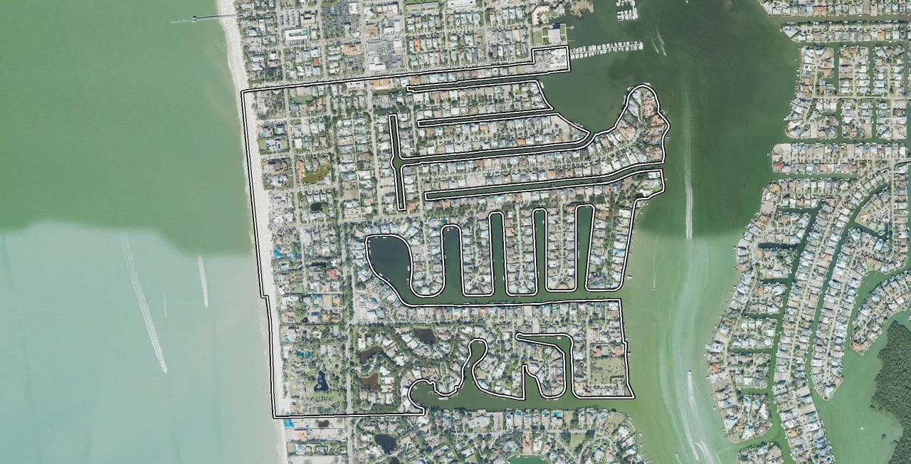
Aqualane Shores runs from the south side of 14th Avenue South to Jamaica Channel, the canal that separates it from Port Royal, and from the Gulf of Mexico to Naples Bay. The seven recorded Aqualane Shores plats cover the canal grid east of Gordon Drive and 3rd Street South; the City of Naples’ own neighborhood map adds the Gulf-front and Gordon Drive lots to the west and Little Harbour to the south, for about 300 acres including canals and streets. The association describes the same ground more simply, as the neighborhood “between Port Royal and Old Naples.”
North of 14th Avenue South the grid becomes Olde Naples, the City’s original town plat, and Third Street South’s shops begin a few blocks up. South of Jamaica Channel is Port Royal, a separately platted neighborhood with its own club; the two share a history of land but not a boundary, a deed history or an association.
Aqualane Shores has always been City of Naples ground. Every parcel on the seven plats carries ZIP 34102 on Collier County’s 2026 preliminary roll, and the City’s annexation history layer shows the neighborhood was never annexed: Units 1 to 6 lie inside the 1923 Town of Naples boundary set by special act, and Unit 7 inside the 1937 extension of that boundary. That matters for a buyer in three practical ways. City police and fire answer calls here, City zoning decides what can be built, and City utilities and the City’s millage appear on the tax bill.
Aqualane Shores is three kinds of lot, and they trade as three different markets. By our frontage classification of all 557 parcels in the City’s outline, 367 parcels front a canal, 64 front open water (Naples Bay, the approaches to Gordon Pass or Jamaica Channel), 17 front the Gulf of Mexico, and 109 are dry lots with no frontage of their own. Counting houses only, the split is 315 on a canal, 53 on open water, 15 on the Gulf and 89 on interior lots, per the county’s 2026 preliminary parcel roll joined to the City’s neighborhood outline.
The canal lots are the heart of the neighborhood: the finger canals the Walkers dredged in the 1950s, most of them running east to Naples Bay, with a seawall and usually a dock at the back of each lot. The open-water lots sit on the bay edge and along Jamaica Channel, with wider views and longer exposure to wind and wave. The Gulf-side lots west of Gordon Drive and along Gulf Shore Boulevard South are a different product again: estate lots near or on the beach, most without a boat dock, which is why in the MLS figures in the next section the “interior” lots carry the highest median price rather than the lowest.
Aqualane Shores is one of the few Naples waterfront neighborhoods where the Gulf beach, a dock on the canal and a restaurant district are all within walking distance of the same house. We measured walking routes over OpenStreetMap streets from three street corners inside the neighborhood (retrieved September 24, 2026):
From three corners inside Aqualane Shores, on foot | Distance |
|---|---|
Nearest Gulf beach end | 0.17 to 0.49 mile |
Third Street South | 0.31 to 0.73 mile |
Palm Cottage | 0.53 to 0.86 mile |
The Naples Pier site | 0.67 to 0.95 mile |
Naples City Dock | 0.95 to 1.37 miles |
West end of Fifth Avenue South | 0.99 to 1.40 miles |
By car from 16th Avenue South and 4th Street South, the Pier site is about 0.6 mile and 2 minutes, and Fifth Avenue South about 1.6 miles and 5 minutes. Drive times are free-flow estimates without traffic, measured from 16th Avenue South and 4th Street South; in-season traffic is longer.
The City’s beach-parking rules reserve the 15th, 16th, 17th and 18th Avenue South beach ends for permit holders, and the permit is free to City residents and Collier County property taxpayers, per the City’s beach parking information. The City’s coastal-access map also shows walk-up beach ends at 19th and 21st Avenue South. There is no beach parking between 18th and 32nd Avenue South. For an Aqualane Shores household, that means the beach is usually a walk or a bicycle ride rather than a parking problem.
The Naples Pier is being rebuilt, per the City’s pier rebuild project page; the City gives the project’s length, about 18 months, rather than a reopening date.
Aqualane Shores has no mandatory homeowners association. Aqualane Shores Association, Inc. is a voluntary civic association: membership costs $100 a year, and it runs social events, keeps members informed about City business and speaks for the neighborhood at City Hall. It does not own the canals, dredge them, maintain seawalls or approve house plans. Seawalls are each owner’s responsibility under City code, and past canal dredging was organized by the City through a special assessment.
There is no gate across the neighborhood. The streets are public City streets, and anyone may drive, walk or cycle them. The only gate inside the City’s outline is Little Harbour’s: Little Harbour, a gated enclave off Gordon Drive, was created by City Ordinance 94-7222 in 1994 as a planned development of 34 homesites with a gatehouse, private drives, open space and a community boat dock; Collier County’s 2026 roll shows 32 homes there. Little Harbour has its own homeowners association, and a sale there works differently from a sale on the open grid.
There is no neighborhood club either. No clubhouse, pool, tennis court or marina belongs to Aqualane Shores owners as a group, and no membership comes with a deed. The clubs nearby, and who may join them, are covered later in this guide.
About six in ten Aqualane Shores houses carry Florida’s homestead exemption on the 2026 roll, the county’s proxy for a primary residence, per the county’s parcel roll service. The rest are not claimed as a Florida primary residence on the roll.
The 2020 Census blocks that lie mostly inside the City’s Aqualane Shores outline counted about 725 residents in 535 housing units; 157 of those units were held for seasonal or occasional use, and nearly every occupied home was owner-occupied, per the Census Bureau’s 2020 Demographic and Housing Characteristics file. Census Bureau 2020 counts for the 14 blocks at least half inside the City’s outline; block counts carry the Bureau’s privacy noise.
With about four houses in ten not claimed as a primary residence, the neighborhood keeps the Naples rhythm: fuller streets in season and quieter ones in summer. The City’s construction hours and rules, which matter on a grid where about one house in five has been rebuilt in the last decade, are covered in the logistics section later in this guide.
One sound Aqualane owners do hear is aircraft. The February 2023 letter to City Council from six neighborhood associations, including Aqualane Shores’, states that a 2022 heat map “shows that aircraft, upon arrival and departure, overfly portions of Port Royal, Aqualane Shores, Old Naples, the Moorings, Royal Harbor, Gulf Shore Association of Condominiums, and Park Shore” (HOA coalition letter, February 23, 2023).
Aqualane Manor is not a separate town or a different Aqualane: it is a 12-unit condominium built in 1966 at 310 and 320 14th Avenue South, on the canal at the neighborhood’s north-west corner. It sits inside the City’s Aqualane Shores outline but on its own condominium record, with its own association, Aqualane Manor of Naples, Inc., so condominium rules and costs apply there that do not apply to the houses around it.
For buyers searching “Aqualane Manor Naples FL”, that is the whole answer: the name belongs to one small condominium, not to a neighborhood of its own, and not to the canal grid’s houses. The Southwest Florida MLS lists Aqualane Manor units under the Aqualane Shores development, which is why a condominium occasionally appears in an Aqualane Shores search; on September 24, 2026, three Aqualane Manor units were listed for sale, and none closed in the 12 months before. The condominium association does not publish its assessments; the estoppel certificate at resale states them.
A dedicated Aqualane Manor sub-page is coming with its association details, recent sale comps, and street-by-street analysis. We’ll link it here when it goes live.
A buyer comparing Aqualane Shores with a master-planned community should know what is missing as clearly as what is here. Aqualane Shores has:
The Naples Yacht Club sits on the south side of 14th Avenue South, inside the City’s outline but on the older Naples Replat rather than an Aqualane plat; it is a private club whose membership is by invitation, not a neighborhood amenity. Everything else a household uses day to day, from tennis and parks to groceries and the hospital, is a short drive north into the City, and each is covered in its own section below.
For more on what waterfront living in Aqualane Shores looks like day to day, and on the neighborhood’s quieter, residential side, see our two Aqualane Shores articles.
If you are choosing an agent for an Aqualane Shores purchase, our comparison of the best real estate agents in Naples sets out production, reviews and licence dates on the public record. When you are ready to look at specific lots, call Marc at (239) 287-5873, or read how we represent buyers in Southwest Florida.
Aqualane Shores recorded 26 single-family closings in the 12 months to September 24, 2026, totaling $259.9 million at a median of $9,075,000, or $1,772 per square foot of living area, per the Southwest Florida MLS. Homes took a median 204 days to sell, and 26 active listings equal 12 months of supply.
Data updated: September 2026 (Southwest Florida MLS, pulled 24 Sep 2026; Collier County 2026 preliminary roll, retrieved 24 Sep 2026)
In the last 12 months we tracked 26 Aqualane Shores closings, and every one of them is a single-family home. Market figures on this page come from the Southwest Florida MLS Development named Aqualane Shores, which covers the canal grid and the Gulf-side lots inside the City’s outline and lists Little Harbour separately. Every median below is the middle sale of its group; where the count is even, it is the midpoint of the two middle sales, and both are shown. Price per square foot is each sale price divided by the MLS living area, then the median of those ratios.
Closed single-family sales, September 25, 2025 to September 24, 2026 (Southwest Florida MLS, n = 26) | Aqualane Shores |
|---|---|
Closings | 26 (one of them a short sale) |
Median sale price | $9,075,000 (midpoint of $8,400,000 and $9,750,000) |
Median list price | $9,947,500 |
Median living area | 5,349 sq ft |
Median price per sq ft of living area | $1,772.02 |
Median sale-to-list ratio (n = 25 with market time recorded) | 91.21% |
Median days on market (n = 25) | 204 |
Closed at or above list price | 1 of 25 |
Total dollar volume | $259,855,000 |
Sale price range | $4,300,000 to $20,925,000 |
Price per sq ft range | $1,029.92 to $3,579.04 |
Condominium closings | 0 |
Three things stand out. First, the median buyer paid about 91 cents on the dollar of the final list price, and only one sale in 25 closed at or above list, so asking prices here are an opening position rather than a forecast. Second, the median home took 204 days to sell, which is the reason pricing and presentation matter so much here. Third, the price range is wide: the top sale, $20,925,000 in April 2026, was almost five times the lowest, $4,300,000, which is the canal-lot, bayfront and Gulf-side split showing up in the numbers.
Aqualane Shores trades as three markets, and a single neighborhood median hides the difference. Split by our frontage classification (Southwest Florida MLS, single-family closings September 25, 2025 to September 24, 2026):
Frontage (our frontage classification) | Sales (n) | Median sale price | Median price per sq ft of living area |
|---|---|---|---|
Canal-front | 20 (even) | $8,600,000 (midpoint of $7,450,000 and $9,750,000) | $1,751.63 |
Open bay or Gordon Pass frontage | 2 | two sales: $8,400,000 (December 2025) and $6,950,000 (September 2026), too few to read as a rate | not stated for two sales |
No canal or bay frontage | 4 (even) | $13,850,000 (midpoint of $12,000,000 and $15,700,000) | not shown |
Interior lots here are mostly the Gordon Drive and Gulf Shore Boulevard South estate lots near the beach, which is why they carry the highest median. A buyer who reads “interior lot” as the budget choice in Aqualane Shores has the neighborhood backwards: west of Gordon Drive, the lots without a canal are the lots nearest the Gulf.
Over five years the same order holds. In the 60 months from September 25, 2021 to September 24, 2026 (Southwest Florida MLS, single-family), canal-front homes sold 69 times at a median of $7,500,000 and $1,865.07 per square foot; open bay homes 9 times at a median of $10,900,000 and $2,641.14; interior lots 20 times at a median of $13,800,000 and $2,219.10; and one Gulf beachfront home sold, at $62,000,000 in July 2022, the highest price in the five-year window.
The median sale price rose 21 percent year over year while the median price per square foot fell about 6 percent, because the homes that sold were larger: median living area rose from 4,524 to 5,349 square feet.
Single-family closings (Southwest Florida MLS) | Prior 12 months, Sep 25, 2024 to Sep 24, 2025 | Last 12 months, Sep 25, 2025 to Sep 24, 2026 | Change |
|---|---|---|---|
Closings | 29 (odd) | 26 (even) | 3 fewer |
Median sale price | $7,500,000 | $9,075,000 | up 21.0% |
Median price per sq ft of living area | $1,878.87 | $1,772.02 | down 5.7% |
Median living area | 4,524 sq ft | 5,349 sq ft | larger homes sold |
Median days on market | 110 | 204 | slower |
Median sale-to-list ratio | 89.0% | 91.2% | closer to list |
Counting every sale in the prior 12 months, condominium included, there were 30 closings worth $289,756,531, ranging from $1,400,000 (an Aqualane Manor condominium) to $31,501,705. The honest reading of the two years together: fewer, bigger and more expensive houses sold, they took longer to sell and buyers paid slightly closer to the final list price.
Single-family closings by calendar year (Southwest Florida MLS, September 25, 2021 to September 24, 2026):
Year | Sales (n) | Median sale price | Median price per sq ft of living area |
|---|---|---|---|
2021 (September to December) | 5 | $6,285,000 | $1,765.63 |
2022 | 18 | $8,200,000 | $2,154.98 |
2023 | 13 | $8,400,000 | $2,155.17 |
2024 | 13 | $8,900,000 | $1,984.59 |
2025 | 32 | $7,125,000 | $1,982.73 |
2026 (to September 24) | 21 | $10,350,000 | $1,791.28 |
Across the full 60 months, Aqualane Shores recorded 103 closings worth $1,054,879,031, at a median of $8,400,000, $1,945.95 per square foot of living area, 115 days on market and 91.33 percent of list price (Southwest Florida MLS, n = 103). The pattern is a market that set its per-foot high in 2022 and 2023, took a volume year in 2025 at lower medians, and in 2026 has been selling larger, newer houses at the highest median sale price in the five-year record.
On September 24, 2026 the Southwest Florida MLS showed 26 single-family homes for sale in Aqualane Shores:
Active single-family listings, snapshot September 24, 2026 (Southwest Florida MLS, n = 26) | Value |
|---|---|
Median list price | $11,699,500 (midpoint of $11,499,000 and $11,900,000) |
List price range | $5,495,000 to $19,995,000 |
Median days on market so far | 136.5 |
Median living area | 5,516.5 sq ft |
Median list price per sq ft of living area | $2,265.67 |
Months of supply | 12.0 (26 actives against 26 closings a year) |
Pending | 1 |
Aqualane Manor condominiums active | 3 |
Twelve months of supply is a buyer’s market by any conventional measure, and the gap between the active median list price ($11,699,500) and the 12-month median sale price ($9,075,000) is the negotiating room that the sale-to-list ratio above keeps confirming. For a seller, that is why we price an Aqualane Shores listing for its frontage class from the first day rather than from the neighborhood median.
Little Harbour, the gated enclave inside the City’s outline, is its own MLS Development, so its sales are not in the Aqualane Shores figures above. In 60 months it recorded six closings, too few for a median, so here they are: $12,450,000 (May 2022), $7,800,000 (July 2022), $6,900,000 (March 2024), $7,000,000 (May 2024), $7,500,000 (June 2025) and $5,970,000 (April 2026). One Little Harbour home was listed for sale on September 24, 2026, at $9,900,000 (Southwest Florida MLS).
County roll figures and MLS figures measure different things. The county values every parcel as of January 1, and its values are not sale prices; the MLS records only the homes that sold, at their contract price, and measures living area rather than the county’s total area under roof. The two sets of numbers should never be compared directly.
With that caution, the county roll is still the only record that describes every lot, not just the ones that sold. On Collier County’s 2026 preliminary roll (just value, not a sale price), per the county’s parcel roll service:
The last figure is the one to remember. On the county’s own books, most of the value of an Aqualane Shores home is the lot, not the house, and that is the economics behind the rebuilding described in the section on what you can build. These are 2026 preliminary roll figures; the November 2026 tax bill is the final record.
Aqualane Shores was created by Forrest Walker and his sons, a Naples grading family who bought about 175 acres of mangrove shoreline in May 1949, dredged finger canals and pumped the spoil into buildable lots. Their company, Aqualane Shores, Inc., sold lots from late 1949 into the 1960s and was dissolved in 1963.
Most of what is known about those first years comes from an unlikely record: a federal tax case. In 1958 the United States Tax Court decided Aqualane Shores, Inc. v. Commissioner, 30 T.C. 519, and its findings of fact describe the land, the purchase, the plan and the company in more detail than any brochure. The story below is built from that opinion, the Collier County Clerk’s recorded instruments, the City of Naples’ charter and ordinances, and the City’s historic aerial photographs.
Before 1949, the land that became Aqualane Shores was bay-edge mangrove and tidal flat south of the old Naples townsite. From 1935, Philip G. and Eleanor F. Rust assembled bay-side land south of the townsite, and the Rusts’ own recorded subdivision, the Philip G. Rust Development (Plat Book 1, Page 74), had lots selling by 1940, per the Collier County Clerk’s official records index. The name survives: the Rust Development lots off Marina Drive and South Winds Drive are still recorded under it, and Aqualane Shores Unit 7 was later laid out as a re-subdivision of part of it, per the Clerk’s Unit 7 plat certificate.
The Rusts also sold land to Port Royal’s developer: a deed from Rust to Port Royal, Inc. was recorded on February 26, 1952. Both Aqualane Shores and Port Royal, in other words, were carved out of the same predecessor’s holdings, which is one reason the two names are so often confused. The Tax Court described the Walkers’ land as consisting “largely of mangrove swamps” bordered on the east by Naples Bay, and found that “practically all of this land had an elevation considerably less than the minimum of 6 feet required for residential use” (Tax Court opinion, full text).
Aqualane Shores began in 1949. That May, Forrest Walker and his sons James and Robert bought about 175 acres of mostly mangrove shoreline south of the Naples townsite, dug the first canal and sold the first 10 lots before the year was out; their company, Aqualane Shores, Inc., was chartered on December 16, 1949, according to a 1958 United States Tax Court opinion and the state’s corporate record.
The details, from the Tax Court’s findings: the three Walkers had organized a partnership on January 1, 1948 as Walker Construction Company, a landscaping and grading business that also traded as Walker Developments, with each of the three holding a one-third share. The deeds for the Rust land were dated May 14 and recorded May 31, 1949, and the price was $69,850. The partnership owned its own draglines and a dredge. In April 1950 the Walkers bought a second Rust tract, about 21.6 acres of higher ground on the west side, fronting the road down to Naples, for $44,000.
Aqualane Shores, Inc. was chartered on December 16, 1949 and organized on January 10, 1950, with 30 shares, 10 held by each Walker. Records show that a James L. Walker (1920 to 2003) served on the Collier County Commission from 1950 to 1956 and in the Florida House from 1967 to 1974, and Lorenzo Walker Technical College names him as the legislator “instrumental in obtaining original funding for the school.”
Aqualane Shores was one of the first subdivisions platted in Naples after the Second World War, and, in the Tax Court’s words, a canal-dredged plan that was “at that time a novel type of development in south and west Florida although it had been accomplished on the east coast.” The method, as the court recorded it, was the clearing of land, the dredging of canals and the pumping of fill into the land abutting the canals, so that the plan made “practically all the land waterfront property.”
The numbers in the opinion show how fast the Walkers moved. Before January 10, 1950, one canal had been dug and two and a half blocks, 27 lots, had been filled, and 10 lots had been sold in late 1949 for $20,800. In 1950 the company’s first plan laid out 302 lots, 297 of them on the water. Dredging and filling cost about $200,000, and advertising from 1950 to 1955 about $27,500. The company’s lender was the Bank of Naples, and then the Bank of Everglades by a board resolution of May 9, 1950 (Official Records Book 7, Page 90).
The City of Naples actively encouraged this kind of fill. Its Ordinance No. 400 of 1954, the Submerged Land Ordinance, recited that submerged and mangrove lands were a health and safety hazard and that their development was in the public interest, and the City’s recorded contract under that ordinance approved the Unit 6 plat and let its lots be assessed as acreage only for 10 years or until 60 percent had sold (City contract, Official Records Book 40, Page 153). Across Naples Bay as a whole, the City’s natural resources staff record that canals, seawalls and bulkheads replaced 70 percent of the bay’s fringing mangrove shoreline (City of Naples, history of oyster reefs in Naples Bay). Aqualane Shores is one of the finger-canal fills that make up that bay-wide figure; no study measures its individual share.
Aqualane Shores shares its founding year with the City of Naples itself: in June 1949 the Legislature replaced the Town of Naples, incorporated in 1923, with the City of Naples charter, and the Walkers bought the Aqualane land the month before. The charter is House Bill 1458, Chapter 26044, Laws of Florida, passed on June 13, 1949, which abolished the Town charter and created a council-manager City, per the City’s copy of the 1949 charter, the City Clerk’s history of Naples mayors and the City’s centennial history, which records that “the status of Naples was changed from a town to a city in 1949.”
The timing mattered. Within a few years of the charter, the new City was quitclaiming street strips to the Aqualane company, rezoning its blocks and contracting with it over submerged land, each step on the recorded page.
The Clerk’s index of deeds from Aqualane Shores, Inc. shows how long the sell-out took. Counting deed instruments with the corporation as grantor, per the Clerk’s official records index:
Year | Deeds from the company | Year | Deeds from the company |
|---|---|---|---|
1950 | 20 | 1958 | 11 |
1951 | 55 | 1959 | 11 |
1952 | 37 | 1960 | 5 |
1953 | 31 | 1961 | 8 |
1954 | 32 | 1962 | 5 |
1955 | 35 | 1963 | 14 |
1956 | 25 | 1964 | 9 |
1957 | 16 | 1965 to 1972 | 1 or 2 a year |
Some deeds cover several lots, so deed counts are not lot counts. Even so, the curve is clear: most of the company’s deeds were recorded between 1950 and 1955, and the last trickled out into the early 1970s. The company itself ended before its lots did. The State issued its certificate of dissolution on June 13, 1963 (Official Records Book 143, Page 413), and a recorded affidavit states that the three Walkers were its only directors and stockholders (Official Records Book 158, Page 432); the late deeds were conveyances by the Walkers as trustees after dissolution.
The City’s hand shows in the same years. In 1952 the City quitclaimed strips of Third Street to the company (Official Records Book 24, Page 410), and in 1969 Ordinance 1453 vacated part of Third Street South “and the park therein.” City Ordinance 323, adopted April 4, 1952, rezoned Unit 1 Blocks 2 and 3 to Residential “A” with a 1,100 square foot minimum house size.
The Tax Court case itself was about money, not canals. The Walker partnership sold the land to its own new corporation for $250,000, and the Internal Revenue Service successfully recast the transfer as a tax-free exchange, so the corporation’s cost basis for the lots was the partners’ original cost rather than the $250,000 price. The court decided the case on May 29, 1958, Aqualane Shores, Inc. v. Commissioner, 30 T.C. 519 (opinion).
For a buyer today, the value of the case is its findings of fact: a dated, judicial account of what the land was, what the Walkers paid, how they built it and how the lots were sold. The same opinion calls Port Royal “the ne plus ultra of Florida subdivisions,” a reminder that the two neighborhoods grew up side by side from their first decade.
The City of Naples’ historic aerial imagery shows the neighborhood being built:
About 24 years, in other words, from the first dredge to a largely finished neighborhood.
Very little of the first Aqualane Shores still stands. By year built, the houses on the seven plats break down as follows (Florida Department of Revenue 2025 statewide parcel data, 317 single-family parcels on the seven plats, via the state’s cadastral service):
Decade built | Homes | Share |
|---|---|---|
1950s | 19 | 6.0% |
1960s | 30 | 9.5% |
1970s | 23 | 7.3% |
1980s | 14 | 4.4% |
1990s | 46 | 14.5% |
2000s | 76 | 24.0% |
2010s | 75 | 23.7% |
2020 to 2024 | 34 | 10.7% |
The median year built is 2003; 58.4 percent of the houses were built in 2000 or later, and 15.5 percent before 1970. The oldest surviving house by unit dates from 1950 in Unit 1, 1952 in Unit 2, 1954 in Unit 3, 1955 in Unit 4, 1954 in Unit 5, 1955 in Unit 6 and 1970 in Unit 7. The neighborhood the Walkers sold as modest canal lots is now, for the most part, a neighborhood of houses built in the last 25 years.
For 45 years the canals had no official names. City Resolution 94-7288, adopted October 19, 1994, named them in two bird-themed series: Anhinga, Bittern, Crane, Duck, Egret and Jamaica Channels, and Spoonbill, Sanderling, Aqua, Ibis, Heron, Gull, Flamingo, Jamaica, Limpkin and Kite Coves. The same resolution bounds Jamaica Channel on the north by Aqualane Shores Unit 7 and the Rust Development and on the south by Port Royal, which makes it the recorded line between the two neighborhoods.
Aqualane Shores has no historic designation. The City’s Historic District lies north and west of the neighborhood, and none of the City’s 61 historic building footprints falls inside the seven plats. For an owner, that means no local historic designation stands between a 1950s house and its replacement; the City’s zoning code, covered in the next section, is the rulebook.
Aqualane Shores was built by a Naples family, not a corporation from away: Forrest Walker and his sons ran it first as a grading partnership and then through Aqualane Shores, Inc., which the three of them owned outright until they dissolved it in 1963, as the company’s recorded dissolution papers show. The seven plats are recorded in Collier County Plat Books 1 to 4; the Unit 6 plat was recorded on April 2, 1954 and the Unit 7 plat on March 21, 1958.
Aqualane Shores was platted in seven units recorded in Collier County Plat Books 1 to 4, from Unit 1 on 14th to 16th Avenue South to Unit 7 on Jamaica Channel in 1958. Today, what you can build is set by the City of Naples R1-10 zoning district: a 30-foot height limit measured from the flood-driven first floor.
This is the section that decides what an Aqualane Shores lot is worth. Because the county’s own roll puts most of the value in the land, most buyers here are buying the right to build, now or later, and the rules for that come from three layers of public record: the recorded plats, the City’s zoning code and FEMA’s flood map. No association sits on top of them.
Aqualane Shores was recorded as seven plats, Units 1 to 7, the first in use by 1950 and the last recorded in 1958. On Collier County’s 2026 preliminary tax roll those seven plats, with a 2010 replat inside Unit 2, hold 360 parcels: 329 homes, 19 vacant homesites and 10 lots that carry only a dock, seawall or pool. The City of Naples maps a wider Aqualane Shores neighborhood that also takes in Little Harbour, the Philip G. Rust Development lots off Marina Drive, two small condominiums on 14th Avenue South and the Gulf-side lots on Gordon Drive and Gulf Shore Boulevard South. That outline holds 557 parcels, 472 of them houses and 19 of them condominium units. When the City balloted the neighborhood in 2019, it mailed ballots to 536 property owners (City of Naples 2019 assessment ballot results).
Unit | Plat Book / Page | Recorded | What it is | Main streets | Parcels / homes (2026 roll) |
|---|---|---|---|---|---|
Unit 1 | PB 1, p 86 | in Plat Books 1 to 3, early 1950s (in use by early 1950) | the original first unit | 14th to 16th Avenue South | 69 / 61 |
Unit 2 | PB 1, p 96 | in Plat Books 1 to 3, early 1950s | bay-side blocks; includes the 2010 Kremer Estate replat (4 parcels, 4 homes) | 17th and 18th Avenue South, Aqua Circle | 80 / 76 |
Unit 3 | PB 2, p 98 | in Plat Books 1 to 3, early 1950s | the west side | 3rd Street South, Gordon Drive | 44 / 39 |
Unit 4 | PB 3, p 2 | in Plat Books 1 to 3, early 1950s | the southern canal blocks | 18th to 21st Avenue South, Aqua Court, Gordon Drive East | 58 / 56 |
Unit 5 | PB 4, p 11 | in Plat Book 4 | a small unit | 21st Court South | 5 / 4 |
Unit 6 | PB 3, p 20 | April 2, 1954 | a resubdivision of undivided Block A of Unit 4 | 5th to 8th Street South | 76 / 65 |
Unit 7 | PB 4, p 59 | March 21, 1958 | a re-subdivision of Blocks 3 and 4 and part of Block 5 of the Philip G. Rust Development | Forrest Lane, Marina Drive, 21st Avenue South | 24 / 24 |
Sources: the Clerk’s Unit 6 plat certificate and 1995 Unit 6 certificate; the Unit 7 plat certificate; City Resolution 10-12799 (the 2010 replat); City Ordinance 1453 and Resolutions 13-13226 and 13-13227, which cite the plats by book and page; the Laws of Florida special-act list; and Collier County’s 2026 preliminary roll for the parcel and home counts. The seven plats are recorded in Collier County Plat Books 1 to 4; the Unit 6 plat was recorded on April 2, 1954 and the Unit 7 plat on March 21, 1958.
The unit number matters less to a buyer than it once did. The Southwest Florida MLS never splits sales by unit, one voluntary association covers all seven, and one set of City rules applies across them. What the unit does tell you is the lot’s lineage: which plat’s lot lines, easements and original restrictions sit in its chain of title.
The street grid inside the City’s outline takes in 14th to 18th Avenue South, 20th and 21st Avenue South, 21st Court South, 3rd Street South, 4th to 8th Street South, Aqua Circle, Aqua Court, Gordon Drive and Gordon Drive East, Gulf Shore Boulevard South, Forrest Lane, Marina Drive, South Winds Drive, Jamaica Lane, Little Harbour Lane and Shell Alley, per the City’s neighborhood outline and the county’s site address points.
The avenues run east-west between the canals, most of them ending at the water; the numbered streets run north-south, and Gordon Drive is the spine that carries through traffic south toward Port Royal. The canals between the avenues carry the names the City gave them in 1994, from Anhinga Channel in the north to Jamaica Channel on the Port Royal line, with the coves of Unit 6 and Unit 7 branching off them. Street names are what a buyer will search; canal names are what a boater, a dock contractor and a City permit will use.
About four in five parcels in the City’s outline are zoned R1-10, the City’s single-family district, per the City’s zoning layer. The standards, from the City’s R1-10 code, Secs. 58-171 to 58-180:
R1-10 standard | Requirement |
|---|---|
Use | single-family dwellings |
Minimum lot area | 10,000 sq ft |
Minimum lot width | 75 ft interior, 87.5 ft corner |
Front yard | 30 ft |
Side yard | 7.5 ft for the first 15 ft of height, then a 12:12 slope (Ord. 24-15381, June 5, 2024) |
Rear yard | 25 ft |
Maximum height | 30 ft, measured from the flood-driven base described below (Ord. 24-15349, April 3, 2024) |
Minimum floor area | 1,200 sq ft one-story, 1,600 sq ft two-story |
Parking | one space within the building area |
The City also caps building coverage in Sec. 58-180; the percentage table should be read in the current code before a design is drawn.
Not every parcel inside the outline is R1-10. Little Harbour and Palmer Estates (Ordinance 19-14366) are planned developments with their own approved plans; some lots are zoned R1-7.5 or R1-15; the condominiums on 14th Avenue South are R3-12; there is one C1 commercial parcel on 14th Avenue South; and the Naples Yacht Club is zoned PS. The zoning layer, not the plat, is the first document to check for any specific lot.
The floor-area minimum has an ancestor. The City’s 1952 Ordinance 323 set a 1,100 square foot minimum house when it rezoned part of Unit 1; today’s 1,200 and 1,600 square foot minimums follow the same idea, and the lineage is our reading of the two texts.
In Aqualane Shores, the 30-foot height limit does not start at the ground. Under the R1-10 code as amended by Ordinance 24-15349 on April 3, 2024, height is measured from the greatest of four bases: the Florida Building Code’s required lowest floor elevation, the state DEP elevation plus 18 inches, the average road crown plus 18 inches, or the average natural grade. An owner may use the floor required by the May 16, 2012 FIRM if that is higher (R1-10 code).
On FEMA’s current flood map, effective February 8, 2024, 95 percent of Aqualane Shores parcels sit in Zone AE with a base flood elevation of 8 or 9 feet (NAVD88), per FEMA’s National Flood Hazard Layer. The City’s design flood elevation is the base flood elevation plus one foot (City flood mitigation guidelines). On a lot in AE 9, then, the first floor of a new house starts at least 10 feet above the vertical datum, and the 30 feet of permitted height are counted from there. That is why new Aqualane houses stand visibly taller than the 1950s houses beside them, and why a lot’s flood zone and base flood elevation are part of its price. Street-by-street flood detail is in the flood-zone section of this guide.
Since Ordinance 24-15381 of June 5, 2024, an R1-10 house must stay 7.5 feet from each side line for its first 15 feet of height, and above that the permitted envelope slopes inward at 12:12, one foot in for every foot up (R1-10 code). On a typical Aqualane lot that rule, more than the 30-foot cap, shapes the second story: the upper floor steps back from the neighbors, which keeps light between houses on lots that are often narrower than the new houses would like to be. Plans drawn before June 2024 may not meet it, which is worth checking on any lot sold with a design already attached.
The only recorded restriction indexed to Aqualane Shores covers part of Unit 1; a title search on a specific lot shows what, if anything, still applies to it. That instrument, Deed Book 18, Pages 333 to 337, recorded in February 1951, covers Block 1 Lots 6 to 11 and the 14th Avenue South plots. As a historical document it describes the neighborhood the Walkers intended: one detached single-family dwelling of not more than two stories with a garage for not more than two cars, a $7,000 minimum cost, an 850 square foot minimum ground floor, a 90-foot and 12,000 square foot minimum lot, boat slips capped at 35 by 14 feet, no houseboats and no oil drilling, for a 25-year term with automatic 10-year renewals.
No recorded declaration binds Aqualane Shores lots to a homeowners association; today, what can be built on a lot is set by City of Naples zoning. Whether any of the 1951 terms still bind a given Unit 1 lot is a title question for that lot, not something a neighborhood guide can answer.
A lot’s dock rights are part of what you can build, and Aqualane Shores has its own paragraph in the City’s dock code. A pier may reach no more than 15 feet or 10 percent of the waterway’s width, whichever is smaller; a boat lift, or a pier and lift together, no more than 25 feet or 25 percent; and piers, lifts and boats must stay 7.5 feet from the side property lines (City Code Sec. 56-93(c)(1)). The practical effect is that a narrow canal allows a short dock, whatever the lot’s price; the boating section of this guide covers the rule’s history and what it means on the water.
On Collier County’s 2026 preliminary roll (just value, not a sale price), the median land just value is $5.05 million per homesite on the seven plats, about $15.4 million per acre, and improvements are a median 20 percent of a parcel’s total value, per the county’s parcel roll service. The median homesite on the plats is 0.32 acre, with a range of 0.23 to 1.12 acres.
The roll also shows how many lots are between houses. Nineteen parcels on the seven plats carry land value and no improvement value, and 29 homesites have no house at all, either vacant or carrying only a dock. Only 7 of the 329 houses on the plats carry an improvement value under $250,000. In plain terms: on the county’s books an older Aqualane house adds little to what its lot is worth, which is why buyers of older homes here usually price the lot and treat the house as a place to live while they plan, or as a demolition line in the budget. These are 2026 preliminary roll figures; the November 2026 tax bill is the final record.
Our comparison of Collier County’s 2015 and 2025 building-footprint maps finds that about one house in five on the seven plats was rebuilt or substantially enlarged in that decade (county building footprints, 2015 vs 2025; a main footprint overlapping its 2015 outline by less than 60 percent counts as rebuilt or enlarged), per the county’s building footprint service. Put that beside the year-built table in the history section, where more than half the houses date from 2000 or later, and the picture is a neighborhood in steady, lot-by-lot replacement rather than one waiting for a single wave of redevelopment. For a buyer that means construction nearby is normal, and for a seller of an older house it means the buyer on the other side of the table is often a builder or a client with an architect.
City Council adopted Ordinance 2023-15041 on February 1, 2023 (Text Amendment 22-T8), setting rules for combining single-family lots, per the City’s 2023 voting record. Council has also granted elevation-driven relief case by case: in 2026 it approved a 7.5-foot front-yard encroachment for egress stairs when an existing R1-10 home was being elevated (Resolution 2026-15905), and expansions of nonconforming houses go to Council, as in a 2026 South Winds Drive case approved 7-0 (Resolution 2026-15797), per the City’s 2026 voting record.
On design, the City is explicit: “Single family zoning districts are not subject to design review,” and its Design Review Board covers commercial, multifamily, planned development and public service projects instead (Design Review Board). With no association architectural committee either, an Aqualane Shores house that meets the zoning, flood and building codes needs no one’s aesthetic approval, which is the freedom and the risk of buying on an open grid: the house next door answers to the same code, not to a style guide.
In the last 12 months, 26 Aqualane Shores homes sold for a combined $259.9 million, and the canal, bayfront and Gulf-side lots traded as three different markets. McGreevy and Comisar are Top 1% Real Estate Agents Nationally Since 2008, and we price every Aqualane lot from its plat, its flood zone and its dock rights before we price the house on it. Selling? Get a free Aqualane Shores home valuation, or call Jesse direct at (239) 898-6072. Buying? Call Marc at (239) 287-5873, or read how we represent buyers in Southwest Florida.
Our guide to selling a home in Aqualane Shores covers pricing, marketing and the costs of a sale.
Aqualane Shores is governed by the City of Naples, not by a homeowners association. City Council, the City code and City staff set the zoning, dock, seawall, flood and rental rules. Aqualane Shores Association, Inc. is a voluntary civic group at $100 a year, and only Little Harbour and Aqualane Manor have associations of their own.
That one fact changes how a purchase here works. There is no architectural review committee to approve a new house, no estoppel certificate for a plat lot, no transfer fee to a master association and no board that can levy a special assessment on your lot. The rules a buyer lives under are public law, and they are written down in the City of Naples Code of Ordinances, the City’s zoning map and the recorded plats.
Every parcel in Aqualane Shores sits inside the incorporated City of Naples and carries the City’s operating millage on Collier County’s 2026 preliminary tax roll. The City’s zoning code decides what may be built on a lot, the City’s dock code decides how far a pier may reach into a canal, the City’s seawall code decides how high a new cap may go, and the City’s building department administers the flood rules that set how high a new floor must sit.
Naples is run by a City Council of seven members, each elected at large for a four-year term and limited to two consecutive terms. There is no ward or district seat for Aqualane Shores; every council member answers to the whole city. Council adopts the millage each September, decides variances and conditional uses, and approves the special assessments described below.
Fire and emergency medical calls are answered by Naples Fire-Rescue, the City’s own department, and the neighborhood lies inside the City fire district on the county’s fire district map. At the county level, Aqualane Shores falls in Collier County Commission District 4 on the county’s commissioner district map, which matters for county services such as beach renourishment, the tourist development tax and the county’s share of the tax bill.
Aqualane Shores has no mandatory homeowners association, whatever some listings call it. The neighborhood dates from 1949; its civic association, Aqualane Shores Association, Inc., was incorporated as a Florida not-for-profit on February 3, 1966, and is active today, per the Florida Division of Corporations (document 710300). The state record shows an involuntary dissolution on November 1, 1985 and a reinstatement on March 10, 1986, and an annual report filed every year from 1995 through 2026.
Aqualane Shores Association, Inc. is a voluntary civic association: membership costs $100 a year, and it runs social events, keeps members informed about City business and speaks for the neighborhood at City Hall. The association’s membership page invites residents to “join the Aqualane Shores Association for a low annual fee of $100”, and its home page carries the tagline “The Friendliest Neighborhood in Naples.”
The association’s website lists a Naples post office box on its contact page; since March 2026 its state filings list a property-management company, Gordon Pass Property Management, as registered agent. The association’s bylaws and minutes are shared with members; membership is open to residents for $100 a year.
The association states its mission on its About page: “to promote a sense of community; to provide access to the City of Naples on matters of interest; to communicate matters that may affect the community; to support the safety of community members; to recommend/support initiatives that benefit the greater good of the community.”
In practice that means a working line to City Hall. The association’s president sits on the City Manager’s monthly President’s Council of homeowner-association heads, the Chief of Police or the City Manager attends the association’s monthly board meetings, and a City Community Police Officer patrols the neighborhood and attends as well, per the association’s member benefits page. The association lists the projects it championed: natural gas lines, fiber optic internet, the entrance signage and crosswalk signals. In February 2023 it joined five other neighborhood associations in a coalition letter to City Council on airport overflights.
What it does not do is just as important for a buyer. It does not own the canals, dredge them, maintain seawalls or approve house plans. Seawalls are each owner’s responsibility under City code: Sec. 52-92 makes a failed seawall “unlawful and a public nuisance.” Past canal dredging was organized by the City through a special assessment, not by the association. No recorded declaration binds the plat lots to the association, and the association holds no lien right over any lot.
The City code gives the association exactly one formal role. When an owner on an undulating or dead-end shoreline asks for an exception to the dock rules, the City Manager consults “the subdivision property owners’ association, if applicable,” under Sec. 56-93(d). That is a consultation, not a veto.
Little Harbour, a gated enclave off Gordon Drive, was created by City Ordinance 94-7222 in 1994 as a planned development of 34 homesites with a gatehouse, private drives, open space and a community boat dock; Collier County’s 2026 roll shows 32 homes there. Little Harbour has its own homeowners association, listed with the Florida Division of Corporations; its dues are not published.
Little Harbour’s association does not publish its dues; the declaration recorded for the enclave and the association’s estoppel certificate at resale state them. Inside the gate, the private drives, the gatehouse and the common tracts are the association’s, which is the opposite of the rest of Aqualane Shores, where the streets are City streets and the canals are public waterways.
A dedicated Little Harbour sub-page is coming with its association details, recent sale comps, and street-by-street analysis. We’ll link it here when it goes live.
Aqualane Manor, the 12-unit condominium on 14th Avenue South, is run by its own association, Aqualane Manor of Naples, Inc., which the Florida Division of Corporations lists as active (document 710844). The condominium association does not publish its assessments; the estoppel certificate at resale states them.
Florida’s condominium milestone-inspection statute, F.S. 553.899, applies to buildings of “three habitable stories or more” held in condominium or cooperative ownership. We have not verified the story count of the Aqualane Manor buildings, so a buyer should read the association’s own inspection and reserve records in the condominium documents rather than assume either way.
Aqualane Shores has no community development district, the special taxing district that funds roads, lakes and utilities in many newer Collier County communities. The county’s community development district layer holds 33 districts, and none of them intersects Aqualane Shores. There is no district bond, no district operations charge and no district board. The streets and drainage are City infrastructure, and the special assessments below show how the City has paid for shared improvements instead.
When Aqualane Shores has paid for a shared improvement, the City, not an association, has run the process as a special assessment, with a public hearing and a ballot or survey of owners.
The 2019 gas and fiber line extension. The Aqualane Shores Utility Line Extension brought natural gas and fiber optic lines to the neighborhood. It was requested by the association “(including Little Harbour)”, and the City’s Finance Department mailed ballots to 536 property owners, per the City’s special assessments page, its 2019 owner letter and the ballot results. Resolution 2019-14327 set the total capital cost at $1,360,840. The per-home amounts are in the fee stack section below.
The 2001 to 2005 canal dredging assessment. In February 2001 City Council began the process for dredging the Aqualane canals by Resolution 01-9095, per the minutes of February 21, 2001. The City returned to it in a 2004 workshop, and in May 2005 Council approved Resolution 05-10819 after a mailed survey of canal owners, with a 55 percent approval threshold, per the 2005 minutes. Whether that project was completed, and to what depth, is not in the public records we reviewed.
The 2024 undergrounding study. In February 2024 City Council approved Resolution 2024-15309, 6-0, for a Kimley-Horn feasibility study of burying overhead power lines in Port Royal, Aqualane Shores and Royal Harbor, per the City’s action report. The study was advance-funded by the City, to be repaid by the neighborhoods if no assessment follows. No undergrounding assessment for Aqualane Shores had been adopted as of September 2026. The study’s results had not been presented as an Aqualane assessment as of September 2026.
What is not Aqualane’s. Aqualane Shores is not in the City’s East Naples Bay or Moorings Bay taxing districts, which fund dredging elsewhere on the water. The Port Royal Area Dredging assessment (Resolutions 11-12978 and 11-13008) listed on the City’s special assessments page belongs to Port Royal, not to Aqualane Shores.
Three City bodies touch an Aqualane Shores property, and a buyer planning work should know which is which. The Design Review Board does not review single-family houses, so a new Aqualane house goes to the City’s building and zoning staff rather than to a design panel. The Planning Advisory Board hears rezonings and variances and sends a recommendation to City Council. City Council decides dock variances itself: in 2016 it denied a request for an Aqualane dock extending 32 feet into the waterway by Resolution 16-13769.
Body | What it decides for an Aqualane Shores owner |
|---|---|
City Council | Millage, variances, dock variances, conditional uses, special assessments |
Planning Advisory Board | Recommendations on rezonings and variances |
Design Review Board | Does not review single-family houses |
City building and zoning staff | Permits, flood elevation, setbacks, dock and seawall permits |
Collier County Commission (District 4) | County services and the county share of the tax bill |
Collier County School Board | School millage and school zoning |
Aqualane Shores Association | No regulatory power; voluntary civic group |
Owning an Aqualane Shores house means paying Collier County property tax at 9.0076 mills on the 2026 preliminary roll, City of Naples utility charges billed every two months, and optional $100 association dues. There is no mandatory HOA fee, no community development district and no club dues; Little Harbour and Aqualane Manor add association fees that are not published.
Data updated: September 2026 (Collier County 2026 preliminary roll; City of Naples 2026 utility rates; association website, retrieved 24 Sep 2026)
The Aqualane Shores fee stack is short compared with a gated master-planned community, but the property tax line is large, because it is levied on the value of waterfront land inside the City of Naples. The figures below are Collier County’s 2026 preliminary roll figures, which are assessments for tax purposes and not a sale price, and the City of Naples rate sheet effective October 1, 2025.
Layer | Amount | Period | What it covers | Source (as of) |
|---|---|---|---|---|
Collier County | 3.2449 mills (General Fund 3.0107, Water Pollution Control 0.0246, Conservation Collier 0.2096) | Annual, November tax bill | Countywide services, sheriff, parks, land conservation | ParcelJoin (2026 preliminary); Naples Press |
Collier County School Board | 4.1470 mills | Annual | Public schools | ParcelJoin (2026 preliminary) |
City of Naples | 1.2900 mills (up from 1.23) | Annual | Police, fire, parks, planning | ParcelJoin; Gulfshore Business (September 2026) |
Water management and mosquito control districts | 0.3257 mills combined | Annual | South Florida Water Management District, its Big Cypress Basin, Collier Mosquito Control District | ParcelJoin (2026 preliminary) |
Non-ad-valorem assessments | $0 on every parcel on the 2026 preliminary roll | n/a | n/a | ParcelJoin (final bill November 2026) |
Stormwater utility | $49.56 per single-family home | Every two months (from October 1, 2025) | City drainage system | City of Naples 2026 utility rates; increases reported by Gulfshore Business and Naples Press |
Solid waste (garbage $39.14, horticulture $12.68, recycling $8.96, county disposal $16.30) | $77.08 | Per billing cycle | Trash, yard waste, recycling | |
Water | Base $21.48 (5/8 to 3/4 inch meter) plus $1.86, $3.25, $4.62 or $5.55 per 1,000 gallons by block | Every two months | Potable water | |
Sewer | Base $53.76 plus $5.21 per 1,000 gallons, capped at 20,000 gallons for a single-family home | Every two months | Wastewater | |
Aqualane Shores Association | $100 | Annual, voluntary | Membership, events, City liaison | Association (September 2026) |
Little Harbour homeowners association (Little Harbour lots only) | Not published | Not published | Gatehouse, private drives, common tracts, dock facility | Estoppel certificate at resale |
Aqualane Manor condominium association (12 units only) | Not published | Not published | The condominium | Estoppel certificate at resale |
Community development district | None | n/a | n/a | |
Club dues | None bundled with any home | n/a | n/a | No club parcel or club covenant on the plats |
Beach renourishment | $0 to owners (funded by the tourist development tax) | n/a | n/a | |
Flood and wind insurance | Quoted house by house | Annual | See the insurance section | No public record of a typical premium |
Premiums are quoted house by house; no public record gives a typical figure. Little Harbour’s association does not publish its dues; the declaration recorded for the enclave and the association’s estoppel certificate at resale state them. The condominium association does not publish its assessments; the estoppel certificate at resale states them.
On Collier County’s 2026 preliminary tax roll, every Aqualane Shores parcel is taxed at 9.0076 mills, about $9,008 for every $1 million of taxable value, per the county’s ParcelJoin service. The rate is the same on a canal lot, a bayfront lot and a Gulf-side estate, because the whole neighborhood sits in one taxing area inside the City.
The City of Naples raised its operating millage from 1.23 to 1.29 mills for fiscal 2026-27, adopted on September 16, 2026, as reported by Gulfshore Business; the 2026 preliminary roll already carries 1.29. The water management and mosquito control line, 0.3257 mills, is the South Florida Water Management District, its Big Cypress Basin and Collier Mosquito Control District combined.
Where a single-family owner’s tax dollar goes, on our arithmetic from the roll: schools about 47 cents, the County about 36 cents, the City about 14 cents and the other districts about 4 cents, which matches the “14 cents … 47 cents … 36 cents … 4 cents” split the City gave when Council approved the rate, as reported by Gulfshore Business. The City’s own levy is the smallest of the three large ones.
The median single-family bill is $49,353 on the seven Aqualane plats and $50,709 across the City’s wider outline, on Collier County’s 2026 preliminary roll. Homestead matters: inside the City’s association map, homesteaded houses have a median bill of $39,779 and non-homesteaded houses $64,898. The middle half of single-family bills inside that association map runs from $30,694 to $72,236.
By plat, the 2026 preliminary single-family medians run from about $40,000 to about $62,500:
Plat | Median single-family 2026 preliminary tax bill |
|---|---|
Aqualane Shores Unit 1 | $40,239 |
Aqualane Shores Unit 2 | $40,843 |
Aqualane Shores Unit 3 | $48,979 |
Aqualane Shores Unit 4 | $62,534 |
Aqualane Shores Unit 6 | $51,614 |
Aqualane Shores Unit 7 | $51,820 |
Unit 5, with four houses, is left out. These are 2026 preliminary roll figures; the November 2026 tax bill is the final record. A bill tracks the county’s taxable value, not a sale price, and on a house that last changed hands years ago the gap between the two can be very large, which is the subject of the next section.
About six in ten Aqualane Shores houses carry Florida’s homestead exemption on the 2026 roll, the county’s proxy for a primary residence. A homestead owner gets the $25,000 exemption under F.S. 196.031 plus the additional exemption against non-school levies, which appears as $26,411 on the Aqualane roll.
The bigger number is the Save Our Homes cap. Under F.S. 193.155(1), a homestead’s assessed value may grow each year by no more than 3 percent or the change in the consumer price index, whichever is lower. Under 193.155(3), a change of ownership resets the assessed value to just value as of the next January 1. On the 2026 preliminary roll, the median gap between just value and capped assessed value on homesteaded Aqualane houses is $2.41 million of assessed value, per the county roll.
A buyer’s first tax bill is computed on the full just value, not the seller’s capped value, which is why two neighbors on one street can pay bills tens of thousands of dollars apart. The medians above show it: $39,779 for homesteaded houses against $64,898 for the rest, a gap of more than $25,000. When we price an Aqualane purchase for a buyer, we estimate the post-sale bill on the reset value, never on the seller’s last bill.
The City of Naples bills water, sewer, trash and stormwater on one utility account, every two months, at the rates in the City of Naples 2026 utility rates, effective October 1, 2025.
The stormwater charge is the one to watch. Aqualane Shores lies in the City’s Basin IV drainage basin, and the stormwater utility is what pays for the drainage studies and projects the City runs there.
The 2019 Aqualane Shores Utility Line Extension is the one special assessment an Aqualane buyer is likely to hear about. Under Resolution 2019-14327, a single-family home paid $2,712 one time, or $747 a year for four years, for gas and fiber; a home taking fiber only paid $627, or $172 a year; condominium units paid $678, or $187 a year. The first installment appeared on the November 2020 tax bill, per the City’s special assessments page.
Collier County’s 2026 preliminary roll shows no non-ad-valorem assessment on any Aqualane Shores parcel. These are 2026 preliminary roll figures; the November 2026 tax bill is the final record, and the seller’s last paid tax bill is the document to read at contract.
The absences on this list are worth money. Aqualane Shores has:
What an owner does pay for privately is the lot’s own waterfront: the seawall, the dock and the boat lift are each owner’s responsibility under City code, and their permits are covered in the boating section.
A statewide homestead amendment on the November 2026 ballot “would increase nonschool property tax exemptions for primary homes from $25,000 to $150,000 in 2027 and $250,000 in 2028,” as reported by Gulfshore Business, and the City cited it when it set its 1.29 mill rate. The outcome is for voters; we make no prediction. For an Aqualane Shores homeowner, the question matters only to the homesteaded six in ten, and it does not change the reset a buyer’s value takes at purchase.
Selling? Get a free Aqualane Shores home valuation, or Call Jesse direct at (239) 898-6072.
Aqualane Shores is made up of seven recorded Aqualane plats, three neighboring plats the City’s dock code treats as part of Aqualane, and a strip of Gulf-side lots the City maps with it, for 557 parcels in all. Two pockets differ on the record: Little Harbour, a gated planned development, and Aqualane Manor, a 12-unit condominium.
Data updated: September 2026 (Collier County 2026 preliminary roll; Southwest Florida MLS, 60 months to 24 Sep 2026)
The parcel counts below come from Collier County’s 2026 preliminary roll, read against the City of Naples’ own Aqualane Shores neighborhood outline; the roll’s values are assessments, not a sale price. Frontage is by our frontage classification, which sorts every parcel as canal-front, open water (Naples Bay, the Gordon Pass approaches and Jamaica Channel), Gulf-front or a dry interior lot from the City’s water layers. Sales are Southwest Florida MLS closings over the 60 months from September 25, 2021 to September 24, 2026.
Group | Plat or record | Streets | Parcels (houses) | Frontage mix | MLS closings, 60 months |
|---|---|---|---|---|---|
Unit 1 | Plat Book 1, Page 86 | 14th to 16th Ave S, 4th St S | 69 (61) | 66 canal, 3 open water | 19 |
Unit 2, with The Kremer Estate replat (2010) | Plat Book 1, Page 96 | 17th and 18th Ave S, Aqua Cir | 80 (76), plus 4 (4) in the replat | 66 canal, 14 open water; replat 2 canal, 2 open water | 17, plus 1 in the replat ($18,000,000, June 2025) |
Unit 3 | Plat Book 2, Page 98 | 3rd St S, Gordon Dr, 4th St S | 44 (39) | 21 canal, 23 interior | 15 |
Unit 4 | Plat Book 3, Page 2 | 18th to 21st Ave S, Aqua Ct, Gordon Dr E | 58 (56) | 53 canal, 5 interior | 13 |
Unit 5 | Plat Book 4, Page 11 | 21st Ct S | 5 (4) | 3 canal, 2 open water | 0 |
Unit 6 | Plat Book 3, Page 20 (1954) | 5th to 8th St S | 76 (65) | 68 canal, 8 open water | 12 |
Unit 7 | Plat Book 4, Page 59 (1958) | Forrest Ln, Marina Dr, 21st Ave S | 24 (24) | 20 canal, 4 open water | 7 |
Philip G. Rust Development | Plat Book 1, Page 74 | S Winds Dr, Marina Dr, Jamaica Ln | 20 (17) | 18 open water, 2 interior | 1 ($11,250,000, December 2021) |
Marina Shores Replat, Kluck Subdivision and the Ryan lots | Marina Shores and Kluck named in City Code Sec. 56-93 | 21st Ct S, Marina Dr, Jamaica Ln | 13 (7) | 3 canal, 5 open water, 5 interior | 2 (Marina Shores: $3,250,000, January 2025; $8,400,000, December 2025) |
Gulf-side lots: Plan of Naples Tiers 1 to 4, Gulf Heights, Oasis on the Gulf, Sagamore Beach Replat, Palmer Estates | Plan of Naples, Plat Book 1, Page 8; the others by name | Gulf Shore Blvd S, Gordon Dr, 14th to 20th Ave S | 88 (79) | 17 Gulf, 8 canal, 63 interior | 10 (including the $62,000,000 Gulf-front sale, July 2022) |
14th Avenue South edge: Naples Replat (with the Naples Yacht Club parcel) and Pettit Square (7 condominium units) | Naples Replat | 14th and 15th Ave S | 17 (8 houses, plus 7 condominium units) | 9 canal, 1 open water, 7 interior | 2 ($14,750,000, May 2023; $4,500,000, March 2024) |
Little Harbour | Planned development, Ordinance 94-7222 (1994) | Little Harbour Ln, gate on Gordon Dr | 47 (32 homes, plus 15 common and submerged tracts) | 36 canal or lagoon, 7 open water, 4 interior | Its own MLS Development: 6 (listed below) |
Aqualane Manor (condominium) | Condominium, 1966 | 14th Ave S | 12 units | 12 canal | 1 ($1,400,000, May 2025) |
Total, City outline | 557 (472 houses, plus 19 condominium units) | 367 canal, 64 open water, 17 Gulf, 109 interior | 103 in the Aqualane Shores MLS Development (3 not matched to a parcel by address), plus 6 in Little Harbour |
Aqualane Shores was recorded as seven plats, Units 1 to 7, the first in use by 1950 and the last recorded in 1958. On Collier County’s 2026 preliminary tax roll those seven plats, with a 2010 replat inside Unit 2, hold 360 parcels: 329 homes, 19 vacant homesites and 10 lots that carry only a dock, seawall or pool. The City of Naples maps a wider Aqualane Shores neighborhood that also takes in Little Harbour, the Philip G. Rust Development lots off Marina Drive, two small condominiums on 14th Avenue South and the Gulf-side lots on Gordon Drive and Gulf Shore Boulevard South. That outline holds 557 parcels, 472 of them houses and 19 of them condominium units. When the City balloted the neighborhood in 2019, it mailed ballots to 536 property owners.
The seven plats are recorded in Collier County Plat Books 1 to 4; the Unit 6 plat was recorded on April 2, 1954 and the Unit 7 plat on March 21, 1958, per the Clerk’s certificates for Unit 6 and Unit 7. Unit 1 was in use by early 1950 (the first lot deeds are recorded in March 1950).
The State of Florida’s own list of “ALL CANALS OF AQUALANE SHORES”, in the special act codified with the City’s charter as Laws of Florida chapter 92-258, lists canal entrances for the Rust Development and Units 1, 2, 4, 5, 6 and 7, and none for Unit 3, which fits Unit 3’s mostly dry lots.
The City’s dock code defines the neighborhood more widely than the seven plats. Its Aqualane paragraph applies to “Aqualane Shores, including Phillip G. Rust Development, Elliott Subdivision, Marina Shores Replat, and Kluck Subdivision,” in City Code Sec. 56-93(c)(1). Elliott Subdivision has no parcel on today’s roll, so in practice the dock-code Aqualane is the seven plats plus the Rust, Marina Shores and Kluck lots: 387 parcels.
The Philip G. Rust Development (Plat Book 1, Page 74) is older than Aqualane Shores, and Unit 7 was later carved out of its blocks. Its 20 parcels sit on South Winds Drive, Marina Drive and Jamaica Lane, and 18 of them face open water, the bay and Jamaica Channel. In 60 months the Southwest Florida MLS recorded one Rust Development closing, at $11,250,000 in December 2021.
Marina Shores Replat (six houses on 21st Court South and Marina Drive), the single Kluck Subdivision parcel on Marina Drive and six Ryan Subdivision lots (four vacant, two carrying only a dock or seawall) make up the last 13 parcels of this corner. Marina Shores recorded two MLS closings in 60 months: $3,250,000 in January 2025 and $8,400,000 in December 2025.
Canal lots are Aqualane Shores’ main product: 367 of the 557 parcels in the City’s outline, and 315 of its 472 houses, back onto one of the dredged finger canals, by our frontage classification. They fill Units 1, 2, 4, 6 and 7, on the canals the City named in 1994 (see the boating section).
In the 12 months to September 24, 2026, canal-front houses made up 20 of the 26 single-family closings, at a median of $8,600,000 (the middle pair $7,450,000 and $9,750,000) and $1,752 per square foot of living area, per the Southwest Florida MLS. Over 60 months, 69 canal-front houses sold at a median of $7,500,000 and $1,865 per square foot. A canal lot’s value turns on things the median cannot show: the width of the canal in front of it, the distance to the bay, the state of the seawall and what the dock code lets the owner build.
Sixty-four parcels, 53 of them houses, face open water rather than a canal, by our frontage classification: the east ends of 17th and 18th Avenue South and Aqua Circle on Naples Bay, the bay side of 8th Street South, and Forrest Lane, South Winds Drive and Marina Drive on the Gordon Pass approaches and Jamaica Channel.
Open-water sales are few. In the 12 months to September 24, 2026, the Southwest Florida MLS recorded two: $8,400,000 in December 2025 and $6,950,000 in September 2026. Over 60 months, nine open-water houses sold at a median of $10,900,000 and $2,641 per square foot of living area, the highest price per foot of any frontage class with more than one sale. Wide water and a short run to Gordon Pass are what a buyer pays for here.
Seventeen parcels, 15 of them houses, sit on the Gulf of Mexico, by our frontage classification: lots on Gulf Shore Boulevard South, on Gordon Drive and at the Gulf ends of 14th to 18th Avenue South. They belong to the older plats the City’s outline takes in: the Plan of Naples (Plat Book 1, Page 8, the original town plat), Gulf Heights, Oasis on the Gulf, Sagamore Beach Replat and Palmer Estates. None of them is on an Aqualane unit plat. The one Gulf beachfront sale in the Aqualane Shores MLS Development in 60 months closed at $62,000,000 in July 2022.
Another 109 parcels, 89 of them houses, are dry lots with no water frontage, mostly on the west side of 3rd Street South and both sides of Gordon Drive. Interior lots here are mostly the Gordon Drive and Gulf Shore Boulevard South estate lots near the beach, which is why they carry the highest median. In the 12 months to September 24, 2026, four such houses sold at a median of $13,850,000 (the middle pair $12,000,000 and $15,700,000); over 60 months, 20 sold at a median of $13,800,000 and $2,219 per square foot of living area, per the Southwest Florida MLS. On this map, a dry lot a short walk from the sand outprices the typical canal lot.
The centerline of 14th Avenue South is where Aqualane Shores meets Olde Naples on the City’s neighborhood map. The south side of the street inside the outline is a mix: Naples Replat lots (ten parcels, eight houses, nine of the parcels on a canal), the Naples Yacht Club, and two small condominiums, Aqualane Manor and the seven-unit Pettit Square. The Naples Replat edge lots recorded two MLS closings in 60 months, at $14,750,000 in May 2023 and $4,500,000 in March 2024.
The Naples Yacht Club stands at 700 14th Avenue South, on the south side of the street, inside the City’s Aqualane outline but on the Naples Replat rather than on an Aqualane plat. It is a private club; membership is by invitation, and owning a house next door conveys none (see the club section below).
Little Harbour, a gated enclave off Gordon Drive, was created by City Ordinance 94-7222 in 1994 as a planned development of 34 homesites with a gatehouse, private drives, open space and a community boat dock; Collier County’s 2026 roll shows 32 homes there. Little Harbour has its own homeowners association; its dues are not published. On the roll it is 47 parcels: the 32 homes and 15 lettered common and submerged tracts, with 36 parcels on canal or lagoon water, 7 on open water and 4 inland.
The Southwest Florida MLS lists Little Harbour as its own Development, separate from Aqualane Shores. In the 60 months to September 24, 2026, it recorded six closings: $12,450,000 (May 2022), $7,800,000 (July 2022), $6,900,000 (March 2024), $7,000,000 (May 2024), $7,500,000 (June 2025) and $5,970,000 (April 2026). One home was listed for sale on September 24, 2026, at $9,900,000.
Little Harbour also differs on FEMA’s map. On the National Flood Hazard Layer, 20 of Little Harbour’s parcels are in shaded Zone X, and the U.S. Geological Survey’s elevation service puts ground at about 8 feet NAVD88 at a sample point inside the enclave. Little Harbour’s association does not publish its dues; the declaration recorded for the enclave and the association’s estoppel certificate at resale state them.
A dedicated Little Harbour sub-page is coming with its association details, recent sale comps, and street-by-street analysis. We’ll link it here when it goes live.
Aqualane Manor is not a separate town or a different Aqualane: it is a 12-unit condominium built in 1966 at 310 and 320 14th Avenue South, on the canal at the neighborhood’s north-west corner. It sits inside the City’s Aqualane Shores outline but on its own condominium record, with its own association, so condominium rules and costs apply there that do not apply to the houses around it.
The Southwest Florida MLS carries the condominium under the Aqualane Shores Development: one closing in the 60 months to September 24, 2026, at $1,400,000 in May 2025, and three units listed for sale on September 24, 2026, at $899,000, $1,295,000 and $1,795,000, two-bedroom units of about 1,090 to 1,098 square feet of living area. The condominium association does not publish its assessments; the estoppel certificate at resale states them.
A dedicated Aqualane Manor sub-page is coming with its association details, recent sale comps, and street-by-street analysis. We’ll link it here when it goes live.
Market figures on this page come from the Southwest Florida MLS Development named Aqualane Shores, which covers the canal grid and the Gulf-side lots inside the City’s outline and lists Little Harbour separately. Crossing from Unit 1 into Unit 4, or from the Rust Development into Unit 7, changes nothing a buyer lives under: the same voluntary $100 association, the same City of Naples code, the same 9.0076 mills and the same $0 in non-ad-valorem charges on Collier County’s 2026 preliminary roll. No unit has its own association, amenity or assessment, and the MLS sells every plat under the single name Aqualane Shores.
What does change from lot to lot is frontage, and that is where the price tiers are. Only Little Harbour and Aqualane Manor change the ownership regime itself, each with an association of its own, and they are the two pockets that will get their own pages.
Aqualane Shores has no club, clubhouse, pool or amenity of its own, and buying a home here conveys no club membership and no club dues. Residents join outside clubs on their own: the Naples Yacht Club on 14th Avenue South is private and by invitation, and the Port Royal Club is open only to owners of eligible Port Royal properties.
For some buyers that absence is the point. There is no initiation fee folded into a purchase, no minimum food and beverage spend and no club board with a say over the neighborhood. For others it is the first question to settle, because the nearest private clubs set their own terms and none of them is bound to an Aqualane address.
Nothing in Aqualane Shores is owned in common by its lot owners. On Collier County’s 2026 preliminary roll, there is no clubhouse parcel, no neighborhood pool, no tennis court and no common recreation tract on the seven plats, and the voluntary Aqualane Shores Association owns nothing at all. The association’s website describes monthly social events in season at local venues, not at a clubhouse of its own.
The practical result for a buyer: no club membership is required, none is included and none transfers at closing. The only gated and privately held common ground inside the City’s outline is Little Harbour’s, and it serves Little Harbour’s own owners.
The Naples Yacht Club sits at 700 14th Avenue South, on the neighborhood’s north edge, inside the City’s Aqualane Shores outline but on its own parcel on the Naples Replat. Founded in 1947, it calls itself “the city’s first and oldest private club”, and its membership page is plain about access: “Membership in Naples Yacht Club is by invitation. We are maintaining a wait list.” The club reports “over 600” members.
The Florida Council of Yacht Clubs records the club’s first recorded meeting on March 19, 1954 and its incorporation in 1956. Its clubhouse and dock were dedicated on December 15, 1960, after Hurricane Donna struck during construction; the club completed a “$10 million restoration” after Hurricane Irma, and a dock rebuild is planned from spring 2026.
The Naples Yacht Club does not publish its dues; membership is by invitation through a sponsoring member. Living a block away gives an Aqualane owner no standing with the club, and nothing on the club’s pages or in the plats ties membership to the neighborhood.
The Naples Sailing and Yacht Club, at 896 River Point Drive on the Gordon River, describes itself as “a premier, private, sponsor-supported Club.” It is not only for boat owners: “Over 70% of our Members don’t own a boat,” the club says, and membership brings reciprocal access to more than 35 Florida yacht clubs. It is about 2.6 road miles from Aqualane Shores. Drive times are free-flow estimates without traffic, measured from 16th Avenue South and 4th Street South; in-season traffic is longer.
The Port Royal Club, 2900 Gordon Drive, is open to owners of eligible Port Royal properties; an Aqualane Shores address does not qualify under its published terms. The club’s membership page says it “welcomes and encourages owners of all eligible Port Royal properties to join the Club”, and that members enjoy “the Port Royal Club’s Private Beach, Dining areas, Spa, Fitness, and Tennis facilities.” New owners of eligible properties have 90 days to join, to defer with a 25 percent deposit, or to suspend.
The club is being rebuilt. City Council approved the new clubhouse’s conditional use in 2024 by Resolution 2024-15421, per the City’s 2024 voting record. Aqualane Shores and Port Royal share Gordon Drive and a canal line at Jamaica Channel, but they do not share a club.
What Aqualane Shores has in place of a club is the City of Naples. Within a short drive or a bike ride are the City’s tennis and pickleball center, Cambier Park downtown, the Naples City Dock on 12th Avenue South, the Naples Landing boat ramp and the Gulf beach ends at the west end of the neighborhood’s own avenues. They are public, and none requires a membership. The boating and beach sections below set out the dock, ramp and beach-permit details; the courts and parks are covered in the tennis and recreation sections.
Aqualane Shores has no golf course, and no golf membership comes with a home. The nearest new course is the Tom Fazio-designed 18 holes at Naples Beach Club, about 2.6 road miles north and expected to open in 2026, and Royal Poinciana Golf Club, about six road miles away, is a private, invitation-only club.
Golf is the one amenity where Aqualane Shores differs most from the master-planned communities elsewhere in Collier County. There is no fairway frontage to price, no golf equity to buy, and no course maintenance in anyone’s dues. A golfer who buys here chooses a club separately, and the choices close by are few.
The seven Aqualane plats were laid out around canals, not fairways, and nothing on Collier County’s 2026 preliminary roll inside the City’s Aqualane outline is a golf parcel. There is no driving range, putting course or practice green in common ownership, because there is no common ownership at all outside Little Harbour.
Naples Beach Club, A Four Seasons Resort, at 851 Gulf Shore Boulevard North, opened on November 17, 2025 on a 125-acre site. Four Seasons describes “a Tom Fazio-designed 18-hole golf course in partnership with Discovery Land Company” that “spans 100 acres” and is “set to open in 2026,” per its opening announcement. Gulfshore Business reported the course as “slated for fall 2026.”
How the course will be played, whether by resort guests, by members or both, is not stated in the announcement, and we do not guess at it. The resort is about 2.6 road miles north of Aqualane Shores, roughly 7 minutes’ drive. Drive times are free-flow estimates without traffic, measured from 16th Avenue South and 4th Street South; in-season traffic is longer.
Royal Poinciana Golf Club, at 1600 Solana Road, is “a private, invitation-only club,” per Gulfshore Life. In August 2026 City Council approved a new clubhouse for it, with a membership cap of 1,045, by Resolution 2026-15926 on August 19, 2026, on a 5-2 vote, per the City’s 2026 voting record. It is about 6.2 road miles from Aqualane Shores, about 14 minutes in free-flow traffic.
The one club next door does not change the answer. The Port Royal Club’s published facilities are a private beach, dining, spa, fitness and tennis, per its membership page; golf is not on the list, and the club is open only to owners of eligible Port Royal properties in any case.
Aqualane Shores boaters run south from their canals down Naples Bay to Gordon Pass, about 1.6 to 2.1 nautical miles in a straight line from the canal mouths. NOAA’s chart data shows no fixed bridge on that route, the whole run outside the marked channel is a manatee slow-speed zone, and water depth, not clearance, is the limit.
Boats leave Aqualane Shores south down Naples Bay to Gordon Pass; Crayton Cove and the Naples City Dock are about half a mile north, a destination rather than a route. The distance is short, and it is the reason most Aqualane buyers are here. What decides whether a particular boat works from a particular lot is the water at that seawall, the dock the City will allow on that canal, and the tide.
The Aqualane waterways have official names. City Council named them in Resolution 94-7288 on October 19, 1994: Anhinga, Bittern, Crane, Duck, Egret and Jamaica Channels, and Spoonbill, Sanderling, Aqua, Ibis, Heron, Gull, Flamingo, Jamaica, Limpkin and Kite Coves. The same resolution bounds Jamaica Channel between Aqualane Shores Unit 7 and the Philip G. Rust Development on the north and Port Royal on the south.
The State of Florida lists them too. The special act codified with the City’s charter as Laws of Florida chapter 92-258 describes “ALL CANALS OF AQUALANE SHORES” as “residential, man-made saltwater canals,” with an entrance coordinate and plat reference for each. Under the City’s water-quality rules in Sec. 52-94, Naples Bay is a Class II water and the residential canals are Class III.
Canal widths vary. In 1995 the City’s natural resources manager told City Council that “generally canals are 70 feet wide … there is a great variation in canal width in Aqualane Shores,” per the 1995 minutes. A 2012 City dredge-and-fill application measured one Aqualane waterway at about 117 feet from mean high water to mean high water. Width matters twice: it sets how far the dock code lets a pier and lift reach, and it sets how easily a long boat turns.
NOAA’s chart data shows no fixed bridge and no overhead cable between the mouths of the Aqualane canals and Gordon Pass, per NOAA’s electronic navigational chart service. The residential canals themselves are not charted, so clearance inside a given canal should be checked on site.
The run is not the same from every lot: a lot deep in Unit 1’s north canals has farther to idle than a lot on Jamaica Channel or Aqua Circle, and the distance is about 1.6 to 2.1 nautical miles in a straight line from the canal mouths to Gordon Pass, measured from the entrance coordinates in the State’s canal list to the Gordon Pass line in the State’s manatee protection rule.
Florida’s manatee protection rule for Collier County, Rule 68C-22.023 (effective February 19, 2018), makes all waters of Naples Bay, Gordon Pass, Port Royal and their associated waters, canals included, a Slow Speed zone year-round. The exceptions are a 30 mph corridor in the marked north-south channel south of marker 33 and in the east-west Gordon Pass channel east of marker 10.
“Slow Speed” carries no numeric limit in the definitions of Rule 68C-22.002; it describes how a boat sits in the water, not a number on the speedometer. The City’s own boating ordinance, Sec. 42-172, covers Doctors Pass and Moorings Bay, not the Aqualane canals. State maps are visual aids; the rule text controls.
No current depth survey of the Aqualane canals is published; have the water at the seawall sounded at low tide before you buy. A buyer with a deep-draft boat should treat that sounding as part of due diligence, like the inspection and the survey.
The public record explains why. At City Council on February 21, 2001, the City’s natural resources manager said the canals “are now inconsistent as some were dredged to obtain fill,” per the 2001 minutes. At a 2004 workshop, staff described “sufficient depths for navigation in some areas,” rock in parts of the system, and a northern shoal that “is an oyster bar and because of environmental concerns it would be difficult to obtain dredging permits,” per the 2004 minutes. Council approved a canal dredging assessment in May 2005 (Resolution 05-10819), per the 2005 minutes. Whether that project was completed, and to what depth, is not in the public records we reviewed.
The oyster bars are now something the City protects. Its oyster restoration program is rebuilding about 5 acres of reef at three Naples Bay sites, and notes that “oyster reefs in Naples Bay have experienced an 80% decline.”
The federal channel through Gordon Pass is authorized at 12 feet at the entrance and 10 feet inside, at mean lower low water, per the Army Corps’ 2013 environmental assessment and its report of channel conditions. Army Corps surveys in 2024 found it shoaled to about 7 feet in several inner cuts, per the survey data carried in NOAA’s chart service and the Corps’ eHydro survey layer, and the City describes a 7 to 9 foot controlling depth for boats headed to its dock, in its City Dock FAQ.
The City of Naples has been the local sponsor of the federal channel since Resolution 3130 in 1978. In September 2025 the Army Corps awarded a $3.05 million contract to maintenance-dredge Gordon Pass, with work expected to start that November, as reported in the dredging trade press by Dredging Today. A post-dredge survey had not been published in the records we reviewed as of September 2026.
Aqualane Shores has its own paragraph in the City’s dock code. A pier may reach no more than 15 feet or 10 percent of the waterway’s width, whichever is smaller; a boat lift, or a pier and lift together, no more than 25 feet or 25 percent; and piers, lifts and boats must stay 7.5 feet from the side property lines, per City Code Sec. 56-93(c)(1). Mooring piles follow the lift limit.
The rule has a history. In 1995 City Council voted 7-0 to limit Aqualane docks and boats to “a maximum of 25 feet into the canal or 25% of the canal width,” per the 1995 minutes. Ordinance 10-12741 (September 1, 2010) rewrote the dock code into its present form and included a one-time grandfathering window, 120 days to request a determination for an existing dock; that window is no longer in the codified text, and a determination made under it would be in the City’s property file. The City has been reviewing its dock rules; as of September 2026 no change to the Aqualane paragraph has been adopted, and the City’s codified text is dated June 17, 2026.
Variances go to City Council, and Council has said no. In 2016 it denied a request for an Aqualane dock reaching 32 feet into the waterway, by Resolution 16-13769.
The dock code’s general standards apply here as well: walkways of 5 feet, no rafting of boats without a permit, address numerals at least 4 inches high, reflective and legible from the water, a permit for any floating vessel platform, and a post-construction survey for a new pier (Sec. 56-93).
The City’s dock code counts davits, slings and cradle systems as boat lifts, so each one is measured against the 25-foot or 25-percent limit (Sec. 56-93). Boat shelters are allowed only over recessed slips: one story, open-sided, no more than 15 feet above the average seawall height, with a roof of metal, shingle, slate, tile or wood shake and never vinyl, plastic or canvas, under Sec. 56-53(c) as amended by Ordinance 14-13415.
Two waterway rules in Sec. 52-92 matter to a canal owner’s guests as much as to the owner: no sleeping, eating or cooking aboard a boat moored in a dead-end canal (Sec. 52-92(a)(10)), and no mooring to another owner’s seawall without that owner’s permission.
Aqualane Shores’ seawalls are private. Each owner maintains the wall on the lot, and City Code Sec. 52-92 makes a failed seawall “unlawful and a public nuisance.” Under Sec. 52-92(d)(4), the cap of a new or replacement seawall “shall not exceed 4.8 feet N.A.V.D.”; a return wall is required where the new cap sits more than a foot off the neighbor’s, and an existing higher wall may be kept. The City’s seawall permit checklist (revised 2025) sets out what an application for “new seawalls with an increased cap elevation” must show.
A replacement wall may be set no more than 18 inches waterward of the old one, and only once, and a rip-rap apron is required on natural waterways such as Naples Bay frontage but not in the man-made canals (Sec. 52-92(d)(6) and (8)).
The ceiling may change. On September 22, 2025, AECOM told City Council that the City’s 44 miles of seawalls are “mostly privately owned and built between 1950-1980” and recommended a 5.6-foot NAVD88 minimum, per its presentation. Council reached consensus to study the proposal without adopting a number, and the change “could take one to two years,” per the workshop minutes. Seawall age and cap height are lot-specific; the City’s permit file for the address holds the last survey.
The City’s Marine Permit Application (revised March 2022) sets the fees: a dock at $0.30 per square foot with a $100 minimum; a seawall or boat lift at $100; plan review at 20 percent; inspections at $35 each; and double fees if work starts without a permit. Before the City issues its permit, the owner must show the state authorization from the Florida Department of Environmental Protection or the federal authorization from the Army Corps of Engineers that the work needs. Any dredging or filling of a waterway needs City approval under Sec. 52-93.
For a buyer, the permit history is part of the house. We ask for the dock and seawall permits, and any variance or grandfathering determination, before the inspection period ends.
The Naples City Dock, 880 12th Avenue South, is about half a mile north of Aqualane Shores on Naples Bay. It has 78 wet slips, 48 of them annual recreational slips for boats up to 60 feet, with no liveaboards; the wait list for an annual slip ran to about 90 names and 5 to 6 years, at $20 per foot per month, per the City’s City Dock FAQ (retrieved September 2026). Transient dockage is $3.25 per foot per night under the City’s fee schedule. The dock sells Rec 90 ethanol-free gasoline and dyed diesel and runs a free pump-out around the clock.
For trailer boaters, the City’s Naples Landing ramp charges $5 an hour at the meters, or $120 for an annual trailer parking permit.
The State’s canal act sets the fishing rules in the Aqualane canals: only hook and line, hand-held cast nets and no more than five crab traps, under Laws of Florida chapter 92-258. Other gear is not allowed in these residential waters.
Aqualane Shores residents walk to the Gulf: the 15th, 16th, 17th and 18th Avenue South beach ends sit on the neighborhood’s own grid, with parking reserved for beach-permit holders, and walk-up ends also exist at 19th and 21st Avenue South. The permit is free to City residents and Collier County property taxpayers.
Aqualane Shores has no private beach and no beach club, and it does not need one. The public beach ends at the west end of the avenues are City property, and for most houses in the neighborhood the sand is a short walk, not a drive.
The City’s beach-parking rules reserve the 15th, 16th, 17th and 18th Avenue South beach ends for permit holders, and the permit is free to City residents and Collier County property taxpayers, per the City’s beach parking information. The City’s coastal-access map also shows walk-up beach ends at 19th and 21st Avenue South. There is no beach parking between 18th and 32nd Avenue South.
The coastal-access map shows showers at the 15th and 18th Avenue South ends and at 21st Avenue South, which also has benches, and flags the 17th Avenue South end as accessible. The metered ends at 13th and 14th Avenue South, just north, take visitors.
On foot, the nearest Gulf beach end is 0.17 to 0.49 mile from three street corners inside the neighborhood, by walking routes on OpenStreetMap measured with the OSRM foot router and retrieved on September 24, 2026. The Gulf-front lots on Gordon Drive and Gulf Shore Boulevard South are on the sand itself; a canal lot on the east side of the grid is at the long end of that range.
A City of Naples beach parking permit is free to City residents and to Collier County property taxpayers, per the City’s beach parking permits page. Residents apply in person at City Hall, 735 8th Street South, with a driver’s license and the original vehicle registration showing the City address; the City’s instruction is “No copies.” An owner who does not live in the City brings the official Collier County tax statement. A permit lasts a year and is not transferable.
For an Aqualane buyer, the practical step is to apply once the deed is recorded and the car is registered to the new address, before the first season.
The Naples Pier is closed for a full rebuild. Construction began January 6, 2026 under a $23.5 million contract, the City expects about 18 months of work, per its pier rebuild page, and the Naples Daily News reported completion expected by July 2027. The City gives the project’s length, about 18 months, rather than a reopening date.
The pier has been rebuilt before. The City’s page records it as built in 1888 and rebuilt after hurricanes in 1910, 1926, 1944 and 1960; Hurricane Ian damaged about 460 feet of it, and the new deck will sit at least 3 feet higher. During the work, beach bypasses run at Broad Avenue South and 13th Avenue South, with restrooms. “Over one million visitors visit the Naples Pier annually,” the City says. From three corners inside Aqualane Shores, the pier site is a 0.67 to 0.95 mile walk, on the same OpenStreetMap routing.
Collier County says “Naples Beach is scheduled for critical beach renourishment in November 2026,” in its project notice, and the work was put out to bid as Bid 26-8701. Expect temporary closures at some beach ends while the county renourishes Naples Beach, scheduled for November 2026.
The City has also been rebuilding the beach ends themselves. It awarded YC Group $1,305,794 on May 7, 2025 to replace the beach-end seawalls at 14th and 16th Avenue South and to build new walls at 15th Avenue South, per its beach access and beach-end seawall projects page.
The City’s beach parking rules are short. No glass, no animals and no fires on the beach. No parking at the beach ends from 11 p.m. to 5 a.m. Meters cost $5.00 an hour where a permit is not displayed, and a parking ticket is $102, or $77 if paid within 10 days.
If friends visit in season without a permit, the metered ends at 13th and 14th Avenue South are the closest. Lowdermilk Park, 1301 Gulf Shore Boulevard North, about 3 road miles north, is a metered visitor access.
For a sunset walk to the beach end, the U.S. Naval Observatory’s sun tables for 2026, at 26.1233 N, 81.8003 W, put the latest sunset at 8:23 p.m. EDT in late June and the earliest at 5:35 p.m. EST in late November and early December.
The average annual temperature at Naples Municipal Airport is 75.5 degrees Fahrenheit (NOAA 1991 to 2020 normals), per NOAA’s climate normals. The same normals record 103.5 days a year at 90 degrees or above and 49.55 inches of rain, about two-thirds of it from June to September.
Aqualane Shores has no tennis or pickleball courts of its own. The City’s Arthur L. Allen Tennis Center at Cambier Park, with 12 lit Har-Tru courts, is about 1.7 road miles north, and Fleischmann Park’s two lighted multipurpose courts for pickleball and basketball are about 4 road miles away.
That absence is by design rather than by omission. Aqualane Shores was platted in 1949 as a grid of residential lots on finger canals, with no common recreation parcel and no club, so the racket courts its residents use belong to the City of Naples. Both City facilities are open to the public, and the tennis center sells memberships at a City resident rate that an Aqualane Shores homeowner qualifies for, because the neighborhood sits inside the City limits. Drive times are free-flow estimates without traffic, measured from 16th Avenue South and 4th Street South; in-season traffic is longer.
The Arthur L. Allen Tennis Center, at 730 8th Street South on the edge of Cambier Park, is the nearest public tennis facility to Aqualane Shores: about 1.7 road miles and roughly 5 minutes by car from 16th Avenue South and 4th Street South, and a comfortable bike ride up 8th Street South. The City’s tennis center page describes “12 Hydro-Grid LED-lit Har-Tru courts.”
The center’s published terms, as listed on its page in September 2026:
The resident rate is the practical point for an Aqualane Shores buyer. Every Aqualane Shores address is inside the City of Naples, so an owner who lives here is a City resident for the tennis center’s purposes, and the gap between the resident and non-resident adult rates is $155 a year on the page’s current figures.
Pickleball in Naples’s City park system is a short drive rather than a walk. Fleischmann Park, at 1600 Fleischmann Boulevard, lists “Two (2) lighted multipurpose courts (pickleball/basketball)” on its City park page, along with four racquetball courts, across 15 acres open from 7 a.m. to 10 p.m. It is about 4.2 road miles and roughly 10 minutes by car from 16th Avenue South and 4th Street South.
Because the two courts are shared with basketball, a pickleball player should expect to share them at busy times. The court counts in this section are the ones on the City’s current park pages; the City may add or re-stripe courts, and its park page is the record to check.
The only private tennis close to Aqualane Shores belongs to a club an Aqualane Shores address cannot join. The Port Royal Club, 2900 Gordon Drive, is open to owners of eligible Port Royal properties; an Aqualane Shores address does not qualify under its published membership terms. Its courts are for its members.
That leaves an Aqualane Shores player with the City’s public courts or a private club elsewhere in Naples joined on that club’s own terms. There is no neighborhood court, no association tennis program and no court fee built into owning here.
Aqualane Shores has no fitness center or pool of its own; its one public green space is Riley Park, the strip along Gordon Drive between 18th and 21st Avenue South. Cambier Park and its community center are about 1.7 road miles north, and Baker Park and the Gordon River Greenway’s trails are a short drive away.
Most Aqualane Shores residents take their exercise on the water, on the beach ends at the west end of the avenues, or on the neighborhood’s own streets, and use the City’s parks for the rest. The walking and cycling figures below were measured on the OpenStreetMap road network on September 24, 2026 from three intersections inside the neighborhood: 16th Avenue South and 4th Street South, 21st Avenue South and Aqua Court, and Gordon Drive and 18th Avenue South. Drive times are free-flow estimates without traffic, measured from 16th Avenue South and 4th Street South; in-season traffic is longer.
Riley Park is the linear greenspace on Gordon Drive between 18th and 21st Avenue South, inside Aqualane Shores itself. It dates from 2007: City Council minutes from that year record the park and its funding, which came in part from a $65,000 donation accepted under Resolution 07-11704 (City Council minutes, June 13, 2007). It is a planted strip rather than a playing field, and it is where the Aqualane Shores sign stands at the corner of Gordon Drive, a spot that matters in the hurricane section below.
Cambier Park, 755 8th Avenue South, is the City’s downtown community park: 12.84 acres with the Norris Community Center, five lighted shuffleboard courts, a bocce court, a lighted basketball court and a bandshell, open from 7 a.m. to 10 p.m. (City of Naples, Cambier Park). When the page was read in September 2026, the playground was closed for a City project. On foot, Cambier Park is 1.23 to 1.65 miles from the three Aqualane Shores intersections; by car it is about 5 minutes. The tennis center described above sits on the same park block.
Baker Park, 50 Riverside Circle, is a 15-acre City park on the Gordon River, joined to the Gordon River Greenway by a pedestrian bridge, with a 1.3-mile loop trail and the Naples Dog Park next door at 100 Riverside Circle (City of Naples, Baker Park). It is about 7 minutes by car from Aqualane Shores and 2.33 to 2.74 miles on foot.
Across the bridge, the Gordon River Greenway is a 140-acre Collier County regional park with about 2.5 miles of asphalt, mulch and boardwalk trails through six native plant communities. For a runner or cyclist in Aqualane Shores, Baker Park is the practical trailhead: park there, or ride up, and the greenway runs north from it.
The Naples Preserve, 1690 Tamiami Trail North, has a free, accessible 0.4-mile boardwalk through pine flatwoods and scrub, open during daylight hours (City of Naples, Naples Preserve). It is about 8 minutes by car from Aqualane Shores. It is a short walk rather than a workout.
Aqualane Shores is flat, compact and easy to ride. The City’s bike lane layer maps striped bike lanes on Gordon Drive through the neighborhood and signed bike routes on 15th, 18th and 20th Avenue South and Gulf Shore Boulevard South. From the three sample intersections, Third Street South is 3 to 6 minutes by bike and Fifth Avenue South’s west end 7 to 10.
The City’s 2022 Pedestrian and Bicycle Master Plan Update lists Aqualane Shores projects by name:
The City’s Aqualane Shores neighborhood streets page is where it posts street work for the neighborhood.
E-bike riders should know the 2026 rules. City Code Sec. 36-4, rewritten by Ordinance 26-15864 on May 6, 2026, bars electric bicycles, micromobility devices and motorized scooters from shared-use paths, parks and sidewalks, and bars bicycles of every kind from sidewalks in business districts, including the Fifth Avenue South overlay (City Code Chapter 36). Under the same section, a rider under 16 may not ride a Class 3 e-bike. In practice, an Aqualane Shores e-bike belongs on the street and in Gordon Drive’s bike lanes, and gets walked on the Fifth Avenue South sidewalks.
Aqualane Shores has no restaurants or shops inside the neighborhood, but Third Street South is 0.3 to 0.7 mile on foot from its streets, Crayton Cove and the City Dock are about a mile, and Fifth Avenue South begins about a mile north. Groceries mean a short drive; the nearest Publix is about 10 minutes away.
The neighborhood is residential from edge to edge, and its evenings happen just north of 14th Avenue South. Walking distances in this section were measured on the OpenStreetMap road network on September 24, 2026 from three intersections inside Aqualane Shores (16th Avenue South and 4th Street South, 21st Avenue South and Aqua Court, and Gordon Drive and 18th Avenue South), so each figure is a range from the nearest to the farthest of the three. Drive times are free-flow estimates without traffic, measured from 16th Avenue South and 4th Street South; in-season traffic is longer.
Destination | On foot from the three intersections | By car |
|---|---|---|
Third Street South (1300 block) | 0.31 to 0.73 mile | about 2 minutes |
Naples City Dock and Crayton Cove | 0.95 to 1.40 miles | about 4 minutes |
Fifth Avenue South, west end | 0.99 to 1.40 miles | about 4 minutes |
Downtown post office, 860 6th Avenue South | 1.38 to 1.80 miles | about 5 minutes |
Tin City, 1200 5th Avenue South | 1.69 to 2.10 miles | about 6 minutes |
Wynn’s Market, 141 9th Street North | 1.93 to 2.35 miles | about 7 minutes |
Publix, 1981 Tamiami Trail North | 3.54 to 3.96 miles | about 10 minutes |
Third Street South is the closest dining street to Aqualane Shores, and from the northern half of the neighborhood it is a walk of under ten minutes. The district association’s Restaurants and Cafes page (last modified January 9, 2024) lists:
That is the district’s own list, as the district last updated it; restaurants open and close, and the association’s page is the record to check before a reservation. On foot, the 1300 block of Third Street South is 0.31 mile from 16th Avenue South and 4th Street South, 0.48 mile from Gordon Drive and 18th Avenue South and 0.73 mile from 21st Avenue South and Aqua Court.
Crayton Cove sits at the bay end of 12th Avenue South, about a mile from Aqualane Shores on foot (0.98 to 1.40 miles from the three intersections). The Dock at Crayton Cove, 845 12th Avenue South, describes itself as “Naples’ Original Waterfront Restaurant” and “an iconic institution since 1976” on its own website; those are the restaurant’s words about itself.
Next door is the City-run Naples City Dock, 880 12th Avenue South (0.95 to 1.37 miles on foot), the fuel and transient-slip marina on Naples Bay.
Fifth Avenue South is downtown Naples’s main street, and its west end is 0.99 to 1.40 miles on foot from Aqualane Shores, or about 5 minutes by car to the middle of the avenue. The district’s restaurant directory lists 34 restaurants, among them Bice Ristorante, Chops City Grill, Del Mar Naples, Ocean Prime and Sails Restaurant.
Parking is the practical question on a busy evening. The district’s parking and transit page points to the public garages at 8th Street South at 6th Avenue and at 8th Street South at 4th Avenue. For most Aqualane Shores residents the simpler answer is a bicycle, parked off the sidewalk: under City Code Sec. 36-4, bicycles may not be ridden on sidewalks in the Fifth Avenue South overlay.
Tin City, 1200 5th Avenue South, is waterfront shopping and dining on Naples Bay at the east end of Fifth Avenue South, according to its operator. It is 1.69 to 2.10 miles on foot from Aqualane Shores and about 6 minutes by car. By water, it is on the same bay the Aqualane Shores canals open onto.
Groceries mean a car. Using store locations from OpenStreetMap, the nearest full supermarket is the Publix at 1981 Tamiami Trail North, about 10 minutes by car, and Wynn’s Market, 141 9th Street North, is about 7 minutes. Neither is a practical walk: the Publix is 3.54 to 3.96 miles on foot.
For mail, the downtown post office at 860 6th Avenue South is the nearest of the three US Post Office facilities on the City’s government services map, 1.38 to 1.80 miles on foot and about 5 minutes by car. Drive times are free-flow estimates without traffic, measured from 16th Avenue South and 4th Street South; in-season traffic is longer.
The newest evening option near Aqualane Shores is the Olde Naples Hotel, 200 Broad Avenue South, which opened on May 15, 2026 with 109 rooms (Business Observer, May 22, 2026). Broad Avenue South meets Gordon Drive north of the neighborhood, and the hotel’s traffic touches Aqualane Shores’ main road: on October 1, 2025, City Council approved turn lanes at Broad Avenue South and Gordon Drive in Resolution 2025-15729 (City Council 2025 voting record).
Aqualane Shores sits on filled mangrove land with a median ground elevation of about 5.2 feet (NAVD88), so storm surge, not wind, is its main hazard. In Hurricane Ian in 2022, surveyed high-water marks a block north of the neighborhood reached about 8 feet, close to the 8-foot base flood elevation that covers most lots.
Data updated: September 2026 (NOAA, USGS, National Hurricane Center; OpenFEMA as of 8 Sep 2026)
This section sets out what the instruments recorded, where they were, and what they cannot tell you. Two things run through all of it. The first is that no public record measures water inside individual Aqualane Shores houses, so nothing here says whether a given house took water. The second is that the gauges moved: the Naples Pier gauge recorded every storm through Ian and was then removed, and the 2024 storms were measured at a newer gauge in Naples Bay.
We read the U.S. Geological Survey’s 3DEP bare-earth elevation model (USGS elevation point query service; 1-meter data, 2018 acquisition) at the center point of all 557 parcels in the City’s Aqualane Shores outline on September 24, 2026. The results, in feet above the NAVD88 datum:
Measure | Ground elevation (ft NAVD88) |
|---|---|
10th percentile | 3.8 |
Median | 5.2 |
90th percentile | 7.5 |
Share of parcel centers below the AE 8 base flood elevation | 94 percent |
Share below the 6.79 ft the Naples Pier gauge logged in Ian before it failed | 82 percent |
Read those numbers with two caveats. A bare-earth model strips out buildings, so each reading is ground, not a floor; a new house built on a raised pad and set on the flood code’s required elevation sits well above the ground figure. And the 2018 data predates the houses built or re-filled since, so newer pads can read higher today. What the distribution does show is the neighborhood’s shape: most Aqualane Shores land sits three to five feet below the flood elevation FEMA maps for it, and the interior street grid is the lowest ground of all.
Ian, on September 28, 2022, is the storm that defines Aqualane Shores’ flood record. The National Hurricane Center’s Tropical Cyclone Report on Ian states that “Maximum inundation of 6 to 9 ft AGL occurred in Naples.” The NOAA gauge on the Naples Pier (station 8725110), about 100 meters north of the neighborhood’s northern edge, read 6.18 feet above mean higher high water (6.79 feet NAVD88) at 1:06 p.m. and then stopped.
The Naples Pier gauge stopped recording before Ian peaked; the surveyed mud lines a block north of Aqualane are the better measure of that storm’s high water. USGS surveyors marked two of them on the southwest corner of 12th Avenue South and Gulf Shore Boulevard South, at 8.03 and 8.14 feet NAVD88, both graded “Good” to within a tenth of a foot (USGS high-water mark 43766; USGS high-water mark 43765). On the bay side, the USGS sensor at the Gordon River bridge measured 7.1 feet NAVD88 (USGS high-water mark 43760).
Those marks put Ian’s water at or just above the 8-foot base flood elevation that covers about two-thirds of Aqualane Shores parcels. Across the City, the Naples Daily News reported on October 17, 2022 that the City “determined 708 buildings have major damage and 22 properties were destroyed based on drive-by inspections” (Naples Daily News, October 17, 2022). The City’s damage count is citywide; no public list sorts it by neighborhood.
Irma, on September 10, 2017, left a high-water mark inside Aqualane Shores itself. After the storm, a USGS surveyor marked a seed line on a stake behind the Aqualane Shores sign at the corner of Gordon Drive, 4.08 feet above datum (NAVD88) and about 0.7 foot above the ground (USGS high-water mark 24168); the survey site is named for Riley Park. That is a few inches of water on the ground at the neighborhood’s Gordon Drive entrance.
The NHC’s Irma report records that the Naples tide gauge “measured a water level of 4.25 ft MHHW,” that the Naples Municipal Airport “reported a 123-kt wind gust,” and that Irma made landfall on Marco Island. About 18 percent of Aqualane Shores parcel centers sit below the 4.08-foot mark at the sign.
By 2024 the Pier gauge had been removed, and the two storms of that autumn were measured at NOAA’s Naples Bay North gauge at the City Dock (station 8725114), about a kilometer north of the Aqualane Shores bayfront. It is an inner-bay gauge, so it speaks to the canal and bay lots better than to the Gulf strip.
The City’s own account is blunter. Its floods, storms and hurricane facts page says Helene “caused flooding throughout portions of the city of Naples, with some areas receiving 30+ inches of flood depth,” and that Milton brought “flooding depths from inches to near 4’.” For the bay and canal lots, Milton was the larger water event of the two.
Before Irma, two storms stand out in the Naples record. Hurricane Wilma, in October 2005, pushed the Naples Pier gauge to a peak of 1.96 feet above MHHW, and the NHC’s Wilma report states that “storm surge of 4 to 8 ft was reported from coastal Collier County.” At Naples itself, Wilma was a wind event.
Hurricane Donna, on September 10, 1960, struck when Aqualane Shores was 11 years old and still filling in. The National Weather Service’s account of Donna, reproducing the 1960 climatological record, reports: “Tides in the Everglades City-Naples-Ft. Myers Beach area were estimated 4 to 7 feet above normal,” and at Naples “tides pushed inland to the center of the city.” No instrument recorded Donna’s water at Aqualane Shores.
Storm | Date | Water level recorded nearest Aqualane Shores | Instrument and caveat |
|---|---|---|---|
Donna | September 1960 | 4 to 7 ft above normal (estimate, Everglades City to Fort Myers Beach) | Weather Bureau narrative, no gauge |
Wilma | October 2005 | 1.96 ft above MHHW | Naples Pier gauge |
Irma | September 2017 | 4.25 ft above MHHW at the Pier; 4.08 ft NAVD88 at the Aqualane Shores sign | Pier gauge; USGS mark inside the neighborhood |
Ian | September 2022 | 6.18 ft above MHHW (incomplete); 8.03 to 8.14 ft NAVD88 at 12th Avenue South | Pier gauge destroyed before the peak; USGS mud lines |
Helene | September 2024 | 4.02 ft above MHHW (4.71 ft NAVD88) | Naples Bay North gauge |
Milton | October 2024 | 5.08 ft above MHHW (5.77 ft NAVD88) | Naples Bay North gauge |
Federal flood-insurance claims give the storm record a dollar figure, but not an Aqualane Shores one. FEMA’s OpenFEMA NFIP claims data, as of September 8, 2026, records 3,181 claims and about $340.4 million paid in ZIP 34102, which also covers Olde Naples, Port Royal and Royal Harbor. By storm in that ZIP code:
Storm | NFIP claims, ZIP 34102 | Paid |
|---|---|---|
Wilma (2005) | 56 | $423,791 |
Irma (2017) | 273 | about $8.7 million |
Ian (2022) | 2,041 | about $276.9 million |
Helene (2024) | 102 | about $9.3 million |
Milton (2024) | 406 | about $42.6 million |
The Census block group that holds most of Aqualane Shores, the closest public unit to the neighborhood, logged 265 claims and about $27.2 million across all years in the same data; in Ian it logged 189 claims and about $21.7 million, with a median reported exterior water depth of 34 inches. That block group also holds parcels outside Aqualane Shores, so these are area figures, not the neighborhood’s own claims.
The lesson from Ian is about elevation. FEMA’s Hurricane Ian NFIP claims analysis, which the City hosts, found across its 12 study areas that non-elevated houses averaged $158,291 in total claims against $50,287 for elevated houses, and pre-FIRM houses $171,181 against $75,607 for post-FIRM houses. Aqualane Shores was not one of the study areas, but the pattern is the one to buy by: a house built to the current flood elevation and an older house built near grade are different risks on the same street.
All of Aqualane Shores lies in Collier County Evacuation Zone A, on the county’s hurricane evacuation zone layer, at every point we tested and across the whole neighborhood outline. An Aqualane Shores household listens for Zone A by name in any county evacuation order. The routes north to I-75 are in the drive-times section below; evacuation traffic is far longer than any free-flow figure.
Most Aqualane Shores houses back onto a seawall, and it is easy to read the wall as flood protection. It is not built to be. City Code Sec. 52-92(d)(4) sets a ceiling, not a floor: new and replacement seawall caps “shall not exceed 4.8 feet N.A.V.D.,” existing higher walls may be kept, and a return wall is required where a cap differs from the neighbor’s by more than a foot. Against an 8- or 9-foot base flood elevation and Ian’s 7- to 8-foot water, a 4.8-foot wall is shoreline stabilization and a king-tide barrier.
The rule may change. At a City Council workshop on September 22, 2025, AECOM reported for the City that about 30 percent of the City’s bayfront seawalls are vulnerable to overtopping at today’s king tide, about 70 percent by 2040 and about 93 percent by 2070 under its sea-level assumptions, and recommended a minimum seawall elevation of 5.6 feet NAVD88 (AECOM presentation). The workshop minutes record Council’s consensus to have staff study minimum seawall height standards; no number has been adopted, and staff said a change could take one to two years. Seawall age and cap height are lot-specific; the City’s permit file for the address holds the last survey.
Rain and high tide are the everyday version of the storm problem. The City’s Basin IV stormwater assessment calls the Aqualane Shores sub-basin “a particularly vulnerable area as it is low-lying and has several stormwater discharge connections to canals that rely on gravity,” and “very susceptible to rising sea levels.” The sub-basin covers 208 acres between 15th and 21st Avenue South, per AECOM’s final report of October 30, 2020.
Two projects follow from it. The City’s RFP 26-014 seeks engineering for Basin IV priority projects G3, G4 and G7, $1.5 million of work supported by an FDEP grant. And on September 16, 2026, City Council approved Resolution 2026-15960, a $406,608.63 task order with Ardurra Group for engineering on the “17th Avenue South Stormwater Pump Station Pilot Project” (City Council 2026 voting record). The engineering contract was approved in September 2026; the station’s design and construction schedule have not been published.
Aqualane Shores is almost entirely in FEMA flood Zone AE. On the map effective February 8, 2024, 95 percent of its parcels carry a base flood elevation of 8 or 9 feet (NAVD88); only the 17 Gulf-front lots touch high-velocity Zone VE, and 25 parcels, 20 of them in Little Harbour, are in shaded Zone X.
Data updated: September 2026 (FEMA National Flood Hazard Layer, effective FIRM 8 Feb 2024, retrieved 24 Sep 2026)
On FEMA’s current flood map, effective February 8, 2024, 95 percent of Aqualane Shores parcels sit in Zone AE with a base flood elevation of 8 or 9 feet (NAVD88). Twenty-five parcels, 20 of them in Little Harbour, are in the shaded Zone X, and three behind the southern dune are Zone AO. Only the 17 Gulf-front lots touch the high-velocity Zone VE, on their seaward portions.
We placed each of the 557 parcels in the City’s Aqualane Shores outline, from Collier County’s 2026 parcel layer, on FEMA’s flood hazard zones by the parcel’s center point on September 24, 2026:
Zone on the 2024 map | Base flood elevation | Parcels | Share |
|---|---|---|---|
AE | 8 ft NAVD88 | 381 | 68.4% |
AE | 9 ft NAVD88 | 148 | 26.6% |
X (shaded, 0.2 percent annual chance) | none | 25 | 4.5% |
AO | 3 ft flood depth | 3 | 0.5% |
VE (at the parcel’s center) | none | 0 | 0% |
By land area rather than parcel count, the outline is 58.3 percent AE 8, 33.7 percent AE 9, 3.0 percent VE 13, 2.6 percent X, 1.7 percent VE 11 and 0.7 percent AO. The VE area is the beach and dune on the Gulf side of the 17 beachfront lots.
Aqualane Shores is mapped on two FEMA panels, 12021C0393J for the northern half and 12021C0581J for the southern half, both effective February 8, 2024 (FEMA NFHL panel index). The City of Naples adopts the Collier County Flood Insurance Study dated February 8, 2024 by reference, with later revisions, in City Code Sec. 16-145(2) (City Code, Chapter 16, Article IV), and the City’s floodplain information page states that the 2024 maps are in effect for construction and insurance.
Three City facts sit behind every Aqualane Shores flood determination. The City’s NFIP community number is 125130. The City joined the National Flood Insurance Program in 1971. And under Sec. 16-144, a pre-FIRM building is one whose construction started before January 17, 1973, a line that separates many of the neighborhood’s original houses from everything built since.
The table counts parcels by the zone at each parcel’s center, street by street, from the same FEMA and county layers. It is a count, not a determination for any house; the controlling answer for a specific home is its elevation certificate and FEMA’s own lookup.
Street | AE 8 | AE 9 | Other zone | Parcels |
|---|---|---|---|---|
14th Avenue South | 22 | 22 | 44 | |
15th Avenue South | 39 | 5 | 44 | |
16th Avenue South | 21 | 19 | 40 | |
17th Avenue South | 53 | 2 | 55 | |
18th Avenue South | 36 | 4 | 40 | |
21st Avenue South | 33 | 0 | 33 | |
21st Court South | 5 | 2 | 7 | |
3rd Street South | 20 | 4 | 24 | |
4th Street South | 16 | 13 | 29 | |
5th Street South | 1 | 16 | 17 | |
6th Street South | 7 | 11 | 18 | |
7th Street South | 0 | 18 | 18 | |
8th Street South | 7 | 11 | X 1 | 19 |
Aqua Circle | 6 | 1 | 7 | |
Aqua Court | 7 | 0 | 7 | |
Forrest Lane | 11 | 1 | X 1 | 13 |
Gordon Drive | 43 | 2 | AO 2, X 2 | 49 |
Gordon Drive East | 7 | 0 | 7 | |
Gulf Shore Boulevard South | 5 | 13 | AO 1, X 1 | 20 |
Jamaica Lane | 2 | 0 | 2 | |
Little Harbour Lane | 13 | 0 | X 20 | 33 |
Marina Drive | 12 | 3 | 15 | |
S Winds Drive | 11 | 0 | 11 | |
Shell Alley | 1 | 1 | 2 |
The rows cover 554 of the 557 parcels; the other three, all AE 8, carry no street name to sort by.
The table breaks a common assumption: the bay side is not the low-risk side. AE 9, the higher of the two elevations, covers every parcel on 7th Street South and most of the canal lots on 5th, 6th and 8th Street South on the east side, as well as the Gulf strip on Gulf Shore Boulevard South. The interior grid in between, 15th, 17th, 18th and 21st Avenue South and Gordon Drive, is mostly AE 8. A buyer choosing between an east-side canal lot and an interior lot should not assume the interior one carries the higher flood elevation; on this map it is usually the other way round.
Little Harbour is the exception in the table. Twenty of its 33 parcels sit in shaded Zone X, the only real cluster of X in the neighborhood, and the ground there reads about 8 feet NAVD88 at the point we sampled. A dedicated Little Harbour sub-page is coming with its association details, recent sale comps, and street-by-street analysis. We’ll link it here when it goes live.
Comparing the 2012 and 2024 maps parcel by parcel, 221 Aqualane parcels saw their base flood elevation rise by a foot or two, mostly on the low interior grid, 155 saw it fall, 168 were unchanged and 13 left the AE and VE zones. The 2012 zones, in the City’s 2012 FEMA zone layer, ranged from AE 7 to AE 12 and VE 11 to VE 13; the 2024 map collapsed nearly all of them to AE 8 or AE 9.
For an owner, the change cuts both ways. A house on the old AE 7 interior grid now sits under a higher base flood elevation, which matters for its insurance rating and for what the City will require if it is substantially improved. A lot that came down from AE 10 to AE 12, or out of VE, now carries a lower design elevation for a rebuild. Either way, an elevation certificate drawn against the 2012 map should be read against the 2024 zone.
The 17 Gulf-front lots are the only part of Aqualane Shores that touches Zone VE, and they are the same 17 parcels the state’s Coastal Construction Control Line crosses on the City’s CCCL layer. The VE 11 and VE 13 zones sit on the seaward, beach-and-dune portion of those lots; the part of each lot where the house stands is AE 8, AE 9, AO or X.
FEMA’s coastal model explains why. Along the Aqualane Shores Gulf front, FEMA’s coastal transects put the 1-percent-annual-chance stillwater at 8.49 to 8.68 feet NAVD88, with an offshore significant wave height of about 10 feet and computed wave runup of 12.81 to 13.37 feet at the Gordon Drive transects. That runup is the VE 13 on the beach.
Building seaward of the line carries state rules on top of the City’s. Work seaward of the CCCL needs a state permit under Florida Statutes s. 161.053; seawall or revetment work there also needs a City variance under Sec. 52-92(d)(5); and for a building seaward of the CCCL in a flood hazard area, the City applies the more restrictive of Florida Building Code sections 3109 and 1612 or R322 (Sec. 16-150(2)).
A wider band of Aqualane Shores sits in Florida’s coastal building zone. On the City’s Coastal Building Zone Line layer, 218 of the 557 parcels lie seaward of the line, which runs roughly along 4th Street South. The zone runs from the seasonal high-water line to 1,500 feet landward of the CCCL under Florida Statutes s. 161.54, and construction inside it carries the state’s coastal building zone structural provisions. For a buyer planning a rebuild west of about 4th Street South, that is one more set of rules for the architect to design to.
The rule that decides whether an older Aqualane Shores house can be renovated or must be brought up to today’s flood elevation is the substantial improvement rule. City Code Sec. 16-144 defines substantial improvement as work costing 50 percent or more “of the current market value of the structure before the improvement or repair is started,” and substantial damage the same way for storm repairs (City Code, Chapter 16, Article IV). The codified text carries no cumulative lookback period, so the test is applied project by project. The City’s August 2025 flood newsletter confirms that the City enforces the requirement.
In practice, the value that counts is the structure’s, not the lot’s. On an Aqualane Shores lot where most of the value is land and water, the structure value of an original house can be modest, and a large renovation can cross the 50 percent line quickly. That is why the 50 percent test belongs in any renovation budget before the design is drawn.
A new Aqualane Shores house is built to the City’s design flood elevation, which is the base flood elevation plus one foot (City flood mitigation guidelines). On an AE 8 lot that puts the lowest habitable floor at 9 feet NAVD88 or higher; on an AE 9 lot, at 10 feet or higher. The rest of the rule set:
With parcel ground at a median of about 5.2 feet, that puts a new house’s first living floor roughly four feet or more above typical ground in the neighborhood.
No Aqualane Shores elevation certificates appear in the county’s certificate library, because the City of Naples holds its own. The City surfaces them through its flood information portal, linked from its flood mitigation page, where an address search returns the flood zone and any certificate on file. Flood insurance cost depends on each home’s elevation certificate; ask for it at listing, or look the address up on the City’s flood portal.
Insuring an Aqualane Shores home usually means a flood policy plus windstorm coverage, priced house by house from the elevation certificate and the home’s wind features. The City’s Class 5 rating in FEMA’s Community Rating System is worth up to 25 percent off standard flood policies, and two-thirds of houses carry county improvement values above Citizens’ $700,000 line.
Data updated: September 2026 (City of Naples flood pages; Florida Statutes 2026; Florida OIR, retrieved 24 Sep 2026)
Two facts from the flood section drive everything here. Every Aqualane Shores parcel outside the 25 in shaded Zone X is in FEMA’s Special Flood Hazard Area, so a mortgage lender will require flood insurance on nearly every house in the neighborhood. And most of the neighborhood’s houses carry values above the line Florida’s insurer of last resort will cover. Premiums are quoted house by house; no public record gives a typical figure.
The City of Naples is a Class 5 community in FEMA’s Community Rating System, which the City says is worth up to a 25 percent discount on standard flood policies (City of Naples, flood insurance; August 2025 flood newsletter). That discount comes from the City’s floodplain program, not from anything an individual owner does.
Under FEMA’s Risk Rating 2.0, the NFIP prices each policy from the property’s own characteristics, including its first-floor elevation, its distance to water and its replacement cost, and most annual increases are capped at 18 percent. On Aqualane Shores streets, where an original house at grade can stand next to a new house raised above the base flood elevation, two neighbors can pay very different flood premiums. Flood insurance cost depends on each home’s elevation certificate; ask for it at listing, or look the address up on the City’s flood portal.
The National Flood Insurance Program covers a one- to four-family home’s building up to $250,000, and a new policy carries a 30-day waiting period before it takes effect (City of Naples, floods, storms and hurricane facts). For most Aqualane Shores houses, $250,000 is a fraction of what it would cost to rebuild, so the practical flood question is excess or private flood coverage above the NFIP layer. The waiting period matters at closing: a buyer who waits to bind a new flood policy may start hurricane season uncovered.
Florida’s insurer of last resort, Citizens, cannot write a home whose dwelling replacement cost is $700,000 or more (Florida Statutes s. 627.351). On Collier County’s 2026 preliminary roll, 320 of the 472 houses in the City’s Aqualane Shores outline carry a county improvement value of $700,000 or more; that value is not replacement cost, and it is not a sale price, but it shows how much of the housing stock sits above the Citizens line (Collier County parcel layer).
Read the other way, the Citizens question in Aqualane Shores is mostly about the older and smaller houses under the line. For the rest, wind and homeowners coverage comes from outside Citizens, and an Aqualane Shores buyer should start that search early in the contract period rather than after inspections.
For homes Citizens can write, flood coverage is becoming a condition of the policy. Under s. 627.351, Citizens personal lines policies that include wind coverage must carry flood insurance, phased in by replacement cost from January 1, 2024 and for every such policy from January 1, 2027; properties in the Special Flood Hazard Area have needed it on new policies since 2023. Because every Aqualane Shores parcel outside the 25 Zone X parcels is in that area, a Citizens-insured house here already needs a flood policy to keep its wind coverage.
On the City’s design wind speed layer, Aqualane Shores sits in the 170 mph zone for Risk Category II buildings, the category that covers houses. That is the design wind speed a new house here is engineered to.
For an existing house, the document that turns wind features into premium credits is Florida’s uniform mitigation verification inspection form, OIR-B1-1802. The Florida Office of Insurance Regulation updated the form effective April 1, 2026, and a completed form is “valid for up to five (5) years” if the house has no material changes. Under Florida Statutes s. 627.0629, insurers must offer discounts for:
A buyer should know whether the seller’s inspection was done on the form in force before or after April 1, 2026, and when it was signed.
Florida’s My Safe Florida Home program offers free wind inspections and matching grants, paying $2 for every $1 an owner spends, up to $10,000, subject to appropriation (My Safe Florida Home FAQ). Eligibility is narrow: a homesteaded, site-built single-family home, insured at $700,000 or less and built before January 1, 2008. The value and age limits exclude most of Aqualane’s rebuilt houses. The candidates in Aqualane Shores are the older homesteaded houses with modest insured values.
Four documents answer most of an insurer’s questions about an Aqualane Shores house, and a seller who has them ready shortens the buyer’s quote process:
Premiums are quoted house by house; no public record gives a typical figure.
Every Aqualane Shores address is zoned for Lake Park Elementary, Gulfview Middle and Naples High School for 2026-27, according to 39 lookups in Collier County Public Schools’ own zoning tool. Lake Park and Gulfview were rated A by the state in 2024, 2025 and 2026; Naples High was rated A in 2025 and 2026 and B in 2024.
Data updated: September 2026 (Collier County Public Schools zoning lookup for 2026-27; Florida Department of Education 2026 school grades)
We ran 39 queries against the address lookup behind Collier County Public Schools’ own zoning tool (CCPS zoning lookup, 2026-27): 36 distinct addresses covering every street in and around the neighborhood, including Little Harbour Lane, S Winds Drive, Gulf Shore Boulevard South and a Port Royal edge control, plus three re-queries. We ran them for both 2026-27 and 2025-26. Every one returned the same three schools, with no split inside the neighborhood and no rezoning signaled between the two years. Checked address by address in the district’s own lookup; listing-portal school fields are not used.
Zoned school | Address | Grades | State grade 2026 / 2025 / 2024 | Students (2025-26) | Drive without traffic |
|---|---|---|---|---|---|
Lake Park Elementary | 1295 14th Ave N | K to 5 | A / A / A | 515 | 3.4 mi, 9 min |
Gulfview Middle | 255 6th St S | 6 to 8 | A / A / A | 604 | 2.0 mi, 6 min |
Naples High School | 1100 Golden Eagle Cir | 9 to 12 | A / A / B | 1,496 | 4.1 mi, 11 min |
Grades are from the Florida Department of Education’s 2026 school grades file, which carries the 2024, 2025 and 2026 grades side by side (FLDOE school grades); enrollment is from FLDOE’s 2025-26 membership by school (Survey 2); addresses match the CCPS school directory. Drive times are free-flow estimates without traffic, measured from 16th Avenue South and 4th Street South; in-season traffic is longer.
Lake Park Elementary, 1295 14th Avenue North, serves kindergarten through fifth grade and had 515 students in 2025-26. It earned an A from the state in 2024, 2025 and 2026. Its 2026 component scores in the FLDOE file were 82 in English language arts achievement, 86 in math achievement and 90 in science achievement. It is the farthest of the three from Aqualane Shores, about 3.4 miles and 9 minutes north by car.
Gulfview Middle, 255 6th Street South, is the closest zoned school to Aqualane Shores, about 2.0 miles and 6 minutes by car, in the same 34102 ZIP code. It serves grades 6 to 8, had 604 students in 2025-26 and earned an A in 2024, 2025 and 2026. Its 2026 component scores were 79 in English language arts, 85 in math, 71 in science and 93 in social studies achievement.
Naples High School, 1100 Golden Eagle Circle, serves grades 9 to 12 and had 1,496 students in 2025-26. Naples High School was rated A in 2025 and 2026 and B in 2024. Its 2026 component scores were 72 in English language arts, 63 in math and 77 in science achievement, with a graduation-rate component of 94 and a college and career acceleration component of 65. It is about 4.1 miles and 11 minutes from Aqualane Shores without traffic.
The closest private school to Aqualane Shores is a short drive downtown; the larger independent schools are inland or north. Addresses are from each school’s own website, and drive times are free-flow estimates without traffic, measured from 16th Avenue South and 4th Street South; in-season traffic is longer.
Private school | Address | Drive without traffic |
|---|---|---|
542 8th Avenue South | 1.2 mi, 4 min | |
Seacrest Country Day School, Pre-K to 12 | 7100 Davis Blvd | 5.6 mi, 12 min |
6000 Goodlette-Frank Rd N | 7.1 mi, 16 min | |
13275 Livingston Rd | 10.2 mi, 22 min | |
3000 Orange Blossom Dr | 10.4 mi, 22 min |
Saint Ann’s is close enough to fit an Aqualane Shores family’s downtown routine; the others are a commute. For a wider look at the options across the city, see our guide to Naples private schools.
Three institutions are within a daily or weekly drive of Aqualane Shores: Florida SouthWestern State College, Collier Campus, 7505 Grand Lely Drive, 8.7 miles and about 20 minutes; Florida Gulf Coast University in Fort Myers, 29.3 miles and about 45 minutes; and Ave Maria University, 37.8 miles and about 63 minutes. Drive times are free-flow estimates without traffic, measured from 16th Avenue South and 4th Street South; in-season traffic is longer.
NCH Baker Hospital at 350 7th Street North is the nearest hospital to Aqualane Shores, about 2.2 miles and 7 minutes by car without traffic. Its emergency department is Collier County’s comprehensive stroke center, but it is not a state-designated trauma center; the nearest is Gulf Coast Medical Center in Fort Myers, about 51 minutes away.
Drive times are free-flow estimates without traffic, measured from 16th Avenue South and 4th Street South; in-season traffic is longer.
Facility | What it is | Address | Drive without traffic |
|---|---|---|---|
NCH Baker Hospital | Hospital and emergency department | 350 7th St N, Naples | 2.2 mi, 7 min |
NCH Medical Group Immediate Care, Vanderbilt | Walk-in immediate care | 801 Vanderbilt Beach Rd, Naples | 9.5 mi, 19 min |
Physicians Regional, Collier Boulevard | Hospital campus | 8300 Collier Blvd, Naples | 9.8 mi, 22 min |
Physicians Regional, Pine Ridge | Hospital campus | 6101 Pine Ridge Rd, Naples | 10.6 mi, 23 min |
NCH Medical Group Immediate Care, Southeast | Walk-in immediate care | 7717 Collier Blvd, Naples | 10.6 mi, 22 min |
NCH North Naples Hospital | Hospital; the county’s 24-hour pediatric emergency department | 11190 Health Park Blvd, Naples | 11.2 mi, 23 min |
Gulf Coast Medical Center | Level II adult trauma center | Fort Myers | 30.2 mi, 51 min |
Golisano Children’s Hospital of Southwest Florida | Children’s hospital | Fort Myers | about 33 mi, 58 min |
NCH Baker Hospital, 350 7th Street North in downtown Naples, is the hospital an Aqualane Shores household will use first (NCH Baker Hospital). NCH describes it as “Home to Collier County’s comprehensive stroke center and an award-winning cardiac program” (NCH emergency services), and on November 10, 2025 NCH announced that the Baker emergency department had earned Silver Level II Geriatric Emergency Department accreditation (NCH press release). At about 2.2 miles and 7 minutes by car, it is also closer than any walk-in clinic.
Children’s emergencies go farther north. NCH North Naples Hospital, 11190 Health Park Boulevard, hosts “the only 24-hour pediatric emergency department in Collier County,” and NCH lists it as the county’s only pediatric and obstetrical receiving facility (NCH North Naples Hospital; NCH emergency services). It is about 11.2 miles and 23 minutes from Aqualane Shores. Golisano Children’s Hospital of Southwest Florida, in Fort Myers, is about 33 miles and 58 minutes away.
No Collier County hospital is a state-designated trauma center. The Florida Department of Health’s list of trauma centers, updated July 23, 2026, has no Collier County entry. NCH describes its emergency departments as trauma receiving facilities (NCH emergency services), which means they stabilize and transfer. The nearest adult trauma center is Gulf Coast Medical Center, a Level II center in Fort Myers, about 30.2 miles and 51 minutes from Aqualane Shores by car without traffic.
For the sprain or the fever that does not need an emergency room, NCH runs walk-in immediate care: NCH Medical Group Immediate Care, Vanderbilt, 801 Vanderbilt Beach Road, is about 9.5 miles and 19 minutes away, and Immediate Care, Southeast, 7717 Collier Boulevard, about 10.6 miles. From Aqualane Shores, both are farther than the Baker emergency department, so for anything urgent the Baker emergency department is closer.
The county’s other hospital operator, Physicians Regional, has campuses at 6101 Pine Ridge Road and 8300 Collier Boulevard, each about 22 to 23 minutes from the neighborhood without traffic.
The nearest fire station to Aqualane Shores is City of Naples Fire Station 1, 835 8th Avenue South, about 1.4 miles away by road (City of Naples fire stations and apparatus). The City holds an ISO Public Protection Classification of Class 1, as reported by Naples Fire-Rescue on its department page. Because Aqualane Shores is inside the City limits, the Naples Police Department serves the neighborhood.
From Aqualane Shores, Fifth Avenue South is about 5 minutes by car, Naples Airport about 12, the I-75 interchange at Golden Gate Parkway about 17 and Southwest Florida International Airport about 53, all measured without traffic from 16th Avenue South and 4th Street South. In-season traffic makes every one of these drives longer.
Data updated: September 2026 (free-flow routing on OpenStreetMap data, measured from 16th Avenue South and 4th Street South on 24 Sep 2026)
Every figure below was routed on the OpenStreetMap road network with a free-flow car profile on September 24, 2026, from the intersection of 16th Avenue South and 4th Street South, near the middle of the neighborhood. The router has no traffic model. Drive times are free-flow estimates without traffic, measured from 16th Avenue South and 4th Street South; in-season traffic is longer. From January to April, US 41, Goodlette-Frank Road and Golden Gate Parkway routinely add time, sometimes a lot of it.
Destination | Road miles | Minutes without traffic |
|---|---|---|
Naples Pier | 0.6 | 2 |
Fifth Avenue South | 1.6 | 5 |
NCH Baker Hospital | 2.2 | 7 |
Coastland Center | 3.7 | 10 |
Naples Airport (APF), general aviation | 4.5 | 12 |
Waterside Shops | 6.8 | 16 |
I-75 Exit 105, Golden Gate Parkway | 8.2 | 17 |
I-75 Exit 101, Collier Boulevard | 9.2 | 19 |
Mercato | 9.5 | 20 |
I-75 Exit 107, Pine Ridge Road | 10.4 | 21 |
I-75 Exit 111, Immokalee Road | 14.7 | 25 |
Bonita Springs | 16.9 | 31 |
Marco Island | 18.8 | 35 |
Coconut Point | 19.9 | 35 |
Florida Gulf Coast University | 29.3 | 45 |
Southwest Florida International Airport (RSW) | 37.4 | 53 |
Downtown Fort Myers | 44.6 | 61 |
Downtown Miami (via Alligator Alley) | 124.6 | 152 |
Downtown Tampa | 168.5 | 192 |
Aqualane Shores sits at the quiet south end of the Naples peninsula, so almost every errand runs north. The Naples Pier is 2 minutes away, Fifth Avenue South 5, and NCH Baker Hospital 7. Shopping centers stretch up US 41: Coastland Center at about 10 minutes, Waterside Shops at 16 and Mercato at 20. The nearest full supermarket, the Publix at 1981 Tamiami Trail North, is about 10 minutes by car. Because Gordon Drive dead-ends at Gordon Pass to the south, every car trip from the neighborhood leaves to the north or east.
Two airports serve Aqualane Shores. Naples Airport, 4.5 miles and about 12 minutes away, is the general aviation field; its general aviation terminal at 160 Aviation Drive North is open from 6 a.m. to 10 p.m. (Naples Airport, general aviation), and the airport authority says the field handles “more than 100,000 general aviation takeoffs and landings each year” (Naples Airport). For airline travel, Southwest Florida International Airport, 11000 Terminal Access Road in Fort Myers, is 37.4 miles and about 53 minutes away without traffic; allow materially more in season and for the airport itself.
The nearest interstate interchange is I-75 Exit 105 at Golden Gate Parkway, 8.2 miles and about 17 minutes from Aqualane Shores, reached by Goodlette-Frank Road. Exit 101 at Collier Boulevard is about 19 minutes by US 41 and Davis Boulevard; Exit 107 at Pine Ridge Road about 21; and Exit 111 at Immokalee Road about 25. From the south end of the peninsula, every I-75 trip starts with a few miles of city streets, which is where season traffic adds the most time.
Bonita Springs is about 31 minutes north, Marco Island and Coconut Point in Estero about 35 each, downtown Fort Myers about an hour, and Florida Gulf Coast University about 45 minutes. Downtown Miami is about 2 hours 32 minutes across Alligator Alley, and downtown Tampa about 3 hours 12 minutes up I-75. Those long drives are the ones most sensitive to traffic and to the time of day you leave.
Aqualane Shores is served by car, bicycle and foot rather than by bus. Collier Area Transit Route 14 serves downtown Naples, the zoo, NCH and the Botanical Garden. Collier Area Transit’s routes run through downtown Naples; none runs on Gordon Drive or the Aqualane streets.
The biggest public projects touching Aqualane Shores in 2026 are the Naples Pier rebuild, Naples Beach renourishment scheduled for November 2026, engineering for a 17th Avenue South stormwater pump station, a City study of burying overhead power lines and Gordon Pass maintenance dredging. No rezoning of an Aqualane Shores parcel appears in 2023 to 2026 City Council records.
Most of what will change the neighborhood over the next few years is public work, not private development. Aqualane Shores is a finished, platted grid of single-family lots, so the changes a buyer or seller should track are the ones the City of Naples, Collier County and the U.S. Army Corps of Engineers are paying for: drainage, power lines, the beach, the pass and the rules for docks and seawalls. We read the City Council’s voting records for 2023, 2024, 2025 and 2026 through the September 16, 2026 meeting, and nothing in them rezones an Aqualane Shores parcel or approves a planned development inside the neighborhood. The items below are the ones that do touch it, each with the record behind it.
The most Aqualane-specific capital item on the City’s books in 2026 is a pump station on 17th Avenue South, one of the neighborhood’s own streets. On September 16, 2026, City Council approved Resolution 2026-15960 on its consent agenda, a task order with Ardurra Group, Inc. for “Professional Engineering Services for the 17th Avenue South Stormwater Pump Station Pilot Project in the Amount of $406,608.63,” according to the 2026 City Council voting record. The engineering contract was approved in September 2026; the station’s design and construction schedule have not been published.
The pump station sits inside a larger drainage program. The City’s Basin IV assessment describes the Aqualane sub-basin, the 208 acres between 15th and 21st Avenue South, as “a particularly vulnerable area as it is low-lying and has several stormwater discharge connections to canals that rely on gravity,” and the City’s purchasing office advertised RFP 26-014 for engineering on the Basin IV priority areas. Two related contracts in the same voting record show where drainage policy is heading. On June 3, 2026, Council hired WSP USA for $230,077.10 (Resolution 2026-15889) to review the current stormwater ordinance, draft an enhanced one and set up a stormwater utility district, and hired Stantec for $199,780.62 (Resolution 2026-15885) to evaluate the existing Public Works, Cove and Port Royal stormwater pump stations. A buyer planning a new house should expect lot-grading and drainage rules to be revisited while those studies run.
The drainage bill already shows up on the City utility bill rather than the tax bill. The City’s rate schedule sets the stormwater fee for a single-family home at $49.56 every two months from October 1, 2025, and Council advanced a plan for 25 percent annual increases starting at $30.98 a month from October 2026, as Gulfshore Business reported on November 20, 2025.
Aqualane Shores still has overhead power lines, and the City has been studying what it would take to put them underground. On September 7, 2023, Council gave direction on “proposed underground utility projects in Aqualane Shores, Port Royal and Royal Harbor” and approved Resolution 2023-15176, per the 2023 voting record. On February 7, 2024, Council voted 6-0 to approve a Kimley-Horn task order for an underground feasibility assessment covering the three neighborhoods (Resolution 2024-15309), advance-funded from the City’s public service tax capital fund and repaid proportionally by the neighborhoods if assessments do not follow, according to the City’s February 7, 2024 action report. The study’s results had not been presented as an Aqualane assessment as of September 2026, and no undergrounding assessment for Aqualane Shores had been adopted. The Seagate neighborhood’s underground assessment shows the usual mechanism in Naples: an owner vote, then a non-ad-valorem charge on each tax bill, listed on the City’s special assessments page. If an Aqualane assessment ever comes forward, it will appear on that page and on the Council agenda first.
The Naples Pier is closed for a full rebuild. Construction began January 6, 2026 under a $23.5 million contract, the City expects about 18 months of work, and the Naples Daily News reported completion expected by July 2027. The City’s pier rebuild project page records demolition of the old pier as complete on April 13, 2026 and the midpoint concrete pour on September 18, 2026, and says the new deck will sit at least 3 feet higher than the old one. The City gives the project’s length, about 18 months, rather than a reopening date.
The beach itself is also in line for work. Collier County announced that “Naples Beach is scheduled for critical beach renourishment in November 2026” and advertised the job as Bid 26-8701, Naples Beach Renourishment Project. Expect temporary closures at some beach ends while the county renourishes Naples Beach, scheduled for November 2026. The City has also been rebuilding the avenue-end accesses Aqualane Shores residents walk to: its beach access page records a $2,591,232.96 contract, awarded April 16, 2025, to restore 30 of the City’s 40 public beach accesses, and a separate $1,305,794 contract with YC Group, awarded May 7, 2025, to replace the beach-end seawalls at 14th and 16th Avenue South and build new walls at 15th Avenue South.
Gordon Pass is the only way from Aqualane Shores’ canals to the Gulf, so its depth matters to every boat owner in the neighborhood. In September 2025 the Army Corps awarded a $3.05 million contract to maintenance-dredge Gordon Pass, with work expected to start that November, as reported in the dredging trade press. The same report says sand from the pass was to go to the beach placement area south of Gordon Pass and to Keewaydin Island. A post-dredge survey had not been published in the records we reviewed as of September 2026. The Army Corps’ eHydro survey service is where a new survey of the channel will appear when one is posted.
The rules that decide how far an Aqualane Shores dock may reach and how high a seawall may be built are both under review. The City has been reviewing its dock rules; as of September 2026 no change to the Aqualane paragraph has been adopted. The Aqualane Shores paragraph of the City’s dock code, Sec. 56-93, therefore still governs, and the City’s codified text is dated June 17, 2026. The only recent dock amendment, Ordinance 2025-15762, changed Port Royal’s line, not Aqualane’s.
Seawalls are moving in the other direction. Today the City’s seawall code, Sec. 52-92, caps new and replacement seawalls at 4.8 feet (NAVD88). On September 22, 2025, the City’s consultant AECOM recommended a minimum of 5.6 feet, and Council reached consensus to study it, per the September 22, 2025 workshop minutes and AECOM’s report to the City. No minimum had been adopted as of September 2026. Seawall age and cap height are lot-specific; the City’s permit file for the address holds the last survey.
South of Jamaica Channel, the Port Royal Club is being rebuilt. City Council approved the club’s reconstruction at 2900 and 2755 Gordon Drive in 2024 as conditional use 24-CU5, per the 2024 voting record. Council approved amendments on October 15, 2025, per the 2025 voting record, and again in 2026, the latest on September 2, 2026 for parking, outdoor dining and live entertainment, per the 2026 voting record. The club is about 1.2 road miles south of Aqualane Shores on Gordon Drive. It matters to Aqualane Shores owners as construction traffic on the shared Gordon Drive corridor, not as an amenity: the Port Royal Club is open to owners of eligible Port Royal properties, and an Aqualane Shores address does not qualify under its published terms.
North of the neighborhood, the Olde Naples Hotel at 200 Broad Avenue South opened on May 15, 2026 with 109 rooms, the Business Observer reported. Gordon Drive is Aqualane Shores’ main road north, and the hotel sits on it. On October 1, 2025, Council approved Resolution 2025-15729, a right-of-way permit and intersection agreement for turn lanes at Broad Avenue South and Gordon Drive, according to the 2025 voting record. Farther north, Naples Beach Club, A Four Seasons Resort, opened on November 17, 2025, with its Tom Fazio golf course expected in 2026.
The City’s largest drainage job is north of Aqualane Shores, not in it. The Naples Beach Restoration and Water Quality Improvements Project removes eight beach outfall pipes along Gulf Shore Boulevard between Oleander Drive and just south of 2nd Avenue South and replaces them with two pump stations, at a cost of $86 million with $40 million in state appropriations. The City gives completion as “end of 2026”; Collier County’s Coastal Advisory Committee packet gives June 2027. The project’s own site carries construction updates. For Aqualane Shores, the effect is cleaner water at the downtown beaches and construction detours on Gulf Shore Boulevard, not work on its own streets.
The City is rewriting its Comprehensive Plan, the document every future zoning change in Aqualane Shores will have to match. On June 15, 2026, Council extended the Naples 2045 schedule by eight months, per the 2026 voting record, and the draft schedule shows first reading in May 2027 and adoption in August 2027, Gulfshore Business reported. Until a new plan is adopted, the current plan and the R1-10 zoning described earlier in this guide govern every Aqualane Shores lot.
The City and the Naples Airport Authority are in court. After Council started the state’s Chapter 164 conflict-resolution process on April 15, 2026, the City filed City of Naples v. City of Naples Airport Authority, Case No. 2026-CA-001094, according to the 2026 voting record and Gulfshore Business. The records we reviewed show no change to aircraft noise contours over Aqualane Shores. What is on the record is the February 2023 letter from six associations, including Aqualane Shores Association, which states that a 2022 heat map “shows that aircraft, upon arrival and departure, overfly portions of Port Royal, Aqualane Shores, Old Naples, the Moorings, Royal Harbor, Gulf Shore Association of Condominiums, and Park Shore” (coalition letter).
The City’s Aqualane Shores neighborhood streets page lists a traffic-calming plan for the neighborhood itself: a curb extension at the southwest corner of Gordon Drive and 18th Avenue South; a special-emphasis crosswalk at Gordon Drive and 15th Avenue South; calming on 21st Avenue South between Gordon Drive and Marina Drive; and progressive calming on 18th Avenue South from 3rd Street South to past 8th Street South, coordinated “with the POA.” The City’s 2022 Pedestrian and Bicycle Master Plan prices the Gordon Drive and 18th Avenue South curb extensions at $40,000 and the Gordon Drive and 15th Avenue South crossing at $25,000. The City has not published an implementation date for any of them.
Two other civic facts round out the picture. The City of Naples raised its operating millage from 1.23 to 1.29 mills for fiscal 2026-27, adopted on September 16, 2026, as reported by Gulfshore Business; the 2026 preliminary roll already carries 1.29. And three City Council seats were filled at the February 3, 2026 general election, with turnout of 38.1 percent and no ballot questions, according to the county’s official results.
Daily life in Aqualane Shores runs on City of Naples rules: trash pickup on Tuesday and Friday with recycling and yard waste on Thursday at the streets we checked, rentals of 30 days or longer, 25 mph residential streets, no golf-cart streets, and construction from 7 a.m. to 6 p.m. Monday to Saturday. The voluntary association sets none of these.
That last point is the one buyers from association communities most often miss. Aqualane Shores has no recorded declaration, no architectural review board and no rules committee, so there is no private rulebook to request at closing. The rules that govern a house here are the City’s code and the City’s service schedules, the same ones that apply on any City of Naples street, plus Florida law. Little Harbour and the Aqualane Manor condominium, which sit inside the City’s Aqualane Shores outline, are the exceptions: each has its own association, and each may have its own rules for leasing, pets and guests that are not published.
The City of Naples Solid Waste Division collects trash, recycling and yard waste in Aqualane Shores; there is no private hauler to hire. At the three intersections we checked on the City’s collection maps, trash is picked up on Tuesday and Friday, and recycling and yard waste on Thursday, per the City’s trash, recycling and yard waste layers. Collection days were checked at three intersections; confirm yours on the City’s collection map. There is no pickup on New Year’s Day, July 4, Thanksgiving or Christmas, and collection moves to the next day. The solid waste charge is billed with City utilities, as the fee stack section of this guide explains.
Aqualane Shores homes may be rented for less than 30 days only three times a year under the City’s rules. The City’s rental handout states: “Rental terms must be 30 days or longer; except that three times per year, a property may be rented for less than 30 days. A property may not be advertised as available for less than 30-day rentals.” The association sets no rental rules. Rental income is also taxed: Collier County’s tourist development tax applies to stays of six months or less, as the Collier County Clerk has explained. A buyer who plans to rent a house seasonally should therefore plan on monthly or longer terms, and a buyer in Little Harbour or Aqualane Manor should also read that association’s own documents before signing a lease.
The City’s beach-area parking rules reach the Gulf side of Aqualane Shores. Under Chapter 36 of the City’s traffic code, there is no parking from 11 p.m. to 5 a.m. on the east-west avenues west of Gulf Shore Boulevard between 20th Avenue South and 8th Avenue North, and no parking at any time on Gulf Shore Boulevard in that stretch. The same chapter bars trailers, boat trailers, campers, recreational vehicles and trucks over three-quarter ton from public streets “From Bay Road to 20th Avenue South, from a line on the east side of Gordon Drive west to the Gulf of Mexico” (Secs. 36-103 and 36-131). Those two rules cover the Gulf side of the neighborhood, west of Gordon Drive; on every Aqualane Shores street, a boat is better kept on a lift at the seawall than on a trailer at the curb. The R1-10 zoning district that covers most of the neighborhood also requires at least one off-street parking space inside the building area of each house.
Golf carts are not a way to get around Aqualane Shores. The City of Naples traffic code designates no streets for golf carts, and Florida law bars golf carts from public streets unless a city designates them. A registered, tagged low-speed vehicle may use streets posted 35 mph or less, which includes the neighborhood’s residential streets. E-bikes follow the City’s newer rules: Sec. 36-4 of the traffic code, as amended by Ordinance 26-15864 on May 6, 2026, bars e-bikes, micromobility devices and motorized scooters from shared-use paths, parks and sidewalks. Gordon Drive’s striped bike lanes, covered in the fitness section of this guide, are the route north for cyclists.
The speed limit on Aqualane Shores’ residential streets is 25 mph. City Code Sec. 36-32 sets 25 mph on local residential streets, while Gordon Drive and Gulf Shore Boulevard South remain 30 mph. The traffic-calming work the City has planned for 18th and 21st Avenue South, described in the section on what is changing, is aimed at keeping cut-through traffic to those limits.
Construction is a fact of life in Aqualane Shores, where houses are regularly torn down and rebuilt, and the City regulates it closely. As codified in Sec. 16-291, and restated on the City’s construction hours page:
Landscaping crews keep their own hours: residential landscaping is allowed on weekdays from 7:30 a.m. to 5:30 p.m., according to the City’s code compliance questions page. For a buyer, the practical lesson is to ask whether the lots next door are for sale or under permit, because a neighbor’s rebuild can mean a year or more of weekday trucks and pile driving.
Trees in the City right-of-way in front of an Aqualane Shores house belong to the City, and they are protected. Under Chapter 38 of the City Code, a permit is needed to remove or alter one, and a violation costs replacement inch for inch or $200 per caliper inch, plus $500 per tree. The City’s tree protection page sets out the permit process. Anyone planning a new driveway, pool or house pad should check the right-of-way trees before the design is final.
The City of Naples supplies water, sewer, stormwater service and solid waste collection, all on the City utility bill at the rates in the City’s rate schedule. Natural gas and fiber optic lines were extended through the neighborhood under a 2019 special assessment, listed on the City’s special assessments page, which Aqualane Shores Association championed. For mail, the nearest post office is the downtown office at 860 6th Avenue South, per the City’s government services map; the delivery unit that carries mail to Aqualane addresses is not stated on that map.
No association pet rule exists in Aqualane Shores, because the association is voluntary and has no rulemaking power. City and county animal rules apply, and the Gulf beach is off-limits: the City’s beach parking and rules page lists no glass, no fires and no animals on the beach. The City’s Naples Dog Park is at 100 Riverside Circle, next to Baker Park, as the parks section of this guide describes.
Aqualane Shores’ own calendar is its association’s seasonal socials; almost everything else is a short walk or ride away: the Third Street South Farmers Market every Saturday morning, Christmas on Third on November 23, 2026, the Naples Art Institute’s art fairs in Cambier Park, and the Fifth Avenue South Christmas Walk on December 4, 2026.
Aqualane Shores has no clubhouse and no social committee with a budget, so the neighborhood’s social life happens on Third Street South, in Cambier Park and at the private clubs covered earlier in this guide. The events below are the ones closest to the neighborhood, each with its date from the organizer’s own page as of September 2026.
Aqualane Shores Association, the neighborhood’s voluntary $100-a-year civic association, lists “monthly social events during the season” among its member benefits, along with holiday parties at local venues and restaurants, beach gatherings and guest speakers. Its website has carried event pages for “Cocktails at the Beach” in January 2024 and an “ASA Courtyard Party” in March 2024. Membership is open to residents; the association shares its schedule with members.
The Third Street South Farmers Market runs every Saturday from 7:30 to 11:30 a.m. It was established in 1994 and has “over 60 vendors,” according to Third Street South. In season it sets up on 3rd Street South between Broad Avenue South and 13th Avenue South, and in summer it moves to the lot behind Tommy Bahama, per the City’s market page. From Aqualane Shores’ streets it is a walk of about 0.37 to 0.79 mile.
Two of Naples’ biggest holiday nights are within walking distance. The 49th Christmas on Third is Monday, November 23, 2026, from 6 to 9 p.m., with Third Street South closed to traffic, according to Third Street South. The Fifth Avenue South Christmas Walk and Tree Lighting is Friday, December 4, 2026, from 5 to 10 p.m., at Sugden Plaza, according to Fifth Avenue South.
The Naples Art Institute, at 585 Park Street per its contact page, runs its outdoor art fairs in Cambier Park, about 1.7 road miles north of the neighborhood:
The Naples Winter Wine Festival is scheduled for January 29 to 31, 2027 at The Ritz-Carlton Naples, Tiburon, and supports the Naples Children Foundation.
Artis Naples’ Art After Hours offers free museum admission on the last Wednesday of each month from 6 to 9 p.m. The Baker Museum is otherwise open Tuesday to Saturday from 10 a.m. to 4 p.m. and Sunday from noon to 4 p.m., according to its admission page. For the private clubs Aqualane Shores residents can join on their own, the Naples Yacht Club and the Naples Sailing and Yacht Club, see the clubs section of this guide.
Aqualane Shores sits in the middle of south Naples’ waterfront price ladder. In the same 12 months its median single-family sale of $9,075,000 was about half of Port Royal’s $17,687,500 and above Olde Naples’ $6,100,000 and Royal Harbor’s $3,000,000, according to the Southwest Florida MLS; price per square foot follows the same order.
Data updated: September 2026 (Southwest Florida MLS, single-family closings 25 Sep 2025 to 24 Sep 2026, pulled 24 Sep 2026)
Buyers who look at Aqualane Shores usually look at three or four other Naples neighborhoods with water at the door. The fair way to compare them on price is the same MLS search for each, run the same day, over the same 12 months, with the number of sales behind every median. That is what the table below does. Where we did not pull a neighborhood’s sales, we compare it only on what the City’s code says about its docks and districts, and we say so.
Twelve-month closed sales. Southwest Florida MLS (Matrix), each neighborhood by its own MLS Development name, closings from September 25, 2025 to September 24, 2026, pulled September 24, 2026; single-family unless noted; every median computed the same way, with the count and whether it is odd or even shown.
Community | Closings (n) | Median sale | Median $ per living sq ft | Median days on market | Median sale-to-list |
|---|---|---|---|---|---|
Aqualane Shores | 26 (even) | $9,075,000 | $1,772.02 | 204 | 91.21% |
Port Royal | 30 (even) | $17,687,500 | $2,897.73 | 123 | 91.65% |
Olde Naples, single-family | 67 (odd) | $6,100,000 | $1,562.99 | 111 | 92.41% |
Olde Naples, condominiums and units | 88 (even) | $1,262,500 | $833.45 | 52 | 92.81% |
Royal Harbor, single-family | 22 (even) | $3,000,000 | $1,149.51 | 77 | 90.21% |
Where the count is even, the median is the midpoint of the two middle sales: $8,400,000 and $9,750,000 for Aqualane Shores, $17,275,000 and $18,100,000 for Port Royal, and $2,975,000 and $3,025,000 for Royal Harbor’s single-family homes. Aqualane Shores’ days-on-market and sale-to-list medians rest on the 25 sales with market time recorded. For context on size, the median Aqualane Shores home that sold had 5,349 square feet of living area, against 6,929 in Port Royal.
What the table shows, measured rather than judged:
Olde Naples is Aqualane Shores’ neighbor across 14th Avenue South. The City’s neighborhood map puts the line between them at the 14th Avenue South centerline, and Olde Naples contains the City’s Historic District, which Aqualane Shores sits outside. The two neighborhoods trade very differently. Olde Naples is a mix of houses and condominiums, and in the 12 months to September 24, 2026 its 67 single-family sales had a median of $6,100,000 and $1,562.99 per square foot of living area, while its 88 condominium and unit sales had a median of $1,262,500 (Southwest Florida MLS). Aqualane Shores recorded no condominium closings in the same window; its market was all houses. The practical difference for a buyer is that Olde Naples puts Third Street South and Fifth Avenue South closer to the door, while most Aqualane Shores lots trade a slightly longer walk for canal frontage.
Across Naples Bay, Royal Harbor is the closest canal community by water, with a 12-month median single-family sale of $3,000,000. Its 22 single-family closings in the 12 months to September 24, 2026 had a median of $1,149.51 per square foot of living area and a median of 77 days on market, per the Southwest Florida MLS. The dock rules differ as well: under the City’s dock code, Sec. 56-93, Royal Harbor’s canal docks run against a platted line 5 feet offshore with no beam limit, where Aqualane Shores has its own percentage rule. Royal Harbor was also one of the three neighborhoods in the City’s 2024 power-line undergrounding study, alongside Aqualane Shores and Port Royal, as the section on what is changing explains.
The City’s canal and Gulf neighborhoods north of downtown differ from Aqualane Shores in the rules that come with the water, and we did not pull their sales for this guide. North of downtown, Coquina Sands trades Gulf-side lots with no canal system. The Moorings has its own canal and bay system on Moorings Bay, which carries its own City taxing district for dredging: the Moorings Bay district levies 0.0125 mills, per the City’s millage page and the 2026 voting record. Aqualane Shores is not in the City’s East Naples Bay or Moorings Bay taxing districts, which fund dredging elsewhere on the water. Park Shore runs its canal docks against a platted wharf line rather than Aqualane’s percentage rule: in Park Shore Units 1, 3 and 4, the dock code sets a wharf limit line 15 feet offshore. Because we have not compared sales in these three neighborhoods with Aqualane Shores, this guide makes no price claim about them.
Little Harbour is a gated enclave inside the City’s Aqualane Shores outline, and the MLS reports it as a separate development. Its six closings in the 60 months to September 24, 2026 are too few for a median, so here they are: $12,450,000 (May 2022), $7,800,000 (July 2022), $6,900,000 (March 2024), $7,000,000 (May 2024), $7,500,000 (June 2025) and $5,970,000 (April 2026), with one active listing at $9,900,000 on September 24, 2026 (Southwest Florida MLS). Little Harbour’s association does not publish its dues; the declaration recorded for the enclave and the association’s estoppel certificate at resale state them. A dedicated Little Harbour sub-page is coming with its association details, recent sale comps, and street-by-street analysis. We’ll link it here when it goes live.
Aqualane Shores and Port Royal share Jamaica Channel, the same public schools and the same City government, but not the same market. Port Royal’s median sale was about twice Aqualane’s in the last 12 months, its homes are larger, it has its own zoning district and dock rules, and its club is open only to Port Royal owners.
Data updated: September 2026 (Southwest Florida MLS; City of Naples Code; Port Royal Club membership page, retrieved 24 Sep 2026)
Port Royal is the neighborhood Aqualane Shores buyers compare first, and the one searchers most often run together with it. The two sit side by side on the same peninsula, both were carved from land that had belonged to Philip G. Rust, and both reach the Gulf through Gordon Pass. What separates them is on the record: the recorded line between them, the zoning, the dock paragraph, the club and the price. Every cell in the decision table comes from a record; where the research did not reach a yardstick for Port Royal, the cell says “not compared” or “not published” rather than guessing.
Yardstick | Aqualane Shores | Port Royal |
|---|---|---|
Where | south of 14th Avenue South to Jamaica Channel, Gulf to Naples Bay | south of Jamaica Channel toward Gordon Pass |
Origin | Walker family, land bought 1949; plats 1950 to 1958 | Rust also sold Port Royal, Incorporated two parcels east of Gordon Drive in 1952 |
Government | City of Naples | City of Naples |
Zoning | mostly R1-10 (30-ft height, 10,000 sq ft minimum lot) | R1-15A, Port Royal’s own district |
Dock rules (Sec. 56-93) | pier up to 15 ft or 10% of waterway width; lift up to 25 ft or 25%; 7.5-ft side setback | 20-ft side setback; 25 ft from the toe of the revetment, and piers on Naples Bay and Gordon Pass may extend beyond 25 ft to reach 5 ft of water at mean low water; at most two docks per lot |
Club | none; voluntary $100 civic association | Port Royal Club (beach, dining, spa, fitness, tennis) for owners of eligible Port Royal properties; dues not published |
Beach | public beach ends at 15th to 21st Ave S; free resident permit | the Port Royal Club’s private beach, for members |
Canal dredging on the record | 2001 to 2005 City special-assessment process (completion not established) | Port Royal canal dredging assessment (Res. 11-12978 and 11-13008), $2,013,369 billed on six annual tax bills from November 2013; no special-assessment code on the 2026 preliminary roll |
Undergrounding study (2024) | included | included |
Zoned schools | Lake Park, Gulfview, Naples High | Lake Park, Gulfview, Naples High (Port Royal edge address checked) |
Flood zone | 95% AE 8 or AE 9; VE only on 17 Gulf-front lots | 76% in a special flood hazard area, mostly AE 8; VE reaches the centre of 25 lots |
Airport overflight (2023 coalition letter) | named | named |
12-month closings | 26 | 30 |
Median sale | $9,075,000 | $17,687,500 |
Median $ per living sq ft | $1,772.02 | $2,897.73 |
Median living area | 5,349 sq ft | 6,929 sq ft |
Median days on market | 204 | 123 |
Median sale-to-list | 91.21% | 91.65% |
Price range (12 months) | $4,300,000 to $20,925,000 | $6,300,000 to $55,000,000 |
Sources: dock rules from the City’s dock code, Sec. 56-93 and Ordinance 2025-15762; zoning from the R1-10 district code and the City’s zoning map; club terms from the Port Royal Club membership page; dredging from the City’s special assessments page and the 2005 Council minutes; schools from the district’s address lookup; the 1952 land sale from the Collier County Clerk’s official records; flood zones from FEMA’s National Flood Hazard Layer; overflight from the 2023 coalition letter; market rows from the Southwest Florida MLS (Matrix), each neighborhood by its own Development name, single-family closings September 25, 2025 to September 24, 2026 (Aqualane Shores n = 26, Port Royal n = 30), pulled September 24, 2026.
Whether Aqualane Shores’ 2001 to 2005 canal dredging project was completed, and to what depth, is not in the public records we reviewed. The Port Royal flood-zone cell comes from our Port Royal guide, which mapped FEMA’s zones for 739 Port Royal parcels on the flood map effective February 8, 2024.
Aqualane Shores is not part of Port Royal. The two neighborhoods were platted separately, both on land that had belonged to Philip G. Rust: the Walkers were selling Aqualane lots by late 1949, and Rust also sold Port Royal, Incorporated two parcels east of Gordon Drive in 1952. Jamaica Channel, named by the City in 1994, is the recorded line between them, and the Port Royal Club is open only to owners of eligible Port Royal properties.
The Walkers’ 1949 start is set out in the 1958 Tax Court opinion on Aqualane Shores, Inc., and the channel’s name is in City Resolution 94-7288, which bounds Jamaica Channel on the north by Aqualane Shores Unit 7 and the Rust Development and on the south by Port Royal’s Lantern Lake and Galleon Drive sections. The mix-up is understandable: the two neighborhoods share Gordon Drive, the same zoned schools, the same City services and, in the 2023 coalition letter, the same concern about aircraft overflights. But they are separate plats, separate zoning districts and separate dock rules, and buying in one conveys nothing in the other.
Choose Aqualane Shores if you want canal or Gulf-side living in the City of Naples at about 60 percent of Port Royal’s price per square foot, with public beach ends a short walk away and no club or association dues. Choose Port Royal if a private club and beach, larger homes and dock rules built around reaching deeper water matter more than cost. Either way, the flood zone, the seawall and the water at the dock decide the house.
McGreevy and Comisar are Top 1% Real Estate Agents Nationally Since 2008, and we read both neighborhoods from the same records: the plat, the dock paragraph, FEMA’s map and the MLS. Selling an Aqualane Shores home and weighing it against Port Royal’s prices? Get a free Aqualane Shores home valuation, or call Jesse direct at (239) 898-6072. Deciding between Aqualane Shores and Port Royal as a buyer? Call Marc at (239) 287-5873, or read how we represent buyers in Southwest Florida.
Aqualane Shores’ strengths are canal frontage inside the City of Naples, a walk to the Gulf and Third Street South, no mandatory association fees and a market that paid a median $9,075,000 in the last 12 months. Its weaknesses are low ground and flood insurance, shallow and uneven canals, a median 204 days on market and tight dock rules.
Every point below is traced to a record already cited in this guide; none is a matter of taste. The same fact can be a pro for one buyer and a con for another. No mandatory association, for example, means no dues and no board, and also no one but the City to enforce anything.
Aqualane Shores suits a buyer who wants a house on the water inside the City of Naples, within walking distance of the Gulf and Third Street South, and who would rather follow the City’s code than an association’s rules. It suits a boater whose boat fits the canal at the lot, because the dock paragraph and the water depth, not the view, decide what can be kept at the seawall. It suits a buyer ready to price flood insurance and elevation into every house, and to read the elevation certificate before the listing photos. It suits less well a buyer who wants a club, a gate, a golf course or a deep-water dock on open water without paying the bayfront premium.
McGreevy and Comisar are Top 1% Real Estate Agents Nationally Since 2008. Selling an Aqualane Shores home? Get a free Aqualane Shores home valuation, or call Jesse direct at (239) 898-6072. Weighing these pros and cons as a buyer? Call Marc at (239) 287-5873, or read how we represent buyers in Southwest Florida.
If you’re searching for the best Aqualane Shores listing agent, or thinking, ‘I need to sell my house in Aqualane Shores…’, McGreevy and Comisar sell Aqualane Shores homes on the record. Buyers ask first about flood zone and elevation, water at the dock and the seawall survey, and we answer from FEMA and the City’s permit file.
Data updated: September 2026 (Southwest Florida MLS, pulled 24 Sep 2026; FEMA National Flood Hazard Layer; City of Naples Code)
If you are thinking, “I need someone to sell my house in Naples, Florida,” McGreevy and Comisar helps homeowners price, market, negotiate, and sell with a local strategy built for Naples, Collier County, Bonita Springs, Estero, Fort Myers and Lee County. Whether you are selling in Aqualane Shores, Olde Naples, Royal Harbor, The Moorings, Park Shore or Coquina Sands, our team provides local market guidance, professional listing exposure, and a clear plan to help you sell confidently.
Selling in Aqualane Shores means selling a lot and its water as much as a house. On Collier County’s 2026 preliminary roll the land carries most of a home’s value (county estimates as of January 1, not sale prices), and in the last 12 months canal-front, bayfront and Gulf-side homes traded as three different markets. A buyer’s lender, insurer and attorney will ask for the elevation certificate, the seawall’s last permit survey and the dock permit, and a listing that has them ready from the first day answers the questions that otherwise stall a sale at inspection. As the leaders of Domain Realty Group our team has closed over $2.5 billion in real estate, and that is the discipline an Aqualane Shores listing needs: a price built from sales of the same frontage and size, a document file that answers the underwriter before the underwriter asks, and marketing that shows the canal, the route to Gordon Pass and the walk to the beach.
Honors and recognition:
In the last 12 months we tracked 26 Aqualane Shores closings, every one of them a single-family home. Southwest Florida MLS (Matrix), Development “Aqualane Shores”, closings September 25, 2025 to September 24, 2026, pulled September 24, 2026:
By our frontage classification, the 20 canal-front sales had a median of $8,600,000 (the midpoint of $7,450,000 and $9,750,000) and $1,751.63 per square foot; the two open bay or Gordon Pass sales were $8,400,000 (December 2025) and $6,950,000 (September 2026), too few to read as a rate; and the four sales with no canal or bay frontage had a median of $13,850,000 (the midpoint of $12,000,000 and $15,700,000). Interior lots here are mostly the Gordon Drive and Gulf Shore Boulevard South estate lots near the beach, which is why they carry the highest median.
County roll figures and MLS figures measure different things. The county values every parcel as of January 1, and its values are not sale prices; the MLS records only the homes that sold, at their contract price, and measures living area rather than the county’s total area under roof. The two sets of numbers should never be compared directly.
An Aqualane Shores sale runs on paperwork, and none of it comes from an association, because there is no mandatory one. The file we assemble before a home goes on the market:
Start with a free Aqualane Shores home valuation. It takes about a minute, and Jesse follows up with the sales that actually fit your home: the same frontage, a similar size and, where it matters, a similar elevation, not a neighborhood median that mixes a canal teardown with a new Gulf-side estate. Prefer to talk first? Call Jesse direct at (239) 898-6072.
(239) 898-6072, text or call. Confidential conversations welcome.
McGreevy and Comisar lead Domain Realty Group, the #1 Team in Southwest Florida since 2012, and have been Top 1% Real Estate Agents Nationally Since 2008, with over $900 million in personal sales, which makes them among the most experienced listing teams an Aqualane Shores seller can hire. We list an Aqualane Shores home with its record in hand: the plat and frontage, FEMA’s zone and the elevation certificate, the dock and seawall permits, and the last 12 months of sales by frontage. Call Jesse direct at (239) 898-6072 or get a free Aqualane Shores home valuation.
An Aqualane Shores home’s value depends first on frontage and size: in the 12 months to September 24, 2026, canal-front homes sold at a median $8,600,000 (20 sales) and the dry Gordon Drive and Gulf Shore Boulevard South estate lots at a median $13,850,000 (4 sales), while the neighborhood median was $9,075,000 and $1,772.02 per square foot of living area (Southwest Florida MLS, by our frontage classification). For a price built on the sales that match your house, get a free Aqualane Shores home valuation or call Jesse direct at (239) 898-6072.
Aqualane Shores homes took a median 204 days on market in the 12 months to September 24, 2026, against 110 days a year earlier, on 26 single-family closings against 29 in the prior 12 months (Southwest Florida MLS). Because 9 of the 26 closings fell in March and April, a listing meant to close in season usually needs to be live by the fall before.
Aqualane Shores prices are up and time on market is long: the 12-month median sale rose 21 percent to $9,075,000, but the median home took 204 days to sell, 26 listings were active on September 24, 2026, and only 1 of 25 sales closed at or above its final list price (Southwest Florida MLS). The median price per square foot fell about 6 percent because the homes that sold were larger: median living area rose from 4,524 to 5,349 square feet. Pricing and preparation decide the outcome.
Yes. When discretion matters more than exposure, we market an Aqualane Shores home quietly to qualified buyers and agents before or instead of a public listing, and we talk through the trade-off first: with 26 active listings and 12 months of supply in September 2026 (Southwest Florida MLS), exposure is often what closes the gap between asking and sold price. Confidential conversations are welcome at (239) 898-6072.
Aqualane Shores has no club membership to transfer: there is no club, and the $100 association is voluntary, per Aqualane Shores Association. Sales in Little Harbour and Aqualane Manor carry association steps, such as estoppel certificates, that we manage in the contract; neither association publishes its dues, so the estoppel certificate is where the buyer sees them.
Jesse McGreevy and Marc Comisar are the McGreevy and Comisar team behind this guide to Aqualane Shores, and they lead Domain Realty Group from an office on US 41 in Bonita Springs. Jesse leads the listing side, and Marc works with buyers across Collier and Lee counties, including the canal and Gulf-side neighborhoods of south Naples.
Jesse McGreevy is a top-reviewed Aqualane Shores realtor on Google.
McGreevy and Comisar lead Domain Realty Group, a full-service Southwest Florida real estate team. Learn more about our team at DomainRealtyGroup.com.
What we tell every Aqualane Shores seller, and every buyer. Here is what we tell every Aqualane Shores seller before we list. Price the lot before the house: on the county’s roll the land carries most of the value, and the MLS shows canal, bayfront and Gulf-side lots trading as three different markets. Pull the paper a buyer’s attorney will ask for first: the elevation certificate, the seawall permit’s final survey, the dock permit and whether the dock predates the City’s 2010 rewrite of the Aqualane dock paragraph. Sound the water at the seawall at low tide, because no public survey of the canals exists. And tell buyers plainly that Aqualane Shores has no mandatory association, so the City’s code, not a board, is what they are buying into. To buyers we say the same thing in reverse: read the plat, the flood map and the dock paragraph before you fall for the view. We built this guide from those same records, the recorded plats, the City’s code and GIS, FEMA’s flood map, Collier County’s 2026 roll and every Southwest Florida MLS closing in the neighborhood, and as the leaders of Domain Realty Group our team has closed over $2.5 billion in real estate on exactly that kind of preparation.
Jesse McGreevy and Marc Comisar are top-reviewed on Google, and the quote below is a five-star client review reproduced in the reviewer’s own words. We publish no aggregate score and no star-rating widget; the full set is on the McGreevy and Comisar Google Business Profile.
★★★★★ “No one knows real estate, especially Florida real estate like Marc and Jesse. Smart and savvy. They also have a great team that is knowledgeable and professional.” Verified Google review
Jesse McGreevy (Sales Associate) and Marc Comisar (Broker Associate) are licensed Florida REALTORS® with Domain Realty; Florida real estate licensure is regulated by the Florida Real Estate Commission (FREC).
Selling a home in Aqualane Shores? Get a free Aqualane Shores home valuation, or call Jesse direct at (239) 898-6072.
Buying in Aqualane Shores? Call Marc at (239) 287-5873, or read how we represent buyers in Southwest Florida.
Data updated: September 2026 (Southwest Florida MLS, FEMA, City of Naples and Collier County records, retrieved September 24, 2026)
These are the questions buyers ask about Aqualane Shores, answered from the public record: where it is, how many homes there are and what they sell for, what the association does and does not do, what the flood map and dock code say, and which schools serve every address. Where the record is silent, the answer says so.
McGreevy and Comisar lead Domain Realty Group, the #1 Team in Southwest Florida since 2012, and are Top 1% Real Estate Agents Nationally Since 2008, with over $900 million in personal sales. For an Aqualane Shores buyer we start with what this page proves from the record: which plat and frontage the house sits on, what FEMA’s map and the elevation certificate say, what the City’s dock paragraph allows on that canal, and what the last 12 months of sales show. In the 12 months to September 24, 2026, 26 Aqualane Shores homes closed for a combined $259.9 million (Southwest Florida MLS), and canal, bayfront and Gulf-side lots traded as three different markets, so the comparison sales matter as much as the house. Call Marc at (239) 287-5873, or read how we represent buyers in Southwest Florida.
Aqualane Shores is in the City of Naples, Florida, ZIP 34102, south of Olde Naples and north of Port Royal. It runs from the south side of 14th Avenue South to Jamaica Channel, the canal that separates it from Port Royal, and from the Gulf of Mexico to Naples Bay, according to the City of Naples neighborhood map and City Resolution 94-7288, which named the canals. The seven recorded Aqualane Shores plats cover the canal grid east of Gordon Drive and 3rd Street South; the City’s own outline adds the Gulf-front and Gordon Drive lots to the west and Little Harbour to the south, for about 300 acres including canals and streets.
Aqualane Shores is a canal-front residential neighborhood that the Walker family began in 1949 by dredging finger canals through mangrove shoreline and filling the land into lots, a plan the United States Tax Court later called “at that time a novel type of development in south and west Florida” (Aqualane Shores, Inc. v. Commissioner, 1958). Today its seven recorded plats hold 329 homes on Collier County’s 2026 preliminary roll (county ParcelJoin data), the City’s wider neighborhood outline holds 557 parcels, and there is no gate, no club and no mandatory homeowners association; the Aqualane Shores Association is a voluntary civic group.
Aqualane Shores is in ZIP code 34102. Every parcel in the City’s Aqualane Shores outline carries ZIP 34102 and City of Naples millage on Collier County’s 2026 preliminary roll (county ParcelJoin data). The same ZIP also covers Olde Naples, Port Royal and Royal Harbor, so a ZIP-level statistic is never an Aqualane Shores statistic on its own.
Yes. The City of Naples publishes an “Aqualane Shores” neighborhood outline in its GIS, about 300 acres including canals and streets, and the seven recorded plats in Collier County Plat Books 1 to 4 are the legal maps of the lots; the Clerk’s certificates for Unit 6 and Unit 7 record that the Unit 6 plat was recorded on April 2, 1954 and the Unit 7 plat on March 21, 1958. The association itself describes Aqualane Shores only as lying “between Port Royal and Old Naples” on its About page and publishes no map of its own.
Yes. Aqualane Shores has always been inside Naples: Units 1 to 6 lie within the 1923 Town of Naples boundary and Unit 7 within the Town’s 1937 extension, so no annexation was ever needed, according to the City’s annexation layer, and Collier County’s zoning map labels the area “City of Naples, Incorporated Area”. That means City of Naples zoning, permits, police, fire-rescue and utilities apply to every Aqualane Shores address.
No. Aqualane Shores begins at the centerline of 14th Avenue South; the lots on the north side of that street are Olde Naples, the City’s original town plat, on the City’s neighborhood map. Aqualane Shores is also outside the City’s Historic District, so the district’s historic-preservation review does not apply to Aqualane Shores houses.
Aqualane Shores is not part of Port Royal. The two neighborhoods were platted separately, both on land that had belonged to Philip G. Rust: the Walkers were selling Aqualane lots by late 1949, according to the 1958 Tax Court opinion, and Rust also sold Port Royal, Incorporated two parcels east of Gordon Drive in 1952, according to the Collier County Clerk’s index. Jamaica Channel, named by the City in 1994 in Resolution 94-7288, is the recorded line between them, and the Port Royal Club is open only to owners of eligible Port Royal properties under its published membership terms.
Aqualane Shores’ seven recorded plats hold 360 parcels on Collier County’s 2026 preliminary roll: 329 homes, 19 vacant homesites and 10 lots that carry only a dock, seawall or pool (county ParcelJoin data). The City’s wider Aqualane Shores outline, which adds Little Harbour, the Philip G. Rust Development lots off Marina Drive, two small condominiums on 14th Avenue South and the Gulf-side lots on Gordon Drive and Gulf Shore Boulevard South, holds 557 parcels, including 472 houses and 19 condominium units. When the City balloted the neighborhood for a special assessment in 2019, it mailed ballots to 536 property owners.
Most of them. By our frontage classification of the 472 houses in the City’s Aqualane Shores outline, drawn from county parcel data and the City’s neighborhood map, 315 sit on a canal, 53 on open water (Naples Bay, the Gordon Pass approaches or Jamaica Channel), 15 on the Gulf, and 89 are dry lots, mostly along Gordon Drive and 3rd Street South near the beach. Water frontage is not the same as a deep-water dock, so the canal in front of a specific house still has to be checked for depth and width.
Aqualane Shores began in 1949. The Walker family bought the land on May 15, 1949, dug the first canal and sold the first 10 lots that year, and chartered Aqualane Shores, Inc. on December 16, 1949, according to the 1958 Tax Court opinion and the state’s corporate record. The last plat, Unit 7, was recorded on March 21, 1958 (Clerk’s certificate). Aqualane Shores shares its founding year with the City of Naples itself, whose charter replaced the Town of Naples in June 1949.
Forrest Walker and his sons James L. Walker and Robert L. Walker, a Naples grading family, developed Aqualane Shores, first as a partnership and then through Aqualane Shores, Inc., which the three of them owned outright until they dissolved it in 1963, as the company’s recorded dissolution papers and director and stockholder record show. The 1958 United States Tax Court opinion about the company, Aqualane Shores, Inc. v. Commissioner, records how the Walkers used their own draglines and dredge to cut the canals and raise the lots.
Aqualane Manor is not a separate town or a different Aqualane: it is a 12-unit condominium built in 1966 at 310 and 320 14th Avenue South, on the canal at the neighborhood’s north-west corner. It sits inside the City’s Aqualane Shores outline but on its own condominium record, with its own association registered with the state, so condominium rules and costs apply there that do not apply to the houses around it (county ParcelJoin data). The condominium association does not publish its assessments; the estoppel certificate at resale states them.
Only two small buildings: the 12-unit Aqualane Manor condominium and the 7-unit Pettit Square condominium, both on 14th Avenue South (county ParcelJoin data). Every other home in Aqualane Shores is a single-family house, and all 26 Aqualane Shores closings in the 12 months to September 24, 2026 were single-family (Southwest Florida MLS). On September 24, 2026, three Aqualane Manor units were listed for sale alongside 26 single-family homes.
The Aqualane Shores outline takes in 14th to 18th Avenue South, 20th and 21st Avenue South, 21st Court South, 3rd to 8th Street South, Aqua Circle, Aqua Court, Gordon Drive and Gordon Drive East, Gulf Shore Boulevard South, Forrest Lane, Marina Drive, South Winds Drive, Jamaica Lane, Little Harbour Lane and Shell Alley, on the City’s neighborhood map and Collier County’s site address points. Little Harbour Lane runs behind the Little Harbour gate; every other street in Aqualane Shores is a public City street.
No current depth survey of the Aqualane canals is published; have the water at the seawall sounded at low tide before you buy. The best record is historical: in 2001 the City’s natural resources manager told City Council the Aqualane Shores canals “were originally six feet deep but are now inconsistent as some were dredged to obtain fill” (2001 Council minutes), and a 2004 City workshop noted an oyster bar on the northern shoal and rock in parts of the system (2004 minutes). Neither is a measurement of today’s water, which is why the sounding at the specific seawall decides the boat.
NOAA’s chart data shows no fixed bridge and no overhead cable between the mouths of the Aqualane Shores canals and Gordon Pass. The residential canals themselves are not charted, so clearance inside a given canal should be checked on site, and water depth, not clearance, is the usual limit. Boats leave Aqualane Shores south down Naples Bay to Gordon Pass; Crayton Cove and the Naples City Dock are about half a mile north, a destination rather than a route.
From the Aqualane Shores canal mouths to Gordon Pass is about 1.6 to 2.1 nautical miles in a straight line, south down Naples Bay, measured from the canal entrances named in the state’s special act; the actual route follows the channel and is longer. Outside the marked channel the whole run is a year-round slow-speed zone under Florida’s Collier County manatee rule, so plan on idle and slow speed for much of the trip.
Aqualane Shores has no boat-length rule, but the City’s dock paragraph limits how far a dock and lift may reach: a pier no more than 15 feet or 10 percent of the waterway’s width, whichever is smaller, and a lift, or a pier and lift together, no more than 25 feet or 25 percent, with piers, lifts and boats kept 7.5 feet from the side property lines. Canal widths vary; in 1995 the City described the canals as “generally 70 feet wide” with “great variation” in Aqualane Shores (1995 Council minutes), so the canal in front of the house, and the water depth at its seawall, decide the boat.
Yes, in price and in a few rules. Over five years (September 2021 to September 2026) the median sale for open-bay or Gordon Pass frontage in Aqualane Shores was $10,900,000 (n = 9) against $7,500,000 for canal lots (n = 69), by our frontage classification (Southwest Florida MLS), and a new seawall on a natural waterway such as Naples Bay needs a rip-rap apron that canal walls do not, under City Code Sec. 52-92. The Aqualane dock limits apply to both. Bayfront lots also face more open water in a storm, which matters for the seawall and the lift.
City Code Sec. 56-93(c)(1) is written for “Aqualane Shores, including Phillip G. Rust Development, Elliott Subdivision, Marina Shores Replat, and Kluck Subdivision”: piers, lifts and boats keep 7.5 feet from side lines; a pier may reach the smaller of 15 feet or 10 percent of the waterway width; a lift, or pier and lift, the smaller of 25 feet or 25 percent. Walkways are capped at 5 feet wide, rafting needs a permit, and the address must be posted in numerals at least 4 inches high, visible from the water. The City has been reviewing its dock rules; as of September 2026 no change to the Aqualane paragraph has been adopted.
The Aqualane Shores Association does not own, dredge or maintain the canals or seawalls (association website). Seawalls are each owner’s responsibility under City Code Sec. 52-92, which makes a failed seawall “unlawful and a public nuisance”, and the canal dredging proposed in 2001 (2001 minutes) was organized by the City as a special assessment approved in 2005, Resolution 05-10819 (2005 minutes). Whether that project was completed, and to what depth, is not in the public records we reviewed. Aqualane Shores is not in the City’s East Naples Bay or Moorings Bay taxing districts, which fund dredging elsewhere on the water.
The City classifies Naples Bay as Class II water and the residential canals as Class III under City Code Sec. 52-94, and it reports that Naples Bay’s oyster reefs have declined about 80 percent, which is why it is restoring 5 acres of reef at three bay sites. Canals, seawalls and bulkheads replaced about 70 percent of the bay’s fringing mangrove shoreline, a bay-wide figure in the City’s oyster-reef history; Aqualane Shores is one of the finger-canal fills that make up that bay-wide figure, and no study measures its individual share.
Naples Landing, the City’s public boat launch on Naples Bay, is about 0.7 mile north of Aqualane Shores in a straight line; parking meters are $5 an hour and an annual trailer-parking permit costs $120 from City Hall. The Naples City Dock at 880 12th Avenue South sells fuel and offers free pump-out.
Yes. Under Florida’s Collier County manatee rule, all of Naples Bay, Gordon Pass, Port Royal and their canals, including the Aqualane Shores canals, are Slow Speed year-round, except a 30 mph corridor in the marked Naples Bay channel south of marker 33 and the Gordon Pass channel east of marker 10. “Slow Speed” has no number: under the rule’s definitions the boat must be fully off plane and settled in the water. State maps are visual aids; the rule text controls.
Yes. On FEMA’s current flood map, effective February 8, 2024, 95 percent of Aqualane Shores parcels sit in Zone AE with a base flood elevation of 8 or 9 feet (NAVD88), according to FEMA’s National Flood Hazard Layer. Twenty-five parcels, 20 of them in Little Harbour, are in the shaded Zone X, and three behind the southern dune are Zone AO. Only the 17 Gulf-front lots touch the high-velocity Zone VE, on their seaward portions. Comparing the 2012 and 2024 maps parcel by parcel, 221 Aqualane parcels saw their base flood elevation rise by a foot or two, mostly on the low interior grid, 155 saw it fall, 168 were unchanged and 13 left the AE and VE zones.
Most Aqualane Shores streets are split between AE 8 and AE 9 on FEMA’s 2024 map: for example, 17th Avenue South is 53 AE 8 and 2 AE 9 parcels, while 7th Street South is all AE 9 and 5th Street South almost all AE 9, counting parcels by their centers on county parcel data. Zone VE, FEMA’s high-velocity wave zone and the most restrictive to build in, touches only the Gulf-front lots on Gulf Shore Boulevard South, Gordon Drive and the Gulf ends of 14th to 18th Avenue South. Because zones can split a street, the map for the specific lot is the only answer that counts.
The base flood elevation is 8 feet (NAVD88) on about 68 percent of Aqualane Shores parcels and 9 feet on about 27 percent, on FEMA’s 2024 flood map. The City requires new and substantially improved homes to put their lowest living floor at least 1 foot above that, the design flood elevation, under its flood mitigation rules. Median ground at Aqualane Shores parcels is about 5.2 feet (NAVD88) on the USGS elevation service, which is why a new house here sits well above the street.
Look the address up on FEMA’s National Flood Hazard Layer or on the City of Naples flood portal, which also surfaces City-held elevation records for addresses. Every Aqualane Shores lot falls on FEMA panel 12021C0393J or 12021C0581J, both effective February 8, 2024, in FEMA’s panel index. The zone tells you the rule; the elevation certificate tells you where the house sits against it.
Flood insurance in Aqualane Shores is priced house by house under FEMA’s Risk Rating 2.0, from the home’s own first-floor elevation, distance to water and replacement cost. Premiums are quoted house by house; no public record gives a typical figure. The City’s Class 5 Community Rating System status is worth up to 25 percent off standard policies, and the NFIP’s building coverage tops out at $250,000, according to the City’s flood insurance page.
The City of Naples is a Class 5 community in FEMA’s Community Rating System, which the City says is worth up to a 25 percent discount on standard flood insurance policies (City newsletter, 2025; flood insurance page). That discount applies to NFIP policies in Aqualane Shores because the neighborhood is inside the City.
Often, but not in the county’s database: Collier County’s elevation-certificate layer holds none for Aqualane Shores, because the City of Naples keeps its own. Flood insurance cost depends on each home’s elevation certificate; ask for it at listing, or look the address up on the City’s flood portal. The City’s flood mitigation page explains how the certificate’s lowest-floor figure is used.
Hurricane Ian flooded much of Aqualane Shores in September 2022. The Naples Pier tide gauge, about a block north, recorded 6.18 feet above mean higher high water before waves destroyed it, per the National Hurricane Center’s Ian report, and USGS surveyors later measured mud lines of 8.03 and 8.14 feet (NAVD88) at 12th Avenue South and Gulf Shore Boulevard South (mark 43765, mark 43766); median ground in Aqualane Shores is about 5.2 feet. The Naples Pier gauge stopped recording before Ian peaked; the surveyed mud lines a block north of Aqualane are the better measure of that storm’s high water. In the Census block group that holds most of Aqualane Shores, flood insurance paid about $21.7 million on 189 Ian claims (OpenFEMA).
Yes. Every part of Aqualane Shores is in Collier County Hurricane Evacuation Zone A, on the county’s evacuation-zone map. Check the county’s current zone map and evacuation orders before each storm season.
In the 12 months to September 24, 2026, 26 Aqualane Shores homes closed for a combined $259.9 million, at a median of $9,075,000 (even n; middle pair $8,400,000 and $9,750,000) and a range of $4,300,000 to $20,925,000, per the Southwest Florida MLS. The 26 active single-family listings on September 24, 2026 had a median asking price of $11,699,500. These figures come from the Southwest Florida MLS Development named Aqualane Shores, which covers the canal grid and the Gulf-side lots inside the City’s outline and lists Little Harbour separately.
The median Aqualane Shores sale was $9,075,000 in the 12 months to September 24, 2026 (26 single-family closings, Southwest Florida MLS), or $1,772.02 per square foot of living area; a year earlier it was $7,500,000 on 29 single-family sales. The median home that sold had 5,349 square feet of living area, and the median sale closed at 91.2 percent of its final list price (25 sales with list data).
The MLS figures on this page cover homes; vacant-lot sales were not part of this build’s pull. On Collier County’s 2026 preliminary roll, the median Aqualane Shores homesite on the seven plats carries a land value of $5.05 million, about $15.4 million an acre (county ParcelJoin data); roll values are the county’s January 1 estimates, not sale prices. Because the land carries most of the value, many Aqualane Shores houses trade as lots for a new build.
Not by the median: Aqualane Shores’ median single-family sale rose 21 percent year over year, from $7,500,000 to $9,075,000, while the median price per square foot fell about 6 percent, from $1,878.87 to $1,772.02, because the homes that sold were larger: median living area rose from 4,524 to 5,349 square feet. Homes also took longer, a median 204 days on market against 110 a year earlier, and 26 active listings equal 12 months of supply (Southwest Florida MLS, 12 months to September 24, 2026, 26 closings).
On Collier County’s 2026 preliminary roll, every Aqualane Shores parcel is taxed at 9.0076 mills, about $9,008 for every $1 million of taxable value (county ParcelJoin data). The median single-family bill is $49,353 on the seven Aqualane plats and $50,709 across the City’s wider outline; inside the City’s association map, homesteaded houses have a median bill of $39,779 and non-homesteaded houses $64,898. These are 2026 preliminary roll figures; the November 2026 tax bill is the final record. A buyer’s bill resets at purchase, so budget from the county’s just value, not the seller’s bill.
The City of Naples raised its operating millage from 1.23 to 1.29 mills for fiscal 2026-27, adopted on September 16, 2026, as reported by Gulfshore Business; the 2026 preliminary roll already carries 1.29. It is one of four layers in Aqualane Shores’ total of 9.0076 mills (county ParcelJoin data): Collier County 3.2449, the School District 4.1470, the City 1.2900, and 0.3257 for the South Florida Water Management District, its Big Cypress Basin and Collier Mosquito Control District combined.
No. Aqualane Shores has no mandatory homeowners association and no HOA fee; the Aqualane Shores Association is voluntary, at $100 a year on its membership page. The exceptions are Little Harbour, a gated enclave with its own homeowners association, and the Aqualane Manor condominium. Little Harbour’s association does not publish its dues; the declaration recorded for the enclave and the association’s estoppel certificate at resale state them. The condominium association does not publish its assessments; the estoppel certificate at resale states them.
Membership in Aqualane Shores Association, Inc. is voluntary and costs $100 a year (membership page). The association, incorporated as a Florida not-for-profit on February 3, 1966 (state record), runs seasonal social events, keeps members informed about City and County business, sits on the City Manager’s monthly council of neighborhood association presidents and has backed projects such as the 2019 natural gas and fiber optic extension (Resolution 2019-14327); it does not own the canals, dredge them, maintain seawalls or approve house plans. The association’s bylaws and minutes are shared with members; membership is open to residents for $100 a year.
The only recorded restriction indexed to Aqualane Shores is a February 1951 declaration (Deed Book 18, Page 333) covering part of Unit 1 on 14th Avenue South, which limited those lots to one detached single-family house of no more than two stories. The only recorded restriction indexed to Aqualane Shores covers part of Unit 1; a title search on a specific lot shows what, if anything, still applies to it. No recorded declaration binds Aqualane Shores lots to a homeowners association; today, what can be built on a lot is set by City of Naples R1-10 zoning.
Yes. The City bills a stormwater fee of $49.56 every two months for a single-family home in Aqualane Shores (City of Naples 2026 utility rates, effective October 1, 2025), and Council advanced 25 percent annual increases starting at $30.98 a month from October 2026, as reported when Council advanced them in late 2025 by Gulfshore Business. It appears on the City utility bill, not the property tax bill.
About four in five parcels in the Aqualane Shores outline are zoned R1-10, the City of Naples single-family district with a 10,000-square-foot minimum lot and a 75-foot minimum interior lot width, on the City’s zoning map and in Division 6 of the zoning code. Little Harbour and Palmer Estates are planned developments, the condominiums on 14th Avenue South are multifamily, and the Naples Yacht Club parcel is zoned Public Service.
Yes, under R1-10: a 30-foot front yard, 7.5-foot side yards for the first 15 feet of height with a 12:12 slope above that (Ordinance 24-15381), a 25-foot rear yard, and a 30-foot height limit measured from the highest of the building code’s lowest-floor elevation, 18 inches above the state requirement or the road crown, or natural grade (Ordinance 24-15349). Because Aqualane Shores lots are in flood zones, the floor sits at least a foot above the 8- or 9-foot base flood elevation (flood mitigation rules), and the height is measured from there. The City also caps building coverage in Sec. 58-180; the percentage table should be read in the current code before a design is drawn.
Under City of Naples Code Sec. 16-144, repairs or improvements costing 50 percent or more of the structure’s market value before the work count as a substantial improvement, and the house must then meet current flood rules, including the elevated floor. The codified definition applies per project, with no multi-year cumulative lookback, and damage from any cause worth half the structure’s value is substantial damage (City newsletter, 2025). For an older Aqualane Shores house below the design flood elevation, that rule decides whether a buyer remodels or rebuilds.
Yes. The City’s marine permit covers docks, lifts, seawalls, davits and pilings in Aqualane Shores: a dock permit costs $0.30 a square foot ($100 minimum), a seawall or lift permit $100, plus 20 percent plan review and $35 inspections, and any required state or Army Corps authorization must be shown before the City issues. New and replacement seawall caps may not exceed 4.8 feet (NAVD88) under City Code Sec. 52-92, and a return wall is needed where a new cap differs from the neighbor’s by more than a foot.
Seawall age and cap height are lot-specific; the City’s permit file for the address holds the last survey. City-wide, the City’s consultant reported in 2025 that its 44 miles of seawalls were “mostly privately owned and built between 1950-1980” (AECOM seawall study), and it recommended a new 5.6-foot minimum cap height that Council agreed to study; no minimum has been adopted. No public record gives a typical Aqualane Shores replacement cost; the City’s own charges are the permit fees above, and contractor bids against the lot’s measured frontage are the only real number.
No. Aqualane Shores lies outside the City’s Historic District, none of the City’s historic building footprints falls inside it, and single-family zoning districts are not subject to the City’s Design Review Board. A new Aqualane Shores house is reviewed against the zoning, flood and building codes, not against an architectural style.
A great deal. On the seven plats, 58 percent of houses were built in 2000 or later and the median year built is 2003, according to Florida Department of Revenue 2025 statewide parcel data for 317 single-family parcels on the seven plats; only 19 houses from the 1950s still stand. Our comparison of Collier County’s 2015 and 2025 building-footprint maps finds that about one house in five on the seven plats was rebuilt or substantially enlarged in that decade (county building footprints, 2015 vs 2025; a main footprint overlapping its 2015 outline by less than 60 percent counts as rebuilt or enlarged). An Aqualane Shores buyer is usually choosing between a newer elevated house and an older one priced for its lot.
Yes. Measured along streets on foot from three intersections inside Aqualane Shores, the nearest Gulf beach end is 0.17 to 0.49 mile away, Third Street South 0.31 to 0.73 mile, the Naples Pier site 0.67 to 0.95 mile, the Naples City Dock 0.95 to 1.37 miles and the west end of Fifth Avenue South 0.99 to 1.40 miles, with beach ends located on the City’s coastal-access map. The walk depends on which end of the grid the house sits: the 14th and 15th Avenue South blocks are closest to Third Street South, and the southern canals are farther.
Aqualane Shores suits buyers who want a waterfront house inside the City of Naples, a walk to the Gulf and Third Street South, and no association or club dues (association website). The trade-offs are on the record too: low ground in FEMA Zone AE on the 2024 flood map, flood and wind insurance priced house by house, canals of uneven depth, and a market where homes took a median 204 days to sell in the last 12 months (Southwest Florida MLS, 25 sales with market time recorded, 12 months to September 24, 2026). Which of those matters depends on the house, the boat and how long you plan to own.
Every Aqualane Shores address is zoned for Lake Park Elementary, Gulfview Middle and Naples High School for 2026-27, according to Collier County Public Schools’ own address lookup. Lake Park and Gulfview were rated A by the state in 2024, 2025 and 2026; Naples High School was rated A in 2025 and 2026 and B in 2024, per the Florida Department of Education’s 2026 school grades. Zoning can change year to year, so confirm the assignment for the specific address in the district lookup before you rely on it.
The closest is Saint Ann Catholic School at 542 8th Avenue South, about 1.2 miles from Aqualane Shores. Seacrest Country Day School (about 12 minutes), The Village School of Naples (about 16), and Community School of Naples and First Baptist Academy (about 22 each) are the nearest pre-K to 12 options. Drive times are free-flow estimates without traffic, measured from 16th Avenue South and 4th Street South; in-season traffic is longer.
Neighborhood-level crime counts are not published for Aqualane Shores. Aqualane Shores is policed by the Naples Police Department, which in 2021 recorded 272 index offenses citywide, a rate of 1,417.7 per 100,000 residents against 1,952.3 statewide; most (228) were larcenies, per the Florida Department of Law Enforcement’s 2021 county and municipal offense report. 2021 is the last year of FDLE’s summary reports; neighborhood-level counts are not published. The nearest fire station is City of Naples Fire Station 1 at 835 8th Avenue South, and Naples Fire-Rescue reports an ISO Class 1 rating.
Only within the City’s 30-day rule, in the City’s own rental handout: “Rental terms must be 30 days or longer; except that three times per year, a property may be rented for less than 30 days. A property may not be advertised as available for less than 30-day rentals.” The Aqualane Shores Association sets no rental rules of its own, so an Aqualane Shores house works as a seasonal or annual rental, not a nightly one.
NCH Baker Hospital at 350 7th Street North is about 2.2 miles and 7 minutes from Aqualane Shores; its emergency department is Collier County’s comprehensive stroke center. It is not a state trauma center: the nearest on the Florida Department of Health’s trauma center list is Gulf Coast Medical Center in Fort Myers, about 51 minutes away. Drive times are free-flow estimates without traffic, measured from 16th Avenue South and 4th Street South; in-season traffic is longer.
The Gulf beach at the ends of 15th to 18th Avenue South is part of the Aqualane Shores grid. The City’s beach-parking rules reserve the 15th, 16th, 17th and 18th Avenue South beach ends for permit holders, and the beach permit is free to City residents and Collier County property taxpayers. The City’s coastal-access map also shows walk-up beach ends at 19th and 21st Avenue South, and there is no beach parking between 18th and 32nd Avenue South. The Naples Pier, about three-quarters of a mile north, is closed for rebuilding.
After recent storms the City has reported flooding across parts of Naples, including Aqualane Shores’ low streets: Helene brought “some areas receiving 30+ inches of flood depth” and Milton “flooding depths from inches to near 4’”, on the City’s storm facts page. The City is studying burying the overhead power lines in Aqualane Shores, Port Royal and Royal Harbor under Resolution 2024-15309 (action report); the study’s results had not been presented as an Aqualane assessment as of September 2026. It has also hired engineers for a 17th Avenue South stormwater pump station pilot (2026 voting record); the engineering contract was approved in September 2026, and the station’s design and construction schedule have not been published. Construction work must be secured 48 hours before a predicted storm under Sec. 16-291.
Almost: 472 of the 491 homes in the City’s Aqualane Shores outline are single-family houses, and the other 19 are condominium units in two small buildings on 14th Avenue South (county ParcelJoin data). Most of Aqualane Shores is zoned R1-10, a single-family district, on the City’s zoning map.
The Port Royal Club, 2900 Gordon Drive, is open to owners of eligible Port Royal properties; an Aqualane Shores address does not qualify under its published terms. Aqualane Shores has no club of its own, and its beach access is the City’s public beach ends at the end of its own avenues rather than a private beach club.
The Naples Yacht Club, at 700 14th Avenue South inside the City’s Aqualane Shores outline, is a private club, founded in 1947, with more than 600 members: “Membership in Naples Yacht Club is by invitation. We are maintaining a wait list,” on its membership page. Living in Aqualane Shores confers no membership. The Naples Yacht Club does not publish its dues; membership is by invitation through a sponsoring member.
The City of Naples traffic code designates no streets for golf carts, and Florida law (s. 316.212) bars golf carts from public streets unless a city designates them. A registered, tagged low-speed vehicle may use streets posted 35 mph or less under s. 316.2122. Under City Code Sec. 36-32, Aqualane Shores’ local residential streets are 25 mph, and Gordon Drive and Gulf Shore Boulevard South are 30 mph.
No. Aqualane Shores has no gate; its streets are public City streets, maintained by the City’s streets and stormwater department. The only gate inside the City’s Aqualane Shores outline is Little Harbour’s, off Gordon Drive, created with the enclave’s private drives by Ordinance 94-7222.
Little Harbour is a gated enclave inside the City’s Aqualane Shores outline, off Gordon Drive, created by City Ordinance 94-7222 in 1994 as a planned development of 34 homesites with a gatehouse, private drives, open space and a community boat dock; Collier County’s 2026 roll shows 32 homes there. It has its own homeowners association and sells as its own MLS development: six sales in five years (Southwest Florida MLS, September 2021 to September 2026), $12,450,000 in May 2022, $7,800,000 in July 2022, $6,900,000 in March 2024, $7,000,000 in May 2024, $7,500,000 in June 2025 and $5,970,000 in April 2026. Little Harbour’s association does not publish its dues; the declaration recorded for the enclave and the association’s estoppel certificate at resale state them.
Aqualane Shores single-family closings, per the Southwest Florida MLS: 18 in 2022, 13 in 2023, 13 in 2024, 32 in 2025 and 21 in 2026 through September 24; 26 closed in the 12 months to September 24, 2026, against 29 in the 12 months before. In the last 12 months we tracked 26 Aqualane Shores closings, which with 26 active listings on September 24, 2026 equals 12 months of supply.
The median Aqualane Shores sale in the 12 months to September 24, 2026 spent 204 days on the market (25 sales with market time recorded), up from 110 days a year earlier; over five years (September 2021 to September 2026, 103 closings) the median was 115 days (Southwest Florida MLS). The 26 single-family listings active on September 24, 2026 had been on the market a median 136.5 days.
The median Aqualane Shores sale in the 12 months to September 24, 2026 was $1,772.02 per square foot of living area (26 single-family closings; range $1,029.92 to $3,579.04), per the Southwest Florida MLS. That is below Port Royal’s $2,897.73 (30 closings) and above Olde Naples single-family homes at $1,562.99 (67 closings) in the same window. A low figure often marks a teardown sold for its land rather than a bargain.
The fixed layers are property tax, a median $49,353 on the seven plats on the 2026 preliminary roll (county ParcelJoin data), and City utility charges (City of Naples 2026 utility rates, effective October 1, 2025): stormwater $49.56 every two months, solid waste $77.08 per billing cycle, plus water and sewer by use. There are no HOA, CDD or club dues in Aqualane Shores outside Little Harbour and the condominiums. Flood and wind insurance, dock and seawall upkeep are house-specific; premiums are quoted house by house, and no public record gives a typical figure.
No. The Naples Pier is closed for a full rebuild. Construction began January 6, 2026 under a $23.5 million contract, the City expects about 18 months of work (City pier project page), and the Naples Daily News reported completion expected by July 2027. The City gives the project’s length, about 18 months, rather than a reopening date. The pier is about three-quarters of a mile north of Aqualane Shores.
No. None of Collier County’s 33 community development districts overlaps Aqualane Shores, so there is no CDD assessment on an Aqualane Shores tax bill, and Collier County’s 2026 preliminary roll shows no non-ad-valorem assessment on any Aqualane Shores parcel.
Some. A February 2023 letter to City Council from six neighborhood associations, including Aqualane Shores’, said a 2022 heat map “shows that aircraft, upon arrival and departure, overfly portions of Port Royal, Aqualane Shores, Old Naples, the Moorings, Royal Harbor, Gulf Shore Association of Condominiums, and Park Shore.” Naples Airport is about 12 minutes from Aqualane Shores by car, without traffic.
Measured without traffic from 16th Avenue South and 4th Street South in Aqualane Shores: Naples Airport’s general aviation terminal is about 4.5 miles and 12 minutes, the I-75 Golden Gate Parkway interchange about 17 minutes, and Southwest Florida International Airport about 37 miles and 53 minutes. Drive times are free-flow estimates without traffic, measured from 16th Avenue South and 4th Street South; in-season traffic is longer.
Data updated: September 2026 (Southwest Florida MLS, City of Naples Code and Florida Statutes, retrieved September 24, 2026)
These are the questions sellers ask about selling an Aqualane Shores home: value and pricing, timing, the seawall, dock and flood paperwork buyers expect, taxes at resale and how we market a canal or Gulf-side house. Each answer is grounded in the Southwest Florida MLS, the City of Naples code or Florida law, dated, with the source named.
McGreevy and Comisar lead Domain Realty Group, the #1 Team in Southwest Florida since 2012, and have been Top 1% Real Estate Agents Nationally Since 2008, with over $900 million in personal sales, which makes them among the most experienced listing teams an Aqualane Shores seller can hire. We list an Aqualane Shores home with its record in hand: the plat and frontage, FEMA’s zone and the elevation certificate, the dock and seawall permits, and the last 12 months of sales by frontage. In the 12 months to September 24, 2026, 26 single-family closings totaled $259.9 million in Aqualane Shores (Southwest Florida MLS), and the canal, bayfront and Gulf-side lots traded as different markets. Call Jesse direct at (239) 898-6072 or get a free Aqualane Shores home valuation.
It depends first on frontage and size. In the 12 months to September 24, 2026, Aqualane Shores canal-front homes sold at a median $8,600,000 (20 sales) and the dry Gordon Drive and Gulf Shore Boulevard South estate lots at a median $13,850,000 (4 sales), while the two open-bay or Gordon Pass sales were $8,400,000 in December 2025 and $6,950,000 in September 2026; the neighborhood median was $9,075,000 and $1,772.02 per square foot of living area (26 sales, Southwest Florida MLS, by our frontage classification). Interior lots here are mostly the Gordon Drive and Gulf Shore Boulevard South estate lots near the beach, which is why they carry the highest median. For a price built on the sales that match your house, get a free Aqualane Shores home valuation or call Jesse direct at (239) 898-6072.
Automated estimates exist, but they cannot see what drives Aqualane Shores prices: the water at your seawall, whether the lot faces a canal, the bay or the Gulf side, the home’s elevation above the 8- or 9-foot flood line on FEMA’s 2024 map, and the dock the City’s dock paragraph allows. In the last 12 months those differences split Aqualane Shores into three price tiers (Southwest Florida MLS, 26 closings to September 24, 2026), which is why a valuation here needs the matching sales, not an average. A free valuation built on those sales is at mcgreevyandcomisar.com/home-valuation.
The land carries most of an Aqualane Shores home’s value: on Collier County’s 2026 preliminary roll, the median homesite on the seven plats has a land value of $5.05 million, and improvements are a median of only 20 percent of total value (county ParcelJoin data). County roll figures and MLS figures measure different things. The county values every parcel as of January 1, and its values are not sale prices; the MLS records only the homes that sold, at their contract price, and measures living area rather than the county’s total area under roof. The two sets of numbers should never be compared directly. The MLS figures on this page cover homes, and vacant-lot sales were not part of this build’s pull, so a teardown is priced from the matching home sales and the lot’s frontage.
Over five years of Aqualane Shores single-family sales, open-bay or Gordon Pass frontage sold at a median $10,900,000 and $2,641.14 per square foot (9 sales), canal frontage at $7,500,000 and $1,865.07 (69 sales), and the dry lots near the Gulf at $13,800,000 and $2,219.10 (20 sales), by our frontage classification (Southwest Florida MLS, September 2021 to September 2026). The one Gulf beachfront sale in that window was $62,000,000 in July 2022. Interior lots here are mostly the Gordon Drive and Gulf Shore Boulevard South estate lots near the beach, which is why they carry the highest median. Size differences drive part of those gaps.
The 12-month median in Aqualane Shores was $1,772.02 per square foot of living area (26 sales to September 24, 2026, Southwest Florida MLS), with a range of $1,029.92 to $3,579.04, because a teardown sells for its land and a new estate for its finish. County roll figures and MLS figures measure different things. The county values every parcel as of January 1, and its values are not sale prices; the MLS records only the homes that sold, at their contract price, and measures living area rather than the county’s total area under roof. The two sets of numbers should never be compared directly.
In the 12 months to September 24, 2026, 26 Aqualane Shores homes closed for $259.9 million in total, from $4,300,000 to $20,925,000, at a median of $9,075,000; the highest price was $20,925,000 in April 2026 (Southwest Florida MLS). Over five years (September 2021 to September 2026, 103 closings) the top sale was a Gulf-front estate at $62,000,000 in July 2022. For the sales closest to your house, get a free Aqualane Shores home valuation.
Aqualane Shores recorded 26 single-family closings in the 12 months to September 24, 2026 and 29 in the year before, with a median of 204 days on market in the latest 12 months (25 sales with market time recorded) against 110 a year earlier (Southwest Florida MLS). Calendar-year closings ran 18, 13, 13 and 32 from 2022 to 2025, and 21 had closed in 2026 through September 24. Plan for a long marketing period, and price for it.
The median Aqualane Shores sale rose 21 percent year over year to $9,075,000 while the median price per square foot fell about 6 percent, because larger homes sold: median living area rose from 4,524 to 5,349 square feet. Supply is high: 26 single-family listings were active on September 24, 2026 at a median asking price of $11,699,500, equal to 12 months of sales, and only 1 of 25 recent sales closed at or above its final list price (Southwest Florida MLS, 12 months to September 24, 2026).
We do not publish forecasts; the record shows where the Aqualane Shores market is. Through September 24, 2026, 21 Aqualane Shores single-family homes had closed in 2026 at a median of $10,350,000, with 26 active listings and 12 months of supply, so sellers are pricing into a market where buyers have choices (Southwest Florida MLS).
The MLS does not record seawall or dock age, so no public figure measures the discount in Aqualane Shores. What is on the record is what a buyer will check: the City caps new seawall caps at 4.8 feet (NAVD88) and declares a failed seawall a public nuisance under Sec. 52-92, and limits a new pier to 15 feet or 10 percent of the waterway under the dock paragraph; a dock built before the City’s 2010 rewrite (Ordinance 10-12741) may exceed today’s pier limit, and a determination made under that ordinance’s one-time grandfathering window, which is no longer in the codified text, would be in the City’s property file. Seawall age and cap height are lot-specific; the City’s permit file for the address holds the last survey. Have the seawall’s last permit survey and the dock permit ready.
Almost every Aqualane Shores lot outside Little Harbour is in FEMA Zone AE with an 8- or 9-foot base flood elevation on the 2024 map, so the difference between houses is elevation: a home whose floor sits above the design flood elevation (City flood rules) costs less to insure and avoids the 50 percent rule’s rebuild trigger under Sec. 16-144. The MLS does not record elevation, so bring the elevation certificate to the listing.
Frontage matters, but in Aqualane Shores the dry lots near the Gulf sold highest: over five years their median was $13,800,000 (20 sales) against $10,900,000 for open-bay frontage (9 sales) and $7,500,000 for canal frontage (69 sales), by our frontage classification (Southwest Florida MLS, September 2021 to September 2026). Interior lots here are mostly the Gordon Drive and Gulf Shore Boulevard South estate lots near the beach, which is why they carry the highest median: they hold larger estate homes a short walk from the beach.
Collier County’s 2026 preliminary just value is the county’s estimate of market value as of January 1; the median for a house on the seven Aqualane Shores plats is $7.21 million (county ParcelJoin data). It is not a sale price, and in the 12 months to September 24, 2026 the MLS median sale was $9,075,000 (26 closings, Southwest Florida MLS). County roll figures and MLS figures measure different things. The county values every parcel as of January 1, and its values are not sale prices; the MLS records only the homes that sold, at their contract price, and measures living area rather than the county’s total area under roof. The two sets of numbers should never be compared directly.
Closings in Aqualane Shores cluster in late winter and spring: in the 12 months to September 24, 2026, 9 of 26 closings fell in March and April (Southwest Florida MLS). Because the median sale took 204 days on market (25 sales with market time recorded), a listing that should close in season usually needs to be live by the fall before.
No single month is proven hardest in a market the size of Aqualane Shores, but in the 12 months to September 24, 2026 Aqualane Shores recorded one closing each in October, December, January, May and June, against five in March and four in April (Southwest Florida MLS, 26 closings). Closing dates trail listing dates by months here, so the slow closing months are not necessarily slow listing months.
Aqualane Shores is a market with choices for buyers: 26 active single-family listings on September 24, 2026 equal 12 months of supply, the median sale took 204 days, and the median sale closed at 91.2 percent of its final list price (25 sales). Prices have held, with the 12-month median up 21 percent year over year to $9,075,000 (Southwest Florida MLS, 26 closings), so pricing and preparation decide the outcome. To see where your house sits in that market, get a free Aqualane Shores home valuation or call Jesse direct at (239) 898-6072.
The record gives two timing facts: most recent Aqualane Shores closings fell in March and April (Southwest Florida MLS, 9 of 26 in the 12 months to September 24, 2026), and a buyer’s new NFIP flood policy generally carries a 30-day waiting period (City flood insurance page), so insurance should be arranged well before closing. Materials on a construction site must also be secured 48 hours before a predicted storm under Sec. 16-291, which matters if you are finishing work before listing.
Rebuilding is common in Aqualane Shores: our comparison of Collier County’s 2015 and 2025 building-footprint maps finds that about one house in five on the seven plats was rebuilt or substantially enlarged in that decade (county building footprints, 2015 vs 2025; a main footprint overlapping its 2015 outline by less than 60 percent counts as rebuilt or enlarged). A rebuild must meet R1-10 and the flood rules, with the floor at least a foot above the 8- or 9-foot base flood elevation, and in the last 12 months newer, larger homes set the top of the market (Southwest Florida MLS, 26 closings). The trade-off is carrying costs and time against the land’s value today.
Start with the record a waterfront buyer checks: the elevation certificate and the flood zone on the City’s flood portal, the seawall’s last permit survey under the City’s seawall checklist, the dock and lift permits under the Aqualane dock paragraph, the water depth at the seawall at low tide, and the home’s wind-mitigation form. Then price against sales of the same frontage and size, because canal, bayfront and Gulf-side lots in Aqualane Shores traded as different markets in the last 12 months (Southwest Florida MLS, 26 closings to September 24, 2026).
Pull the City permit file for the Aqualane Shores seawall and its final survey, which the City requires after a new or replacement wall and which shows the top-of-cap elevation; the City’s seawall checklist also requires adjoining seawall and cap elevations on new plans, and Sec. 52-92 sets the owner’s maintenance duty. An engineer’s condition report answers the buyer’s next question before the inspection period starts.
No public record gives a lifespan for Aqualane Shores walls; seawall age and cap height are lot-specific, and the City’s permit file for the address holds the last survey. City-wide, the City’s consultant reported in 2025 that most of the City’s 44 miles of seawalls were privately built between 1950 and 1980, and that about 30 percent of bayfront walls can already be overtopped at a king tide (AECOM seawall study).
No public record gives a typical replacement cost for an Aqualane Shores seawall. The City’s own charges are small by comparison: a $100 seawall permit, 20 percent plan review and $35 inspections, with fees doubled if work starts without a permit, on the City’s marine permit schedule. Get contractor bids against the lot’s measured frontage.
Yes. Seawalls, docks, lifts, davits and pilings in Aqualane Shores and the rest of the City of Naples need a City marine permit, and any required state (FDEP) or federal (Army Corps) authorization must be shown before the City issues it. Replacing residential deck boards alone does not need a permit. Unpermitted work surfaces in a buyer’s permit search, so close out open permits before listing.
New and replacement seawall caps in Aqualane Shores may not exceed 4.8 feet (NAVD88), a return wall is needed where a cap differs from the neighbor’s by more than a foot, and walls already higher may be kept at their height, under Sec. 52-92. In September 2025 the City’s consultant recommended a new minimum of 5.6 feet (AECOM study) and Council agreed to study it (September 22, 2025 workshop minutes); no minimum has been adopted.
Ask your closing attorney for Florida’s current seller-disclosure requirements; this guide does not give legal advice. The flood facts an Aqualane Shores buyer will ask for are on the record: the FEMA zone and base flood elevation on the 2024 map, the elevation certificate, any flood insurance claims history you hold, and the City’s flood portal record for the address.
That is a legal question for a Florida real estate attorney, and the answer depends on the contract and the claim. What we control before an Aqualane Shores closing is the record: complete disclosures, the permits for work done, and the flood, seawall and dock documents buyers ask for.
Aqualane Shores buyers and their insurers will ask for one, because flood premiums are priced from the home’s own elevation under FEMA’s Risk Rating 2.0. The county’s database holds none for Aqualane Shores; the City of Naples keeps its own, and its flood portal is the place to search the address. Flood insurance cost depends on each home’s elevation certificate; ask for it at listing, or look the address up on the City’s flood portal. The City’s flood mitigation page explains how the certificate’s lowest-floor figure is used.
It can: under Risk Rating 2.0, flood premiums are set for each property from its own elevation, distance to water and replacement cost, so two similar Aqualane Shores houses can price very differently. An elevation certificate and a current policy in hand let a buyer’s agent get quotes early, before the inspection period ends.
FEMA allows an NFIP policy to be assigned to a buyer (Risk Rating 2.0); ask your insurance agent to confirm the assignment steps for your Aqualane Shores policy well before closing, because the buyer’s lender will want the flood coverage settled before it funds.
If repairs would cost 50 percent or more of the structure’s pre-damage market value, the City treats the Aqualane Shores house as substantially damaged under Sec. 16-144, and it must then be brought up to current flood rules, usually by elevating or rebuilding (City newsletter, 2025). Many damaged Aqualane homes are therefore priced for their land; bring any City damage determination and the insurance file to the listing.
A buyer planning a major remodel of an Aqualane Shores house must keep the work under 50 percent of the structure’s market value or bring the house up to current flood rules, under City Code Sec. 16-144, which measures each project on its own. That is why buyers of older Aqualane Shores houses often price the lot and plan a new house instead.
Commission is negotiated between the seller and the listing brokerage, and there is no public record of what Aqualane Shores sellers pay. We quote our fee after we have walked the house and priced it against the matching sales. Call Jesse direct at (239) 898-6072 to start that conversation.
When an Aqualane Shores home sells, Florida law (s. 193.155) resets its assessed value to full just value for the new owner, so the Save Our Homes cap the seller enjoyed does not transfer; the median difference on homesteaded Aqualane Shores houses is $2.41 million of assessed value on the 2026 preliminary roll (county ParcelJoin data), and the county’s values are not sale prices. That is why buyers should budget from the just value, not the seller’s bill.
Your Save Our Homes difference does not pass to the buyer of your Aqualane Shores home, but Florida law lets you carry an accrued benefit to a new Florida homestead under the portability provision of Section 193.155; the amount is set when you apply for homestead on the new home.
Yes, when discretion matters more than exposure we market an Aqualane Shores home quietly to qualified buyers and agents before or instead of a public listing, and we talk through the trade-off first: with 26 active listings and 12 months of supply in September 2026 (Southwest Florida MLS), exposure is often what closes the gap between asking and sold price. Confidential conversations are welcome at (239) 898-6072.
The costs an Aqualane Shores seller controls are commission, which is negotiated, preparation such as the seawall survey, elevation certificate and wind-mitigation inspection, and carrying costs while the home is on the market, which at a median 204 days here (Southwest Florida MLS, 25 sales with market time recorded, 12 months to September 24, 2026) is real money: property tax alone runs a median $49,353 a year on the seven plats on the 2026 preliminary roll (county ParcelJoin data). These are 2026 preliminary roll figures; the November 2026 tax bill is the final record.
We market the lot and the water as much as the house: aerial and drone work that shows the canal, the route to Gordon Pass and the walk to the beach; the elevation, flood zone (FEMA 2024 map) and dock documents up front; and pricing against the matching frontage tier. For an Aqualane Shores teardown we market the land, the R1-10 zoning envelope and the flood-driven height limit; for a finished home, the build year, the elevation and the dock the City’s dock paragraph allows.
Prices are up and time on market is long in Aqualane Shores: the 12-month median sale rose 21 percent to $9,075,000 (26 closings), but the median home took 204 days to sell, 26 listings were active on September 24, 2026, and only 1 of 25 sales closed at or above its final list price (Southwest Florida MLS, 12 months to September 24, 2026). For a price read on your own house, get a free Aqualane Shores home valuation.
Aqualane Shores has no club membership to transfer: there is no club, and the $100 association is voluntary. Sales in Little Harbour, which has its own homeowners association, and in the Aqualane Manor condominium carry association steps, such as estoppel certificates, that we manage in the contract.
In Aqualane Shores the work is mostly the record: pricing against the right frontage tier (Southwest Florida MLS), assembling the flood, seawall and dock documents under FEMA’s map and the City’s dock paragraph, answering the depth and bridge questions honestly, and negotiating inspections on a house that may be decades old or brand new. A seller can do all of it; we do it every week.
Aqualane Shores buyers ask about the water depth at the seawall, the dock and lift the City’s dock paragraph allows on that canal, the seawall’s age and cap height under Sec. 52-92, the home’s elevation against the 8- or 9-foot base flood elevation on FEMA’s 2024 map, and the walk to the beach and Third Street South. Having those answers ready shortens the inspection period.
The Southwest Florida MLS sells the seven Aqualane Shores plats, the neighboring Philip G. Rust Development and Marina Shores lots and the Gulf-side lots inside the City’s outline under the single name Aqualane Shores; Little Harbour is its own MLS development, and the Aqualane Manor condominium sits inside the outline on its own record. Your deed’s legal description names your plat.
You can, within the City’s rental rule: rentals of an Aqualane Shores home must be 30 days or longer, except three times a year, and may not be advertised for shorter stays; Collier’s tourist development tax applies to stays of six months or less. Compare that income with a median $49,353 tax bill on the seven plats on the 2026 preliminary roll (county ParcelJoin data) and insurance on a home that may sit empty.
The 2019 Aqualane Shores utility-line assessment was billed in four annual installments starting with the November 2020 tax bill ($747 a year for gas and fiber on a single-family home, or $2,712 paid at once), under Resolution 2019-14327, and Collier County’s 2026 preliminary roll shows no non-ad-valorem assessment on any Aqualane Shores parcel (county ParcelJoin data). These are 2026 preliminary roll figures; the November 2026 tax bill is the final record, and your last tax bill confirms your parcel’s status.
Aqualane Shores has no gate, so showings run like any City of Naples street: buyers and agents drive in on public streets. Little Harbour’s gate, created with the enclave by Ordinance 94-7222, and Aqualane Manor’s condominium are the exceptions, with access set by their associations.
Every fact about Aqualane Shores in this guide traces to a named public record: the recorded plats and the 1958 federal Tax Court opinion, Collier County Clerk instruments, the City of Naples code, ordinances, resolutions, GIS layers and council records, Collier County’s 2026 parcel roll, FEMA’s flood maps and claims data, NOAA and the National Hurricane Center, the U.S. Army Corps of Engineers, the Census Bureau, Collier County Public Schools and the Florida Department of Education, and the organizations and venues named in the text.
Market figures come from the Southwest Florida MLS (Matrix), Development “Aqualane Shores” and the peer Developments named in the text, closed and active listings, pulled September 24, 2026; the MLS is a member-only system with no public link. No realtor site, listing portal or brokerage page is used as a source anywhere in this guide. Drive and walking distances were computed on OpenStreetMap routing on September 24, 2026 and are free-flow estimates.
The public records that govern and describe Aqualane Shores are linked below at the authority that issued or holds each one; we do not re-host any of them. City of Naples document links refuse automated requests but open normally in a browser.
Some Aqualane Shores records are not posted anywhere public, and we say so rather than link a copy: Little Harbour’s and Aqualane Manor’s association budgets and dues, the Aqualane Shores Association’s member materials, and elevation certificates and surveys for individual lots.
Document | What it is | Link |
|---|---|---|
Aqualane Shores, Inc. v. Commissioner, 30 T.C. 519 (1958) | Federal findings on the 1949 purchase, the canal plan, the plat and the company | |
Restrictions, Deed Book 18, Pages 333 to 337 (1951) | The only recorded restriction indexed to Aqualane Shores (part of Unit 1) | |
City Resolution 94-7288 (OR 2000/1694, 1994) | Official names of the Aqualane channels and coves, with legal descriptions | |
City contract under Ordinance 400 (OR 40/153) | Unit 6 approval under the 1954 Submerged Land Ordinance | |
Clerk certificate, Unit 6 plat (OR 6433/2106) | Unit 6 = Plat Book 3, Page 20, recorded April 2, 1954 | |
Clerk certificate, Unit 7 plat (OR 5314/1966) | Unit 7 = Plat Book 4, Page 59, recorded March 21, 1958 | |
Certificate of dissolution, Aqualane Shores, Inc. (OR 143/413, 1963) | End of the developer company | Certificate of dissolution, Aqualane Shores, Inc. (OR 143/413, 1963) |
City of Naples charter, HB 1458, Ch. 26044, Laws of Florida (1949) | The Town of Naples becomes the City of Naples | City of Naples charter, HB 1458, Ch. 26044, Laws of Florida (1949) |
City Ordinance 94-7222 (1994) | Little Harbour planned development: 34 homesites, gatehouse, private drives, community dock | |
City Ordinance 10-12741 (2010) | The rewrite of the dock code with the Aqualane Shores paragraph | |
City Resolution 2019-14327 | Aqualane Shores Utility Line Extension (gas and fiber) assessment | |
City of Naples 2026 utility rates (eff. Oct 1, 2025) | Water, sewer, stormwater and solid-waste charges | |
City Short-Term Rental Guidelines | The 30-day rule and its three exceptions | |
City Marine Permit Application (rev. March 2022) | Dock, lift and seawall permit fees and prerequisites | |
City seawall permit checklist (rev. 2025.04) | What a seawall permit must show, including cap elevations | |
City Flood Protection Newsletter (August 2025) | CRS Class 5, zones, the 50 percent rule | |
AECOM seawall presentation to City Council (Sep 22, 2025) | Seawall inventory findings and the proposed 5.6 ft minimum | |
Basin IV Stormwater Analysis Final Report (AECOM, Oct 30, 2020) | The Aqualane sub-basin drainage study | Basin IV Stormwater Analysis Final Report (AECOM, Oct 30, 2020) |
FEMA Hurricane Ian NFIP Claims Analysis (Dec 2023, City-hosted) | Elevated vs non-elevated claim outcomes | FEMA Hurricane Ian NFIP Claims Analysis (Dec 2023, City-hosted) |
City Council minutes, Feb 21, 2001 | The Aqualane canal dredging proposal and the “originally six feet deep” statement | |
Naples City Dock FAQ | Slips, wait list, rates and controlling depth | |
USACE Naples to Gordon Pass Maintenance Dredging EA and FONSI (2013) | Federal channel authorization and depths | USACE Naples to Gordon Pass Maintenance Dredging EA and FONSI (2013) |
USACE Report of Channel Conditions, Naples to Gordon Pass (May 2012) | Cut-by-cut channel widths and depths | USACE Report of Channel Conditions, Naples to Gordon Pass (May 2012) |
National Hurricane Center Tropical Cyclone Report, Hurricane Ian | The Naples gauge, surge and inundation record | National Hurricane Center Tropical Cyclone Report, Hurricane Ian |
City of Naples Pedestrian and Bicycle Master Plan, 2022 Update | Aqualane traffic-calming and crossing projects | City of Naples Pedestrian and Bicycle Master Plan, 2022 Update |
HOA Coalition Letter to City Council (Feb 23, 2023) | Six associations, including Aqualane Shores’, on airport overflights |
Market data from Southwest Florida MLS, pulled September 24, 2026. Brokered by Domain Realty.
671 people live in Aqualane Shores, where the median age is 71 and the average individual income is $216,780. Data provided by the U.S. Census Bureau.
Total Population
Median Age
Population Density Population Density This is the number of people per square mile in a neighborhood.
Average individual Income
There's plenty to do around Aqualane Shores, including shopping, dining, nightlife, parks, and more. Data provided by Walk Score and Yelp.
Explore popular things to do in the area, including Pizza 239, The Juan and Only, and The Sly Fox.
| Name | Category | Distance | Reviews |
Ratings by
Yelp
|
|---|---|---|---|---|
| Dining | 0.52 miles | 0 reviews | 0/5 stars | |
| Dining | 0.52 miles | 1 review | 5/5 stars | |
| Shopping | 0.52 miles | 2 reviews | 3/5 stars | |
| Shopping | 0.55 miles | 0 reviews | 0/5 stars | |
| Shopping | 0.57 miles | 0 reviews | 0/5 stars | |
| Shopping | 0.57 miles | 0 reviews | 0/5 stars | |
| Shopping | 0.61 miles | 0 reviews | 0/5 stars | |
| Shopping | 0.83 miles | 0 reviews | 0/5 stars | |
| Active | 0.52 miles | 0 reviews | 0/5 stars | |
| Active | 0.52 miles | 2 reviews | 3/5 stars | |
| Active | 0.52 miles | 0 reviews | 0/5 stars | |
| Active | 0.56 miles | 0 reviews | 0/5 stars | |
| Active | 0.57 miles | 4 reviews | 5/5 stars | |
| Active | 0.59 miles | 0 reviews | 0/5 stars | |
| Active | 0.59 miles | 3 reviews | 5/5 stars | |
| Active | 0.61 miles | 1 review | 1/5 stars | |
| Active | 0.9 miles | 0 reviews | 0/5 stars | |
| Beauty | 0.52 miles | 0 reviews | 0/5 stars | |
| Beauty | 0.52 miles | 0 reviews | 0/5 stars | |
| Beauty | 0.52 miles | 0 reviews | 0/5 stars | |
| Beauty | 0.56 miles | 2 reviews | 3/5 stars | |
| Beauty | 0.62 miles | 0 reviews | 0/5 stars | |
| Beauty | 0.9 miles | 0 reviews | 0/5 stars | |
| Beauty | 0.9 miles | 0 reviews | 0/5 stars | |
|
|
||||
|
|
||||
|
|
||||
|
|
||||
|
|
||||
|
|
Aqualane Shores has 326 households, with an average household size of 2. Data provided by the U.S. Census Bureau. Here’s what the people living in Aqualane Shores do for work — and how long it takes them to get there. Data provided by the U.S. Census Bureau. 671 people call Aqualane Shores home. The population density is 5,078 and the largest age group is Data provided by the U.S. Census Bureau.
Total Population
Population Density Population Density This is the number of people per square mile in a neighborhood.
Median Age
Men vs Women
Population by Age Group
0-9 Years
10-17 Years
18-24 Years
25-64 Years
65-74 Years
75+ Years
Education Level
Total Households
Average Household Size
Average individual Income
Households with Children
With Children:
Without Children:
Marital Status
Blue vs White Collar Workers
Blue Collar:
White Collar:
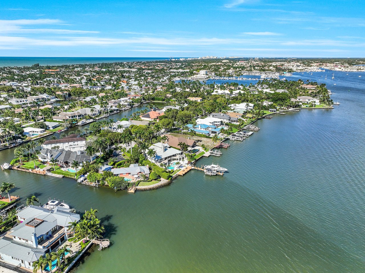
Thinking about buying or selling in Southwest Florida? Tell us what you are trying to do and we will tell you honestly what it will take. McGreevy and Comisar, Domain Realty Group.