Updated September 2026 · Jesse McGreevy and Marc Comisar, Domain Realty
McGreevy and Comisar are the team Royal Harbor sellers call first, and the team buyers call when they want a canal lot read to them from the record. Jesse McGreevy and Marc Comisar lead Domain Realty Group, the #1 Team in Southwest Florida since 2012, and are Top 1% Real Estate Agents Nationally Since 2008, with over $900 million in personal sales between them.
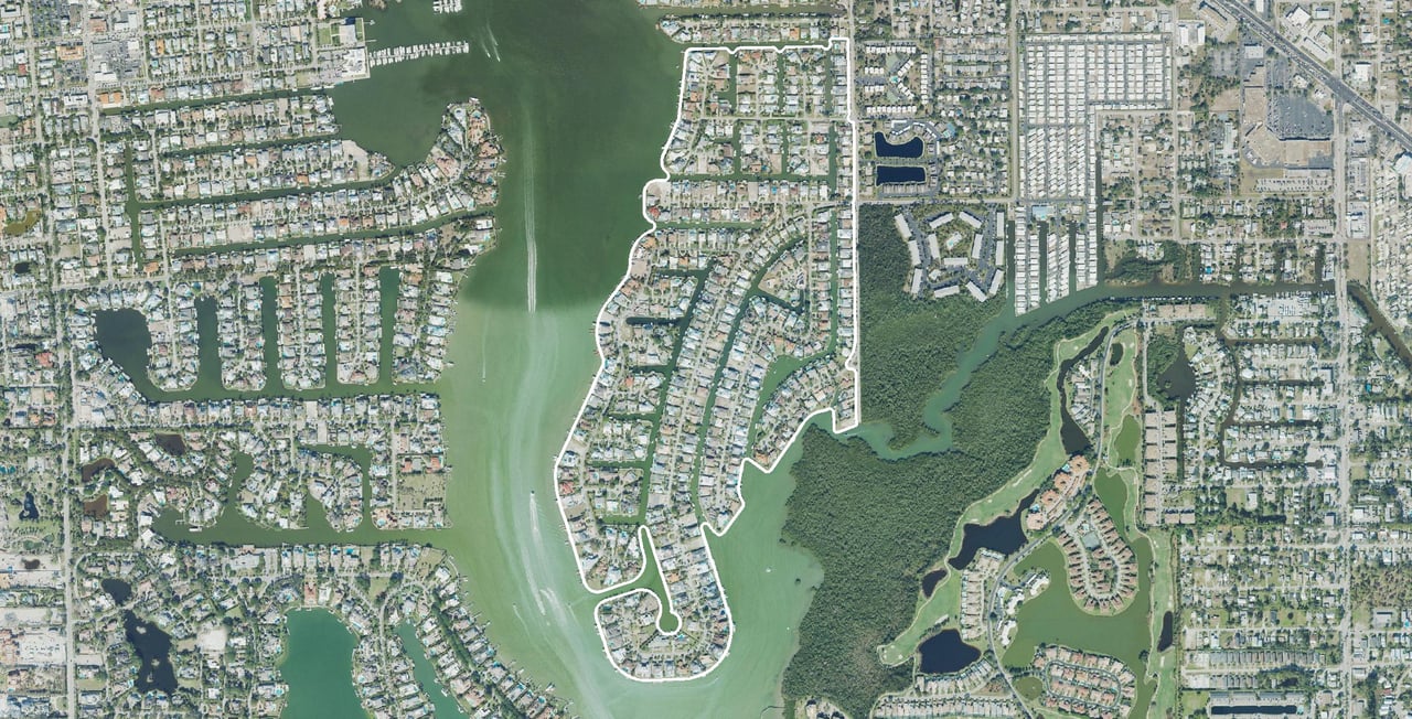
Royal Harbor is a 1950s canal-front neighborhood in Naples, Florida, on the east side of Naples Bay inside the City of Naples, ZIP 34102. Its three recorded plats hold 386 homes and 25 vacant homesites on the Collier County Property Appraiser 2026 preliminary roll, data files dated August 29, 2026, and by our reading of Collier County’s parcel map every one of the 416 platted lots touches water. There is no gate, no mandatory homeowners association and no club: the Royal Harbor Association is voluntary at $50 a year, and 358 of the 421 parcels pay a 0.5-mill City of Naples taxing district that dredges the canals. Collier County recorded 16 qualified Royal Harbor sales in the 12 months to August 29, 2026, with an improved single-family median of $3,700,000. This guide sets out what the plats, the City’s code, FEMA’s maps and the county record prove, and where the record goes silent.
We built this guide the way we price a listing here: from the three recorded plats and the City of Naples’ own ordinances and code, FEMA’s flood maps, NOAA’s Coast Pilot, Collier County’s 2026 tax roll and every qualified sale the county recorded in the neighborhood. Where a figure comes from the Southwest Florida MLS instead, we say so, and where no public record answers a question, we say that too, at the point where it matters, rather than filling the gap with a guess.
Why McGreevy and Comisar Are the Best Realtor for Royal Harbor
McGreevy and Comisar are the best realtor for Royal Harbor because the case rests on the record: the #1 team in Southwest Florida since 2012, Top 1% of agents nationally since 2008, over $900 million in personal sales, and a Royal Harbor read built from the plats, the City’s dock and flood rules and the county’s recorded sales.
If you’re searching for the best realtor for Royal Harbor, whether you’re ready to sell your Royal Harbor home or buy your next one, McGreevy and Comisar is the team that delivers. We lead Domain Realty Group, the #1 real estate team in Southwest Florida since 2012, Top 1% Nationally since 2008, with over $2.5 billion sold as a team and $900 million in personal sales between Jesse and Marc. Jesse and Marc are Top 1% Real Estate Agents Nationally Since 2008, and as the leaders of Domain Realty Group our team has closed over $2.5 billion in real estate.
Recent Royal Harbor track record (last 12 months):
21 homes sold in Royal Harbor · $85.5M in Royal Harbor dollar volume · 86 days median time on market · 90.1% median sale-to-list ratio · highest-priced sold: $15.15M · fastest sold: 5 days
Southwest Florida MLS (Matrix), single-family closings inside the three Royal Harbor plats, September 25, 2025 to September 24, 2026, pulled September 24, 2026 (n = 21).
In Royal Harbor the price of a house is argued lot by lot, not street by street. Every platted lot touches water, but the length of that water edge runs from a cul-de-sac bulb to a point lot, the City’s dock code sets a different envelope on the bay and creek frontage than on the interior canals, FEMA’s 2024 map puts some lots at a 9-foot base flood elevation and others at 8 feet, and 63 parcels sit outside the City’s canal-dredging district while 358 pay it. A house built in the 1960s and a house finished last year can sit side by side on the same canal with county values millions of dollars apart. We price every one of those facts before a listing goes live, and we walk buyers through the same list before they write an offer.
For luxury Royal Harbor sellers: Premium marketing, cinematic video, drone, professional photography, qualified-buyer database, discretion + off-market capability when needed.
Honors and recognition:
- Top 1% Real Estate Agents Nationally Since 2008
- 5 Star Award for Customer Satisfaction for 21 Straight Years. Only 5 out of 21k+ Licensees (Gulfshore Life Magazine)
- #1 Team in Southwest Florida since 2012
- McGreevy and Comisar and their Domain Realty Group team have sold over $2.5 Billion in Real Estate
- McGreevy and Comisar alone have over $900 million in Sales
- Nationally Recognized Top Producing Realtors
- Platinum Sales Production Award Winners
Jesse McGreevy is a top-reviewed Royal Harbor realtor, and the quotes below are five-star client reviews reproduced in each reviewer’s own words. Read the full set on the McGreevy and Comisar Google Business Profile.
★★★★★ “If you’re looking for a Realtor in Naples (or nearby areas), Jesse is your guy. I referred a friend to him for a winter home search. He has great connections, sharp negotiating, and he found them an off-market brand new build. Highly recommend!” Verified Google review
★★★★★ “We highly recommend Marc Comisar for your real estate needs. He was very knowledgeable. If he didn’t know an answer, he would do research until he did. Marc is pleasant, timely, and listened to our wants and needs. He went above and beyond to make sure we found our forever home. Thank you, Marc!” Verified Google review
Selling your Royal Harbor home? Get a free Royal Harbor home valuation OR call Jesse direct at (239) 898-6072 (confidential conversations welcome for luxury listings). Planning a sale? Read how we sell a Royal Harbor home, step by step.
Buying a home in Royal Harbor? Call Marc at (239) 287-5873 for a personalized buyer consultation, or read how we represent Royal Harbor buyers.
Key Takeaways
Royal Harbor is a 1950s canal neighborhood on the east side of Naples Bay where the public record answers most buyer and seller questions directly. These eight facts matter most: what the plats hold, how much water each lot touches, what the association is and is not, what you may build, and what FEMA’s map says.
- 421 parcels, 386 homes. Royal Harbor’s three recorded plats and one small condominium hold 421 parcels: 386 homes, 25 vacant homesites and The Row at Royal Harbor’s five units, all inside the City of Naples, ZIP 34102, on the Collier County Property Appraiser 2026 preliminary roll.
- Every platted lot touches water. By our reading of Collier County’s parcel map, every one of the 416 platted lots touches water, with a median of about 94 feet of water edge per lot.
- A 1957 bulkhead line. The City fixed Royal Harbor’s plat line as the legal bulkhead line on Naples Bay in 1957 under Resolution 633, and the oldest house still standing dates from that year.
- No mandatory HOA, no club. The Royal Harbor Association is a voluntary nonprofit at $50 a year, and no club, clubhouse or gate comes with a Royal Harbor lot.
- A 0.5-mill dredging district. 358 of the 421 parcels pay the City’s 0.5-mill East Naples Bay Special Taxing District, which dredged every Royal Harbor canal reach by December 2025, per the City’s canal map.
- Zoning with its own boat rules. Single-family lots are zoned R1-10 (R1-15 at the south end of Tarpon Road) under a boat and RV storage overlay, and the City’s dock code has its own Royal Harbor paragraph with no limit on boat beam.
- All Zone AE, all evacuation Zone A. Every parcel is in FEMA Zone AE on the 2024 flood map: 342 of 418 at a 9-foot base flood elevation and 76 at 8 feet, and the whole neighborhood is in Collier County’s hurricane evacuation Zone A.
- 16 sales, a $3,700,000 median, one school zone. Collier County recorded 16 qualified sales in the 12 months to August 29, 2026, with an improved single-family median of $3,700,000, and every address is zoned for Lake Park Elementary, Gulfview Middle and Naples High in the district’s school-zone lookup.
Table of Contents
Jump to any part of this Royal Harbor guide. It runs from daily life and the market, through the 1957 origins, the three plats and what the City lets you build, governance and the full fee stack, the water and the beach, storms, flood zones and insurance, schools, healthcare and drive times, what is changing nearby, the comparisons buyers ask for, and both FAQ sets.
Start here
Living here
Rules and costs
Clubs, golf, water and beach
Risk and insurance
Daily life
Deciding
Selling and buying with us
Records
What Is It Like to Live in Royal Harbor as a Homebuyer?
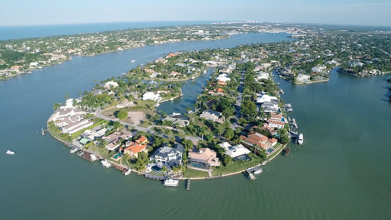
Living in Royal Harbor means a house on a quiet City of Naples street where every platted lot backs onto a canal, the bay or Haldeman Creek, Fifth Avenue South and Tin City are a short bike ride north, and there is no gate, no club and no mandatory homeowners association to answer to.
That combination is less common in Naples than it sounds. Many waterfront neighborhoods on this coast sit behind a gate, come with a club you are expected to join, or put the water at the end of a common dock rather than behind your own seawall. Royal Harbor is none of those. It is three recorded plats of single-family lots cut out of the bay’s eastern mangrove shore in the 1950s, laid out so that every lot would reach the water, and it has stayed a neighborhood of houses under the City’s own zoning rather than a planned community with its own rulebook. What follows is what that means day to day, measured from the public record rather than from brochure copy.
Where Royal Harbor sits in Naples
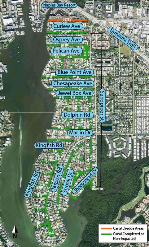
Royal Harbor sits on the east side of Naples Bay, south of US-41 (Tamiami Trail East). Naples Bay forms its west side and the mouth of Haldeman Creek its south end, with Windstar across the creek; Sandpiper Street, the neighborhood’s entrance road from US-41, runs along the east side, and the land east of Sandpiper Street is unincorporated Collier County. Oyster Bay and Golden Shores lie to the north. Those edges come from the record: the City’s 1957 Resolution 633 runs its bay bulkhead line along the Golden Shores, Oyster Bay and Royal Harbor plat lines in that order; the City’s 1998 history booklet, Tales of Naples, places the mouth of Haldeman Creek “between Windstar and Royal Harbor”; the City’s Royal Harbor streets page notes that the east side of Sandpiper Street abuts County land; and the City’s December 12, 2025 canal map shows Sandpiper Street reaching US-41 at the north end.
The federal record uses the same name for the same ground. NOAA’s U.S. Coast Pilot 5 (2026 edition) describes canals dredged and marshland backfilled “to form waterfront homesites in the areas of Port Royal at the south end of the city, Royal Harbor on the east side of Naples Bay, and The Moorings at the north end of the city.” Every Royal Harbor parcel is inside the City of Naples and carries ZIP 34102 on the Collier County Property Appraiser 2026 preliminary roll, data files dated August 29, 2026, which means City police, City fire-rescue, City zoning and City utilities, and the City’s millage on the tax bill.
Directly across Naples Bay, Aqualane Shores is the west-shore canal neighborhood that the City’s 2006 Naples Bay study pairs with Royal Harbor as the two developments that replaced the bay’s mangrove shoreline. The 2006 Naples Bay report puts it plainly: “The mangrove shoreline and the aforementioned habitats were eradicated with the construction of the Aqualane Shores and Royal Harbor developments.” Port Royal, the other name buyers mix up with Royal Harbor, is a separate neighborhood at the south end of the west shore, with its own plats and its own club, and a later section of this guide sets the two side by side.
Every platted lot touches water
By our reading of Collier County’s parcel map, every one of the 416 platted lots in Royal Harbor touches water, with a median of about 94 feet of water edge per lot. Most face a canal; the county map does not separate bay frontage from canal frontage, so the number of true Naples Bay or Haldeman Creek lots is not established. The method: county parcel geometry, each lot boundary buffered 5 feet and tested against the county’s water polygons; The Row’s condominium units are not included. The range runs from 20 feet on a cul-de-sac bulb lot to 333 feet on a point lot.
The water edge is not spread evenly, and the short courts are where it runs longest. Measured the same way on the county’s parcel layer, the median lot on Trout Court has about 186 feet of water edge, Tuna Court 180 feet, Bluefin Court 158 feet, Cobia Court 153 feet, Dolphin Lane 134 feet and Dolphin Court 130 feet. The long streets, Tarpon Road, Snook Drive, Sandpiper Street, Marlin Drive, Bonita Lane, Mullet Lane and Dolphin Road, run 90 to 92 feet at the median. More water edge usually means more dock length and more view, and it is one of the first things we check on any Royal Harbor lot.
A boating neighborhood first
The association describes Royal Harbor as “one of the top boating communities in Naples,” as the association’s website stated in September 2026, and the City’s own code treats it as a special case. The dock section of the City code has a paragraph written for Royal Harbor alone, rewritten by Ordinance 10-12741 in 2010: on the interior canals, “There shall be no restriction on vessel width or beam” (City Code Sec. 56-93). City Council took up dock standards again in 2026; confirm the current text of Sec. 56-93 before designing a dock.
The run to the Gulf matters as much as the dock. NOAA’s Coast Pilot names only one bridge on Naples Bay: the fixed U.S. 41 span at the head of the bay, with 10 feet of clearance, north of Royal Harbor. Royal Harbor’s canals open onto the bay south of it, so the run south to Gordon Pass passes under no bridge the Coast Pilot lists. Canal widths and water depth at each dock, not bridge clearance, are the practical limits. The boating section of this guide covers the route, the speed zones, the dredging and the marinas in detail.
Fifth Avenue South, Tin City and the Naples Bay Resort by bike
Royal Harbor is close to the Naples waterfront on the map and closer still by bicycle. We measured walking and cycling routes over OpenStreetMap streets from the middle of Marlin Drive (retrieved September 23, 2026):
Naples Bay Resort | 1.16 miles | 25 minutes | 8 minutes |
Port-O-Call Marina and the Naples Princess | 1.40 miles | 30 minutes | not measured |
Kelly’s Fish House | 1.44 miles | 31 minutes | not measured |
Tin City | 1.61 miles | 34 minutes | 12 minutes |
Fifth Avenue South at 8th Street South | 1.86 miles | 40 minutes | 14 minutes |
Cambier Park | 2.00 miles | not measured | 16 minutes |
Baker Park | 2.12 miles | not measured | 16 minutes |
Crayton Cove and the City Dock | 2.42 miles | not measured | not measured |
Nearest Gulf beach end | about 3.0 miles | not measured | 21 minutes |
Walk and bike times are free-flow estimates measured from the middle of Marlin Drive; routes follow public streets and bridges, not the water. That is why Crayton Cove and the City Dock, only about 0.67 mile away across the bay, are 2.42 miles away on foot, and why a boat is often the quicker way to lunch on the far shore.
The only road in and out of Royal Harbor is Sandpiper Street to US-41, so trips east to the Botanical Garden or Sugden Park loop around by car even though they look close across Haldeman Creek. The beach is a bike ride or a short drive rather than a walk: the nearest Gulf beach ends are about 3 miles away, and the beach section of this guide covers the City’s free resident parking permit and where to use it.
No gate, no mandatory HOA, no club
Royal Harbor has no mandatory homeowners association. The Royal Harbor Association, Inc. is a volunteer 501(c)(4) nonprofit, and its website invites every homeowner to join for $50 a year, as of September 2026. It speaks for the neighborhood at City Hall and organizes owners around shared projects, but it does not levy assessments, own the canals or approve house plans. The canals are dredged by a City taxing district that owners pay through the property tax bill, and what you may build is decided by the City’s zoning and building codes; both are covered in detail later in this guide.
There is no gate. The streets are public City streets, open to anyone who drives, walks or cycles them, and the entrance is simply Sandpiper Street turning south off US-41. There is no neighborhood club either: no clubhouse, pool, tennis court or marina belongs to Royal Harbor owners as a group, and no club membership comes with a deed. For a buyer that means no initiation fee and no mandatory dues, and it means the private clubs nearby are a separate decision, made club by club.
Year-round and seasonal owners
About six in ten Royal Harbor homes are homesteaded: 233 of the 386 houses carry Florida’s homestead exemption on the Collier County Property Appraiser 2026 preliminary roll, which is the county’s proxy for a primary residence. The rest are not claimed as a Florida primary residence on the roll. The practical effect is the familiar Naples rhythm, fuller streets and busier canals in season and quieter ones in summer, and a steady turnover of houses being rebuilt, which the section on what you can build measures year by year.
One sound Royal Harbor owners do hear is aircraft. On the airport authority’s official Noise Exposure Map for 2026, Royal Harbor lies outside the 60 DNL noise contour the City and County use for land-use planning, by our reading of the map. Aircraft using the airport’s southwest runway end do cross Naples Bay, and a 2023 letter from six neighborhood associations to City Council listed Royal Harbor among the neighborhoods overflown. The airport’s noise program page tracks the authority’s noise work.
The Row at Royal Harbor, the only condominium
The only condominium inside Royal Harbor’s plats is The Row at Royal Harbor, five units on Chesapeake Avenue built in 2018, per the Collier County Property Appraiser 2026 preliminary roll. The Row sits in Zone AE with a 9-foot base flood elevation on FEMA’s 2024 map, like most of the neighborhood, and on the City’s zoning map it is in the R3-12 multifamily district rather than the single-family R1-10 that covers the rest of Royal Harbor.
A buyer searching for “condos in Royal Harbor” should know that answer up front: the plats are single-family lots, and The Row is the one exception. Condominiums that turn up under a “Royal Harbor” label in listing searches are mostly north of the recorded plats, for a reason the market section explains. Because The Row has its own condominium association and its own documents, a purchase there works differently from a house purchase on the canals, and the governance section covers what that means.
What Royal Harbor does not have
A buyer comparing Royal Harbor with a master-planned community should know what is missing as clearly as what is here. Royal Harbor has:
- No club and no clubhouse, and no membership that comes with a lot.
- No golf course.
- No neighborhood marina; boats sit at private docks behind the houses.
- No neighborhood pool, tennis or pickleball courts.
- No community development district and no mandatory association assessment.
- No gate.
- No mandatory association, and no architectural review board for single-family houses; the City’s zoning code decides what is built.
- No public beach inside the neighborhood; the Gulf beach ends are about 3 miles west.
Everything else a household uses day to day, from tennis and parks to groceries, restaurants and the hospital, is a short drive or bike ride away, and each is covered in its own section of this guide with the distance measured.
Choosing an agent for a Royal Harbor purchase
If you are choosing an agent for a Royal Harbor purchase, our comparison of the best real estate agents in Naples sets out production, reviews and licence dates on the public record. In Royal Harbor, the questions that decide a purchase are specific to the lot: how much water edge it has, whether it pays the dredging district, what the City’s dock paragraph allows on that frontage, and what the flood map requires of a new first floor. When you are ready to look at specific lots, call Marc at (239) 287-5873, or read how we represent Royal Harbor buyers.
What Is the Royal Harbor Real Estate Market Doing Right Now?
Collier County recorded 16 qualified Royal Harbor sales in the 12 months to August 29, 2026: 13 improved single-family homes at a median of $3,700,000, two vacant homesites and one parcel the county classes as miscellaneous residential. Prices ran from $2,350,000 for a 1989 house to a record $15,150,000 for a new build in January 2026.
Data updated: September 2026 (Collier County 2026 preliminary roll and qualified sales, files dated 29 Aug 2026; Southwest Florida MLS as shown in the MLS panel)
In the last 12 months we tracked 16 qualified Royal Harbor sales on Collier County’s record, from a $2,350,000 house built in 1989 to a $15,150,000 new build. This section leads with the county’s record because it is public, complete for recorded deeds and tied to the three plats: every figure below comes from the Collier County Property Appraiser 2026 preliminary roll and its qualified-sales table, data files dated August 29, 2026, unless it is labeled as Southwest Florida MLS. A “qualified” sale is a deed the county has reviewed and accepted as an arm’s-length market transfer; the 35 unqualified transfers recorded in the same window, deeds the county did not accept as market sales, are left out. Every median below is the middle sale of its group, with the count (n) beside it; where the count is even, it is the midpoint of the two middle sales.
The last 12 months on the county record
The 16 qualified sales recorded between August 30, 2025 and August 29, 2026, listed by recording month, with no addresses:
October 2025 | $2,450,000 | House built in 1969 |
January 2026 | $15,150,000 | New house built in 2025, 0.42 acre (the neighborhood’s record sale) |
February 2026 | $2,600,000 | House built in 1991 |
February 2026 | $6,600,000 | House built in 2020 |
February 2026 | $5,100,000 | House built in 2004 |
March 2026 | $3,887,500 | House built in 2007 |
March 2026 | $2,975,000 | House built in 1977 |
March 2026 | $3,150,000 | House built in 1996 |
March 2026 | $3,025,000 | House built in 2006 |
April 2026 | $5,300,000 | House built in 2015 |
April 2026 | $6,500,000 | House built in 2017 |
May 2026 | $2,700,000 | A lot carrying only a dock, seawall or pool |
June 2026 | $2,800,000 | Vacant homesite, 0.25 acre |
June 2026 | $2,350,000 | House built in 1989 |
June 2026 | $3,900,000 | Vacant homesite, 0.40 acre |
June 2026 | $3,700,000 | House built in 2013 |
Qualified sales, all kinds | 16 |
Improved single-family sales | 13 (odd) |
Median improved single-family sale price | $3,700,000 (n = 13) |
Improved single-family price range | $2,350,000 to $15,150,000 |
Median price per square foot of the county’s base area of the main building | $1,284.70 (n = 13) |
Vacant homesite sales | 2 (listed above; too few for a median) |
Dock, seawall or pool-only lot sales | 1 |
Unqualified transfers excluded | 35 |
Three cautions go with that table. First, these are recording months, not contract months: the date shown is when the deed was recorded, which follows the contract. Fifteen of the 16 recorded between January 29 and June 19, 2026, the winter and spring months. Second, the price per square foot is measured on the county’s base area of the main building, which is not the same measurement as the living area a listing reports; it belongs only beside other county figures. Third, 13 sales is a small sample. One new build at $15,150,000 does not move the median, but it does show how far apart a 1960s ranch house and a finished new home on a larger lot now trade inside the same neighborhood: the lowest improved sale and the record were more than $12 million apart.
The last 12 months on the MLS
The Southwest Florida MLS adds sales the county has not yet marked qualified.
Closings | 21 |
Median sold price | $2,975,000 |
Median final list price | $3,495,000 |
Median living area | 2,721 sq ft |
Median sold price per sq ft of living area | $1,149.19 (range $878.26 to $2,330.77) |
Median sale-to-list ratio | 90.13% |
Median days on market | 86 (range 5 to 440) |
Closed at or above list | 1 of 21 |
Total dollar volume | $85,490,999 |
Price range | $1,650,000 to $15,150,000 |
Middle 11 of the 21 sales | $2,503,500 to $5,100,000 |
Southwest Florida MLS (Matrix), Development “Royal Harbor”, filtered to addresses inside the three recorded plats, closed September 25, 2025 to September 24, 2026, pulled September 24, 2026. No closings at The Row at Royal Harbor in the window. The MLS measures living area, the county measures base area, so the two per-square-foot figures are never compared.
The MLS and the county count different things. The MLS window runs to September 24, 2026 and counts every closed single-family sale inside the plats; the county’s 16 counts only transfers it qualified as arm’s-length through August 29, 2026, which is why the MLS median ($2,975,000) sits below the county’s improved-home median ($3,700,000): most of the MLS-only closings were older homes under $3,000,000.
The Southwest Florida MLS files some homes and condominiums north of the recorded plats under a ‘Royal Harbor’ development name, so MLS counts for Royal Harbor run higher than the neighborhood itself. This guide counts only sales inside the three plats and The Row, so any MLS figure on this page has been checked against the plats before it is used.
Why the county and the MLS count differently
Collier County counted 16 qualified Royal Harbor sales in the 12 months to August 29, 2026. The MLS counts more single-family closings because its window runs later, it records every closed listing rather than only the deeds the county marks as qualified, and its Royal Harbor label reaches a few streets beyond the plats. The county, for its part, counts vacant homesites and miscellaneous-residential parcels that a single-family MLS search leaves out.
County roll figures and MLS figures measure different things. The county values every parcel as of January 1, and its values are not sale prices; the MLS records only the homes that sold, at their contract price, and measures living area rather than the county’s base area of the main building. The two sets of numbers should never be compared directly.
That is why this guide never sets a county price per square foot beside an MLS price per square foot, and why every median on the page names its record, its window and its count. When you read a single “Royal Harbor median” somewhere else with no record, window or count beside it, you cannot tell which of these measurements you are looking at.
Sales and values year by year
Qualified sales of improved single-family homes, by calendar year of recording, from the Collier County Property Appraiser’s qualified-sales table, data files dated August 29, 2026:
2015 | 36 | 29 | $1,521,000 |
2016 | 19 | 17 | $1,840,000 |
2017 | 35 | 28 | $2,050,000 |
2018 | 25 | 18 | $2,145,000 |
2019 | 28 | 16 | $2,850,000 |
2020 | 63 | 47 | $2,395,000 |
2021 | 48 | 37 | $3,526,200 |
2022 | 20 | 14 | $4,411,000 |
2023 | 13 | 9 | $5,500,000 |
2024 | 16 | 16 | $5,587,500 |
2025 | 18 | 13 | $2,900,000 |
2026, to August 29 | 15 | 12 | $3,793,750 |
With 9 to 16 sales a year, the median swings with the mix of homes that sell, older ranch houses one year and new builds the next; the county’s value for the same 386 homes barely moved from 2023 to 2026. The 2025 median is the clearest example: it fell to $2,900,000 on 13 sales because more of the houses that sold that year were older homes, not because the same houses sold for less. The county’s median just value for all 386 homes, as of January 1 of each year:
2021 | $1,794,274 | certified |
2022 | $2,744,165 | certified |
2023 | $3,788,524 | certified |
2024 | $3,707,844 | certified |
2025 | $3,722,494 | certified |
2026 | $3,673,316 | preliminary |
Read together, the two series tell a consistent story. The county’s median value roughly doubled between 2021 and 2023, from $1,794,274 to $3,788,524, and has held within about 3 percent of the 2023 level since. The busiest sales years in the record were 2020 and 2021, with 63 and 48 qualified sales. Over the last five years the county recorded 93 qualified sales on 82 distinct parcels since August 30, 2021, so by our arithmetic roughly one Royal Harbor parcel in five changed hands in a qualified sale in that time.
What a vacant homesite sells for
Two vacant homesites sold in the last 12 months on the county record: one in June 2026 at $2,800,000 (0.25 acre) and one in June 2026 at $3,900,000 (0.40 acre). Two sales are too few for a median, so they are listed. Qualified sales the county coded as vacant land, by year:
2015 | 7 | median $1,350,000 |
2016 | 2 | two sales, $990,000 and $2,800,000 (too few for a median) |
2017 | 3 | median $2,550,000 |
2018 | 6 | median $1,055,000 |
2019 | 8 | median $1,087,500 |
2020 | 12 | median $2,550,000 |
2021 | 8 | median $2,162,500 |
2022 | 6 | median $3,497,500 |
2023 | 4 | median $2,600,000 |
2024 | none | none |
2025 | 5 | median $2,325,000 |
2026, to August 29 | 2 | two sales, $2,800,000 and $3,900,000 (too few for a median) |
The 25 vacant homesites on today’s roll carry a median county just value of $1,947,400, ranging from $1,595,750 to $4,900,000 (Collier County 2026 preliminary roll, county just value, not a sale price). As with houses, a lot’s price turns on its size, its water edge and whether it faces a canal, the bay or the creek, which is why the two June 2026 sales, 0.25 and 0.40 acre, were more than a million dollars apart.
What is for sale now
Listings change weekly, and the county records a sale only after the deed is filed, so current supply comes from the Southwest Florida MLS rather than from the roll.
On September 26, 2026 the Southwest Florida MLS showed 20 single-family homes for sale inside the three Royal Harbor plats and 2 under contract. The 20 active listings asked from $2,199,000 to $13,995,000, with a median list price of $5,697,500 (n = 20, the mean of $5,400,000 and $5,995,000), a median asking price of $1,786.99 per sq ft of living area and a median 145.5 days on market. Against 21 in-plat closings in the prior 12 months, that is about 11.4 months of supply, a buyer’s-market level of inventory.
Southwest Florida MLS (Matrix), Development “Royal Harbor” filtered to the three recorded plats, active and pending listings, pulled September 26, 2026.
When you read any Royal Harbor listing, check four things against the record before the price: the lot’s base flood elevation on FEMA’s map, whether the parcel pays the East Naples Bay district, the water edge and frontage type, and the age of the house against the City’s 50 percent rule if you plan to renovate rather than rebuild. Each of those is covered in its own section of this guide.
What the county roll says, and why it is not a sale price
The county roll is the only record that describes every Royal Harbor lot, not just the ones that sold. On the Collier County Property Appraiser 2026 preliminary roll, data files dated August 29, 2026 (Collier County 2026 preliminary roll, county just value, not a sale price), the 386 single-family homes carry a median total just value of $3,673,316, made up of a median land value of $1,892,899 and a median improvement value of $1,251,398. At the median, land is 62.4 percent of a Royal Harbor home’s county value.
The same roll splits cleanly by the age of the house:
Before 1980 | 131 | $2,055,236 | $208,982 | 9 percent |
1980 to 2014 | 138 | $3,611,388 | not stated | 39 percent |
2015 or later | 117 | $5,059,831 | $3,112,756 | 57 percent |
And by plat:
Royal Harbor Unit 1 | 168 | $2,883,026 | 0.25 acre |
Royal Harbor Unit 2 | 147 | $3,565,075 | 0.25 acre |
Royal Harbor Unit 3 | 71 | $7,054,877 | 0.41 acre |
The first table is the one to remember. On the county’s own books, an older Royal Harbor house adds a median of about $209,000 to a lot worth far more, while a house built since 2015 is most of its parcel’s value. That is the economics behind the rebuilding described in the next two sections. The second table shows why Unit 3 sits at the top of the neighborhood’s values: its lots are larger and its houses are newer. These are 2026 preliminary roll figures; the November 2026 tax bill is the final record, and the county’s January 1 values are an assessment for taxes, not a forecast of what any house will sell for.
How Did Royal Harbor Come to Be?
Royal Harbor was built in the 1950s by dredging canals through the mangrove and oyster-bar shoreline on the east side of Naples Bay and filling the spoil into waterfront lots. Its first plat was on record by October 1957, when the City of Naples made the recorded plat line the legal bulkhead line on the bay.
Much of the early story survives only in scattered public records: a 1957 City resolution, a 1966 street-renaming ordinance, a 2006 study of Naples Bay, the county’s plat index and a few lines in the City’s centennial history. No developer’s brochure or company archive was found. What follows is built from those records, and where they go silent, this guide says so rather than filling the gap.
Before Royal Harbor: mangroves, oyster bars and seagrass
Before the canals, the east shore of Naples Bay was a living edge of mangroves, oyster reefs and grass flats. The 2006 Naples Bay report, posted by the South Florida Water Management District, describes the central bay “between the eastern entrance of Gordon Pass and the mouth of Haldeman Creek” as shallow and containing “numerous oyster bars and seagrass beds.” Oyster bars, the report says, were “particularly abundant on the east side of the bay, where the Windstar development is today, and also at the mouth of Haldeman Creek,” and “There was a large seagrass bed at the entrance to Haldeman Creek on the east side of the bay.”
That is the ground Royal Harbor was built on. The same report is blunt about what replaced it: “The mangrove shoreline and the aforementioned habitats were eradicated with the construction of the Aqualane Shores and Royal Harbor developments.” It is a useful fact for a buyer as well as a historian, because the lots here are made land, fill placed behind seawalls, and the seawall at the back of every Royal Harbor lot is the structure that holds that fill in place.
1957: the plat line becomes the bulkhead line
Royal Harbor’s first plat was on record by October 9, 1957, when the City of Naples adopted Resolution 633 and fixed the neighborhood’s recorded plat line as the legal seawall and bulkhead line on Naples Bay. Notice of the resolution was published in August 1957, the City held a hearing on September 11, 1957, and Council passed it on October 9, 1957. It runs the line along the Golden Shores and Oyster Bay plats and then “along said recorded plat line of Royal Harbor to its Southerly extremity,” describing Royal Harbor as “a subdivision duly recorded and platted in the records of Collier County,” and it closes with the rule that shaped the shoreline for good: “no filling operations will be permitted outside of the above described seawall or bulkhead line.”
The City’s centennial history lists Royal Harbor among its 1950s developments, in four words: “Royal Harbor was developed.” The oldest house still standing, on Sandpiper Street, dates from 1957 on the county roll. Units 2 and 3 were recorded later in the same plat book. Royal Harbor Unit 1 was on record by October 9, 1957; the recording dates of all three plats are on the plat sheets in Collier County Plat Book 3.
Who dug the canals
The company that platted Royal Harbor is not named in any record we reached; the plat sheets’ dedication blocks will name it. A Naples Daily News history series, reprinted in a local history compilation, reports that Marathon Dredging Co. came to Naples in 1959 to build the land that became Royal Harbor, the Moorings and Park Shore.
The two dates are not in conflict. The 1957 resolution proves at least the first plat was recorded and its bay edge fixed by then; a dredging company arriving in 1959 fits the later units and the remaining fill. What the records do not yet show is the order in which each canal was cut and each block filled.
Three plats in one plat book
Royal Harbor is three recorded plats: Royal Harbor Unit 1 at Collier County Plat Book 3, Page 56; Unit 2 at Plat Book 3, Page 69; and Unit 3 at Plat Book 3, Page 70. The citations appear in the county’s subdivision layer and in City records that describe individual Royal Harbor lots, including City resolutions from 2006 and 2014 (the 2014 resolution accepts a utility easement on a Unit 2 lot), a second 2014 City agenda record and an earlier City record citing the plat.
The neighbors in that plat book place Royal Harbor in its era. Per the county’s subdivision layer, the same Plat Book 3 holds Aqualane Shores Unit 6 (page 20, recorded 1954), Oyster Bay Unit 3 (page 63), Port Royal’s Gin Lane and Rum Row plats (pages 74 and 75) and Moorings Unit 1 (page 81). Royal Harbor’s three units sit among the canal subdivisions that remade the Naples shoreline in the 1950s. Block numbers also continue from one unit to the next (“Block 12” appears in both Unit 2 and Unit 3), which suggests one master layout recorded in stages. The three units are one neighborhood on the ground today: the same voluntary association, the same City zoning and the same dredging district cross the unit lines.
Inside the City of Naples
Royal Harbor has been City of Naples ground from its first records. Resolution 633 set its bulkhead line in 1957 “within certain portions of the City Limits,” and in 1966 Ordinance 1205 renamed streets “WITHIN THE CITY LIMITS OF THE CITY OF NAPLES” that include the “ROYAL HARBOR SUB-DIVISION.” No annexation ordinance naming Royal Harbor turned up in the City records reviewed for this guide.
For an owner that has practical consequences today. Royal Harbor pays City millage and gets City police, City fire-rescue, City water and sewer, City trash collection and City zoning, and its streets are City streets. The land east of Sandpiper Street, by contrast, is unincorporated Collier County, which is why the projects along Bayshore Drive and US-41 East are County projects, governed by County rules.
How the bay changed, 1927 to 1965
The 2006 Naples Bay report measured what the canal neighborhoods did to the bay’s outline. In 1927 the bay had 45.5 kilometers of shoreline and 820.3 acres of water. “By 1965, the shoreline perimeter had increased by 49.8% and the surface area increased by 22.9% … due to the construction of the canal systems that formed the Aqualane Shores, Port Royal and Royal Harbor residential communities,” the report states. After that the pace slowed: “Between 1965 and 1978 … Shoreline changes were primarily limited to construction of canals north of Royal Harbor.”
The report’s overall verdict is that “over 70% of the fringing mangrove shoreline has been converted to residential developments,” and it adds a line every buyer of a canal lot should know: “Permits were not required in early days, so the records of dredging are incomplete or nonexistent.” NOAA’s Coast Pilot still records the result in its description of Naples Bay: canals were dredged and former marshland backfilled to form waterfront homesites, naming Royal Harbor on the east side of the bay alongside Port Royal and The Moorings.
Fish and bird streets, and the 1966 renaming
Royal Harbor’s streets are named for fish and birds, as the association’s website points out, and a walk down the street list proves it: Tarpon, Snook, Kingfish, Marlin, Sheepshead, Dolphin, Bonita, Mullet, Bluefin, Cobia, Wahoo, Tuna, Trout and Shad for the fish, and Sandpiper for the birds. Who chose the names is not recorded.
On May 18, 1966, the City renamed three of them. Ordinance 1205 changed Bonita Lane to Bonita Court, Mullet Lane to Mullet Court and Dolphin Lane to Dolphin Court, because “Much confusion had developed within the City of Naples due to duplication of street names.” That is why Royal Harbor still has both a Bonita Lane and a Bonita Court, a Mullet Lane and a Mullet Court, and a Dolphin Lane and a Dolphin Court.
The water at the south end has a namesake of its own. Haldeman Creek, the City’s Tales of Naples records, is named for Walter N. Haldeman, the owner and publisher of the Louisville Courier-Journal, who used his paper in the 1880s to launch the ad campaign behind many of the first land purchases in Naples.
Sewer in the 1970s, new water mains in 2016
City utilities arrived in stages. The City’s centennial history records that in the 1970s “Construction of a sewer system in Royal Harbor was initiated.” Four decades later the City rebuilt the water system: its agreement for the project describes replacing asbestos-cement water mains in the Royal Harbor area, the City accepted utility easements for the “Royal Harbor Water System Improvement Project” in 2014 under Resolution 14-13557, and the City’s Comprehensive Plan records that in 2016 “the City completed a $5-million upgrade of the water distribution system located in the Royal Harbor area.”
The association on the City record since 1994
The association has spoken for the neighborhood before City Council since at least 1994, according to Council minutes. At a January 10, 1994 workshop, the minutes record that the association asked City Council to act against a Royal Harbor house being sold in time-share intervals; the City Attorney advised that the City controls zoning and land use, not ownership. That episode is history, not a current rule, and the City’s current short-term rental rules are covered in the logistics section.
The next year the association was at the table for the City’s dock rules. The 1995 Council minutes record that the association had asked for Royal Harbor to be excluded from the new dock regulations, and that the draft then before Council “simply states that a pier in Royal Harbor may not encroach any farther than the platted dock limit line, which is 5 feet.” The City’s dock code still carries a paragraph written for Royal Harbor today, described in the next section.
The aerial record
The before-and-after photographs of Royal Harbor exist in public collections, though no single frame has been matched to the neighborhood for this guide. The University of Florida’s aerial photography collection lists USDA flights over Collier County in 1952, 1953, 1962, 1963, 1969 and 1980, with a 1953 flight index online, and flights from before and after 1957 bracket the years the plats were recorded. The 2006 Naples Bay report compares the bay in 1931, 1957 and 1968 in its opening figures. Anyone who wants to see the east shore before and after the dredges can start there.
From 1960s ranch houses to today’s rebuilds
The oldest surviving houses on the county roll date from 1957, on Sandpiper Street, and 1958, on Marlin Drive, the landward edge and the first plat. After that Royal Harbor filled steadily, then began to rebuild itself. By the decade the main building was built, on the Collier County Property Appraiser 2026 preliminary roll:
1950s | 2 |
1960s | 62 |
1970s | 67 |
1980s | 23 |
1990s | 24 |
2000s | 62 |
2010s | 66 |
2020s | 80 |
The median Royal Harbor house on the roll was built in 2001, and 80 of the 386 were built in the 2020s alone. The 1960s and 1970s houses still standing, 129 of them, are what remains of the original neighborhood. The 2000s, 2010s and 2020s rows are the newer houses, and with only 25 vacant homesites left on the roll, a new Royal Harbor house today usually means an older one coming down first. The next section explains the rules that shape those new houses and the economics that drive the rebuilding.
How Was Royal Harbor Platted, and What Can You Build on a Lot Today?
Royal Harbor was platted as three units in Collier County Plat Book 3, and today the City of Naples R1-10 zoning district, R1-15 at the south end of Tarpon Road, decides what you can build: a 30-foot height limit measured from the flood-driven first floor, a sliding building-area cap and a boat-storage overlay.
No recorded declaration of covenants binding Royal Harbor’s three single-family plats turned up in the records we reviewed, so for a new house the rulebook is public: the City’s zoning code, its flood rules and its dock code. That makes Royal Harbor unusually easy to read in advance. Most of what a buyer needs to know about a lot can be worked out before an architect is hired, and this section works through it in the order we do when we walk a buyer or a seller through a Royal Harbor lot.
The three plats, unit by unit
Royal Harbor’s 416 platted parcels split across three units, plus The Row’s five condominium units, on the Collier County Property Appraiser 2026 preliminary roll, data files dated August 29, 2026 (single-family homes; Collier County 2026 preliminary roll, county just value, not a sale price):
Royal Harbor Unit 1 | Plat Book 3, Page 56 | 185 | 168 | 14 | 1993 to 1994 (even count) | 0.25 acre | $2,883,026 |
Royal Harbor Unit 2 | Plat Book 3, Page 69 | 156 | 147 | 7 | 2002 | 0.25 acre | $3,565,075 |
Royal Harbor Unit 3 | Plat Book 3, Page 70 | 75 | 71 | 4 | 2011 | 0.41 acre | $7,054,877 |
The Row at Royal Harbor (condominium) | condominium, not a plat | 5 | 5 condominium units | none | 2018 | not applicable | not shown |
Unit 1 also holds two parcels that carry only a dock, seawall or pool and one City of Naples parcel, and Unit 2 two more dock, seawall or pool parcels; that is why the homes and vacant columns do not add up to the parcel column. The plat citations appear in City records that describe individual lots, including resolutions in 2006 and 2014 and a second 2014 agenda record. Royal Harbor Unit 1 was on record by October 9, 1957; the recording dates of all three plats are on the plat sheets in Collier County Plat Book 3.
Unit 1 is the oldest plat, with the most pre-1980 houses; Unit 3, which holds Trout Court and parts of Tarpon Road, Snook Drive and Kingfish Road, has the largest lots and the newest houses, and its median county value is more than twice Unit 1’s. Those are differences of price and product inside one neighborhood, not different rules: all three units share the same zoning district, the same voluntary association and the same dredging district.
Royal Harbor’s single-family streets are zoned R1-10 by the City of Naples, with R1-15 at the south end of Tarpon Road, and both carry the City’s Recreational Vehicle Storage Overlay District, per the City’s zoning map. In the City’s zoning map the overlay appears on only three zoning polygons, and every Royal Harbor single-family address we sampled falls inside one of them. The Row at Royal Harbor sits in the R3-12 multifamily district. The City’s zoning map shows R1-15 at the south end of Tarpon Road; confirm any lot’s district on the City zoning map.
The main standards, from the City of Naples zoning code (R1-10 and R1-15 districts), as printed in the City’s R1-10 and R1-15 zoning extracts linked from its zoning map, with the district text in the City Code:
Minimum lot area | 10,000 sq ft | 15,000 sq ft |
Minimum lot width | 75 ft interior, 87.5 ft corner | 100 ft |
Front yard | 30 ft | 40 ft |
Side yard | 7.5 ft, then a 12:12 slope above 15 ft | 10 ft, then a 12:12 slope above 15 ft |
Rear yard | 25 ft | 30 ft |
Maximum height | 30 ft, measured from the base described below | 30 ft, measured the same way |
Minimum floor area | 1,200 sq ft one-story, 1,600 sq ft two-story | not stated in this table |
Parking | one space inside the building area | one space inside the building area |
The height rule is the one that shapes every new Royal Harbor house. The 30 feet is measured from the greatest of four bases: the first habitable floor FEMA requires, 18 inches above the state environmental agency’s structural requirement, 18 inches above the average crown of the adjacent road, or average natural grade. On a low canal lot the flood rule is almost always the highest of the four, so the 30 feet starts at the flood-driven floor, not at the ground. The 12:12 side slope means that above 15 feet the side setback grows one foot for every foot of added height, so upper floors step back from the side lot lines. Confirm the current table in the City code before a design is drawn.
How the flood map sets the height of a new house
The City sets a new house’s lowest floor by adding a foot of freeboard to FEMA’s base flood elevation: its flood mitigation guidance makes the design flood elevation the base flood elevation plus 1 foot. On FEMA’s map effective February 8, 2024, every Royal Harbor parcel is in Zone AE, and measured at the street side of each lot, 342 of 418 parcels carry a base flood elevation of 9 feet NAVD88 and 76 carry 8 feet (FEMA National Flood Hazard Layer). By our arithmetic, a new house’s first floor therefore sits at 10 feet NAVD88 on an AE 9 lot and at 9 feet on an AE 8 lot.
The water side of a canal or bay lot can be mapped higher, and a few bay-front lots on Kingfish Road sit close to a high-velocity VE zone, so the elevation certificate or a survey settles any one house. The difference between an AE 8 and an AE 9 lot is a foot of fill or foundation, a foot of stairs to the front door and a foot off the 30-foot envelope, and it can affect the flood insurance premium. The flood-zone section of this guide names the AE 8 streets and sets out what the map means for insurance.
How big a house fits on a Royal Harbor lot
The City caps the total roofed and enclosed building area on a single-family lot with a sliding scale, as printed in the City’s R1-10 zoning extract linked from its zoning map: 48 percent of the first 5,000 square feet of lot, 35 percent of the next 5,000, 24 percent of the next 10,000, 20 percent of the next 30,000, 15 percent of the next 50,000 and 10 percent thereafter.
A worked example, labeled as our arithmetic on that table: the median Royal Harbor lot is about 11,326 square feet. 48 percent of 5,000 (2,400) plus 35 percent of 5,000 (1,750) plus 24 percent of the remaining 1,326 (about 318) comes to about 4,468 square feet of roofed and enclosed building area, about 39.5 percent of the lot. Confirm the current table in the City code before a design is drawn.
Because the percentages step down as the lot grows, the table rewards lot size without letting a house cover a large lot edge to edge. On one of Unit 3’s larger lots, a median of 0.41 acre on the 2026 preliminary roll, the same table allows a larger house than on the neighborhood’s median 0.26-acre lot, which is one reason lot size carries so much of the price here. Single-family lots on the roll run from 0.21 to 0.72 acre, so the envelope varies widely from one Royal Harbor lot to the next.
The boat and RV storage overlay
Royal Harbor’s overlay is written for a boating neighborhood. Under the City’s Recreational Vehicle Storage Overlay District (Code secs. 58-1161 to 58-1168, Ordinance 99-8681, as set out in the City’s R1-10 and R1-15 district extracts), recreational vehicles include boats, personal watercraft and anything on a trailer. None may be kept in an open carport, a front yard or a side yard, and none in the rear yard of a waterfront lot, except that boats and personal watercraft “may be hung on davits at the bulkhead or landward of the bulkhead.”
In Royal Harbor a trailered boat lives in a garage, on a lift or in the water, not in the driveway or side yard. For a buyer who trailers a boat, that makes garage depth and door height part of the house search, and for a seller with a new house, a boat-ready garage is a feature worth pricing.
The platted property line 5 feet out in the water
Royal Harbor’s plats put each lot’s property line 5 feet out into the water from the seawall line, which is why City staff have treated Royal Harbor as a special case when measuring waterfront setbacks, per a 2013 Planning Advisory Board presentation. The same line governs docks. The City’s dock code, as rewritten by Ordinance 10-12741 in 2010, carries a Royal Harbor paragraph, Sec. 56-93(c)(6), in two parts (City Code Sec. 56-93):
- “(a) All interior canals and waterways. The shore-normal dimension for a pier shall not exceed the platted property line, said line being 5 feet off shore from the platted seawall line. There shall be no restriction on vessel width or beam.”
- “(b) Properties facing Naples Bay and Haldeman Creek. … Final dimensions shall be agreed upon by the property owner, the Royal Harbor Association, and the city manager.”
The one place City code gives the voluntary association a formal role is dock sizing on the Naples Bay and Haldeman Creek frontage. The history goes back to 1995, when Council minutes record a draft stating that a pier in Royal Harbor “may not encroach any farther than the platted dock limit line, which is 5 feet” (1995 minutes). City Council took up dock standards again in 2026; confirm the current text of Sec. 56-93 before designing a dock.
In practice the 5-foot line keeps interior-canal piers close to the seawall, while the beam of the boat tied to them is not limited. On the bay and creek frontage, the dimensions are set case by case.
Teardown economics: the land is most of the value
On the county’s books, most of an older Royal Harbor home’s value is the lot. The 131 homes built before 1980 carry a median county just value of $2,055,236, of which land is a median $1,777,588 and the building a median $208,982, about 9 percent. The 117 homes built in 2015 or later carry a median of $5,059,831, with the building a median $3,112,756, about 57 percent. Across all 386 homes, land is 62.4 percent of value at the neighborhood median (Collier County 2026 preliminary roll, county just value, not a sale price; Collier County Property Appraiser 2026 preliminary roll, data files dated August 29, 2026).
That gap is the rebuild decision in one line. A buyer paying for an older house is mostly paying for the lot, the water edge and the dock rights, and the house is valued by the county at a fraction of the price. Whether to renovate or rebuild then turns on two rules covered in this section: the flood-driven first floor, which an older house may sit below, and the City’s 50 percent rule, which decides when a renovation must bring the whole house up to current flood standards. The streets whose median house dates from 1972 to 1977, Wahoo Court, Sandpiper Street, Mullet Lane, Dolphin Road, Shad Court and Bonita Lane, hold much of that older stock.
How fast Royal Harbor is rebuilding
New homes by the year the main building was built, on the Collier County Property Appraiser 2026 preliminary roll:
2015 | 11 |
2016 | 10 |
2017 | 4 |
2018 | 2 |
2019 | 10 |
2020 | 11 |
2021 | 12 |
2022 | 19 |
2023 | 16 |
2024 | 11 |
2025 | 11 |
That is 117 homes built in 2015 or later, 30 percent of the neighborhood’s 386, and 80 in the 2020s alone. By street, most stand on Tarpon Road (35), Snook Drive (23) and Kingfish Road (15). Rebuilding was already running at 10 to 12 homes a year before Hurricane Ian, and the 2022 and 2023 peak of 35 homes straddles the storm; the county roll does not say which new homes replaced damaged ones. The City has not published storm damage counts by neighborhood. Houses under construction in 2026 do not yet appear on the preliminary roll, which lags construction.
The 25 vacant homesites
The 2026 preliminary roll lists 25 vacant homesites spread across 14 streets, with a median county just value of $1,947,400 and a range of $1,595,750 to $4,900,000 (Collier County 2026 preliminary roll, county just value, not a sale price). By plat, Unit 1 holds 14 of them, Unit 2 seven and Unit 3 four. The roll does not say whether any of them is awaiting a new house.
For a buyer who wants to build, a vacant homesite skips the demolition step and the question of what an older house is worth, but it does not skip anything else in this section: the lot still takes its first-floor height from the flood map, its envelope from the zoning table and its dock from Sec. 56-93. The two vacant homesites that sold in June 2026, described in the market section, show the spread: $2,800,000 for 0.25 acre and $3,900,000 for 0.40 acre.
The 50 percent rule on an older house
In the City of Naples, work on a home in a flood zone counts as a substantial improvement when its cost reaches 50 percent of the structure’s market value before the work. The City used a one-year cumulative lookback from 2007 until December 4, 2024, when Ordinance 2024-15508 eliminated it. The City measures the structure’s value from the county’s assessed building value or an owner’s licensed appraisal of depreciated replacement cost, per its development and floodplain page.
Every Royal Harbor parcel is in Zone AE, so the rule applies to every house. For the older stock it bites early. As an illustration only, at the median pre-1980 improvement value of $208,982, the City’s 50 percent threshold would be reached by about $104,500 of work, if the City used the county’s building value. Crossing the threshold means the whole house must be brought up to current flood standards, including the elevated first floor, which is why a large renovation of a 1960s or 1970s Royal Harbor house can turn into a rebuild. That arithmetic is not a City determination for any house; the City decides each permit on its own valuation.
Splitting or combining lots
The median Royal Harbor lot, about 11,300 square feet, cannot be split into two lots that each meet R1-10’s 10,000-square-foot minimum, by our arithmetic on the City’s R1-10 standards. Combining lots is governed by the City’s lot-combination rules, adopted as Ordinance 2023-15041 on February 1, 2023, per the City’s 2023 voting record; read the current rules before planning a combination.
There is no neighborhood design review. The City’s Design Review Board page states that “Single family zoning districts are not subject to design review” (City Design Review Board), so a new Royal Harbor house is reviewed for zoning, building and flood compliance rather than for style. The Row’s R3-12 site is a multifamily district and follows the City’s multifamily rules instead.
Buying or Selling in Royal Harbor? Talk to the Team That Reads the Plats, the Dock Code and the Flood Map
Royal Harbor’s 416 platted lots all touch water, but the dock envelope, the flood elevation and the district tax change lot by lot. McGreevy and Comisar are Top 1% Real Estate Agents Nationally Since 2008, and we read those records for every Royal Harbor listing and every offer. Selling? Get a free Royal Harbor home valuation, or call Jesse direct at (239) 898-6072. Buying? Call Marc at (239) 287-5873 or read how we represent Royal Harbor buyers.
Who Governs Royal Harbor?
Royal Harbor is governed by the City of Naples, not by a homeowners association. City Council, the City code and City staff set the zoning, dock, seawall, flood and rental rules. The Royal Harbor Association, Inc. is a voluntary nonprofit at $50 a year, and only The Row at Royal Harbor has an association of its own.
That structure surprises buyers who arrive from gated communities elsewhere in Collier County. There is no master association sending a quarterly bill, no architectural review committee approving paint colors and no private covenant book handed over at closing. The rules that decide what can be built on a Royal Harbor lot, how far a dock may reach and where a boat trailer may sit are public law, written by the City of Naples and enforced by City departments. Royal Harbor has no mandatory homeowners association, whatever some listings call it.
The City of Naples sets the rules
Every one of Royal Harbor’s 421 parcels sits inside the City of Naples, ZIP 34102, on the Collier County Property Appraiser 2026 preliminary roll, data files dated August 29, 2026. That makes the City the governing body for the neighborhood in the same way a homeowners association would be in a planned community, only with public meetings, published codes and elected officials.
“Naples has a seven-member City Council consisting of a Mayor and six council members who are nonpartisan and elected at large. Serving four-year terms, City Council members and the Mayor are limited to two consecutive terms per the City Charter,” according to the City Council page. Because every seat is elected at large, there is no district seat for the east side of Naples Bay: every Council member represents Royal Harbor. Regular Council meetings are held on the first and third Wednesdays of the month, per the same page. The City’s most recent general election, on February 3, 2026, filled three Council seats for four-year terms, per the City Clerk’s 2026 general election page.
Royal Harbor, inside the City, is served by the Naples Police Department, not the Collier County Sheriff, and on the water by the Police Department’s Marine Unit. Zoning is set in the City’s own code: Royal Harbor’s single-family streets are zoned R1-10, with R1-15 at the south end of Tarpon Road, and both carry the City’s Recreational Vehicle Storage Overlay District, per the City’s published zoning map layer. Docks follow Sec. 56-93 of the City code, seawalls Sec. 52-92, and flood construction Chapter 16. Short-term rentals, tree removal, construction hours and trash collection are City matters too.
For a buyer this has a practical upside. The rules are searchable, the meetings are public, and nobody can change the building envelope on a lot without a public ordinance. The trade-off is that no private board stands between an owner and a neighbor’s construction project: if a new house next door meets the City code, it gets built.
Royal Harbor Association: voluntary, $50 a year
Royal Harbor has no mandatory homeowners association. The Royal Harbor Association, Inc. is a volunteer 501(c)(4) nonprofit, and its website invites every homeowner to join for $50 a year, as of September 2026. The association describes itself as “a volunteer, 501 C (4) non-profit organization, focused on continued enhancement of our waterfront community and representation of Royal Harbor interests in the broader community,” and its dues line is plain: “For $50 annual dues, all Royal Harbor homeowners are invited to join the Association,” per the association’s own page. The 2026 dues are paid online, with an optional donation, through its payment page.
The name matters. The association signs its letters to City Council as “Royal Harbor Association, Inc.”, as on a 2017 letter to the Mayor and Council. Over the decades City records have also called it a property owners’ or homeowners’ association; it is neither a mandatory HOA nor a condominium association. The association has spoken for the neighborhood before City Council since at least 1994, according to Council minutes from January 1994.
The budget is small and volunteer-run. IRS filings show about $25,600 of revenue and $12,600 of spending in fiscal 2024, per the IRS return data published by ProPublica’s Nonprofit Explorer. The state’s corporate registry was offline for maintenance when this guide was researched; the association’s Sunbiz record will be added when it is read. The association’s bylaws and minutes are shared with members; membership is open to homeowners for $50 a year.
What the association does, and what it does not do
On its own page, as the association’s website stated in September 2026, dues fund “special projects such as the entrance monuments, security cameras, and landscaping.” The same page lists the roles its volunteers take on: representing Royal Harbor with the City of Naples, working with other neighborhood associations, acting as a liaison with the City on code compliance, and running projects on fiber internet, natural gas and burying the power lines. It also covers beautification, holiday decorations, communications and community events. “Several board members are involved in the East Naples Bay Taxing District,” the association says. Each membership also carries a Naples Resident Club Card, a local merchant discount card.
What the association does not do is just as important for a buyer. It does not levy a mandatory assessment. It does not approve house plans, paint colors or landscaping. It does not own a clubhouse, pool, park or dock; Royal Harbor has no yacht club, clubhouse, park or dock that belongs to the neighborhood. A seller does not need an association estoppel letter to close the sale of a single-family house here, because there is no mandatory association to issue one.
The association’s larger projects show both its reach and its limits. On burying the overhead power lines, the Royal Harbor Association reported in November 2025 that a City-commissioned feasibility study came to about $30,000 per lot and that the project is on indefinite hold, per its infrastructure update. The association advocated; the City would have had to adopt any assessment. The cost estimate is as the Royal Harbor Association reported it in November 2025.
The one place City code gives the voluntary association a formal role is dock sizing on the Naples Bay and Haldeman Creek frontage. Sec. 56-93(c)(6)(b), as rewritten by Ordinance 10-12741 in 2010, says that for properties facing Naples Bay and Haldeman Creek, “Final dimensions shall be agreed upon by the property owner, the Royal Harbor Association, and the city manager.” The City’s current dock code also lets the city manager consult “the subdivision property owners’ association, if applicable” when weighing a dock exception under Sec. 56-93(e).
That role has a history. In 1995 the association asked City Council to leave Royal Harbor out of new citywide dock regulations, and the version Council considered “simply states that a pier in Royal Harbor may not encroach any farther than the platted dock limit line, which is 5 feet,” per the May 1995 Council minutes. Membership stays voluntary, but an owner on the bay or creek who wants a larger dock will be dealing with the association whether or not the household pays its $50. The boating section below sets out both paragraphs of the Royal Harbor dock rule in full.
The Row at Royal Harbor’s condominium association
The Row at Royal Harbor is the exception to the no-association rule. The five condominium units on Chesapeake Avenue, built in 2018, sit in the City’s R3-12 multifamily district on the zoning map and are recorded on the 2026 preliminary roll as a condominium. The Row at Royal Harbor has its own condominium association, a Florida not-for-profit corporation filed on December 19, 2018 and listed as active on Sunbiz, the state registry (document N18000013207).
A buyer of a Row unit is buying into a condominium regime, with a declaration, a budget and assessments, which is a different transaction from buying any house around it. The condominium association does not publish its assessments; the estoppel certificate at resale states them. The Row’s condominium documents and building height decide whether Florida’s condominium milestone rules apply; ask for them at resale.
Our full guide to The Row at Royal Harbor covers the condominium association, every recorded sale since 2019 and the county values unit by unit. Owners can start with the Row home valuation or the Row seller guide.
The East Naples Bay district and its advisory committee
The one public body that exists only for Royal Harbor and its neighbors is the East Naples Bay Special Taxing District. City Ordinance 87-5330, adopted August 5, 1987, created it as a dependent special district of the City, governed by City Council. Its boundary language is specific: “The District includes all of the canals of Golden Shores, Oyster Bay, and Royal Harbor Subdivisions … The District does not include properties facing Naples Bay.” Its purpose is canal “maintenance dredging,” and it “may provide seawall inspection and surveillance of surface water pollution problems for necessary cleanup.”
The district’s money comes from an ad valorem levy capped at one-half mill, a cap set by referendum of the district’s voters; the City’s district financial summary confirms the 0.5000 mill rate “is based on the cap that was included in the referendum.” The City’s registration page for the district lists it as active and dependent, with the functions “Environmental Protection/Management, Inland Navigation, and Waterways” and no authority to issue bonds. It also appears on the City’s list of dependent special districts.
Residents have a formal voice through the East Naples Bay Citizens Advisory Committee, whose members are appointed by City Council, per the City’s 2024 and 2025 voting records. The committee meets on the second Monday of every month, per the district page. The fee stack section below shows what the district costs a Royal Harbor tax bill, and the boating section shows what it has paid for.
No community development district, and outside both redevelopment areas
No community development district levy appears on any Royal Harbor parcel on the 2026 preliminary roll, and the roll’s millage lines show only County, school, City, East Naples Bay and water management and mosquito control levies. Royal Harbor’s 2026 preliminary tax lines carry no Collier County Haldeman Creek levy either; its canal dredging is funded through the City’s East Naples Bay district.
Royal Harbor is inside the City of Naples but outside both the City’s community redevelopment area and the County’s Bayshore Gateway Triangle CRA, whose projects sit across Haldeman Creek and along US-41 East. Point tests against the County’s Bayshore CRA boundary layer and the City’s CRA district layer returned no Royal Harbor point in either. That means no redevelopment-area rules apply to Royal Harbor lots, and redevelopment money raised in those areas is spent in those areas.
Recorded restrictions: what the record shows
No recorded declaration of covenants binding Royal Harbor’s three single-family plats turned up in the records we reviewed; the rules that govern what you can build are the City of Naples’ zoning and building codes. A title search on a specific lot shows what, if anything, is recorded against it. The Collier County Clerk’s Official Records search is where a title company runs that search.
The City’s own permit forms reflect the same caution. Its seawall permit checklist tells applicants to “Check/verify deed restrictions based on location of the jobsite, association approval may be required.” For a Royal Harbor buyer, the title commitment issued during the purchase is the document that answers the question for the specific lot, and it is worth reading before the inspection period ends.
Which boards and districts cover Royal Harbor
Because Royal Harbor has no private architectural board, the public boards are the ones that matter:
- City Council adopts the zoning, dock, seawall and flood ordinances, the City millage and the East Naples Bay district’s budget, per the City Council page.
- The city manager decides dock exceptions under Sec. 56-93(e) and signs off on bay-front and creek-front dock dimensions with the owner and the association, per the dock code.
- The Design Review Board reviews commercial and multifamily projects, not single-family houses, per the City’s Design Review Board page, so a new Royal Harbor house goes straight to permitting.
- The East Naples Bay Citizens Advisory Committee advises Council on the district’s dredging and budget, per the district page.
- The Royal Harbor Association speaks for members and has the codified dock role described above, per its own page.
- The Row’s condominium association governs only its five units.
What Will You Actually Pay to Own a Home in Royal Harbor? (The Fee Stack)
Owning a Royal Harbor house means paying Collier County property tax at 9.5076 mills on the 358 parcels inside the East Naples Bay district, or 9.0076 outside it, City of Naples utility charges billed every two months, and optional $50 association dues. There is no mandatory association fee, no community development district and no club dues.
Data updated: September 2026 (Collier County Property Appraiser 2026 preliminary roll, data files dated 29 Aug 2026; City of Naples 2026 utility rates; association website, retrieved 26 Sep 2026)
The Royal Harbor fee stack is short compared with a gated master-planned community, but the property tax line is large, because it is levied on the value of waterfront land inside the City of Naples. The tax figures below come from the Collier County Property Appraiser 2026 preliminary roll, data files dated August 29, 2026: Collier County 2026 preliminary roll, county just value, not a sale price. The utility figures come from the City’s 2026 utility rate sheet, effective October 1, 2025. These are 2026 preliminary roll figures; the November 2026 tax bill is the final record.
The Royal Harbor fee stack at a glance
Collier County | 3.2449 mills | Annual, November tax bill | Countywide services, sheriff, parks, land conservation | 2026 preliminary roll |
Collier County School Board | 4.1470 mills | Annual | Public schools | 2026 preliminary roll |
City of Naples | 1.2900 mills (up from 1.23) | Annual | Police, fire, parks, planning | 2026 preliminary roll; Gulfshore Business (adopted September 16, 2026) |
East Naples Bay Special Taxing District (358 of 421 parcels) | 0.5000 mill | Annual | Canal maintenance dredging, seawall inspection, pollution surveillance | Ordinance 87-5330; district page; FY2026-27 budget $400,015 (agenda item) |
Water management and mosquito control districts | 0.3257 mills combined | Annual | South Florida Water Management District, its Big Cypress Basin, Collier Mosquito Control District | 2026 preliminary roll |
Non-ad-valorem assessments | $0 on every parcel on the 2026 preliminary roll | n/a | n/a | 2026 preliminary roll (final bill November 2026) |
Stormwater utility | $49.56 per single-family home | Every two months (from October 1, 2025) | City drainage system | City of Naples 2026 utility rates |
Solid waste (garbage $39.14, horticulture $12.68, recycling $8.96, county disposal $16.30) | $77.08 | Per billing cycle | Trash, yard waste, recycling | City of Naples 2026 utility rates |
Water | Base $21.48 (5/8 to 3/4 inch meter) plus block rates per 1,000 gallons | Every two months | Potable water | City of Naples 2026 utility rates |
Sewer | Base $53.76 plus $5.21 per 1,000 gallons, capped at 20,000 gallons for a single-family home | Every two months | Wastewater | City of Naples 2026 utility rates |
Royal Harbor Association | $50 | Annual, voluntary | Membership, entrance monuments, cameras, landscaping, City liaison | Association; payment page (September 2026) |
The Row at Royal Harbor condominium association (5 units only) | Not published | Not published | The condominium | Estoppel certificate at resale |
Undergrounding assessment | None adopted | n/a | n/a | Association infrastructure update (on hold since November 2025) |
Community development district | None | n/a | n/a | 2026 preliminary roll |
Club dues | None bundled with any home | n/a | n/a | No club parcel on the plats; see the club section |
Flood and wind insurance | Quoted house by house | Annual | See the insurance section | No public record of a typical premium |
Two rows say “not published” on purpose. The condominium association does not publish its assessments; the estoppel certificate at resale states them. Premiums are quoted house by house; these figures describe no quote for any home, and the insurance section sets out what the public record does show. Everything else in the table is a published number with its source.
Property tax: 9.5076 mills inside the district, 9.0076 outside
On the 2026 preliminary roll, Royal Harbor parcels fall into two taxing areas. The 358 parcels inside the East Naples Bay Special Taxing District are taxed at 9.5076 mills; the 63 outside it are taxed at 9.0076 mills. The only difference between the two is the district’s 0.5 mill. A mill is $1 of tax for every $1,000 of taxable value, so 9.5076 mills is $9,507.60 for every $1,000,000 of taxable value, and 9.0076 mills is $9,007.60.
The larger pieces are the same for every Royal Harbor parcel: 4.1470 mills for the School Board, 3.2449 for Collier County, 1.2900 for the City of Naples and 0.3257 for the water management and mosquito control districts combined. The City of Naples raised its operating millage from 1.23 to 1.29 mills for fiscal 2026-27, adopted at the final budget hearing on September 16, 2026, as reported by Gulfshore Business; the 2026 preliminary roll already carries 1.29.
The City’s own levy is the smallest of the three large ones. On a Royal Harbor bill inside the district, schools take about 44 cents of each tax dollar, the County about 34 cents, the City about 14 cents, the East Naples Bay district about 5 cents and the water management and mosquito districts about 3 cents, on our arithmetic from the 2026 preliminary millage.
The East Naples Bay district’s 0.5 mill
On the 2026 preliminary roll, 358 of Royal Harbor’s 421 parcels pay the East Naples Bay Special Taxing District’s 0.5 mill. The 63 that do not are on the bay and creek ends of Tarpon Road and Kingfish Road, on Dolphin Lane and Dolphin Court, and three on Marlin Drive; the 1987 ordinance excludes properties facing Naples Bay. Your tax bill shows whether your parcel pays it.
What it costs is simple arithmetic. The district’s 0.5 mill is $500 per $1 million of taxable value. At the neighborhood’s median county just value on the 2026 preliminary roll, $3,673,316, that is about $1,837 a year before exemptions (illustrative, at the neighborhood’s median county value). The 1987 ordinance’s own lot list, its Exhibit A, named 356 Royal Harbor lots; the roll’s 358 is today’s parcel count in the district’s taxing area.
The money is spent on the canals. City Council adopted a district budget of $400,015 for fiscal 2026-27, as adopted on September 16, 2026, per Gulfshore Business, on a millage resolution listed on the City’s September 2026 agenda. The district’s last major use of that money, the East Naples Bay dredging project, is set out in the boating section below. The district’s lines also cover Golden Shores and Oyster Bay, the two canal neighborhoods to the north, so a Royal Harbor owner shares the cost of the east-side canal system with them.
What a typical tax bill looks like
The median 2026 preliminary tax bill on Royal Harbor’s 386 single-family homes is $26,620, per the 2026 preliminary roll. By plat the medians differ sharply: $21,490 in Unit 1, $25,341 in Unit 2 and $52,711 in Unit 3, where the lots are larger and the county values higher.
A buyer should not budget from the median bill, because the median bill includes long-held homes whose assessed values are capped. On our arithmetic at the median value, 2026 preliminary rates, before any non-ad-valorem charge, a new owner of a house at the neighborhood’s median county value of $3,673,316 would pay about $34,924 inside the district and $33,088 outside it without a homestead exemption, and about $34,553 and $32,741 with one. Those are illustrations, not bills.
New owner, no homestead | about $34,924 | about $33,088 |
New owner, homestead exemption | about $34,553 | about $32,741 |
Of which the East Naples Bay district line | about $1,837 (no homestead) | $0 |
Median actual 2026 preliminary bill, all 386 homes | $26,620 (both areas combined) | |
These are 2026 preliminary roll figures; the November 2026 tax bill is the final record.
Homestead, Save Our Homes and the reset when you buy
About six in ten Royal Harbor homes are homesteaded: 233 of the 386 single-family parcels carry a homestead exemption on the 2026 preliminary roll. Florida’s homestead exemption under s. 196.031, Florida Statutes removes $25,000 of value from every levy and a further $25,000 from the non-school levies.
The larger effect is the Save Our Homes cap. On homesteaded Royal Harbor homes, 192 of the 233 carry a Save Our Homes benefit, and the median benefit is $1,171,411 of assessed value, on the same roll. Under s. 193.155, Florida Statutes, that capped value resets to just value on a change of ownership. A buyer’s first bill is computed on the full just value, not the seller’s capped value, which is why the median actual bill ($26,620) sits well below the illustrative new-owner figure.
For a seller this is worth explaining to a buyer early. A tax figure printed on a listing is the seller’s bill, and a buyer who plans from it can be surprised in the first November. We give buyers the illustrative figure for the specific house, computed from the roll, so the tax line is settled before the offer.
City water, sewer, trash and stormwater charges
Royal Harbor homes are on City of Naples water and sewer, and the City bills utilities every two months. On the 2026 utility rate sheet, effective October 1, 2025, the single-family water base charge is $21.48 for a 5/8 to 3/4 inch meter plus block rates per 1,000 gallons, and sewer is $53.76 plus $5.21 per 1,000 gallons, with sewer volume capped at 20,000 gallons for a single-family home. Stormwater is $49.56 per single-family home every two months. Solid waste is $77.08 per billing cycle, made up of garbage $39.14, horticulture $12.68, recycling $8.96 and county disposal $16.30.
Stormwater will cost more. Council advanced higher stormwater rates in late 2025, as reported by local news in Gulfshore Business and the Naples Press. The rate sheet is the record to budget from until the City publishes the new schedule. The City’s fee schedule in Appendix A of its code carries the full list.
Two utility facts are specific to Royal Harbor. The City completed a $5 million upgrade of the water distribution system in the Royal Harbor area in 2016, replacing asbestos-cement mains, per the City’s Comprehensive Plan. And natural gas is “not available in our neighborhood due to a lack of infrastructure bringing gas to our area from US41,” as the association’s infrastructure page put it in September 2026, so kitchens, pool heaters and generators run on electricity or propane.
The layers that do not exist here
The blank rows in the Royal Harbor fee stack are as useful as the full ones:
- No mandatory association fee. The only association open to single-family owners is voluntary, at $50 a year, per the association.
- No community development district. No district bond or operating levy appears on any Royal Harbor parcel on the 2026 preliminary roll.
- No non-ad-valorem assessment. On the 2026 preliminary roll, no Royal Harbor parcel carries a non-ad-valorem assessment; the November 2026 tax bill is the final record.
- No club dues. No club membership is attached to any Royal Harbor home; the club section below lists the outside clubs residents join on their own.
- No undergrounding assessment. Royal Harbor’s power lines are overhead. The City commissioned a feasibility study of burying them in Royal Harbor, Port Royal and Aqualane Shores in 2024; the Royal Harbor Association reported in November 2025 that the estimate came to about $30,000 per lot and that the project is on indefinite hold, per its infrastructure update. No undergrounding assessment has been adopted for Royal Harbor.
- No gate fee or guard contract. Royal Harbor is an open City neighborhood with public streets.
The one layer a Royal Harbor buyer cannot read from any public record is insurance. Flood and wind premiums are quoted house by house, and the insurance section below sets out the public figures that do exist.
The November 2026 homestead ballot question
The tax picture may change after the November 2026 election. A statewide amendment on the ballot “would increase nonschool property tax exemptions for primary homes from $25,000 to $150,000 in 2027 and $250,000 in 2028,” as reported by Gulfshore Business in September 2026; the same report says it would also cut the annual assessment cap on non-homestead property from 10 percent to 5 percent. The proposal goes to voters in November 2026.
We do not predict the outcome. For a Royal Harbor buyer weighing a primary residence against a second home, the practical step is to model the bill both ways once the result is known.
Selling? Get a free Royal Harbor home valuation, or call Jesse direct at (239) 898-6072. The tax reset a buyer will face is part of how we price a Royal Harbor listing, and we show it to buyers before they make an offer.
What Plats, Streets and Condominiums Make Up Royal Harbor?
Royal Harbor is made up of three recorded plats, Royal Harbor Units 1, 2 and 3, plus one five-unit condominium, The Row at Royal Harbor, for 421 parcels on 20 streets. The plats share one voluntary association, one zoning district and one dredging district, so they trade as a single neighborhood; The Row is the exception.
Data updated: September 2026 (Collier County Property Appraiser 2026 preliminary roll and parcel map, data files dated 29 Aug 2026)
Royal Harbor is three recorded plats, Royal Harbor Units 1, 2 and 3, plus a five-unit condominium, The Row at Royal Harbor. On Collier County’s 2026 preliminary tax roll the neighborhood holds 421 parcels: 386 single-family homes, 25 vacant homesites, 4 lots that carry only a dock, seawall or pool, one City of Naples parcel and the five condominium units. Every parcel is inside the City of Naples, ZIP 34102. Every figure in this section is from the Collier County Property Appraiser 2026 preliminary roll, data files dated August 29, 2026, and every value is Collier County 2026 preliminary roll, county just value, not a sale price.
The inventory at a glance
Unit 1 | Plat Book 3, Page 56 | 185 (168) | 14 | 1993 to 1994 | 0.25 acre | $2,883,026 | 165 | 10 (including 1 vacant lot and 1 miscellaneous-residential parcel) |
Unit 2 | Plat Book 3, Page 69 | 156 (147) | 7 | 2002 | 0.25 acre | $3,565,075 | 142 | 4 |
Unit 3 | Plat Book 3, Page 70 | 75 (71) | 4 | 2011 | 0.41 acre | $7,054,877 | 46 | 2 (including 1 vacant lot) |
The Row at Royal Harbor | Condominium, 2018 | 5 units | 0 | 2018 | n/a | $1,430,200 to $1,798,600 per unit | 5 | 0 |
Total | | 421 (386 homes and 5 condominium units) | 25 | 2001 (homes) | 0.26 acre | $3,673,316 (homes) | 358 | 16 |
Values are Collier County 2026 preliminary roll, county just value as of January 1, not a sale price; sales are qualified recorded sales, Collier County, recorded August 30, 2025 to August 29, 2026. Unit 1’s median year built falls between 1993 and 1994 because the county’s 168 homes split evenly there. The plat citations are confirmed in City records: Unit 1 in Resolution 06-11287 and an ordinance citing Plat Book 3, Page 56, Unit 2 in Resolution 14-13557 and Unit 3 in Resolution 14-13553.
Unit 1
Royal Harbor Unit 1, recorded in Collier County Plat Book 3, Page 56, is the largest and oldest of the three plats, with 185 parcels on the 2026 preliminary roll: 168 single-family homes, 14 vacant homesites, 2 parcels that carry only a dock or pool, and 1 City of Naples parcel. Royal Harbor Unit 1 was on record by October 9, 1957, when City Resolution 633 made the Royal Harbor plat line the legal bulkhead line on Naples Bay; the recording dates of all three plats are on the plat sheets in Collier County Plat Book 3.
Unit 1 holds the north and west side of the neighborhood: Marlin Drive, Bonita Lane and Bonita Court, Mullet Lane and Mullet Court, Dolphin Road, Dolphin Lane and Dolphin Court, Bluefin Court, and parts of Sandpiper Street, Tarpon Road, Snook Drive, Kingfish Road and Cobia Court. It has the oldest housing stock: 65 of its homes were built before 1980 and 41 in 2015 or later. Its median home carries a county just value of $2,883,026 on a median 0.25-acre lot, and 93 of its 168 homes are homesteaded. Of its 185 parcels, 165 pay the East Naples Bay district; the 20 that do not are ten on Dolphin Lane and Dolphin Court, seven on Kingfish Road and three on Marlin Drive.
Unit 1 recorded the most sales of the three in the last 12 months on the county record: 10 qualified sales, including one vacant lot and one parcel that carries only a dock. It is where most of Royal Harbor’s remaining 1960s and 1970s ranch houses stand, and so it is where most of the neighborhood’s rebuilding is still to come.
Unit 2
Royal Harbor Unit 2, recorded in Plat Book 3, Page 69, has 156 parcels on the 2026 preliminary roll: 147 single-family homes, 7 vacant homesites and 2 parcels that carry only a dock or pool. Its streets are Sheepshead Drive, Shad Court, Tuna Court and Wahoo Court, and parts of Snook Drive, Tarpon Road, Kingfish Road, Sandpiper Street and Cobia Court.
Unit 2 sits in the middle of Royal Harbor’s age range. Its median home was built in 2002; 51 homes were built before 1980 and 49 in 2015 or later, the most even split of the three plats. The median county just value of a Unit 2 home is $3,565,075 on a median 0.25-acre lot, and 91 of its 147 homes are homesteaded. Of its 156 parcels, 142 are in the East Naples Bay district. The county recorded 4 qualified Unit 2 sales in the 12 months to August 29, 2026.
Unit 3
Royal Harbor Unit 3, recorded in Plat Book 3, Page 70, is the smallest plat and the one with the largest lots. On the 2026 preliminary roll it has 75 parcels: 71 single-family homes and 4 vacant homesites. Its streets are Trout Court and the south parts of Tarpon Road, Snook Drive and Kingfish Road, where the neighborhood reaches the bay and the mouth of Haldeman Creek.
The median Unit 3 lot is 0.41 acre, against 0.25 acre in Units 1 and 2, and the median home carries a county just value of $7,054,877, more than twice the Unit 1 figure. Unit 3 is also the newest: its median home was built in 2011, with 27 homes built in 2015 or later and 15 before 1980. Of its 71 homes, 49 are homesteaded. Only 46 of its 75 parcels pay the East Naples Bay district, because the south end of Tarpon Road and the Kingfish Road ends fall outside the district’s taxing area. The county recorded 2 qualified Unit 3 sales in the 12 months to August 29, 2026, one of them a vacant lot.
Street by street
Royal Harbor’s 20 streets, 19 of them on the three plats and one for The Row, differ more than the plat totals suggest. The table is from the 2026 preliminary roll and the county parcel map; homes are single-family houses, and every median is a median of homes.
Tarpon Road | 1, 2, 3 | 99 | 92 | 7 | 2011 | 35 | 0.25 | $4,400,146 | 92 |
Snook Drive | 1, 2, 3 | 64 | 61 | 2 | 2006 | 23 | 0.25 | $3,720,347 | 92 |
Kingfish Road | 1, 2, 3 | 51 | 47 | 4 | 2004 | 15 | 0.31 | $5,626,232 | 110 |
Sandpiper Street | 1, 2 | 32 | 29 | 2 | 1973 | 4 | 0.25 | $2,154,491 | 90 |
Marlin Drive | 1 | 30 | 26 | 4 | 2000 | 7 | 0.25 | $3,125,120 | 91 |
Sheepshead Drive | 2 | 19 | 18 | 1 | 2003 | 3 | 0.31 | $3,405,648 | 111 |
Bonita Lane | 1 | 12 | 12 | 0 | 1977 | 2 | 0.25 | $2,014,310 | 90 |
Dolphin Court | 1 | 12 | 11 | 1 | 2020 | 6 | 0.28 | $5,767,710 | 130 |
Mullet Lane | 1 | 11 | 10 | 0 | 1974 | 0 | 0.25 | $2,103,260 | 90 |
Shad Court | 2 | 10 | 10 | 0 | 1976 | 2 | 0.28 | $2,205,672 | 120 |
Dolphin Lane | 1 | 10 | 10 | 0 | 1998 | 1 | 0.28 | $3,829,112 | 134 |
Mullet Court | 1 | 10 | 8 | 1 | 1988 | 1 | 0.26 | $2,375,172 | 98 |
Bonita Court | 1 | 10 | 9 | 1 | 2008 | 4 | 0.27 | $3,923,265 | 97 |
Cobia Court | 1, 2 | 9 | 9 | 0 | 2016 | 6 | 0.25 | $4,363,256 | 153 |
Wahoo Court | 2 | 9 | 8 | 1 | 1972 | 2 | 0.25 | $2,752,192 | 117 |
Dolphin Road | 1 | 8 | 8 | 0 | 1975 | 1 | 0.29 | $2,333,440 | 91 |
Tuna Court | 2 | 6 | 6 | 0 | 1986 | 1 | 0.31 | $3,119,634 | 180 |
Trout Court | 3 | 6 | 6 | 0 | 2008 | 2 | 0.47 | $5,412,983 | 186 |
Bluefin Court | 1 | 6 | 6 | 0 | 1994 | 2 | 0.30 | $3,908,232 | 158 |
Chesapeake Avenue (The Row) | condominium | 5 units | 0 | 0 | 2018 | n/a | n/a | n/a | n/a |
The street counts sum to 419 parcels; two more Unit 1 parcels carry no site address on the roll, for 421 in all. Values are county just value, not a sale price.
Three patterns stand out. Tarpon Road, Snook Drive and Kingfish Road, the three long streets that run through all three plats, hold 214 of the 421 parcels and 73 of the 117 homes built since 2015, so they are where most new construction has happened. The short courts vary the most: Trout Court’s six homes sit on a median 0.47-acre lot with 186 feet of water edge, while Mullet Lane’s ten homes have a median build year of 1974 and not one built since 2015. And the streets whose median home dates from 1972 to 1977, Wahoo Court, Sandpiper Street, Mullet Lane, Dolphin Road, Shad Court and Bonita Lane, are the ones where the next wave of rebuilding is most likely.
The streets themselves tell a story. “All neighborhood streets are named after fish or birds,” the association notes on its community page, and the list proves it: Tarpon, Snook, Kingfish, Marlin, Sheepshead, Bonita, Dolphin, Mullet, Shad, Cobia, Wahoo, Tuna, Trout, Bluefin and Sandpiper. In 1966 City Ordinance 1205 renamed Bonita Lane, Mullet Lane and Dolphin Lane in Royal Harbor as Courts to end duplicate street names, which is why today’s map carries both a Lane and a Court for each of those names.
Every platted lot touches water
By our reading of Collier County’s parcel map, every one of the 416 platted lots in Royal Harbor touches water, with a median of about 94 feet of water edge per lot. Most face a canal; the county map does not separate bay frontage from canal frontage, so the number of true Naples Bay or Haldeman Creek lots is not established.
The method: county parcel geometry, each lot boundary buffered 5 feet and tested against the county’s water polygons; The Row’s condominium units are not included. The test covered all 416 platted parcels on the county’s parcel map dated August 29, 2026, the same distribution as the 2026 preliminary roll, including the 386 homes, the 25 vacant homesites, the 4 dock-or-pool parcels and the City parcel. Not one platted lot is interior. Water edge per lot runs from about 20 feet, on a cul-de-sac lot whose frontage narrows at the bulb, to about 333 feet on a point lot.
That is a measurement of frontage, not of view or depth. A lot that touches water may face a narrow canal, a wide reach or open bay, and its dock may sit in deep water or shallow. The boating section below explains why no canal depth is printed on this page, and why a buyer should have the water at the seawall sounded before buying.
Bay and creek frontage versus canal frontage
The county map does not separate bay frontage from canal frontage. The water polygons on the county’s parcel map treat Naples Bay, Haldeman Creek and the Royal Harbor canals as one connected body, so the test above cannot say how many lots face open water.
There is one clue in the public record. The 63 parcels that do not pay the East Naples Bay district sit on the bay and creek ends of Tarpon Road and Kingfish Road, on Dolphin Lane and Dolphin Court, and three on Marlin Drive, per the 2026 preliminary roll. That is consistent with the 1987 ordinance’s exclusion of properties facing Naples Bay, but it is not a frontage count, because some parcels were simply left off the ordinance’s lot list. The street table above shows the same streets carrying the longest water edges, Trout Court at 186 feet, Tuna Court at 180 and Bluefin Court at 158, which is what corner and point lots on open water tend to look like. The plat sheets in Plat Book 3 are the record that will settle it.
For a buyer, the frontage type decides two practical things: the City’s dock rule, which differs for bay and creek lots, and the flood zone, which the flood section below sets out street by street.
The Row at Royal Harbor
The only condominium inside Royal Harbor’s plats is The Row at Royal Harbor, five units on Chesapeake Avenue built in 2018. The Row at Royal Harbor, five condominium units built in 2018, sits in Zone AE with a 9-foot base flood elevation, like most of the neighborhood, per FEMA’s flood hazard layer. The building sits in the City’s R3-12 multifamily district on the zoning map, and all five units are inside the East Naples Bay district.
On the 2026 preliminary roll the five units carry county just values from $1,430,200 to $1,798,600, county just value, not a sale price. The first unit sales were recorded in June 2019, at $1,150,000, $1,350,000 and $1,300,000 on the county’s sales record, and no unit sold in the 12 months to August 29, 2026.
Florida’s condominium milestone inspection law, s. 553.899, Florida Statutes, applies to condominium buildings of three or more habitable stories. The Row’s condominium documents and building height decide whether Florida’s condominium milestone rules apply; ask for them at resale. None of Florida’s condominium safety rules applies to the single-family streets.
Buyers weighing a Row unit against a Royal Harbor house can read the Row buyer guide, which walks through the condo documents, the estoppel, the AE 9 flood zone and the tax line, alongside the full The Row at Royal Harbor guide.
Royal Harbor is not Port Royal, Windstar, Oyster Bay or the Naples Bay Resort
Royal Harbor is not Port Royal, Windstar, Oyster Bay or the Naples Bay Resort. Royal Harbor is not part of Port Royal. Port Royal is a separate neighborhood on the west side of Naples Bay, off Gordon Drive, with its own plats, its own club and its own zoning; NOAA’s Coast Pilot names the two separately, “Port Royal at the south end of the city, Royal Harbor on the east side of Naples Bay.”
Windstar lies south of Royal Harbor across Haldeman Creek, in unincorporated Collier County. Oyster Bay and Golden Shores are the canal subdivisions to the north, sharing the East Naples Bay district but not Royal Harbor’s plats. The Naples Bay Resort, at 1500 Fifth Avenue South, is a resort and private club at the north end of the east-shore canals. Celebration Park, Sugden Regional Park, the Naples Botanical Garden and the Bayshore Drive corridor sit outside the plats in unincorporated Collier County, whatever a map label may suggest; this page gives distances to them, never an “in Royal Harbor” address.
The name travels too. There is a Royal Harbor community in Lake County, Florida, with its own property owners’ association, and a similarly spelled harbor in the United Kingdom; neither has anything to do with the Naples neighborhood, and no fact on this page comes from either.
Why the three plats share one market
Crossing from Unit 1 to Unit 2 or Unit 3 changes nothing a buyer transacts on. The three plats share the same voluntary association, per its own page, the same City zoning and taxes, per the City’s zoning map, and one dredging district whose line cuts across all three units rather than following them, per Ordinance 87-5330. No unit has a private amenity, a manager or an assessment of its own, and the multiple listing service files all three under one Royal Harbor name.
The Southwest Florida MLS files some homes and condominiums north of the recorded plats under a ‘Royal Harbor’ development name, so MLS counts for Royal Harbor run higher than the neighborhood itself. This guide counts only sales inside the three plats and The Row.
What does differ from plat to plat is the product: lot size, water edge, build year and county value. Unit 3’s 0.41-acre median lots and $7 million median county value make it a price band inside one neighborhood rather than a separate place. The Row is the only true boundary, because a condominium purchase under its own association and declaration is a different transaction from every house around it.
Is There a Club in Royal Harbor, and Which Clubs Can Residents Join?
Royal Harbor has no club, clubhouse, pool or amenity of its own, and buying a home here conveys no club membership and no club dues. Residents join outside clubs on their own: the Naples Yacht Club across the bay is private and by invitation, and the Naples Bay Club at the Naples Bay Resort sells private memberships.
For some buyers that absence is the point. There is no initiation fee built into a purchase, no minimum food and beverage spend and no club board with a say over the neighborhood. For others it is the first question to settle, because the private clubs nearby set their own terms and none of them is tied to a Royal Harbor address. Straight-line distances below are measured from the middle of Marlin Drive. Drive times are free-flow estimates without traffic, measured from the middle of Marlin Drive; in-season traffic on US-41 is longer.
No club, and no club dues
Royal Harbor has no yacht club, clubhouse, park or dock that belongs to the neighborhood. On the 2026 preliminary roll there is no clubhouse parcel, no neighborhood pool, no tennis court and no common recreation tract on the three plats, and the voluntary Royal Harbor Association, described on its own page, owns none. Its dues pay for entrance monuments, cameras and landscaping, not for a club.
The practical result for a buyer: no club membership is required, none is included and none transfers at closing. A Royal Harbor seller has no club equity to refund and no membership to assign, which keeps the closing simpler than in most Collier County golf and marina communities. Searches for a “Royal Harbor yacht club” turn up no Naples record; there is no such club in this neighborhood.
Naples Yacht Club
The Naples Yacht Club sits directly across Naples Bay from Royal Harbor, about 0.61 mile in a straight line from the middle of the neighborhood but 2.79 miles and about 8 minutes by car, because the drive loops out to US-41 and over the Gordon River. Founded in 1947, the club is plain about access on its membership page: “Membership in Naples Yacht Club is by invitation. We are maintaining a wait list.” The club reports “over 600” members.
The Florida Council of Yacht Clubs records the club’s clubhouse and dock as dedicated on December 15, 1960, and a dock rebuild is planned from spring 2026. The Naples Yacht Club does not publish its dues; membership is by invitation through a sponsoring member. Nothing on the club’s pages ties membership to Royal Harbor, and living across the bay gives a Royal Harbor owner no standing with it.
Naples Sailing and Yacht Club
The Naples Sailing and Yacht Club, at 896 River Point Drive on the Gordon River, describes itself as “a premier, private, sponsor-supported Club.” It is not only for boat owners: “Over 70% of our Members don’t own a boat,” the club says. From the middle of Royal Harbor it is about 0.78 mile in a straight line and about 1.56 miles and 5 minutes by car, the closest of the private clubs by road.
Like the Naples Yacht Club, it is sponsor-based. For a Royal Harbor buyer who sails, or who wants a social club on the water without keeping a boat at it, it is one of the two nearest options, and both are a short run across the bay by boat from a Royal Harbor dock.
The Naples Bay Club at Naples Bay Resort
The Naples Bay Resort, at 1500 Fifth Avenue South, sells a private Naples Bay Club membership with tennis, Technogym fitness and pools, and the resort’s marina rents slips and boats, per the resort’s own site. The resort also runs a spa, several restaurants and kayak, paddleboard and bike rentals.
It is the nearest club to Royal Harbor by any measure: about 0.82 mile in a straight line, 1.21 miles and about 4 minutes by car, or about a 25-minute walk from the middle of Marlin Drive. The Naples Bay Resort is a separate property at the north end of the east-shore canals, not part of Royal Harbor, and membership there is bought on its own terms.
Hamilton Harbor Yacht Club
Hamilton Harbor Yacht Club describes itself as a private yacht club with dry boat storage, wet slips, a waterfront restaurant and a public fuel dock. For a Royal Harbor owner who would rather keep a boat in covered dry storage than on a lift behind the house, it is one of the options to weigh; its terms are set by the club, and the club’s own site is the place to read them.
The same site hosts the Naples Police Department Marine Unit’s boating brochure, a reminder that the bay’s rules are enforced on the water by the City’s police, per the Marine Unit page.
The Port Royal Club is for Port Royal owners
The Port Royal Club, across Naples Bay on Gordon Drive, is open to owners of eligible Port Royal properties; a Royal Harbor address does not qualify under its published terms. The club’s membership page says members enjoy “the Port Royal Club’s Private Beach, Dining areas, Spa, Fitness, and Tennis facilities.” City Council approved the club’s rebuild in 2024, per the City’s 2024 voting record.
The two neighborhoods face each other across the bay and share a name root, which is why buyers sometimes assume the club serves both. It does not. Royal Harbor is not part of Port Royal, and the X-vs-Y comparison later on this page sets out what each one offers.
Does Royal Harbor Have a Golf Course?
Royal Harbor has no golf course, and no golf membership comes with a home. The nearest new course is the Tom Fazio-designed 18 holes being built at Naples Beach Club, about 2.4 miles away in a straight line, and several club courses lie within a 10-minute drive of the neighborhood.
Golf is the amenity where Royal Harbor differs most from the master-planned communities elsewhere in Collier County. There is no fairway frontage to price, no golf equity to buy and no course maintenance in anyone’s dues. A golfer who buys here chooses a club separately. Drive times are free-flow estimates without traffic, measured from the middle of Marlin Drive; in-season traffic on US-41 is longer.
No course inside the neighborhood
Royal Harbor has no golf course of its own. The three plats were laid out around canals, not fairways, and nothing on the 2026 preliminary roll inside them is a golf parcel. There is no driving range, putting course or practice green in common ownership, because there is no common ownership at all.
Golf carts are not a way around the drive, either. The City traffic code designates no golf-cart streets, and s. 316.212, Florida Statutes bars golf carts from public streets unless a street is designated; registered low-speed vehicles may use streets posted at 35 mph or less under s. 316.2122.
Naples Beach Club’s new Fazio course
Naples Beach Club, A Four Seasons Resort, opened in November 2025, per the Four Seasons announcement. “A redesigned Tom Fazio 18-hole course, spanning 100 acres, is scheduled to debut in 2026,” Gulfshore Business reported, while Naples Daily News reporting pointed to early 2027. How the course will be played, by resort guests, members or both, is not stated in those sources, and we do not guess at it.
The course is about 2.42 miles from the middle of Royal Harbor in a straight line, and about 3.4 miles and 10 minutes by car to the course.
Private clubs nearby
Royal Poinciana Golf Club is “a private, invitation-only club,” per Gulfshore Life; it is about 4.93 miles from Royal Harbor in a straight line and about 15 minutes by car. Other clubs nearby include Foxfire Country Club, about 7 minutes by car; Lakewood Country Club, about 8; The Glades Golf and Country Club, about 9; and Hibiscus Golf Club and Hole in the Wall Golf Club, about 10 each, on free-flow routes to each course from the middle of Marlin Drive.
We name those clubs for distance only. Their access rules, membership terms and whether any accepts non-resident members are set by each club, and this page makes no claim about them. Windstar, south across Haldeman Creek, has a course of its own; it is not Royal Harbor, and this page makes no claim about access to it.
Public golf in Collier County
Collier County has few public courses, which is worth knowing for a Royal Harbor buyer who wants to play without joining a club. The Naples Daily News reported in September 2026 that “Collier County is dominated by private clubs but a new public course called The Gate is opening,” a nine-hole course described as “open to all, no membership required,” per its report.
For a Royal Harbor household, the practical golf plan is usually one of three: join a private club within a 10 to 15 minute drive, play as a guest, or wait to see how the Naples Beach Club course is opened to play. None of those choices is bundled into the price of a Royal Harbor house.
How Do Boaters Get From Royal Harbor to the Gulf?
Royal Harbor boaters run from their canals into Naples Bay and south to Gordon Pass, about 2.2 nautical miles in a straight line from the middle of the neighborhood. NOAA’s Coast Pilot names only one bridge on the bay, north of Royal Harbor, so water depth and the state’s manatee speed zones, not bridge clearance, set the pace.
Data updated: September 2026 (NOAA U.S. Coast Pilot 5, 2026 edition; USACE releases 2016 and 2025; City of Naples dredging project, map dated 12 Dec 2025)
Boating is the reason most Royal Harbor buyers are here, and the public record on it is unusually rich. The federal government’s own sailing directions name the neighborhood; the City code gives it its own dock paragraph; and a City taxing district exists to keep its canals dredged. What decides whether a particular boat works from a particular lot is still the water at that seawall, the dock the City will allow there, and the tide.
The route: canal, Naples Bay, Gordon Pass
A Royal Harbor boat leaves its canal, enters Naples Bay on the bay’s east side, and runs south down the bay to Gordon Pass and the Gulf. NOAA’s U.S. Coast Pilot 5, 2026 edition, describes the route in its sailing directions for Naples, per the Coast Pilot: “Gordon Pass, 16.5 miles north of Cape Romano, is the entrance to Naples Bay,” and “A dredged channel leads from the Gulf of America through Gordon Pass, thence north to the U.S. Route 41 highway bridge at Naples about 2.5 miles above Gordon Pass.”
In a straight line, Gordon Pass is 2.54 statute miles (2.21 nautical miles) from the middle of Royal Harbor, and 2.19 statute miles (1.90 nautical miles) from the bay off the canal mouths. Those are straight-line figures; the run by water is longer, because the bay bends and each canal adds its own distance to the bay.
The same federal directions name the neighborhood: “Canals have been dredged and the former marshland backfilled to form waterfront homesites in the areas of Port Royal at the south end of the city, Royal Harbor on the east side of Naples Bay, and The Moorings at the north end of the city,” per the Coast Pilot, 2026 edition.
No bridge between the canals and the Gulf
NOAA’s Coast Pilot names only one bridge on Naples Bay: the fixed U.S. 41 span at the head of the bay, with 10 feet of clearance, north of Royal Harbor. Royal Harbor’s canals open onto the bay south of it, so the run south to Gordon Pass passes under no bridge the Coast Pilot lists. Canal widths and water depth at each dock, not bridge clearance, are the practical limits.
The Coast Pilot’s own words, from the 2026 edition: “Few craft go above U.S. Route 41 (Tamiami Trail) highway bridge at the head of the harbor, which has a 32-foot fixed span with a clearance of 10 feet.” For a Royal Harbor owner that bridge matters only for a trip north up the Gordon River, not for a run to the Gulf. It is why a sailboat mast or a tall tower is not ruled out by the route itself; what rules a boat in or out is the canal it has to turn in and the water under its keel at the dock.
Speed and manatee zones
Under Florida’s manatee protection rule for Collier County, Royal Harbor’s canals and Naples Bay are a year-round Slow Speed zone, except a 30 mph corridor in the marked channels; boaters also meet idle-speed water in Gordon Pass. Posted signs control.
The rule is Rule 68C-22.023, Florida Administrative Code, listed by the state as the Florida Manatee Sanctuary Act’s Collier County zones. Its zones “include all associated and navigable tributaries, lakes, creeks, coves, bends, backwaters, canals, channels, boat basins, and other waterways,” which is why a Royal Harbor canal is Slow Speed from the dock to the bay. “Slow Speed” carries no numeric limit in the state’s definitions; it means a boat fully off plane and settled in the water. The Florida Fish and Wildlife Conservation Commission publishes the zone maps on its manatee data and maps page; the maps are visual aids, and the rule text controls.
The City of Naples’ own boating speed zones apply only to Doctors Pass and Moorings Bay; on Naples Bay the state’s manatee zones govern. The City repealed its older speed sections in 2016 by Ordinance 16-13751. On the water, the rules are enforced by the Naples Police Department’s Marine Unit. In practice, most of a Royal Harbor run to the Gulf is slow water, and a new owner should budget the time accordingly.
The canals were dredged in 2023 to 2025
The City’s East Naples Bay Dredging and Rock Removal Project reached Royal Harbor after Hurricane Ian delayed it. The City’s canal map dated December 12, 2025 shows every Royal Harbor canal reach completed or not affected; the contractor was finishing the last reach, north of Royal Harbor, in early 2026.
The project’s record, from the City’s project page, its bid solicitation and the City-run project site: the City’s bid asked that “dredging begin in Royal Harbor, and proceed from South to North,” per the 2021 bid document. Hurricane Ian in September 2022 stopped the work for re-survey and debris removal, and the City said Hurricane Ian added about $1 million to the dredging cost. Work resumed in the fall of 2023. On May 21, 2025 City Council approved an additional 49 weeks of construction by Resolution 2025-15615, on a 7-0 vote, per the City’s 2025 voting record. The December 12, 2025 canal map marks the Royal Harbor reaches as “Canal Completed or Non-Impacted,” and the City’s February 2026 update put the last reach, north of Royal Harbor, on track for spring 2026.
The City’s canal map dated December 12, 2025 shows every Royal Harbor reach completed or not affected. The district that paid for it, the East Naples Bay Special Taxing District, is described in the fee stack section above.
How deep is the water?
No depth survey of the Royal Harbor canals was read for this guide; have the water at the seawall sounded at low tide before you buy. A buyer with a deep-draft boat should treat that sounding as part of due diligence, like the inspection and the survey. The dredging project’s aim was canals at a consistent depth, per the City’s project page, but this page prints no canal depth, because none was read in a survey for this guide.
The federal channel outside the canals has published design depths. The Army Corps of Engineers’ permit for maintenance dredging from Naples to Gordon Pass sets a design depth of 12 feet below mean lower low water at the Gordon Pass entrance and 10 feet inside, each with 2 feet of allowable overdepth, per the 2013 joint coastal permit package. Those are design figures for the federal channel, not a measurement of the water at any Royal Harbor dock. The Coast Pilot’s most recent printed controlling depth for the reach from Gordon Pass to Naples dates from a 2006 survey, per the Coast Pilot, and the channel has been maintenance-dredged since.
Gordon Pass: the federal channel and the 2025 dredge
Gordon Pass is a federal channel, maintained by the U.S. Army Corps of Engineers. The Corps describes it as “about 4.5 miles long and has an authorized depth of 12 feet,” in its 2016 contract announcement, when it awarded a $1,655,872 maintenance contract. The Corps’ 2013 environmental assessment and its report of channel conditions set out the channel’s reaches. A dredge planned for 2019 was deferred when funding was pulled, the Naples Daily News reported in January 2019.
In September 2025 the Corps awarded a $3,045,784.37 contract to maintenance-dredge Gordon Pass Cuts 1 to 7 and the settling basin, moving about 65,000 cubic yards of beach-compatible sand to Keewaydin Island, with construction expected to start in November 2025, per its 2025 release and the trade report in Dredging Today. A post-dredge survey had not been published in the records we reviewed as of September 2026.
The Royal Harbor dock rules
Royal Harbor has its own paragraph in the City’s dock code. As rewritten by Ordinance 10-12741 in 2010, Sec. 56-93(c)(6)(a) of the City code reads, for Royal Harbor’s “All interior canals and waterways”: “The shore-normal dimension for a pier shall not exceed the platted property line, said line being 5 feet off shore from the platted seawall line. There shall be no restriction on vessel width or beam.”
That is a tight envelope for the dock and a generous one for the boat. A Royal Harbor pier on an interior canal may reach only 5 feet past the platted seawall line, to the lot’s platted property line, which lies in the water; the boat itself, by the code’s own words, has no width or beam limit. The history is older than the ordinance: in 1995 the version of the dock rules Council considered “simply states that a pier in Royal Harbor may not encroach any farther than the platted dock limit line, which is 5 feet,” per the May 1995 minutes. Royal Harbor’s plats put each lot’s property line 5 feet out into the water from the seawall line, which is why City staff have treated Royal Harbor as a special case when measuring waterfront setbacks.
The general standards in the same section of the dock code still matter. Where no subdivision rule applies, the combined width of a pier, lift and moored vessel is limited to 25 percent of the waterway; walkways are limited to 5 feet; waterway address numerals must be at least 4 inches high and reflective; and a new pier needs a post-construction survey. City Council took up dock standards again in 2026; confirm the current text of Sec. 56-93 before designing a dock.
Bay-front and creek-front docks
The second Royal Harbor paragraph, Sec. 56-93(c)(6)(b), covers “Properties facing Naples Bay and Haldeman Creek.” It reads, per Ordinance 10-12741: “The exposed location of these properties, and the interactions of the wake-generated waves by reflection off vertical bulkheads, often dictate a shore-normal positioning of piers and boat lifts. Shore-normal dimensions shall be governed by the proximity of the primary and secondary navigation channels, the shore-parallel shoal, and the existing line of construction. Final dimensions shall be agreed upon by the property owner, the Royal Harbor Association, and the city manager.”
In plain terms, a bay-front or creek-front Royal Harbor lot has no fixed dock number: the dock is sized case by case, against the channel, the shoal and the neighboring docks, with the association and the city manager at the table. Exceptions to the dock code go to the city manager under Sec. 56-93(e), in consultation with the owner, the neighbors and the association where one applies, per the dock code. Because the county map does not separate bay frontage from canal frontage, a buyer of a lot at the end of Tarpon Road, Kingfish Road or Trout Court should confirm which paragraph applies before relying on either.
Boat lifts, davits and the storage overlay
In Royal Harbor a trailered boat lives in a garage, on a lift or in the water, not in the driveway or side yard. That is the effect of the City’s Recreational Vehicle Storage Overlay District, which covers Royal Harbor’s single-family streets. Under the overlay’s rules, printed in the City’s R1-10/RVSOD zoning extract, recreational vehicles include boats, personal watercraft and anything towed on a trailer; none may be kept in an open carport, a front yard or a side yard, and none in the rear yard of a waterfront lot, except that boats and personal watercraft “may be hung on davits at the bulkhead or landward of the bulkhead.” The same rules appear in the R1-15/RVSOD extract for the south end of Tarpon Road.
In the City’s zoning map the overlay appears on only three zoning polygons, and every Royal Harbor single-family address we sampled falls inside one of them, per the City’s zoning map layer. Boat shelters are allowed only over recessed slips: one story, unwalled, no more than 15 feet above the average seawall height, and never with a vinyl, plastic or canvas roof, under Sec. 56-53(c).
City of Naples code caps new and replacement seawalls at 4.8 feet NAVD88. At a September 2025 workshop the City’s consultant recommended a 5.6-foot minimum instead, and as of July 2026 the City was still exploring that ordinance. The ceiling is in Sec. 52-92 of the City code; the recommendation is in AECOM’s September 2025 presentation and the workshop minutes; and the July 2026 status is from the Conservancy of Southwest Florida’s Flood Resilience Blueprint, which says “The City of Naples is currently exploring the development of a new ordinance to establish seawall cap elevations at 5.6 feet, NAVD88.” As of July 2026 the City was still exploring a minimum seawall height.
AECOM’s work for the City found about 30 percent of the City’s bayfront seawalls vulnerable to overtopping at today’s king tide and about 70 percent by 2040, per its presentation. The City’s seawall permit checklist requires the elevations of adjoining seawalls and cap elevations on the survey, a review of “new seawalls with an increased cap elevation” for drainage impacts on neighbors, and a final survey for the certificate of completion. Seawall age and cap height are lot-specific; the City’s permit file for the address holds the last survey.
Permits for docks, lifts and seawalls
The City’s Marine Permit Application sets the fees: a dock at $0.30 per square foot with a $100 minimum; a seawall or boat lift at $100; inspections at $35 each; and double fees if work starts without a permit. Before the City issues its permit, the owner must show the state or federal authorization the work needs. The seawall checklist adds that “association approval may be required” depending on the jobsite, per the checklist, which on a Royal Harbor bay-front or creek-front lot points back to the association’s codified dock role.
For a buyer, the permit history is part of the house. We ask for the dock, lift and seawall permits, and any dock exception, before the inspection period ends, and we look at the last seawall survey in the City’s file for the address.
Marinas, fuel and ramps nearby
The downtown City Dock and both Olde Naples yacht clubs are under a mile across the water from Royal Harbor but 2.5 to 3 miles by car. Straight-line distances are from the middle of Marlin Drive. Drive times are free-flow estimates without traffic, measured from the middle of Marlin Drive; in-season traffic on US-41 is longer.
Naples City Dock, 880 12th Avenue South | City marina: 78 wet slips, 48 annual recreational slips, transient dockage, fuel, free pump-out | 0.56 mile | 2.57 miles, 7 minutes | City Dock; City Dock FAQ |
Naples Bay Resort marina, 1500 Fifth Avenue South | Resort marina with slips and boat rentals | 0.83 mile | 1.23 miles, 4 minutes | Naples Bay Resort |
Port-O-Call Marina, 550 Port O Call Way | Home of the Naples Princess cruise vessel | 0.97 mile | 1.45 miles, 5 minutes | Naples Princess |
Naples Boat Club, 909 10th Street South | Member-operated marina, by its own description | 0.80 mile | 2.10 miles, 6 minutes | Naples Boat Club |
Bayview Park, end of Danford Street | Collier County public boat ramp, 4 acres | 1.70 miles | 4.66 miles, 12 minutes | Collier County Parks |
Naples Landing | City boat launch | not measured | not measured | City of Naples |
At the Naples City Dock, the wait list for an annual slip ran to about 90 names and 5 to 6 years at $20 per foot per month, per the City’s City Dock FAQ; transient dockage is $3.25 per foot per night under the City’s fee schedule. The dock sells Rec 90 ethanol-free gasoline and dyed diesel and runs a free pump-out. The Coast Pilot notes that “A large municipal yacht basin is in Crayton Cove,” per the 2026 edition.
Bayview Park is the County’s public ramp on the east side of the bay, with restrooms and picnic facilities, and the County lists it as a recreational and commercial launch site on its boat ramp permits page. The Naples Princess, a 105-foot cruise vessel, sails from Port-O-Call on “Naples Bay, Port Royal and into the Gulf of Mexico,” per its operator; it is a nearby attraction, not a Royal Harbor amenity. For a Royal Harbor owner with a dock at home, these are destinations and fuel stops rather than a place to keep the boat.
Water quality: the copper finding for Naples Bay and Haldeman Creek
Royal Harbor sits between the two water bodies in a state regulatory finding. The Florida Department of Environmental Protection’s December 2024 copper TMDL report found Naples Bay and Haldeman Creek impaired for copper; they have been on the state’s impaired-waters list since February 12, 2013. The report calls for copper reductions of 56 percent in Naples Bay and 68 percent in Haldeman Creek, and discusses sources including copper antifouling boat paint, pressure-treated marine wood and copper algaecides. It assigns no share to Royal Harbor.
This is a regulatory finding about the bay and the creek, not a swimming or fishing advisory, per the FDEP report page. The City monitors the bay through its water-quality program, including a station named “Naples Bay in Haldeman Creek” in the federal Water Quality Portal, and is restoring about 5 acres of oyster reef at three Naples Bay sites, noting that “oyster reefs in Naples Bay have experienced an 80% decline,” per its oyster restoration page. For a boat owner, the practical point is the hull paint: the report names copper antifouling paint among the sources the state is working to reduce.
How Do Royal Harbor Residents Get to the Beach?
Royal Harbor residents drive or bike to the Gulf: the nearest public beach ends, at the west end of Broad Avenue South and around the Naples Pier, are about three miles away, roughly 8 minutes by car or 21 by bike. The City’s beach parking permit is free to City residents, so every Royal Harbor household qualifies.
Royal Harbor is a bay neighborhood, not a Gulf one. It has no beach, no beach club and no beach access of its own, and the Gulf sits on the far side of Naples Bay and the Olde Naples grid. What it does have is a City address, and in Naples that comes with free resident beach parking. Distances below are measured from the middle of Marlin Drive. Drive times are free-flow estimates without traffic, measured from the middle of Marlin Drive; in-season traffic on US-41 is longer.
The nearest beach ends
The nearest Gulf beach access from Royal Harbor is the beach end at the west end of Broad Avenue South, about 3.08 miles and 8 minutes by car, or about 21 minutes by bike, on OpenStreetMap routing measured from the middle of Marlin Drive. The Naples Pier area at 12th Avenue South is about 3.3 miles and 9 minutes by car. Lowdermilk Park, the City’s larger beach park on Gulf Shore Boulevard North, is about 4.06 miles and 10 minutes by car.
Those figures are free-flow. In season, the drive crosses US-41 and the Gordon River, then runs through downtown, and it takes longer. For most Royal Harbor households the beach is a short drive or a bike ride, not a walk, and the practical plan is to keep a City beach permit on every car.
The free City beach parking permit
A City of Naples beach parking permit is free to City residents and to Collier County property taxpayers, per the City’s beach parking permits page. Every Royal Harbor parcel is inside the City, so every Royal Harbor household qualifies. Residents apply in person at City Hall, 735 8th Street South, with a driver’s license and the original vehicle registration showing the City address; the City’s instruction is “No copies.” An owner who does not live in the City brings the official Collier County tax statement.
The permit opens the resident-only beach ends. The City’s beach parking information reserves the beach ends at 15th to 18th Avenue South for permit holders, and those ends are open to every Royal Harbor household that holds one. For a new Royal Harbor owner the practical step is to apply once the deed is recorded and the car is registered to the new address, before the first season.
The Naples Pier is being rebuilt
The Naples Pier is closed for a full rebuild. Construction began January 6, 2026 under a $23.5 million contract, and the City expects about 18 months of work, per its pier rebuild page; the Naples Daily News reported completion expected by July 2027. The City gives the project’s length rather than a reopening date.
The pier has been rebuilt before, and the City’s page records its history back to 1888. For a Royal Harbor household the rebuild changes the destination, not the drive: the Broad Avenue South beach end, the nearest to Royal Harbor, is its own access, separate from the pier, and the pier itself returns when the City’s work is done.
Naples Beach renourishment, November 2026
Collier County says “Naples Beach is scheduled for critical beach renourishment in November 2026,” in its project notice, and the work was put out to bid as Bid 26-8701. Beach renourishment in Collier County is funded by the tourist development tax, the tax paid on short-term stays, per the Collier County Clerk, not by a charge on Royal Harbor tax bills.
Expect temporary closures at some beach ends while the county renourishes Naples Beach, scheduled for November 2026. The work is on the Gulf beaches; it does not touch Naples Bay or the Royal Harbor canals.
Beach rules
The City’s beach parking rules are short. No glass, no animals and no fires on the beach. No parking at the beach ends from 11 p.m. to 5 a.m. Meters cost $5.00 an hour where a permit is not displayed.
If friends visit in season without a permit, the metered ends near the pier and at Lowdermilk Park take visitors. The climate is the reason the permit gets used: the average annual temperature at Naples Municipal Airport is 75.5 degrees Fahrenheit (NOAA 1991 to 2020 normals), per NOAA’s climate normals.
By boat to the beaches
For Royal Harbor boat owners, the Gulf is also a boat ride away. The run south through Naples Bay to Gordon Pass is described in the boating section above; the Naples Princess cruise route from Port-O-Call runs “Naples Bay, Port Royal and into the Gulf of Mexico,” per its operator, which is the same water a Royal Harbor boat uses. South of Gordon Pass lies Keewaydin Island, which receives the sand from the Army Corps’ Gordon Pass maintenance dredge, per the Corps’ 2025 release.
This page makes no claim about landing or anchoring rules at any island; those are set by the state and the landowners, and a boater should check them before going ashore. What the record does show is that a Royal Harbor dock sits about 2.2 nautical miles, in a straight line, from the pass that opens onto the Gulf.
Where Do Royal Harbor Residents Play Tennis and Pickleball?
Royal Harbor has no tennis or pickleball courts of its own. The City’s Arthur L. Allen Tennis Center at Cambier Park, with 12 lit Har-Tru courts, is about 6 minutes away by car, Fleischmann Park’s two lighted multipurpose courts are about 9 minutes, and the Naples Bay Club sells private memberships with tennis.
That absence is part of how the neighborhood was laid out. Royal Harbor is a grid of canal lots with no common land set aside for recreation: no clubhouse, no court, no pool and no park that belongs to the neighborhood. Racquet players here use City of Naples facilities, which are open to the public with resident pricing for City property owners, or a private club membership nearby. Every Royal Harbor parcel sits inside the City of Naples, so the City’s resident rates are the ones that apply.
Distances in this section and the next two are free-flow router estimates measured from the middle of Marlin Drive, the center of the neighborhood. Drive times are free-flow estimates without traffic; in-season traffic on US-41 is longer.
Arthur L. Allen Tennis Center at Cambier Park
The City’s tennis center at 730 8th Street South is the main public tennis venue in downtown Naples. The City describes it as having “12 Hydro-Grid LED-lit Har-Tru courts,” a clay-style surface watered from below (City of Naples, Arthur L. Allen Tennis Center).
Annual memberships, as listed on the center’s page in September 2026, run $477 for a City resident adult and $632 for a non-resident adult, with an adult guest fee of $16 (City of Naples, Arthur L. Allen Tennis Center, September 2026). Because every Royal Harbor home is inside the City limits, a Royal Harbor owner qualifies for the resident rate; confirm current pricing and the proof of residency the center asks for before joining, because the City sets fees each budget year.
From the middle of Marlin Drive the center is 2.08 miles by road, about 6 minutes by car or 17 minutes by bike. The route runs out Sandpiper Street to US-41, west across the Gordon River bridge on Fifth Avenue South and down to 8th Street South. The center sits on the edge of Cambier Park, so a morning match and a coffee on Fifth Avenue South fit easily into the same trip.
Pickleball at Fleischmann Park
The closest City pickleball is at Fleischmann Park, 1600 Fleischmann Boulevard, which the City lists with “Two (2) lighted multipurpose courts (pickleball/basketball)” (City of Naples, Fleischmann Park). The courts are shared with basketball, so expect to wait at busy hours, and bring your own paddle and balls.
Fleischmann Park is 3.56 miles from the middle of Marlin Drive, about 9 minutes by car north on US-41 and Goodlette-Frank Road, or about 25 minutes by bike. None of the City’s pickleball courts sits inside Royal Harbor, so every game starts with a short drive or a bike ride out Sandpiper Street.
Private club courts
The nearest private club courts are at the Naples Bay Club, the members’ club of the Naples Bay Resort at 1500 Fifth Avenue South. The resort lists a private club membership that includes tennis, a Technogym fitness center and pools (Naples Bay Resort). The resort is 0.82 miles from the middle of Marlin Drive in a straight line and 1.21 miles by road, about 4 minutes by car, 8 minutes by bike or a 25-minute walk. The Naples Bay Resort is a neighbor, not part of Royal Harbor, and its club is a separate private membership with its own terms.
Across Naples Bay, the Port Royal Club offers tennis to Port Royal Club members; its membership is tied to eligible Port Royal properties, so it is not a Royal Harbor option (Port Royal Club, membership). Royal Harbor has no yacht club, clubhouse, park or dock that belongs to the neighborhood, so any club racquet access is something a buyer adds by joining a club, never something that conveys with a Royal Harbor house.
What Parks and Recreation Are Near Royal Harbor?
Royal Harbor has no park, pool or fitness center of its own; its recreation is the water. On land, Baker Park and the Gordon River Greenway are about 6 minutes north by car, Sugden Regional Park’s 60-acre Lake Avalon is about 10 minutes east, and the new Bayshore Boardwalk links the Bayshore arts district to Sugden Park.
For most Royal Harbor owners the first recreation choice is the canal behind the house: a kayak, a paddleboard or a boat off the seawall. On land, the neighborhood’s own streets are residential roads and short courts that end at the water, which makes walking and cycling the grid easy. Everything with fields, trails and facilities sits outside the plats, and several places that look close on a map are farther by road than they appear. Haldeman Creek separates Royal Harbor from the Bayshore corridor, so trips east go out to US-41 and around.
A note on names: map apps sometimes label a much wider area of East Naples as “Royal Harbor”, taking in Celebration Park, Sugden Regional Park and the Bayshore corridor. Those places are in unincorporated Collier County, outside the three recorded Royal Harbor plats. They are listed here as nearby destinations, with distances, not as part of the neighborhood. Drive, walk and bike figures below are measured from the middle of Marlin Drive unless noted; drive times are free-flow estimates without traffic, and in-season traffic on US-41 is longer.
Baker Park and the Gordon River Greenway
Baker Park, the City’s newest large park, sits at 50 Riverside Circle on the Gordon River just north of US-41. The City describes 15 acres open from 6 a.m. to 10 p.m., with playgrounds, a kayak launch and boat dock, a splash pad, outdoor fitness equipment, a pedestrian bridge over the Gordon River “connected to Greenway via Blair Foundation bridge,” and “a 1.3-mile trail” (City of Naples, Baker Park). The park opened in late October 2019 (SW Spotlight, 2019).
The bridge makes Baker Park the practical trailhead for the Gordon River Greenway, which Collier County describes as “2.5 miles of asphalt, mulch, and boardwalk trails” on 140 acres, open 6:30 a.m. to 10 p.m. (Collier County Parks, Gordon River Greenway). From the middle of Marlin Drive, Baker Park is 2.05 miles by road, about 6 minutes by car or 16 minutes by bike, which puts a shaded river trail within a short ride of every Royal Harbor street.
Sugden Regional Park and Lake Avalon
Sugden Regional Park is Collier County’s lake park east of the Bayshore corridor. The county describes a 60-acre lake with a freshwater beach, sailing and ski centers, a walking path around the lake, a playground and picnic areas, open daily from 8 a.m. to sunset (Collier County Parks, Sugden Regional Park). It is the nearest place to learn to sail on flat water or to swim in fresh water, and the lap around Lake Avalon is a popular walking loop.
The park is 3.79 miles from the middle of Marlin Drive, about 10 minutes by car. In a straight line it is much closer, but Haldeman Creek sits between, so the road route goes out to US-41 and back down Bayshore Drive.
The Bayshore Boardwalk
Collier County held the ribbon cutting for the Bayshore Boardwalk on February 26, 2026, at 4825 Bayshore Drive (Collier County, February 2026). The boardwalk links Bayshore Drive and its arts district to Sugden Regional Park on foot, so a walk can now start at a Bayshore gallery or restaurant and end at Lake Avalon. It is a county project in unincorporated Collier County, across Haldeman Creek from Royal Harbor, and it is reached by car or bike rather than on foot from the neighborhood.
Cambier Park
Cambier Park, at 755 8th Avenue South in the heart of downtown, is the City’s traditional town green: about 12.84 acres with the Norris Community Center, a bandshell for outdoor concerts and shows, and the tennis center described in the section above (City of Naples, Cambier Park). From the middle of Marlin Drive it is 2.01 miles by road, about 6 minutes by car. For Royal Harbor residents it is the nearest downtown park with programmed events, a short hop across the Gordon River.
Naples Zoo and the Naples Botanical Garden
The Naples Zoo at Caribbean Gardens covers 43 acres on Goodlette-Frank Road, was accredited by the Association of Zoos and Aquariums in 2001, and traces its gardens to 1919 (Naples Zoo; Naples Zoo history). It is 3.40 miles from the middle of Marlin Drive, about 9 minutes by car.
The Naples Botanical Garden, at 4820 Bayshore Drive, was founded in 1993 and opened to the public in November 2009. Adult admission is $27, and children 4 to 17 get in free; summer hours are 8 a.m. to 2 p.m., and from October 1 the garden is open 9 a.m. to 5 p.m. (Naples Botanical Garden, visit; Naples Botanical Garden, membership). Annual memberships start at $95 for an individual and $160 for a family, as listed in September 2026 (Naples Botanical Garden, membership). Measured from the middle of Snook Drive, the garden is 3.4 miles and about 8 minutes by car; it sits across Haldeman Creek, so the road goes around.
Biking out of Royal Harbor
Royal Harbor’s own streets are flat residential roads, and a bike covers most of what a car does to downtown: Fifth Avenue South is about 14 minutes by bike and the Gulf beach ends about 21 minutes from the middle of Marlin Drive. The limiting stretch is the connection itself. Every ride out of the neighborhood uses Sandpiper Street and then US-41 (Tamiami Trail East) and its Gordon River bridge.
The City has written that connection into its plans. Its Royal Harbor neighborhood page lists priorities that include bike lanes on Sandpiper Street from Marlin Drive to US-41, shoulder widening on Marlin Drive, painted crosswalks at Marlin Drive and Sandpiper Street and at Dolphin Road and Sandpiper Street, and a shared-use path over the Gordon River bridge on Fifth Avenue South to Goodlette-Frank Road (City of Naples, Royal Harbor neighborhood; City of Naples, Bicycle and Pedestrian Master Plan; City of Naples, bicycle and pedestrian survey). These are survey-phase proposals; no construction record for them was found in the City records we reviewed.
One rule matters for e-bike owners. City Code Sec. 36-4, as amended by Ordinance 26-15864 on May 6, 2026, bars e-bikes and motorized scooters from shared-use paths, parks and sidewalks in the City (City of Naples Code, Chapter 36). On Royal Harbor’s streets an e-bike rides in the roadway like any bicycle.
Where Do Royal Harbor Residents Eat, Shop and Spend an Evening?
Royal Harbor has no restaurants or shops inside the neighborhood, but the Naples Bay Resort, Kelly’s Fish House, Tin City and the east end of Fifth Avenue South are 1.2 to 1.9 miles away, a 25 to 40 minute walk or a short bike ride, and the Bayshore arts district and Celebration Park are a few minutes by car.
That is the practical shape of daily life here. Royal Harbor is entirely residential, zoned for single-family homes, with no commercial parcel inside the three plats. The nearest dining and shopping cluster sits just across US-41 from the neighborhood’s north end, around the Gordon River bridge, and downtown Naples is a few minutes beyond. Distances below are measured from the middle of Marlin Drive (walk, bike and drive) unless a line says the middle of Snook Drive; they are free-flow estimates without traffic, and in-season traffic on US-41 is longer.
Naples Bay Resort and Kelly’s Fish House
The Naples Bay Resort, at 1500 Fifth Avenue South, is the closest place to eat out: 1.16 miles on foot, about a 25-minute walk, an 8-minute bike ride or 4 minutes by car. The resort lists five dining venues: Nosh on Naples Bay, Blackbird Modern Asian, Bluewater Bar and Grill, Indulge Restaurant and Lounge, and Cafe on the Bay (Naples Bay Resort). Its marina, spa and private club sit on the same property.
Kelly’s Fish House, at 1302 Fifth Avenue South, sits on the east bank of the Gordon River beside the US-41 bridge, the same side of the river as Royal Harbor. The restaurant describes itself as “a tradition since 1953” and says it “is proud to be the oldest seafood restaurant in Naples” (Kelly’s Fish House). It is about a 31-minute walk, an 11-minute bike ride or 5 minutes by car.
Tin City and Port-O-Call
Tin City, at 1200 Fifth Avenue South, grew from commercial fishing docks built in the 1920s and became a themed shopping area in 1977, according to the historical marker on the site (Historical Marker Database, Tin City). Its operator describes “over 30 unique boutiques” and two waterfront restaurants on the water (Tin City Waterfront Shops, history). It is about 34 minutes on foot, 12 minutes by bike or 6 minutes by car.
Next door, Port-O-Call Marina is the home dock of the Naples Princess, a 105-foot excursion yacht whose cruises run on “Naples Bay, Port Royal and into the Gulf of Mexico” (Naples Princess). The marina is about 5 minutes from Royal Harbor by car. It is a nearby attraction for a sunset cruise with guests, not a Royal Harbor amenity.
Fifth Avenue South and Third Street South
Fifth Avenue South is downtown Naples’ main street. The district’s own directory lists 34 restaurants along it (Fifth Avenue South, restaurant directory), with shops in the same blocks. The east end, at 8th Street South, is about 1.9 miles from the middle of Marlin Drive: a 40-minute walk, a 14-minute bike ride or about 5 minutes by car. Measured from the middle of Snook Drive, the 1100 block is 2.1 miles and about 6 minutes by car.
Third Street South, in the older downtown south of Fifth Avenue, is the second dining and shopping street, with its own restaurant list (Third Street South, restaurants and cafes). From the middle of Snook Drive it is 3.0 miles and about 9 minutes by car, or about 21 minutes by bike from Marlin Drive. The Gulf beach ends are a few blocks west, so a beach walk and dinner on Third Street pair easily.
The Bayshore arts district and Celebration Park
East of Haldeman Creek, Bayshore Drive has grown into an arts and dining corridor. Bayshore Arts District, Inc. runs First Fridays from 5 to 8 p.m. and Second Saturdays from 10 a.m. to 1 p.m. at TWiST Gallery (Bayshore Arts District), and the county’s visitor bureau describes Bayshore’s “artsy, eclectic vibe” (Visit Naples, Bayshore).
Celebration Park, at 2880 Becca Avenue, is a food-truck park with a bar and waterfront seating on Haldeman Creek. It can also be reached by boat, at what the park calls “Marker 24” (Celebration Park). Because Royal Harbor also fronts Haldeman Creek, some owners go to dinner by boat; confirm the route and tide for your own vessel first. In September 2026 the park listed itself as closed for the month and reopening on October 1, 2026, so check its hours before going. By road it is 2.16 miles, about 5 minutes by car or 11 minutes by bike. Neither Celebration Park nor Bayshore Drive is in Royal Harbor; both are in unincorporated Collier County across the creek.
Groceries
The nearest full supermarket is the Publix at Naples Towne Centre, 3815 Tamiami Trail East, 3.19 miles and about 8 minutes by car from the middle of Marlin Drive (Publix, Naples Towne Centre). For specialty shopping, the Whole Foods Market at Mercato is the anchor grocer at the Mercato center listed below (Mercato), and Naples’ only Trader Joe’s, on Tamiami Trail North, is about 20 minutes by car (Trader Joe’s, Naples).
Royal Harbor’s larger shopping trips go north on US-41. Measured from the middle of Snook Drive, free-flow and without traffic:
Coastland Center, the enclosed regional mall, is the quick run. The Village on Venetian Bay’s waterfront shops and restaurants, Waterside’s open-air luxury center and Mercato’s mixed-use center take 15 to 20 minutes without traffic and noticeably longer from January to April, when US-41 carries its seasonal load. Drive times are free-flow estimates without traffic, measured from the middle of Snook Drive; in-season traffic on US-41 is longer.
How Has Royal Harbor Fared in Hurricanes?
Royal Harbor sits on filled mangrove land on the east side of Naples Bay, so storm surge, not wind, is its main hazard. In Hurricane Ian a USGS sensor in Naples Bay recorded 7.10 feet NAVD88, below the 9-foot base flood elevation on most Royal Harbor lots, yet flood claims in the surrounding census tract topped $38 million.
Data updated: September 2026 (NOAA National Hurricane Center reports; NOAA CO-OPS gauges; OpenFEMA NFIP claims pulled 26 Sep 2026)
This section sets out what the instruments recorded, where they were, and what they cannot tell you. Two limits run through all of it. No surveyed high-water mark inside Royal Harbor was located for this guide; the figures shown are from gauges in and near Naples Bay. And the City has not published storm damage counts by neighborhood, so nothing here says how many Royal Harbor houses took water or which ones. What the public record does show is the water level in the bay beside the neighborhood in each storm, and what flood insurance paid in the census tract that is essentially Royal Harbor.
Three gauges matter. NOAA’s Naples gauge on the Naples Pier (station 8725110), on the Gulf side about 1.4 miles west, recorded every storm through Ian and was then destroyed. NOAA’s Naples Bay North gauge (station 8725114), about half a mile north of Royal Harbor in the same bay, has recorded since 2024. And in Ian a USGS storm-tide sensor at the Gordon River bridge in Naples Bay captured the peak. Water levels below are in feet above NAVD88, the same datum FEMA uses for base flood elevations, read from NOAA’s data service (NOAA CO-OPS data API).
Hurricane Ian, 2022
Ian, on September 28, 2022, is the storm that defines Royal Harbor’s flood record. The National Hurricane Center’s report states that “Maximum inundation of 6 to 9 ft AGL occurred in Naples” (NHC Tropical Cyclone Report, Ian). The Naples Pier gauge peaked at 6.79 feet NAVD88 before it was destroyed, so its record is incomplete (NOAA station 8725110). Inside Naples Bay, the USGS storm-tide sensor at the Gordon River bridge read 7.10 feet NAVD88 (NHC Tropical Cyclone Report, Ian).
Set against the map, Ian’s peak at the USGS sensor in Naples Bay, 7.10 feet NAVD88, was about 1.9 feet below the 9-foot base flood elevation that covers most Royal Harbor lots; still-water gauges do not include waves. That arithmetic describes the bay, not any house. A house’s risk depends on its own ground and floor height, and many Royal Harbor homes were built long before today’s flood rules, which is why the claims record below shows Ian still cost policyholders in and around Royal Harbor heavily.
The damage was wide. The NHC counted 33 buildings destroyed and over 3,500 with major damage in Collier County (NHC Tropical Cyclone Report, Ian). Across the City, the Naples Daily News reported on October 17, 2022 that the City’s drive-by assessment found “708 buildings have major damage and 22 properties were destroyed” (Naples Daily News, October 17, 2022). The City has not published storm damage counts by neighborhood.
Hurricane Irma, 2017
Irma made landfall on Marco Island on September 10, 2017, which the City describes as the first direct hit on Naples since Wilma in 2005 (City of Naples, floods, storms and hurricane facts). The Naples gauge peaked at 4.25 feet above mean higher high water, which is 4.85 feet NAVD88, after the storm’s offshore winds first pulled the water 5.68 feet below mean higher high water and emptied much of Naples Bay (NHC Tropical Cyclone Report, Irma; NOAA CO-OPS data API). When the wind swung, the NHC recorded that the water rose “9 ft in only 3 hours, and 6 ft within the first hour,” with 3 to 5 feet of water above ground from Marco Island through Naples.
Irma was also a wind storm. Naples Municipal Airport, about 1.9 miles north of Royal Harbor, reported a 123-knot gust, roughly 142 miles per hour (NHC Tropical Cyclone Report, Irma). Irma’s peak at the Naples gauge stayed about 3 to 4 feet below Royal Harbor’s mapped flood elevations; its lesson for owners was about roofs, openings and trees, which the insurance section below covers.
Helene and Milton, 2024
By 2024 the Pier gauge was gone, and both autumn storms were measured at NOAA’s Naples Bay North gauge, the instrument closest to Royal Harbor (NOAA station 8725114).
- Hurricane Helene, September 26, 2024. The gauge peaked at 4.71 feet NAVD88 (NHC Tropical Cyclone Report, Helene). The City reports that Helene “caused flooding throughout portions of the city of Naples, with some areas receiving 30+ inches of flood depth” (City of Naples, floods, storms and hurricane facts).
- Hurricane Milton, October 9, 2024. The gauge peaked at 5.77 feet NAVD88 (NHC Tropical Cyclone Report, Milton). The City reports Milton “caused flooding throughout many areas in Naples, with flooding depths from inches to near 4’” (City of Naples, floods, storms and hurricane facts).
Two storms two weeks apart, neither a direct hit, each pushed Naples Bay several feet above normal high tide. For a canal neighborhood, that is the pattern to plan for: a storm passing well offshore can still put water over seawalls and into low garages and yards.
Wilma, Donna and the earlier record
The older record shows the same exposure. In Wilma, in October 2005, the Naples Pier gauge peaked 1.96 feet above mean higher high water, and the NHC reported that “storm surge of 4 to 8 ft was reported from coastal Collier County” (NHC Tropical Cyclone Report, Wilma). In Donna, in September 1960, just a few years after Royal Harbor’s first plat was recorded, the National Weather Service’s account states that “Tides in the Everglades City-Naples-Ft. Myers Beach area were estimated 4 to 7 feet above normal” (National Weather Service, Hurricane Donna). Royal Harbor’s earliest houses have lived through every one of these storms.
Flood claims in and around Royal Harbor
The best public measure of what storms cost Royal Harbor owners is the National Flood Insurance Program’s claims record, which FEMA publishes without addresses. The smallest area it reports is the census tract. Census Tract 6, which is essentially Royal Harbor plus a strip north toward US-41 (U.S. Census Bureau, TIGERweb tracts), recorded these NFIP claims (FEMA OpenFEMA, NFIP claims, pulled September 26, 2026):
Irma, 2017 | 24 | $263,991 | $54,607 | most closed without a building payment |
Ian, 2022 | 312 (211 single-family) | $32,435,500 | $6,445,282 | $94,438 |
Helene, 2024 | 3 | $276,600 | $22,170 | too few to summarize |
Milton, 2024 | 65 (24 single-family) | $5,865,352 | $344,112 | $66,145 |
Ian stands apart: 312 claims and about $38.9 million paid for buildings and contents in one small census tract. For wider context, ZIP 34102, which also covers Olde Naples, Aqualane Shores and Port Royal, recorded 2,038 Ian claims and about $236.4 million in building payments plus $40.3 million for contents (FEMA OpenFEMA, NFIP claims).
Claims are not damage counts. A claim is filed only by a policyholder, a home without flood insurance files none, and one home can carry building and contents claims. The figures show the scale of the loss in and around Royal Harbor, not which houses flooded.
Older homes versus new homes in the claims record
The claims record shows clearly which houses cost the most to repair. Across ZIP 34102 in Ian, non-elevated buildings averaged $122,338 in building payments, against $83,031 for elevated buildings. Homes built before 1975 averaged $175,424, against $62,780 for homes built in 2010 or later (FEMA OpenFEMA, NFIP claims). FEMA’s own analysis of Ian claims in 12 study areas in Southwest Florida, which the City hosts and which does not include Royal Harbor, found the same split: an average total claim of $171,181 for pre-FIRM buildings, built before the first flood maps, against $75,607 for post-FIRM buildings (FEMA NFIP claims analysis, Hurricane Ian, hosted by the City of Naples).
Royal Harbor holds both populations side by side. On the Collier County 2026 preliminary roll, data files dated August 29, 2026, 131 of the neighborhood’s 386 houses were built before 1980 and 117 were built in 2015 or later, with 80 built in the 2020s alone. Houses built under the current rules must put the lowest floor at or above the City’s design flood elevation; many older houses predate those rules, and only each home’s elevation certificate shows its actual floor height. For a buyer that difference shows up twice: in how the house is likely to come through the next surge, and in what it costs to insure, which the insurance section below measures. The roll cannot say which new homes replaced storm-damaged ones.
Evacuation Zone A
Every Royal Harbor parcel is in Collier County hurricane evacuation Zone A (Collier County, hurricane evacuation zones; Florida Division of Emergency Management, evacuation zones). Zone A is the first zone ordered to leave when a storm-surge threat is forecast, so Royal Harbor households should expect to evacuate for any serious storm on the southwest coast. Collier County is also one of only three Florida counties where every part of the county falls inside an evacuation zone, as Gulf Coast News reported (Gulf Coast News). A plan for where to go, what to move to high ground and how to secure a boat belongs in every Royal Harbor owner’s hurricane kit.
The south end’s wave exposure
Not every Royal Harbor shoreline sees the same water. The Conservancy of Southwest Florida’s July 2026 Flood Resilience Blueprint identifies “Shorelines with moderate wave exposure due to longer fetches include the south end of Royal Harbor and Old Naples,” which it describes as “vulnerable to waves that develop from the south, with southerly fetches of 2.5 miles” (Conservancy of Southwest Florida, Flood Resilience Blueprint, July 2026). The report’s point is fetch: open water to the south gives a storm wind room to build waves before they reach the south end of the neighborhood. For a buyer looking at a lot on that end, seawall condition and the house’s floor height carry extra weight.
A seawall is not a flood wall
A Royal Harbor seawall is sometimes read as flood protection. It is not. City of Naples code caps new and replacement seawalls at 4.8 feet NAVD88. At a September 2025 workshop the City’s consultant recommended a 5.6-foot minimum instead, and as of July 2026 the City was still exploring that ordinance (City of Naples Code, Sec. 52-92; City of Naples, consultant’s seawall presentation to City Council, September 22, 2025; City Council workshop minutes, September 22, 2025; Conservancy of Southwest Florida, Flood Resilience Blueprint, July 2026).
Seawalls manage tides and routine surge, not a major hurricane: Ian’s 7.10 feet in Naples Bay stood well above the 4.8-foot seawall ceiling. A seawall keeps the canal in its channel on a king tide and holds the lot’s fill in place; in a hurricane, protection comes from the height of the house’s floor. Seawall age and cap height are lot-specific; the City’s permit file for the address holds the last survey.
Sea level at the Naples gauge
NOAA measures a relative sea-level rise of 1.32 inches per decade at the Naples gauge, from monthly means between 1965 and 2023 (NOAA sea level trend, station 8725110). That is roughly a foot per century at the historical pace. The Conservancy’s 2026 report cites the City’s vulnerability assessment, which planned for faster rise under NOAA’s intermediate scenarios (Conservancy of Southwest Florida, Flood Resilience Blueprint, July 2026). For a Royal Harbor buyer weighing a long hold, the rising baseline is part of why the City is studying higher seawalls, and a reason to weigh how far a house’s floor sits above today’s flood elevation.
What Flood Zone Is Royal Harbor In?
Royal Harbor is entirely in FEMA flood Zone AE. On the map effective February 8, 2024, 342 of 418 parcels carry a 9-foot base flood elevation (NAVD88) and 76 carry 8 feet, measured at the street side of each lot. No Royal Harbor parcel is in Zone X, and a few bay-front lots sit near a high-velocity VE zone.
Data updated: September 2026 (FEMA National Flood Hazard Layer, effective FIRM 8 Feb 2024, queried 26 Sep 2026)
Zone AE is FEMA’s coastal high-risk zone, a Special Flood Hazard Area where the base flood, the flood with a 1 percent chance of happening in any year, is expected to reach a mapped elevation. Two consequences follow for every Royal Harbor house. A lender making a federally backed mortgage requires flood insurance, and any new house or substantial rebuild must put its lowest floor above that mapped elevation plus the City’s safety margin. Royal Harbor is not unusual in the City: the City says “over 90 percent of the addresses within the City of Naples are within the SFHA” (City of Naples, flood mitigation guidelines).
The 2024 map and its two panels
Every Royal Harbor parcel is in FEMA flood Zone AE on the map effective February 8, 2024 (panels 12021C0393J and 12021C0581J) (FEMA National Flood Hazard Layer, flood zones; FEMA National Flood Hazard Layer, FIRM panels). Panel 12021C0581J covers 214 of the geocoded parcels and 12021C0393J covers 204. The City states that the 2024 Flood Insurance Rate Maps are in effect for construction and insurance purposes (City of Naples, floodplain information).
The City of Naples is its own community in the National Flood Insurance Program, community number 125130, and has participated since 1971 (City of Naples, flood insurance; City of Naples, floodplain information). FEMA’s map service returned no Letter of Map Revision or Letter of Map Amendment anywhere in the Royal Harbor area (FEMA National Flood Hazard Layer), so the panels as published govern every lot.
How we measured it: all 419 Royal Harbor parcels with a street address on the Collier County 2026 preliminary roll (data files dated August 29, 2026) were geocoded, 418 successfully, and each point was tested against FEMA’s flood-zone polygons on September 26, 2026, with 44 addresses re-checked directly against FEMA’s live map service. Every spot check matched.
Flood zone by street
Measured at the street side of each lot, the zone and base flood elevation break down by street as follows (FEMA National Flood Hazard Layer, flood zones):
Bluefin Court | 6 | 0 |
Bonita Court | 10 | 0 |
Bonita Lane | 12 | 0 |
Chesapeake Avenue (The Row at Royal Harbor) | 5 | 0 |
Cobia Court | 9 | 0 |
Dolphin Court | 12 | 0 |
Dolphin Lane | 0 | 10 |
Dolphin Road | 6 | 2 |
Kingfish Road | 51 | 0 |
Marlin Drive | 30 | 0 |
Mullet Court | 10 | 0 |
Mullet Lane | 11 | 0 |
Sandpiper Street | 26 | 6 |
Shad Court | 10 | 0 |
Sheepshead Drive | 18 | 1 |
Snook Drive | 35 | 29 |
Tarpon Road | 71 | 28 |
Trout Court (one address not geocoded) | 5 | 0 |
Tuna Court | 6 | 0 |
Wahoo Court | 9 | 0 |
Total | 342 | 76 |
Most of Royal Harbor carries the higher 9-foot elevation; the 8-foot pockets are the south and east ends of Tarpon Road and Snook Drive, all of Dolphin Lane and parts of Sandpiper Street, Dolphin Road and Sheepshead Drive. Kingfish Road, Marlin Drive and the short courts off them read AE 9 all the way along. Base flood elevations are in feet above NAVD88, the same datum the storm-gauge readings in the section above use, so the two can be compared directly.
A one-foot difference in base flood elevation is not trivial. It moves the height a new house’s floor must reach, the fill and stem-wall work needed to get there, and the rating of a flood policy. It does not, on its own, say which lots are safer: a base flood elevation is FEMA’s modeled flood height for that spot, and it says nothing about the ground under a house or the height of its floor.
The water side of the lot
The street-side reading is the zone at the front of the lot, and a Royal Harbor lot’s back yard is the water. Every Royal Harbor parcel is in FEMA flood Zone AE, but the water side of a canal or bay lot can be mapped higher, and a few bay-front lots on Kingfish Road sit close to a high-velocity VE zone, so the elevation certificate or a survey settles any one house.
On the same map, a Zone AE 10 polygon follows Naples Bay and the canal water areas, and about 102 of the geocoded street points lie within 45 meters of its edge; for those lots the rear yard and dock may reach AE 10. Three Zone VE 11 polygons, the coastal high-hazard zone where FEMA expects breaking waves, sit on the Naples Bay shoreline; the closest geocoded points, on the bay end of Kingfish Road, are 38 to 45 meters away (FEMA National Flood Hazard Layer, flood zones). None of the geocoded points falls inside VE. Whether the bay-side edge of any particular lot does is a question for a survey of that lot, and it matters, because the City’s flood rules set stricter construction standards in a VE zone than in Zone AE (City of Naples Code, Chapter 16, floodplain management).
The 50 percent rule, as Naples applies it now
The 50 percent rule decides whether an older Royal Harbor house can be renovated as it stands or must be brought up to today’s flood elevation. In the City of Naples, work on a home in a flood zone counts as a substantial improvement when its cost reaches 50 percent of the structure’s market value before the work. The City used a one-year cumulative lookback from 2007 until December 4, 2024, when Ordinance 2024-15508 eliminated it. The City measures the structure’s value from the county’s assessed building value or an owner’s licensed appraisal of depreciated replacement cost (City of Naples, Ordinance 2024-15508; City of Naples, development in the floodplain; City of Naples, flood mitigation guidelines).
The same test applies after a storm: when the cost to restore a damaged house reaches 50 percent of its pre-damage market value, the house is substantially damaged and must be rebuilt to the current flood rules (City of Naples, flood mitigation guidelines).
For Royal Harbor this rule sits behind the rebuild pace. On the Collier County 2026 preliminary roll, data files dated August 29, 2026 (county just value, not a sale price), the 131 houses built before 1980 carry a median improvement value of $208,982, a median 9 percent of their total county value. As illustrative arithmetic only, at that median the City’s 50 percent threshold would be reached by about $104,500 of work, if the City used the county’s building value; it is not a City determination for any house. Where a building’s value is that small, a serious renovation budget crosses the line quickly, which helps explain why older Royal Harbor houses are so often replaced rather than remodeled.
Ordinance 2024-15508 made two other changes that matter to anyone building here. Construction documents for a dwelling in a flood hazard area must include a foundation design sealed by a Florida registered design professional, and enclosed areas below the required elevation may not be partitioned into rooms, except for small mechanical rooms, stairwells, ramps and elevators (City of Naples, Ordinance 2024-15508).
Building a new house to the flood rules
A new Royal Harbor house is designed to the City’s design flood elevation, which is the base flood elevation plus one foot. Below that line, the City allows only parking, storage and building access, and the enclosure must have flood vents that let water in and out (City of Naples, flood mitigation guidelines). On the arithmetic of the 2024 map, that puts the design flood elevation at 10 feet NAVD88 on an AE 9 lot and 9 feet on an AE 8 lot, measured at the street side; a lot whose water side reaches AE 10 may need more, and the surveyor and architect set the final figure.
The City does not allow dry floodproofing, sealing a house so water cannot enter, for residential buildings. Flood panels across doors and openings are a voluntary measure that needs a permit, and only if the combined work does not become a substantial improvement (City of Naples, flood mitigation guidelines). Those rules shape the look of a new canal house in the City: living floors lifted above a garage and entry level, with stairs or an elevator from the ground.
Finding a home’s elevation certificate
The zone tells you the rule; the elevation certificate tells you how a particular house measures up to it. The certificate, completed by a licensed surveyor, records the height of the lowest floor, the garage slab, the machinery and the ground around the house against the base flood elevation, and it is the single document that drives an NFIP flood premium. Flood insurance cost depends on each home’s elevation certificate; ask for it at listing, or look the address up on the City’s flood portal (City of Naples flood portal). The City’s portal gathers elevation certificates and flood-zone records by address where the City holds them.
A house permitted in a flood zone under modern rules normally has a certificate in its permit file. For one of the 131 houses built before 1980, there may be none on record, and a new certificate is the first thing to order during a purchase inspection period: it prices the flood policy and shows how far the floor sits below the current elevation.
What Should You Know About Royal Harbor Home Insurance?
Insuring a Royal Harbor home means a flood policy plus windstorm coverage, priced house by house from the elevation certificate and the home’s wind features. In Census Tract 6, which is essentially Royal Harbor, the median NFIP single-family policy cost $2,464 a year in 2025 to 2026, but homes built before 1980 paid a median $6,251.
Data updated: September 2026 (OpenFEMA NFIP policies effective Jun 2025 to May 2026; Citizens county reports to 31 Aug 2026; Florida Statutes 2026)
A Royal Harbor insurance file usually has three parts: a homeowners policy for fire, liability and the rest; windstorm coverage, sometimes inside that policy and sometimes separate; and a flood policy, which a standard homeowners policy never includes. Because every Royal Harbor parcel is in a Special Flood Hazard Area, a federally backed mortgage requires the flood policy. The figures below describe what existing policies cost; premiums are quoted house by house, and these medians describe existing NFIP policies, not a quote for any home.
Flood insurance, house by house
Since FEMA’s Risk Rating 2.0, each National Flood Insurance Program policy is priced from the property’s own features, including its elevation, its distance to the water and the cost to rebuild it, rather than from the zone alone, and most annual increases on renewing policies are capped at 18 percent (FEMA, Risk Rating 2.0). Two Royal Harbor houses on the same street can carry very different flood premiums.
Flood insurance cost depends on each home’s elevation certificate; ask for it at listing, or look the address up on the City’s flood portal (City of Naples flood portal). A certificate showing a floor well above the base flood elevation is worth real money every year the house is owned.
What NFIP policies cost here, by build era
FEMA publishes every NFIP policy without its address. NFIP policies in Census Tract 6, effective June 2025 to May 2026, from FEMA’s public policy data, show how build era drives cost in and around Royal Harbor (FEMA OpenFEMA, NFIP policies; U.S. Census Bureau, TIGERweb tracts). Census Tract 6 is essentially Royal Harbor plus a strip north toward US-41.
All single-family homes | 353 | $2,464 |
Built before 1980 | 126 | $6,251 |
Built 2015 or later | 84 | $2,854 |
The median single-family policy in the tract carries $250,000 of building coverage, the NFIP’s maximum for a residence. Where a house would cost more than that to rebuild, an owner who wants fuller flood coverage can add excess flood insurance from a private carrier; this guide does not report private flood premiums, which are quoted on each house.
Two readings stand out. Older houses pay much more, a median of about $6,251 against $2,854 for homes built since 2015, a gap consistent with older houses’ lower floors, though only each house’s elevation certificate shows where its floor sits. And the spread inside the tract is wide: the middle half of single-family policies runs from $1,348 to $6,520. For context, across ZIP 34102, single-family policies in Zone AE had a median total cost of $2,787, against $1,339 in Zone X (FEMA OpenFEMA, NFIP policies); no Royal Harbor parcel is in Zone X, so the lower figure is context only. Premiums are quoted house by house; these medians describe existing NFIP policies, not a quote for any home.
The City of Naples is a Class 5 community in FEMA’s Community Rating System, which the City says is worth up to a 25 percent discount on standard flood policies (City of Naples, flood insurance; FEMA, Community Rating System). The discount rewards the City’s floodplain management, public information and mapping work, and it applies to NFIP policies across the City, Royal Harbor included. In 2025 the City Council took up proposed measures to improve the City’s rating (City of Naples, 2025 voting record), so the class is worth watching at renewal.
Citizens and the $700,000 line
Florida’s insurer of last resort, Citizens, cannot write a home whose dwelling replacement cost is $700,000 or more. On the 2026 preliminary roll, 226 of Royal Harbor’s 386 houses carry a county improvement value of $700,000 or more; that value is not replacement cost, but it shows how much of the housing stock sits above the Citizens line (Florida Statutes, s. 627.351). The roll figure is from the Collier County 2026 preliminary roll, data files dated August 29, 2026, county just value, not a sale price.
Houses above the line must be insured in the private market, and the market has moved that way county-wide. Citizens reported 11,507 policies in force in Collier County on December 31, 2022 and 2,904 on August 31, 2026 (Citizens Property Insurance, policies in force). For the homes that do qualify, Florida law now ties Citizens wind coverage to flood coverage: Citizens personal lines policies that cover wind must also carry flood insurance, phased in by replacement cost and required of every such policy from January 1, 2027 (Florida Statutes, s. 627.351).
Wind: design speed and the debris region
Collier County’s Florida Building Code wind map puts Royal Harbor’s design wind speed at 166 to 167 mph for homes, well inside the wind-borne debris region, so new or replaced windows and doors need impact-rated glass or approved shutters (Collier County, Florida Building Code 8th edition wind load map; Florida Building Commission, ASCE 7-16 fact sheet). A City of Naples permit uses the City building department’s own wind map; confirm the exact figure with the permit (City of Naples, wind speed map layer).
For buildings in Risk Category III, a higher-occupancy class that does not include single-family homes, the county’s map reads 179 to 180 mph. Royal Harbor is not in the High-Velocity Hurricane Zone, which the Florida Building Code limits to Miami-Dade and Broward counties (Florida Building Code 2023, Chapter 16). For comparison, the strongest gust recorded near Royal Harbor in the storms above, Irma’s 123 knots at Naples Municipal Airport, was about 142 mph.
Wind mitigation credits and My Safe Florida Home
Florida insurers must offer premium discounts for documented wind-mitigation features: the roof covering, how the roof deck is attached, the roof-to-wall connection, the roof’s shape, secondary water resistance under the roof covering, and protection of the openings (Florida Statutes, s. 627.0629; Florida Office of Insurance Regulation, wind mitigation resources). An inspector documents those features on the state’s standard wind-mitigation form, and the form goes to the insurer. On an older house, a new roof or impact-rated openings change what the form records, and so what the insurer credits.
My Safe Florida Home offers a free wind-mitigation inspection and matching grants of up to $10,000, with $2 of state money for every $1 from the owner, for homesteaded, site-built homes insured at $700,000 or less and built before January 1, 2008, subject to appropriation (My Safe Florida Home; My Safe Florida Home, FAQs). The Legislature added no new money in its 2026 session, and the program reported continuing grants in 2026 with prior-year funds (news reports: Tampa Bay Times, February 19, 2026; Axios Tampa Bay, February 23, 2026; WFLX, May 8, 2026). With 226 of Royal Harbor’s 386 houses carrying a county building value of $700,000 or more, many fall outside the program’s insured-value limit.
What to ask a seller for
Insurance is easiest to price before you are under contract, and four documents do most of the work. Ask the seller for:
With those four in hand, an insurer can quote the flood and wind cover on a specific Royal Harbor house within the inspection period. Premiums are quoted house by house; the medians above describe existing NFIP policies, not a quote for any home.
Which Schools Serve Royal Harbor?
Every Royal Harbor address is zoned for Lake Park Elementary, Gulfview Middle and Naples High School for 2026-27: all 412 addresses that the school district’s own lookup recognizes returned the same three schools. Lake Park and Gulfview earned A grades in 2024, 2025 and 2026; Naples High earned an A in 2025 and 2026 and a B in 2024.
Data updated: September 2026 (Collier County Public Schools zoning lookup for 2026-27, all addresses, 26 Sep 2026; Florida Department of Education 2025-26 school grades)
Royal Harbor is one of the simplest school answers in Naples. The whole neighborhood sits inside one attendance zone at each level, so there is no street where the assignment changes, and all three schools are within about 10 minutes by car. Assignments are set by Collier County Public Schools each year, so the check below is the one to repeat before a purchase closes.
Zoned schools, every address checked
Checked address by address in the district’s own lookup; listing-portal school fields are not used. We queried all 419 street addresses on the Collier County 2026 preliminary roll in Collier County Public Schools’ address lookup for the 2026-27 school year on September 26, 2026 (Collier County Public Schools, address lookup, sample query). All 412 addresses the district recognized returned Lake Park Elementary, Gulfview Middle and Naples High, with no exceptions. Seven addresses, vacant homesites and condominium units, had no address point in the district’s file; their neighbors on the same streets all return the same three schools. A sample of 20 addresses, one per street, returned the identical trio for the 2025-26 year as well, so the zone did not change between years.
For any specific house, run the exact address through the district’s school zone lookup before relying on it, especially for a vacant lot or a new build whose address point may not exist yet.
Lake Park Elementary
Lake Park Elementary serves kindergarten through fifth grade at 1295 14th Avenue North. The Florida Department of Education graded it A in 2026, 2025 and 2024, with 80 percent of possible points in 2026, and it enrolled 515 students in 2025-26 (Florida Department of Education, school grades; FLDOE 2025-26 school grades file; FLDOE 2025-26 membership by school). From the middle of Snook Drive it is 3.3 miles, about 8 minutes by car.
Gulfview Middle
Gulfview Middle serves grades 6 to 8 at 255 6th Street South, downtown. It earned an A in 2026, 2025 and 2024, with 75 percent of possible points in 2026, and enrolled 604 students in 2025-26 (FLDOE 2025-26 school grades file; FLDOE 2025-26 membership by school). It is the closest of the three, 2.3 miles and about 7 minutes from the middle of Snook Drive, across the Gordon River bridge.
Naples High School
Naples High serves grades 9 to 12 at 1100 Golden Eagle Circle. Naples High School was rated A in 2025 and 2026 and B in 2024, with 67 percent of possible points in 2026. In the same file its graduation-rate component reads 94 and its college and career acceleration component 65, and the school enrolled 1,496 students in 2025-26 (FLDOE 2025-26 school grades file; FLDOE 2025-26 membership by school). It is 4.2 miles and about 10 minutes from the middle of Snook Drive.
Lake Park Elementary | K to 5 | A / A / A | 80 percent | 515 | 3.3 miles, 8 minutes |
Gulfview Middle | 6 to 8 | A / A / A | 75 percent | 604 | 2.3 miles, 7 minutes |
Naples High | 9 to 12 | A / A / B | 67 percent | 1,496 | 4.2 miles, 10 minutes |
Sources: Collier County Public Schools, school directory; Florida Department of Education files above. Drive times are free-flow estimates without traffic, measured from the middle of Snook Drive; in-season traffic on US-41 is longer, and the morning school run falls in the busiest hours.
Private schools nearby
Several private schools sit within a short drive of Royal Harbor. Measured from the middle of Snook Drive, free-flow:
Tuition, admissions and accreditation vary by school and are set by each school. For a side-by-side look at the options across the county, see our guide to Naples private schools.
Colleges within a drive
Florida SouthWestern State College’s Collier Campus, at 7505 Grand Lely Drive, is 7.7 miles and about 16 minutes from the middle of Snook Drive (Florida SouthWestern State College). Florida Gulf Coast University’s main campus in Fort Myers is 28.2 miles, about 41 minutes without traffic (Florida Gulf Coast University). Drive times are free-flow estimates without traffic, measured from the middle of Snook Drive; in-season traffic on US-41 is longer.
Where Is the Nearest Hospital to Royal Harbor?
NCH Baker Hospital at 350 7th Street North is the nearest hospital to Royal Harbor, about 2.9 miles and 9 minutes by car without traffic, across the Gordon River on US-41. It is not a state-designated trauma center; Collier County has none, and the nearest is Gulf Coast Medical Center in Fort Myers.
For everyday care, Royal Harbor is well placed: the downtown hospital, its emergency department and the medical offices around it are a short drive across the river, and urgent care sits a few minutes east. For major trauma, the nearest designated center is a longer trip north. Drive times are free-flow estimates without traffic, measured from the middle of Snook Drive; in-season traffic on US-41 is longer.
NCH Baker Hospital
NCH Baker Hospital is the downtown campus of NCH, the Naples-based health system. NCH describes it as “Home to Collier County’s comprehensive stroke center and an award-winning cardiac program” (NCH Baker Hospital; NCH emergency services). On November 10, 2025, NCH announced that the Baker emergency department had earned Silver Level II Geriatric Emergency Department accreditation (NCH, November 10, 2025).
In the federal Centers for Medicare and Medicaid Services Hospital General Information dataset released August 13, 2026, NCH (listed as Naples Community Hospital, one certification number covering the system’s hospitals) carries an overall rating of 3 of 5 stars (CMS, Hospital General Information). From the middle of Snook Drive the hospital is 2.9 miles, about 9 minutes by car.
Children’s emergency care
For children, the relevant emergency department is farther north. NCH North Naples Hospital hosts what NCH calls “the only 24-hour pediatric emergency department in Collier County” (NCH, North Naples Hospital emergency department). It is 10.8 miles from the middle of Snook Drive, about 22 minutes by car without traffic.
Trauma care
No hospital in Collier County appears on the Florida Department of Health’s list of state-designated trauma centers; the nearest adult trauma center is Gulf Coast Medical Center, a Level II center in Fort Myers (Florida Department of Health, Florida trauma centers; NCH emergency services). NCH Baker’s emergency department treats and stabilizes serious injuries, and patients who need a trauma center are transferred. In a serious boating or road accident, the destination is chosen by the emergency crews.
Urgent care and other hospitals
The nearest urgent care is Physicians Regional East Naples Urgent Care at 4525 Thomasson Drive, open 7 a.m. to 7 p.m. daily, 4.1 miles and about 9 minutes from the middle of Snook Drive (Physicians Regional, urgent care). NCH also runs immediate-care clinics around the county (NCH immediate care).
Physicians Regional Healthcare System runs two other hospitals in Collier County (Physicians Regional Healthcare System). Its Pine Ridge hospital, 9.6 miles and about 19 minutes away, carries an overall rating of 2 of 5 stars in the same CMS dataset (CMS, Hospital General Information). Its Collier Boulevard hospital is 8.5 miles and about 18 minutes away; CMS reports it under a shared certification number, so this guide gives no separate rating for that campus.
Fire-rescue and police
Royal Harbor is inside the City of Naples, so City services respond. Naples Fire-Rescue’s Station 1, at 835 8th Avenue South, houses Engine 1, Ladder 1 and Squad 1, which the department describes as “assigned to protect the south end of the City of Naples” (Naples Fire-Rescue, Station 1; Naples Fire-Rescue, stations and apparatus). Naples Fire-Rescue reports an ISO Class 1 rating, the top grade in the insurance industry’s fire-protection scale (Naples Fire-Rescue).
The Naples Police Department patrols Royal Harbor as part of the City, and it runs a Marine Unit that patrols Naples Bay and the City’s waterways (Naples Police Department; Naples Police, Marine Unit). On a canal neighborhood’s waterways, that unit is the City’s presence on the water.
How Long Are the Drives From Royal Harbor?
From Royal Harbor, Fifth Avenue South is about 6 minutes by car, Naples Airport’s terminal about 8, Coastland Center about 10, the I-75 interchange at Collier Boulevard about 17 and Southwest Florida International Airport about 45, all measured without traffic from the middle of Snook Drive. Every trip starts on Sandpiper Street and US-41.
Data updated: September 2026 (free-flow routing on OpenStreetMap data, measured from the middle of Snook Drive on 26 Sep 2026)
Sandpiper Street, Royal Harbor’s entrance road, runs from the neighborhood to US-41 (Tamiami Trail East), and every drive, whether downtown, north to the malls or east to I-75, begins there. That means the US-41 corridor sets the pace of every trip. Drive times are free-flow estimates without traffic, measured from the middle of Snook Drive; in-season traffic on US-41 is longer.
Fifth Avenue South (1100 block) | 2.1 miles | 6 minutes |
Third Street South | 3.0 miles | 9 minutes |
Naples Pier | 3.3 miles | 9 minutes |
Naples Botanical Garden | 3.4 miles | 8 minutes |
Naples Airport terminal | 3.6 miles | 8 minutes |
Coastland Center | 3.9 miles | 10 minutes |
The Village on Venetian Bay | 6.5 miles | 15 minutes |
Waterside Shops | 7.4 miles | 16 minutes |
Mercato | 9.7 miles | 20 minutes |
I-75 Exit 101 (Collier Boulevard), approximate point | 9.8 miles | 17 minutes |
Marco Island City Hall | 17.6 miles | 32 minutes |
Southwest Florida International Airport (RSW) | 33.3 miles | 45 minutes |
Fort Myers City Hall | 43.7 miles | 58 minutes |
Method: car routing on OpenStreetMap road data with no traffic, signals or seasonal load, from a single origin at the middle of Snook Drive, run on September 26, 2026. The I-75 figure uses an approximate point on the Exit 101 ramps.
Downtown and the beaches
Downtown is Royal Harbor’s backyard by car: Fifth Avenue South in about 6 minutes, Third Street South in about 9. The Gulf beach ends at the west end of Broad Avenue South and around 12th Avenue South are about 3.1 miles and 8 to 9 minutes by car, or about 21 minutes by bike, measured from the middle of Marlin Drive. City beach parking permits are free to City residents and Collier County property taxpayers, which covers every Royal Harbor owner (City of Naples, beach parking information).
The Naples Pier, 9 minutes away, is being rebuilt after Hurricane Ian. The City’s pier project began construction on January 6, 2026, under a contract of about $23.5 million with a schedule of about 18 months (City of Naples, Naples Pier rebuild project), and the Naples Daily News reported in August 2026 that completion was expected by July 2027 (Naples Daily News, August 12, 2026).
Coastland Center is the closest mall at about 10 minutes. The Village on Venetian Bay is about 15 minutes, Waterside Shops about 16 and Mercato about 20, all north on US-41. Groceries are closer: the Publix at Naples Towne Centre on Tamiami Trail East is about 8 minutes from the middle of Marlin Drive, as the dining and shopping section above details.
Airports
Naples Airport’s general aviation terminal, at 160 Aviation Drive North, is 3.6 miles and about 8 minutes away (Naples Airport, general aviation; Naples Airport). It serves private and charter flights, which makes Royal Harbor an easy base for owners who fly privately.
Southwest Florida International Airport, the region’s commercial airport at 11000 Terminal Access Road in Fort Myers, is 33.3 miles and about 45 minutes away without traffic (Lee County Port Authority, Southwest Florida International Airport). Allow more time in season, when I-75 and the approaches to the airport carry heavy traffic.
I-75 and regional drives
The I-75 interchange at Collier Boulevard, Exit 101, is about 17 minutes and 9.8 miles away. Marco Island is about 32 minutes south and downtown Fort Myers about 58 minutes north, both without traffic.
The US-41 corridor at Royal Harbor’s door has state work ahead. The Collier Metropolitan Planning Organization’s Transportation Improvement Program for fiscal years 2027 to 2031, approved June 12, 2026, lists FDOT project 456236-1, resurfacing US-41 from 5th Avenue South to east of Davis Boulevard, with construction in fiscal year 2029 at $4,168,212; project 453415-1, a project development and environment study of US-41 from 3rd Avenue to Davis Boulevard, in fiscal year 2027 at $1,271,681; and project 438059-1, from east of Davis Boulevard to Courthouse Shadows, completed December 30, 2022 (Collier MPO, FY2027-2031 Transportation Improvement Program). Check FDOT’s schedule for lane closures before the resurfacing season.
What Is Changing In and Around Royal Harbor?
The public projects touching Royal Harbor in 2026 are the City’s canal dredging, which reached every Royal Harbor reach by December 2025, a stalled study of burying the overhead power lines, Quantum Fiber installation, FDOT work planned on US-41, and a wave of County redevelopment across Haldeman Creek along Bayshore Drive.
Royal Harbor is a finished neighborhood of platted canal lots, so the change a buyer or seller should track is mostly public work and the rules the City of Naples is rewriting, not new subdivisions. We read the City Council records that cover the neighborhood: the 2024 action report, the 2025 voting record and the September 16, 2026 notice of proposed ordinances. Nothing in them rezones a Royal Harbor parcel or approves a development inside the three plats, and the two ordinances noticed for September 16, 2026, a leaf-blower rule and a change to Council’s meeting rules, touch nothing in Royal Harbor. The items below are the ones that do reach the neighborhood or its approaches, each with the record behind it. Where a project sits outside the City in unincorporated Collier County, we say so, because County rules and County approvals do not apply on a Royal Harbor street.
Canal dredging: done in Royal Harbor
The City’s East Naples Bay Dredging and Rock Removal Project reached Royal Harbor after Hurricane Ian delayed it. The City’s canal map dated December 12, 2025 shows every Royal Harbor canal reach completed or not affected; the contractor was finishing the last reach, north of Royal Harbor, in early 2026, according to the City’s February 2026 project update. That last active reach sits north of Curlew Avenue by the Naples Bay Resort, outside the Royal Harbor plats.
The project is paid for by the East Naples Bay Special Taxing District, which covers the canals of Royal Harbor, Oyster Bay and Golden Shores. The City said Hurricane Ian added about $1 million to the dredging cost, on its City-operated project site, and City Council gave the contractor an additional 49 weeks of construction time on May 21, 2025 (Resolution 2025-15615, approved 7-0), per the 2025 voting record and the agreement extension. The City’s project page carries the weekly reports. The City has not yet posted a close-out notice for the whole district, and no depth survey of the Royal Harbor canals was read for this guide; have the water at the seawall sounded at low tide before you buy. For a buyer, the practical point is that the dredging in front of Royal Harbor’s seawalls is behind the neighborhood, not ahead of it, and it was paid for through the district levy rather than by a special assessment on each lot.
Burying the power lines: on hold
Royal Harbor’s power lines are overhead. The City commissioned a feasibility study of burying them in Royal Harbor, Port Royal and Aqualane Shores in 2024; the Royal Harbor Association reported in November 2025 that the estimate came to about $30,000 per lot and that the project is on indefinite hold, on its infrastructure page. No undergrounding assessment has been adopted for Royal Harbor. The cost estimate is as the Royal Harbor Association reported it in November 2025.
The City side of the record is two Council votes. On September 7, 2023, Council gave direction on underground utility projects for the three neighborhoods and approved Resolution 2023-15176, per the 2023 voting record. On February 7, 2024, Council voted 6-0 for Resolution 2024-15309, the feasibility task order, with language requiring proportional repayment from any future special assessment, according to the 2024 action report and the 2024 voting record. The association also reported that Florida Power and Light’s own hardening program shows work in Royal Harbor on a horizon of 10 years or more, at the utility’s expense. If an undergrounding assessment ever comes forward, it will reach the Council agenda before it reaches a tax bill.
Fiber internet
The Royal Harbor Association reported that Lumen was installing Quantum Fiber lines in the neighborhood, with completion expected in January 2026, on its Quantum Fiber page. Check fiber service by address. The association has not published a completion notice, and the carrier’s own service map is the place to confirm a specific house.
Tarpon Road repaving and the bike and pedestrian list
Tarpon Road, from Marlin Drive to its end, was the one Royal Harbor street on the City’s 2025 Roadway Resurfacing Project, milled and repaved between September 15 and October 17, 2025.
The City’s Royal Harbor neighborhood page lists the neighborhood’s priorities from the Bicycle and Pedestrian Master Plan update: bike lanes on Sandpiper Street from Marlin Drive to US-41, shoulder widening on Marlin Drive, painted crosswalks at Marlin Drive and Sandpiper Street and at Dolphin Road and Sandpiper Street, and a shared-use path on Fifth Avenue South over the Gordon River bridge from Sandpiper Street to Goodlette-Frank Road. The list came out of the City’s neighborhood survey. We found no construction record for any of those items, so treat them as the City’s stated priorities rather than scheduled work.
US-41: resurfacing and a study of the Davis Boulevard area
Sandpiper Street, Royal Harbor’s entrance road, meets US-41 (Tamiami Trail East), and the Collier Metropolitan Planning Organization’s FY2027 to 2031 Transportation Improvement Program, approved June 12, 2026, carries three state road items on that approach:
- FDOT project 456236-1: resurfacing US-41 from 5th Avenue South to east of Davis Boulevard, with construction programmed for fiscal 2029, at $4,168,212.
- FDOT project 453415-1: a Project Development and Environment study of intersection and mobility improvements on US-41 from 3rd Avenue to Davis Boulevard, programmed for fiscal 2027, at $1,271,681.
- FDOT project 438059-1: resurfacing, sidewalks and three pedestrian hybrid beacons on US-41 from east of Davis Boulevard to Courthouse Shadows, completed December 30, 2022.
The program does not name Sandpiper Street, so none of the three is a project at the Royal Harbor entrance itself. The practical effect for owners is lane closures on the one road every Royal Harbor trip uses, and a study that may change how the Davis Boulevard junction works for anyone heading downtown.
Across Haldeman Creek: the Bayshore corridor
The busiest change near Royal Harbor is on the far side of Haldeman Creek and Sandpiper Street, in unincorporated Collier County, outside Royal Harbor and outside the City. Collier County held the ribbon cutting for the Bayshore Boardwalk on February 26, 2026, linking Bayshore Drive to Sugden Regional Park, and the County’s Bayshore Gateway Triangle redevelopment board continues to steer projects along the corridor.
The private projects are reported rather than approved in every case:
- Windward Landing: 90 single-family homes on 71.4 acres on south Bayshore Drive, still in rezoning, as the Naples Press reported on December 11, 2025 and again on March 19, 2026.
- Gulf Gate Plaza: redevelopment talks for the shopping center at US-41 East and Bayshore Drive, reported by Gulfshore Business on February 27, 2026.
- County parcels by the boardwalk: three County-owned parcels offered for sale or lease, reported by Gulfshore Business on April 10, 2026.
- Davis Boulevard towers: new apartment and condominium towers on the south side of Davis Boulevard, discussed in Gulfshore Business on April 9, 2026.
- Bayshore Drive infill: new homes, a boutique hotel and an arts center among the projects described in Gulfshore Business’s March 2026 report.
None of these changes a rule on a Royal Harbor lot. What they change is the neighborhood’s surroundings: more restaurants and housing along the corridor Royal Harbor residents drive past, and more traffic at the US-41 and Bayshore Drive intersection.
A JW Marriott on US-41 East
A 331-room, six-story JW Marriott is under construction at 2096 Tamiami Trail East, in unincorporated Collier County east of Royal Harbor. Construction started September 15, 2025, and opening is targeted for September 2027, as Gulfshore Business reported on September 26, 2025. West of the Gordon River, City Council approved a dual-brand hotel at 870 Goodlette-Frank Road on April 15, 2026, Gulfshore Business reported, on the application the City posted for its Design Review Board. Neither hotel is in Royal Harbor; both add rooms, jobs and traffic on the US-41 corridor the neighborhood uses.
Seawall and dock rules under review
The two City rules that shape a Royal Harbor waterfront are both being revisited. City of Naples code caps new and replacement seawalls at 4.8 feet NAVD88, under Sec. 52-92. At a September 2025 workshop the City’s consultant recommended a 5.6-foot minimum instead, per the September 22, 2025 workshop minutes and AECOM’s presentation to Council, and as of July 2026 the City was still exploring that ordinance, according to the Conservancy of Southwest Florida’s Flood Resilience Blueprint. As of July 2026 the City was still exploring a minimum seawall height.
Royal Harbor also has its own paragraph in the City’s dock code, Sec. 56-93(c)(6), as rewritten by Ordinance 10-12741 in 2010: on interior canals a pier may not pass the platted property line 5 feet off the seawall line, with “no restriction on vessel width or beam,” and bay and creek frontage is sized with the Royal Harbor Association and the city manager. City Council took up dock standards again in 2026; confirm the current text of Sec. 56-93 before designing a dock. A buyer planning a new seawall or a larger lift should budget for the rule that is in force on the permit date, not the one in a listing description.
The Naples 2045 Comprehensive Plan
The City is rewriting its Comprehensive Plan, the document every future zoning change in Royal Harbor will have to match. The Naples 2045 draft adds a new Resiliency element, according to the City’s May 13, 2026 Planning Advisory Board presentation, which does not single out Royal Harbor. City Council extended the Naples 2045 Comprehensive Plan schedule by eight months on June 15, 2026, per the 2026 voting record; the draft schedule shows adoption in August 2027, Gulfshore Business reported. Until a new plan is adopted, the current plan and the R1-10 and R1-15 zoning with the Recreational Vehicle Storage Overlay govern every Royal Harbor single-family lot.
Naples Airport
Naples Airport sits north of the Gordon River, and its rules are changing on paper and in court. The Federal Aviation Administration approved new noise-mitigating approach paths in October 2025, according to the airport authority’s noise program milestones, and the City and the Naples Airport Authority remain in a legal dispute after the authority became an independent special district in 2026, as Gulfshore Business reported. On the authority’s official Noise Exposure Map, Royal Harbor lies outside the 60 DNL noise contour used for land-use planning, by our reading of the map. A February 2023 letter from six neighborhood associations to City Council listed Royal Harbor among the neighborhoods aircraft overfly.
How Do Trash, Rentals, Boats, Parking and Construction Work in Royal Harbor?
Daily life in Royal Harbor runs on City of Naples rules: trash pickup twice a week with weekly recycling and yard waste, rentals of 30 days or longer, 25 mph residential streets, no golf-cart streets, trailered boats kept out of driveways by the storage overlay, and construction from 7 a.m. to 6 p.m. Monday to Saturday.
That is the point buyers from association communities most often miss. Royal Harbor has no mandatory homeowners association, no recorded declaration binding the single-family plats that turned up in the records we reviewed, and no architectural review board, so there is no private rulebook to request at closing. The rules that govern a house here are the City’s code, the City’s service schedules and Florida law. The Royal Harbor Association is voluntary at $50 a year, per its association page, and it sets none of the rules below. The Row at Royal Harbor, the five-unit condominium on Chesapeake Avenue, is the one exception: its own condominium association may have leasing, pet and guest rules that are not published.
Trash, recycling and yard waste
The City of Naples Solid Waste Division collects trash, recycling and yard waste in Royal Harbor; there is no private hauler to hire. Per the City’s solid waste page, trash is picked up twice a week, recycling once a week in the City’s blue cart (65 or 95 gallons), and yard waste once a week in paper bags or open cans, never plastic bags. Collection days vary by address, and the City’s “Find My Collection Day” lookup on the same page gives the days for a specific house. The solid waste charge arrives on the City utility bill, not the tax bill.
Short-term rentals: the 30-day rule
Royal Harbor homes may be rented for less than 30 days only three times a year under the City’s rules. The City’s short-term rental guidelines state: “Rental terms must be 30 days or longer; except that three times per year, a property may be rented for less than 30 days. A property may not be advertised as available for less than 30-day rentals.” The rule applies across the City’s single-family districts, including the R1-10 and R1-15 zoning that covers Royal Harbor.
Royal Harbor has pushed back on short stays before. In 1994 the association asked City Council to act against a Royal Harbor house being sold in time-share intervals; the City Attorney advised that the City controls zoning and land use, not ownership, according to the January 10, 1994 workshop minutes. That episode is history, not a current rule. A buyer who plans to rent a house seasonally should plan on monthly or longer terms, and a buyer at The Row should also read that condominium’s own documents before signing a lease.
Where the boat goes: the storage overlay
In Royal Harbor a trailered boat lives in a garage, on a lift or in the water, not in the driveway or side yard. Royal Harbor’s single-family streets are zoned R1-10 by the City of Naples, with R1-15 at the south end of Tarpon Road, and both carry the City’s Recreational Vehicle Storage Overlay District, according to the City’s R1-10/RVSOD and R1-15/RVSOD district extracts. Under the overlay, recreational vehicles include boats, personal watercraft and anything on a trailer, and none may be kept in an open carport, a front yard or a side yard. On a waterfront lot none may sit in the rear yard either, except that boats and personal watercraft may be hung on davits at the bulkhead or landward of it.
In the City’s zoning map the overlay appears on only three zoning polygons, and every Royal Harbor single-family address we sampled falls inside one of them. The City’s zoning map shows R1-15 at the south end of Tarpon Road; confirm any lot’s district on the City zoning map. For a buyer with a trailer boat, the question to answer before closing is whether the garage is deep enough, or whether the seawall can take a lift.
Golf carts, low-speed vehicles and e-bikes
Golf carts are not a way to get around Royal Harbor’s streets. The City of Naples traffic code, Chapter 36, designates no streets for golf carts, and Florida law bars golf carts from public streets unless a city designates them. A registered, tagged low-speed vehicle may use streets posted 35 mph or less, which includes Royal Harbor’s residential streets. E-bikes follow the City’s newer rules in the same chapter, which keep e-bikes and motorized scooters off shared-use paths, parks and sidewalks. The bike lanes the City lists as a priority for Sandpiper Street, described in the section on what is changing, have not been built.
Speed limits
The speed limit on Royal Harbor’s residential streets is 25 mph. City Code Sec. 36-32 sets 25 mph on local residential streets. Sandpiper Street is Royal Harbor’s only road to US-41, according to the City’s Royal Harbor neighborhood page, so the neighborhood carries no through route to anywhere else.
Construction hours and notice to neighbors
Construction is a fact of life in Royal Harbor, where 117 of the 386 houses on the 2026 preliminary county roll were built in 2015 or later, and the City regulates it closely. As codified in Sec. 16-291, and restated on the City’s construction hours page:
- Residential construction is allowed from 7 a.m. to 6 p.m., Monday to Saturday.
- Demolition is allowed from 8 a.m. to 6 p.m., Monday to Friday only.
- Pile driving is allowed from 8 a.m. to 4 p.m., Monday to Friday only.
- The builder must mail notice to property owners within 100 feet at least 21 days before work starts.
Landscaping crews keep their own hours: residential landscaping is allowed on weekdays from 7:30 a.m. to 5:30 p.m., according to the City’s code compliance questions page. Royal Harbor’s median single-family lot is about a quarter acre on the 2026 preliminary county roll, so a neighbor’s rebuild is close: ask whether the lots on either side are for sale, vacant or under permit before you buy. The county roll lists 25 vacant Royal Harbor homesites in 2026, and each is a future construction site.
City trees
Trees in the City right-of-way in front of a Royal Harbor house belong to the City, and they are protected. Under Chapter 38 of the City Code, a permit is needed to remove or alter one, and the City’s tree protection page sets out the permit process. Anyone planning a new driveway, pool or raised house pad on a Royal Harbor lot should check the right-of-way trees before the design is final.
Utilities: water, sewer, power, gas and fiber
The City of Naples supplies water and sewer, per City of Naples Utilities. Royal Harbor’s pipes have their own City history: the City’s centennial history timeline records that construction of a sewer system in Royal Harbor began in the 1970s, and the City’s Comprehensive Plan records that the City completed a $5 million upgrade of the water distribution system in the Royal Harbor area in 2016, work carried on utility easements such as the one in Resolution 14-13557 for the Royal Harbor Water System Improvement Project. The City runs a reclaimed water system for irrigation, but whether it reaches Royal Harbor was not established for this guide, so confirm it by address.
Electricity comes from Florida Power and Light on overhead lines, and burying them is on hold, as the section on what is changing explains. Natural gas is “not available in our neighborhood due to a lack of infrastructure bringing gas to our area from US41,” the Royal Harbor Association states on its infrastructure page. Quantum Fiber was being installed with completion expected in January 2026, by the association’s report; check fiber service by address.
Pets and the beach
No association pet rule exists for Royal Harbor’s houses, because the association is voluntary and has no rulemaking power. City and County animal rules apply, and the Gulf beach is off-limits to pets: the City’s beach parking and rules page lists no animals on the beach. The Row at Royal Harbor’s condominium association may set its own pet rules, which it does not publish.
What Clubs and Events Are Close to Royal Harbor?
Royal Harbor’s own calendar is small; most of the season’s events are a short drive or bike ride away: the Bayshore Arts District’s First Fridays and Second Saturdays, Celebration Park’s food trucks on Haldeman Creek, the Third Street South Farmers Market every Saturday morning, and the Fifth Avenue South Christmas Walk on December 4, 2026.
Royal Harbor has no yacht club, clubhouse, park or dock that belongs to the neighborhood, so its social life happens on the streets themselves, along Haldeman Creek and Bayshore Drive, and downtown across the Gordon River. The private clubs Royal Harbor residents can apply to join on their own terms, the Naples Yacht Club, the Naples Bay Club at the Naples Bay Resort and the others, are covered in the clubs section of this guide. The events below are the ones closest to the neighborhood, each with its date from the organizer’s own page as of September 2026; seasonal dates change, so check the organizer’s page before you go.
The association’s events
The Royal Harbor Association, the neighborhood’s voluntary $50-a-year association, lists community events and holiday decorations among its activities on its association page. Membership is open to every Royal Harbor homeowner, and the association shares its calendar with members rather than on a public events page. For a new owner, joining is the fastest way onto the neighborhood’s own invitation list.
Bayshore Arts District and Celebration Park
Across Sandpiper Street and Haldeman Creek, in unincorporated Collier County, the Bayshore Arts District holds First Fridays from 5 to 8 p.m. and Second Saturdays from 10 a.m. to 1 p.m. Celebration Park, the food-truck park on Haldeman Creek, announced on its website a reopening on October 1, 2026 with a block party; its seasonal hours are posted there. Both sit on the Bayshore Drive corridor described in the section on what is changing, and both are outside Royal Harbor: a boater can reach Celebration Park’s creek-side docks by water, while by road the trip loops out Sandpiper Street to US-41 and back down Bayshore Drive.
Third Street South Farmers Market
The Third Street South Farmers Market runs every Saturday from 7:30 to 11:30 a.m. It was established in 1994 and has “over 60 vendors,” according to Third Street South. From Royal Harbor it is a drive or bike ride west over the Gordon River bridge and through downtown.
The 2026 holiday season downtown
Two of Naples’ biggest holiday nights fall within the first weeks of the season. Christmas on Third is Monday, November 23, 2026, from 6 to 9 p.m., according to Third Street South. The Fifth Avenue South Christmas Walk and Tree Lighting is Friday, December 4, 2026, from 5 to 10 p.m., according to Fifth Avenue South. Fifth Avenue South is the closer of the two to Royal Harbor: US-41 becomes Fifth Avenue South once it crosses the Gordon River west of the neighborhood.
Art fairs and the Naples Winter Wine Festival
The Naples Art Institute runs its outdoor art fairs in Cambier Park, downtown:
The Naples Winter Wine Festival is scheduled for January 29 to 31, 2027. It is the season’s best-known charity event, held away from downtown.
Art After Hours
Artis Naples’ Art After Hours offers free admission to The Baker Museum on the last Wednesday of each month from 6 to 9 p.m. It is a year-round evening out, not a seasonal one, and one of the few free cultural nights on the Naples calendar.
How Does Royal Harbor Compare With Other Naples Waterfront Neighborhoods?
Royal Harbor sits at the lower end of south Naples’ waterfront price ladder. In the same 12 months its median single-family sale on the MLS was $3,000,000, against $9,075,000 in Aqualane Shores across the bay and $17,687,500 in Port Royal, and Collier County values the typical Royal Harbor home at about half the Aqualane Shores figure.
Data updated: September 2026 (Southwest Florida MLS, single-family closings 25 Sep 2025 to 24 Sep 2026, pulled 24 Sep 2026, as published on our Aqualane Shores guide; 12-month ranges pulled 22 Sep 2026; Collier County 2026 preliminary roll)
Price is only one axis. The neighborhoods Royal Harbor buyers weigh it against differ in how their lots meet the water, which dock paragraph of the City code governs them, which City dredging district pays for their canals, and whether a club comes with the address. NOAA’s Coast Pilot groups three of them together: “Canals have been dredged and the former marshland backfilled to form waterfront homesites in the areas of Port Royal at the south end of the city, Royal Harbor on the east side of Naples Bay, and The Moorings at the north end of the city,” per the 2026 U.S. Coast Pilot 5. The tables below put the MLS and county numbers side by side, each labeled with its record, window and count.
The Southwest Florida MLS files some homes and condominiums north of the recorded plats under a ‘Royal Harbor’ development name, so MLS counts for Royal Harbor run higher than the neighborhood itself. This guide counts only sales inside the three plats and The Row wherever it can; the benchmark rows below are the development-name figures as published, with that footnote.
The benchmark table
Southwest Florida MLS (Matrix), each neighborhood by its own Development name, single-family closings September 25, 2025 to September 24, 2026, pulled September 24, 2026, as published on our Aqualane Shores guide. Medians come from the same function; an even count takes the midpoint of the two middle sales.
Royal Harbor (MLS development; one of the 22 sits outside the plats) | 22 (even) | $3,000,000 | $1,149.51 | 77 | 90.21% |
Aqualane Shores | 26 (even) | $9,075,000 | $1,772.02 | 204 | 91.21% |
Port Royal | 30 (even) | $17,687,500 | $2,897.73 | 123 | 91.65% |
Olde Naples, single-family | 67 (odd) | $6,100,000 | $1,562.99 | 111 | 92.41% |
Inside the three recorded plats only, the same Southwest Florida MLS window gives Royal Harbor 21 single-family closings at a $2,975,000 median, $1,149.19 per sq ft of living area, 86 median days on market and a 90.13% median sale-to-list ratio; the development’s 22nd closing lies outside the plats.
A wider set of Naples waterfront and near-water neighborhoods, from the same MLS with a window of the 365 days to September 22, 2026, gives counts and price ranges only (single-family):
Royal Harbor | 22 | $1,650,000 to $15,150,000 |
The Moorings | 53 | $2,150,000 to $18,300,000 |
Park Shore | 53 | $1,600,000 to $14,500,000 |
Pelican Bay | 37 | $1,350,000 to $21,000,000 |
Coquina Sands | 9 (thin; read as a range only) | $1,550,000 to $17,060,000 |
Olde Naples, off the Gulf | 59 | $1,010,000 to $24,400,000 |
Oyster Bay | 1 | one sale; no range published |
Royal Harbor’s 12-month MLS range tops out at $15,150,000, the same figure as the highest qualified Royal Harbor sale on Collier County’s record, recorded in January 2026. Every neighborhood in the table runs from its lowest to its highest sale by a factor of eight or more, so the median, not the range, is the better guide to where a typical house trades.
Olde Naples and Aqualane Shores, across the bay
Across the bay, Olde Naples recorded 67 single-family closings in the same MLS window at a median of $6,100,000, about twice Royal Harbor’s $3,000,000, on the benchmark table’s Southwest Florida MLS figures. Olde Naples sits on the Gulf side of Naples Bay; Royal Harbor is a canal neighborhood on the east side, where, by our reading of Collier County’s parcel map, every one of the 416 platted lots touches water.
Aqualane Shores, the west-shore canal neighborhood directly across Naples Bay, is Royal Harbor’s closest analogue on the record: the 2006 Naples Bay study names the two together as the developments that replaced the bay’s mangrove shoreline, per the South Florida Water Management District’s copy of the report. The markets are far apart. Aqualane Shores’ MLS median of $9,075,000 is three times Royal Harbor’s, and its median $1,772.02 per square foot of living area compares with Royal Harbor’s $1,149.51 (Southwest Florida MLS, single-family, 12 months to September 24, 2026; 26 and 22 closings). The dock rules differ too. Under the City’s dock code, Sec. 56-93, Aqualane Shores piers may reach 15 feet or 10 percent of the waterway’s width and lifts 25 feet or 25 percent, while Royal Harbor’s interior-canal piers stop at the platted property line 5 feet past the seawall line with no limit on vessel beam, the paragraph Ordinance 10-12741 wrote in 2010.
The Moorings, Park Shore, Coquina Sands and Pelican Bay
North of downtown, the comparison is about water and dredging as much as price. The Moorings, the third dredged-canal neighborhood NOAA’s Coast Pilot names with Royal Harbor and Port Royal, pays its own City dredging district, the Moorings Bay district, at 0.0125 mill, with a $46,250 budget for fiscal 2026-27, as Gulfshore Business reported on September 17, 2026. Royal Harbor’s East Naples Bay district levies 0.5 mill, 40 times that rate, and its budget has carried the dredging and rock-removal project described in the section on what is changing. The Moorings sold 53 single-family homes in the 365 days to September 22, 2026, from $2,150,000 to $18,300,000 (Southwest Florida MLS).
Park Shore runs its canal docks against a platted wharf limit line 15 feet offshore, three times Royal Harbor’s 5 feet, under the City’s dock code for Park Shore Units 1, 3 and 4. It also sold 53 single-family homes in the same window, from $1,600,000 to $14,500,000.
Farther up the Gulf shore, Coquina Sands trades Gulf-side lots with no canal system; its single-family closings were few enough (9 in the same window) to read only as a range, $1,550,000 to $17,060,000.
Pelican Bay sold 37 single-family homes in the same window, from $1,350,000 to $21,000,000 (Southwest Florida MLS, pulled September 22, 2026).
Oyster Bay and Golden Shores, the district’s other neighborhoods
Royal Harbor’s closest neighbors on the map are the two other neighborhoods in its dredging district. Ordinance 87-5330, which created the East Naples Bay Special Taxing District by referendum on August 5, 1987, states that “The District includes all of the canals of Golden Shores, Oyster Bay, and Royal Harbor Subdivisions,” per the City’s copy of the ordinance. Oyster Bay and Golden Shores lie north of Royal Harbor along the same east shore of Naples Bay, and their owners pay the same 0.5 mill for the same canal work.
They trade far less often. Oyster Bay recorded one single-family sale in the 365 days to September 22, 2026 on the Southwest Florida MLS, too few to publish a range or a median. Royal Harbor is not Oyster Bay or Golden Shores: the three share a district and a shoreline, but they are separate recorded plats.
What the county roll says about Royal Harbor and Aqualane Shores
Collier County’s roll gives a second, independent comparison that does not depend on which homes happened to sell. On the Collier County 2026 preliminary roll, county just value, not a sale price, the median Royal Harbor single-family home is valued at $3,673,316 across all 386 homes, with a median 2026 preliminary tax bill of $26,620. The median across Aqualane Shores’ seven plats is $7.21 million, with a median bill of $49,353, as published on our Aqualane Shores guide from the same roll. On the county’s own numbers, the typical Royal Harbor house is valued at about half the typical Aqualane Shores house and pays about half the tax.
County roll figures and MLS figures measure different things. The county values every parcel as of January 1, and its values are not sale prices; the MLS records only the homes that sold, at their contract price, and measures living area rather than the county’s base area of the main building. The two sets of numbers should never be compared directly. These are 2026 preliminary roll figures; the November 2026 tax bill is the final record.
Royal Harbor vs Port Royal: Which One Fits You?
Royal Harbor and Port Royal were both carved from Naples Bay’s mangrove shore in the 1950s and share the City of Naples and its schools, but not its prices. Port Royal’s median single-family sale ran almost six times Royal Harbor’s in the last 12 months, and only Port Royal owners get a private club and beach.
Data updated: September 2026 (Southwest Florida MLS, pulled 24 Sep 2026; City of Naples Code; Port Royal Club membership page)
Port Royal is the name searchers most often run together with Royal Harbor, and the neighborhood Royal Harbor buyers most often hear quoted as the benchmark for Naples waterfront. The two sit on opposite shores of the same bay, and NOAA’s Coast Pilot describes them in one sentence. What separates them is on the record: the plats, the zoning, the dock paragraph, the way the canals are dredged, the club and the price. Every cell in the decision table comes from a record; where the research did not reach a yardstick for Port Royal, the cell says “not compared” rather than guessing.
The decision table
Where | east side of Naples Bay, south of US-41, between the bay and Sandpiper Street, north of Haldeman Creek | south end of the City, west side of Naples Bay toward Gordon Pass |
NOAA Coast Pilot | “Royal Harbor on the east side of Naples Bay” | “Port Royal at the south end of the city” |
Plats | Plat Book 3, Pages 56, 69 and 70 | Gin Lane and Rum Row plats, Plat Book 3, Pages 74 and 75 (and others) |
Developed | 1950s (first plat on record by October 1957) | “The development of Port Royal began” in the 1950s (City centennial) |
Government | City of Naples | City of Naples |
Zoning | R1-10/RVSOD (R1-15/RVSOD at the south end of Tarpon Road) | R1-15A, Port Royal’s own district |
Dock rules (Sec. 56-93) | interior canals: pier to the platted property line 5 ft off the seawall line, no limit on vessel beam; bay and creek fronts set with the association and the city manager | 20-ft side setback; bay and Gordon Pass piers may reach 5 ft of water at mean low water; at most two docks per lot |
Canal dredging | East Naples Bay Special Taxing District, 0.5 mill on 358 of 421 parcels; City dredged every Royal Harbor reach by December 2025 | Port Royal Area Dredging special assessment (Res. 11-12978 and 11-13008) |
Association | voluntary, $50 a year | not compared |
Club | none; the Naples Bay Club and Naples Yacht Club are nearby and separate | Port Royal Club (private beach, dining, spa, fitness, tennis) for owners of eligible Port Royal properties; dues not published here |
Flood zone | all AE: 342 parcels AE 9, 76 AE 8 | not compared |
Zoned schools | Lake Park, Gulfview, Naples High | Lake Park, Gulfview, Naples High (edge address checked) |
Undergrounding study (2024) | included; on hold (association, November 2025) | included |
12-month MLS closings (single-family) | 22 (one outside the plats) | 30 |
Median sale | $3,000,000 | $17,687,500 |
Median $ per living sq ft | $1,149.51 | $2,897.73 |
Median days on market | 77 | 123 |
Median sale-to-list | 90.21% | 91.65% |
Price range (12 months) | $1,650,000 to $15,150,000 | $6,300,000 to $55,000,000 |
Sources for the Royal Harbor column: the 2026 U.S. Coast Pilot 5; plat citations in City Resolution 06-11287 (Unit 1), Resolution 14-13557 (Unit 2) and Resolution 14-13553 (Unit 3); the 1957 date in Resolution 633; zoning from the City’s zoning layer; the dock paragraph from the City’s dock code and Ordinance 10-12741; the district from Ordinance 87-5330, the Collier County 2026 preliminary roll and the City’s December 12, 2025 canal map; the association from its association page; flood zones from FEMA’s National Flood Hazard Layer, effective February 8, 2024; schools from the district’s address lookup; the undergrounding study from the City’s 2024 action report and the association’s infrastructure page.
Sources for the Port Royal column: the same Coast Pilot; the City centennial history timeline; the R1-15A district in Ordinance 99-8638, its 2017 text amendment and Ordinance 2025-15762; the dock rules from the same Sec. 56-93; the dredging assessment from the City’s special assessments page; club terms from the Port Royal Club membership page. Market rows for both columns: Southwest Florida MLS (Matrix), each neighborhood by its own Development name, single-family closings September 25, 2025 to September 24, 2026 (Royal Harbor n = 22, one of them outside the plats; Port Royal n = 30), pulled September 24, 2026; price ranges from the September 22, 2026 pull.
The Port Royal flood-zone and association cells read “not compared” because this guide mapped FEMA’s zones parcel by parcel, and read the association record, for Royal Harbor only. County roll figures and MLS figures measure different things, and this table uses only MLS figures for the market rows.
Is Royal Harbor part of Port Royal?
Royal Harbor is not part of Port Royal. The two neighborhoods sit on opposite sides of Naples Bay, on different plats, under different zoning districts and dock rules, and NOAA’s Coast Pilot lists them separately.
The mix-up is easy to make. The names share a word, both neighborhoods were cut from the bay’s mangrove shore in the same decade, both are inside the City of Naples, and both are zoned for Lake Park Elementary, Gulfview Middle and Naples High. The 2024 undergrounding study even covered them together, with Aqualane Shores. But the Coast Pilot’s own sentence separates them: “Port Royal at the south end of the city, Royal Harbor on the east side of Naples Bay,” per the 2026 U.S. Coast Pilot 5. Royal Harbor’s single-family streets carry R1-10 zoning with the Recreational Vehicle Storage Overlay, per the City’s zoning layer, while Port Royal has its own R1-15A district. Each has its own paragraph in the dock code. Buying in one conveys nothing in the other: a Royal Harbor deed carries no right to the Port Royal Club, and a Port Royal lot pays no East Naples Bay district levy.
Where Royal Harbor comes out ahead
- Price per square foot. Royal Harbor’s median of $1,149.51 per square foot of living area is about 40 percent of Port Royal’s $2,897.73 (Southwest Florida MLS, single-family, 12 months to September 24, 2026; 22 and 30 closings).
- A dock rule with no limit on boat beam. On Royal Harbor’s interior canals, the City’s dock paragraph says “There shall be no restriction on vessel width or beam,” as Ordinance 10-12741 wrote it in 2010.
- Canals already dredged. The City’s December 12, 2025 canal map shows every Royal Harbor canal reach completed or not affected by the East Naples Bay project, paid for through the district’s 0.5 mill rather than a per-lot assessment.
- Faster sales in the last 12 months. Royal Harbor’s median home sold in 77 days on the market against 123 in Port Royal (Southwest Florida MLS, same window).
- No club dues. Royal Harbor has no club and no mandatory association; the Royal Harbor Association is voluntary at $50 a year, per its association page.
- The same schools and City services. Every Royal Harbor address in the district’s address lookup is zoned for Lake Park Elementary, Gulfview Middle and Naples High, the same three schools that serve Port Royal.
- A lower entry point. Royal Harbor’s 12-month MLS sales started at $1,650,000, against $6,300,000 in Port Royal.
Where Port Royal comes out ahead
- A private club with a beach. Port Royal Club members get the club’s private beach, dining, spa, fitness and tennis facilities, and the club is open to owners of eligible Port Royal properties, per the club’s membership page. Royal Harbor has no club at all.
- The higher price tier. Port Royal’s 12-month MLS sales ran from $6,300,000 to $55,000,000, against Royal Harbor’s $1,650,000 to $15,150,000.
- Dock rules built around deeper water. Port Royal piers on Naples Bay and Gordon Pass may reach 5 feet of water at mean low water, under the City’s dock code as amended by Ordinance 2025-15762; Royal Harbor’s interior-canal piers stop 5 feet past the seawall line.
- The Gordon Pass end of the bay. Port Royal sits at the south end of the city by the pass, in the Coast Pilot’s words. From the middle of Marlin Drive in Royal Harbor, Gordon Pass is 2.54 statute miles away in a straight line, by our measurement, and the run down the bay passes under no bridge the Coast Pilot lists.
Who should choose which
Choose Royal Harbor if you want canal or bay frontage in the City of Naples at about 40 percent of Port Royal’s price per square foot, with a dock rule that sets no limit on your boat’s beam and no club dues. Choose Port Royal if a private club and beach and the Gordon Pass end of the bay matter more than cost. Either way, the flood elevation, the seawall and the water at the dock decide the house.
Two buyer profiles make the choice easy. A boater with a wide-beam boat and a budget under Port Royal’s floor price will find Royal Harbor’s dock paragraph and canal lots more useful than Port Royal’s club. A buyer who wants a private beach, a club calendar and a bay or pass lot whose dock may reach 5 feet of water should look across the bay. The profile in between, the buyer who could stretch to either, should compare specific houses: a new Royal Harbor build on a Unit 3 lot against an older Port Royal house needing work, on the flood elevation, the seawall survey and the depth at the dock.
McGreevy and Comisar are Top 1% Real Estate Agents Nationally Since 2008, and we read both neighborhoods from the same records: the plat, the dock paragraph, FEMA’s map and the county’s recorded sales. Selling a Royal Harbor home and weighing it against Port Royal’s prices? Get a free Royal Harbor home valuation, or call Jesse direct at (239) 898-6072. Deciding between Royal Harbor and Port Royal as a buyer? Call Marc at (239) 287-5873, or read how we represent Royal Harbor buyers.
What Are the Honest Pros and Cons of Buying in Royal Harbor?
Royal Harbor’s strengths are water on every platted lot, a dock rule with no limit on boat beam, freshly dredged canals, a bridge-free run to Gordon Pass and prices well below the west side of the bay. Its weaknesses are low ground in Zone AE, costly insurance on older homes, overhead power lines and one road out.
Every point below is traced to a record already cited in this guide; none is a matter of taste. The same fact can be a pro for one buyer and a con for another. No mandatory association, for example, means no dues and no board, and also no one but the City to enforce anything. Where the record is silent, the list says so rather than filling the gap.
Pros
- Water on every platted lot. By our reading of Collier County’s parcel map, every one of the 416 platted lots in Royal Harbor touches water, with a median of about 94 feet of water edge per lot (county parcel geometry, each lot boundary buffered 5 feet and tested against the county’s water polygons; The Row’s condominium units are not included). Most face a canal; the county map does not separate bay frontage from canal frontage.
- A dock rule with no limit on boat beam. On interior canals, Royal Harbor’s paragraph of the City’s dock code says “There shall be no restriction on vessel width or beam.”
- Freshly dredged canals. The City’s canal map dated December 12, 2025 shows every Royal Harbor canal reach completed or not affected.
- No bridge on the Coast Pilot’s route to Gordon Pass. NOAA’s Coast Pilot names only one bridge on Naples Bay: the fixed U.S. 41 span at the head of the bay, with 10 feet of clearance, north of Royal Harbor. Royal Harbor’s canals open onto the bay south of it, so the run south to Gordon Pass passes under no bridge the Coast Pilot lists, per the 2026 U.S. Coast Pilot 5. Canal widths and water depth at each dock, not bridge clearance, are the practical limits.
- Prices well below the west side of the bay. Royal Harbor’s MLS median single-family sale of $3,000,000 was about a third of Aqualane Shores’ $9,075,000 and a sixth of Port Royal’s $17,687,500 (Southwest Florida MLS, 12 months to September 24, 2026; 22, 26 and 30 closings).
- No HOA, CDD or club dues. Royal Harbor has no mandatory homeowners association, no community development district and no club; the Royal Harbor Association is voluntary at $50 a year, per its association page.
- A-rated zoned schools. Every Royal Harbor address in the district’s address lookup is zoned for Lake Park Elementary, Gulfview Middle and Naples High. Lake Park and Gulfview were rated A in 2024, 2025 and 2026, and Naples High School was rated A in 2025 and 2026 and B in 2024, per the Florida Department of Education’s 2026 school grades.
- A newer housing stock than the 1950s plats suggest. On the Collier County 2026 preliminary roll, 117 of Royal Harbor’s 386 houses were built in 2015 or later, and 208 in 2000 or later.
Cons
- Low ground and a high-risk flood zone. Every Royal Harbor parcel is in FEMA flood Zone AE on the map effective February 8, 2024, with 342 of 418 parcels at a base flood elevation of 9 feet NAVD88 and 76 at 8 feet, measured at the street side of each lot, per FEMA’s National Flood Hazard Layer. The water side of a canal or bay lot can be mapped higher.
- Evacuation Zone A. Every Royal Harbor parcel is in Collier County hurricane evacuation Zone A, per the County’s evacuation zone layer.
- Costly flood insurance on older homes. NFIP policies in Census Tract 6, which is essentially Royal Harbor plus a strip north toward US-41, effective June 2025 to May 2026, had a median total cost of $6,251 a year for homes built before 1980, against $2,854 for homes built in 2015 or later, from FEMA’s public policy data. Premiums are quoted house by house; these medians describe existing NFIP policies, not a quote for any home.
- Above the Citizens line. Florida’s insurer of last resort, Citizens, cannot write a home whose dwelling replacement cost is $700,000 or more, under Section 627.351, Florida Statutes. On the 2026 preliminary roll, 226 of Royal Harbor’s 386 houses carry a county improvement value of $700,000 or more; that value is not replacement cost, but it shows how much of the housing stock sits above the Citizens line.
- Short piers on interior canals. Interior-canal piers may reach only the platted property line, 5 feet past the seawall line, under the City’s dock code, so the boat sits close to the wall.
- Canal depth is unpublished. No depth survey of the Royal Harbor canals was read for this guide; have the water at the seawall sounded at low tide before you buy.
- Overhead power lines. Royal Harbor’s power lines are overhead, and the Royal Harbor Association reported in November 2025 that the undergrounding project, estimated at about $30,000 per lot, is on indefinite hold, on its infrastructure page.
- No natural gas. The association states that natural gas is not available in the neighborhood for lack of a line from US-41, on the same infrastructure page.
- One road in and out. Sandpiper Street to US-41 is the neighborhood’s entrance road, per the City’s Royal Harbor neighborhood page, so every trip, and every evacuation, starts on the same street.
- Wave exposure at the south end. The Conservancy of Southwest Florida’s Flood Resilience Blueprint (July 2026) lists “the south end of Royal Harbor” among the shorelines “with moderate wave exposure due to longer fetches,” exposed to waves from the south across 2.5 miles of water.
- Construction next door. With 117 houses built since 2015 and 25 vacant homesites on the 2026 preliminary roll, a neighbor’s rebuild is likely at some point, and the City allows residential construction from 7 a.m. to 6 p.m. Monday to Saturday under Sec. 16-291.
Who Royal Harbor suits
Royal Harbor suits a buyer who wants to keep a boat at the house inside the City of Naples, values a short run to Gordon Pass over a Gulf-front address, and is ready to read an elevation certificate and a seawall survey before falling for the view. It suits a buyer who would rather follow the City’s code than an association’s rules, and who sees a pre-1980 house on a quarter-acre canal lot as a lot with a house on it, priced mostly for its land. It suits less well a buyer who wants a club, a gate, a golf course, a walk to the Gulf beach or natural gas in the kitchen, or who is not ready to budget flood insurance and elevation into every house.
McGreevy and Comisar read every Royal Harbor listing against the plat, the dock paragraph and FEMA’s map. Selling a Royal Harbor home? Get a free Royal Harbor home valuation, or call Jesse direct at (239) 898-6072. Weighing these pros and cons as a buyer? Call Marc at (239) 287-5873, or read how we represent Royal Harbor buyers.
Thinking of Selling Your Royal Harbor Home? List With the #1 Team in Southwest Florida Since 2012
If you’re searching for the best Royal Harbor listing agent, or thinking, ‘I need to sell my house in Royal Harbor…’, start with the three things buyers here ask first: the flood elevation, the water at the dock and the seawall survey. We answer each from the record and price from the sales that match your lot.
Data updated: September 2026 (Collier County 2026 preliminary roll and qualified recorded sales, files dated 29 Aug 2026; FEMA National Flood Hazard Layer; City of Naples Code)
If you are thinking, “I need someone to sell my house in Naples, Florida,” McGreevy and Comisar helps homeowners price, market, negotiate and sell with a local strategy built for Naples, Collier County, Bonita Springs, Estero, Fort Myers and Lee County. Whether you are selling in Royal Harbor, Aqualane Shores, Olde Naples, The Moorings, Park Shore or Coquina Sands, our team provides local market guidance, professional listing exposure and a clear plan to help you sell confidently.
Selling in Royal Harbor means selling a lot and its water as much as a house. Buyers here ask three things before they ask about the kitchen: what are the flood zone and the elevation, how deep is the water at the dock and what does the City’s dock paragraph allow, and what does the seawall’s last permit survey show. We answer each from FEMA’s record, the City’s permit file and the seller’s own documents, so the questions that otherwise stall a sale at inspection are settled in the listing.
The county roll shows why the lot comes first. On the Collier County 2026 preliminary roll, county just value, not a sale price, the 131 Royal Harbor houses built before 1980 carry a median value of $2,055,236, of which the land is $1,777,588 and the house only $208,982, a median 9 percent of the total. The 117 houses built in 2015 or later carry a median of $5,059,831. For an older house, the buyer is pricing a canal lot and a rebuild; for a new one, the buyer is pricing a finished house against the other new builds on the same streets. As the leaders of Domain Realty Group our team has closed over $2.5 billion in real estate, and that is the discipline a Royal Harbor listing needs: a price built from sales of the same plat, era and frontage, a document file that answers the underwriter before the underwriter asks, and marketing that shows the canal, the dock and the run to Gordon Pass.
Honors and recognition:
- Top 1% Real Estate Agents Nationally Since 2008
- 5 Star Award for Customer Satisfaction for 21 Straight Years. Only 5 out of 21k+ Licensees (Gulfshore Life Magazine)
- #1 Team in Southwest Florida since 2012
- McGreevy and Comisar and their Domain Realty Group team have sold over $2.5 Billion in Real Estate
- McGreevy and Comisar alone have over $900 million in Sales
- Nationally Recognized Top Producing Realtors
- Platinum Sales Production Award Winners
What Royal Harbor homes sold for in the last 12 months. Collier County recorded 16 qualified Royal Harbor sales in the 12 months to August 29, 2026: 13 improved single-family homes at a median of $3,700,000, from $2,350,000 to a record $15,150,000, plus two vacant homesites at $2,800,000 and $3,900,000.
On the Southwest Florida MLS, 21 single-family homes inside the Royal Harbor plats closed between September 25, 2025 and September 24, 2026: $85,490,999 in total, a $2,975,000 median (n = 21), $1,149.19 per sq ft of living area, a median of 86 days on market, a 90.13% median sale-to-list ratio, and 1 of 21 at or above the final list price. On September 26, 2026, 20 in-plat single-family homes were for sale and 2 were pending: about 11.4 months of supply.
The Southwest Florida MLS counts more single-family closings than the county because its window runs later, it records every closed listing rather than only the deeds the county marks as qualified, and its Royal Harbor label reaches a few streets beyond the plats. With 9 to 16 sales a year, the median swings with the mix of homes that sell, older ranch houses one year and new builds the next.
The Royal Harbor seller file we build before listing. A Royal Harbor sale runs on paperwork, and none of it comes from an association, because there is no mandatory one:
- The elevation certificate. Flood insurance cost depends on each home’s elevation certificate; ask for it at listing, or look the address up on the City’s flood portal.
- The seawall’s last permit survey. Seawall age and cap height are lot-specific; the City’s permit file for the address holds the last survey, and the City’s seawall permit checklist shows what that survey records.
- The dock and lift permits. Royal Harbor’s dock paragraph, rewritten by Ordinance 10-12741, sets interior-canal piers at the platted property line and sizes bay and creek docks with the association and the city manager, and the City’s marine permit application is the form a buyer’s contractor will file next.
- A low-tide sounding at the seawall. No depth survey of the Royal Harbor canals was read for this guide, so a sounding answers the buyer’s first boating question before it is asked.
- The district line on the tax bill. On the 2026 preliminary roll, 358 of Royal Harbor’s 421 parcels pay the East Naples Bay Special Taxing District’s 0.5 mill, created by Ordinance 87-5330; your tax bill shows whether your parcel pays it.
- The wind-mitigation form. A current uniform mitigation verification form, described by the Florida Office of Insurance Regulation, supports the buyer’s insurance quote.
- The last tax bill, read correctly. When the home sells, Florida law resets its assessed value to full just value for the new owner under Section 193.155, so buyers budget from the just value, not the seller’s bill. On the Collier County 2026 preliminary roll, 192 of Royal Harbor’s 233 homesteaded houses carry a Save Our Homes benefit, and the median benefit is $1,171,411, the gap a buyer’s first full-value bill closes.
What Is Your Royal Harbor Home Worth? Get a Free Valuation in 60 Seconds.
Start with a free Royal Harbor home valuation. It takes about a minute, and Jesse follows up with the sales that actually fit your home: the same plat and street, a similar build era and lot size and, where it matters, a similar elevation, not a neighborhood median that mixes a 1960s ranch house with a new build on a Unit 3 lot. Prefer to talk first? Call Jesse direct at (239) 898-6072.
(239) 898-6072, text or call. Confidential conversations welcome.
Ready to list? See our Royal Harbor seller guide, from pricing to the dock and flood file.
Who is the best listing agent for Royal Harbor?
McGreevy and Comisar lead Domain Realty Group, the #1 Team in Southwest Florida since 2012, and have been Top 1% Real Estate Agents Nationally Since 2008, with over $900 million in personal sales, which makes them among the most experienced listing teams a Royal Harbor seller can hire. We list a Royal Harbor home with its record in hand: the plat and street, FEMA’s zone and the elevation certificate, the dock and seawall permits, the district tax line and the county’s recorded sales. Call Jesse direct at (239) 898-6072 or get a free Royal Harbor home valuation.
What is my Royal Harbor home worth?
A Royal Harbor home’s value depends first on the lot, the build year and the street: Collier County’s qualified sales in the 12 months to August 29, 2026 ran from $2,350,000 for a 1989 house to $15,150,000 for a 2025 build, with a median of $3,700,000 across 13 improved homes. The county’s own median value ranges from $2,883,026 in Unit 1 to $7,054,877 in Unit 3 on the 2026 preliminary roll (county just value, not a sale price). For a price built on the sales that match your house, get a free valuation or call Jesse direct at (239) 898-6072.
How long does it take to sell a home in Royal Harbor?
Collier County’s record shows when a Royal Harbor deed was recorded, not how long the house was listed: of the 16 qualified sales in the 12 months to August 29, 2026, 15 were recorded between late January and mid-June, the heart of the Naples season. Market time itself comes from the Southwest Florida MLS.
On the Southwest Florida MLS, the 21 in-plat single-family closings in the 12 months to September 24, 2026 took a median 86 days on market, from 5 to 440 days, and 11 of the 21 sold within 90 days.
What’s the current market for sellers in Royal Harbor?
Collier County recorded 16 qualified Royal Harbor sales in the year to August 29, 2026, with 15 of them recorded between late January and mid-June. The county’s value for the same 386 homes barely moved from 2023 to 2026, from a median of $3,788,524 to $3,673,316 (county just value, not a sale price), so the swings in the yearly sale medians reflect which homes sold more than a change in the neighborhood’s value. Supply and days on market come from the Southwest Florida MLS, and we pull them for every valuation.
Can we list off-market in Royal Harbor?
Yes. When discretion matters more than exposure, we market a Royal Harbor home quietly to qualified buyers and agents before or instead of a public listing, and we talk through the trade-off first: in a neighborhood where only 9 to 16 qualified sales record in a year on Collier County’s record, exposure is often what closes the gap between asking and sold price. Confidential conversations are welcome at (239) 898-6072.
Do you handle club-membership transfer in the sale negotiation?
Royal Harbor has no club membership to transfer: there is no club, and the $50 association is voluntary, per the Royal Harbor Association. A sale at The Row at Royal Harbor carries condominium association steps, such as an estoppel certificate, that we manage in the contract. The condominium association does not publish its assessments; the estoppel certificate at resale states them.
Your Local Real Estate Experts
McGreevy and Comisar are Royal Harbor’s local real estate experts: Jesse McGreevy and Marc Comisar lead Domain Realty Group, the #1 team in Southwest Florida since 2012, work out of Bonita Springs, and read every Royal Harbor listing against the plat, the City’s dock and flood rules and the county’s recorded sales.
Jesse leads the listing side, and Marc works with buyers across Collier and Lee counties, including the canal neighborhoods on both shores of Naples Bay. This guide is built from the same records we use on a Royal Harbor listing: the three recorded plats, the City of Naples code and GIS, FEMA’s flood map, the East Naples Bay district’s ordinance and canal map, Collier County’s 2026 preliminary roll and recorded sales, and the Southwest Florida MLS.
Our full story, our awards and the Domain Realty Group team are on the About McGreevy and Comisar page.
Jesse McGreevy is a top-reviewed Royal Harbor realtor on Google.
McGreevy and Comisar lead Domain Realty Group, a full-service Southwest Florida real estate team. Learn more about our team at DomainRealtyGroup.com.
- Top 1% Real Estate Agents Nationally Since 2008
- 5 Star Award for Customer Satisfaction for 21 Straight Years. Only 5 out of 21k+ Licensees (Gulfshore Life Magazine)
- #1 Team in Southwest Florida since 2012
- McGreevy and Comisar and their Domain Realty Group team have sold over $2.5 Billion in Real Estate
- McGreevy and Comisar alone have over $900 million in Sales
- Nationally Recognized Top Producing Realtors
- Platinum Sales Production Award Winners
What we tell every Royal Harbor seller, and every buyer. Here is what we tell every Royal Harbor seller before we list. Price the lot before the house: on the county’s roll the land carries most of the value of an older home, and the new builds on the same streets set the ceiling. Pull the paper a buyer’s attorney will ask for first: the elevation certificate, the seawall permit’s final survey, the dock permit, and whether your parcel pays the East Naples Bay district. Sound the water at the seawall at low tide, because no public depth survey of the canals was published with the dredging. If you face the bay or Haldeman Creek, know that your dock dimensions were set with the City and the Royal Harbor Association. And tell buyers plainly that Royal Harbor has no mandatory association, so the City’s code, not a board, is what they are buying into. To buyers we say the same thing in reverse: read the plat, the flood map and the dock paragraph before you fall for the view.
Jesse McGreevy and Marc Comisar are top-reviewed on Google, and the quote below is a five-star client review reproduced in the reviewer’s own words. We publish no aggregate score and no star-rating widget; the full set is on the McGreevy and Comisar Google Business Profile.
★★★★★ “Very professional, knowledgeable and responsive. We have had experience with them in both selling and buying a home. We recommend them highly.” Verified Google review
- Jesse McGreevy: (239) 898-6072 · [email protected]
- Marc Comisar: (239) 287-5873
- Office: 24031 S Tamiami Trl #101, Bonita Springs, FL 34134
Jesse McGreevy (Sales Associate) and Marc Comisar (Broker Associate) are licensed Florida REALTORS® with Domain Realty; Florida real estate licensure is regulated by the Florida Real Estate Commission (FREC).
Selling a home in Royal Harbor? Get a free Royal Harbor home valuation, or call Jesse direct at (239) 898-6072.
Buying in Royal Harbor? Call Marc at (239) 287-5873, read our Royal Harbor buyer guide, or see how we represent buyers in Southwest Florida.
Frequently Asked Questions, Buyer Edition
Data updated: September 2026 (Collier County Property Appraiser 2026 preliminary roll, FEMA, NOAA and City of Naples records, retrieved September 26, 2026)
These are the questions buyers ask about Royal Harbor, answered from the public record: where it is and how it differs from Port Royal, what homes sell for, what the association does, how boats reach the Gulf, what the flood map says and which schools serve every address. Where the record is silent, the answer says so.
Who is the best realtor for Royal Harbor in Naples?
McGreevy and Comisar lead Domain Realty Group, the #1 Team in Southwest Florida since 2012, and are Top 1% Real Estate Agents Nationally Since 2008, with over $900 million in personal sales. For a Royal Harbor buyer we start with what this guide proves from the record: which plat and street the house sits on, what FEMA’s map and the elevation certificate say, what the Royal Harbor dock paragraph in the City code allows on that canal, whether the parcel pays the East Naples Bay dredging district, and what Collier County’s recorded sales show. With only 9 to 16 qualified Royal Harbor sales a year, choosing the right comparison sales matters as much as the house itself. Call Marc at (239) 287-5873, or read how we represent Royal Harbor buyers.
Where is Royal Harbor in Naples?
Royal Harbor sits on the east side of Naples Bay inside the City of Naples, south of US-41 (Tamiami Trail East). Naples Bay forms its west side and the mouth of Haldeman Creek its south end, with Windstar across the creek, the stretch the City’s history booklet Tales of Naples places “between Windstar and Royal Harbor”. Sandpiper Street, the neighborhood’s entrance road from US-41, runs along the east side, and the land east of Sandpiper Street is unincorporated Collier County, according to the City’s Royal Harbor neighborhood streets page. Oyster Bay and Golden Shores lie to the north, the order in which City Resolution 633 listed the three east-shore subdivisions in 1957, and the City’s canal map dated December 12, 2025 shows Sandpiper Street meeting US-41 at the north end. Port Royal is a different neighborhood, on the other side of the bay.
What is Royal Harbor, Naples?
Royal Harbor is a 1950s canal neighborhood of 386 homes on three recorded plats in the City of Naples, built by dredging canals through the mangrove shoreline of Naples Bay and filling the spoil into lots, a history the 2006 Naples Bay study records for the bay’s east and west shores. NOAA’s Coast Pilot names it with Port Royal and The Moorings: “Canals have been dredged and the former marshland backfilled to form waterfront homesites in the areas of Port Royal at the south end of the city, Royal Harbor on the east side of Naples Bay, and The Moorings at the north end of the city.” There is no gate, no club and no mandatory homeowners association; the Royal Harbor Association is voluntary. The home count is from the Collier County Property Appraiser 2026 preliminary roll, data files dated August 29, 2026.
What ZIP code is Royal Harbor in?
Royal Harbor is in ZIP code 34102. Every one of its 421 parcels carries ZIP 34102 and City of Naples millage on the Collier County Property Appraiser 2026 preliminary roll, data files dated August 29, 2026. Because the ZIP reaches well beyond the neighborhood, this guide reports federal flood-insurance figures for Census Tract 6 instead, which is essentially Royal Harbor plus a strip north toward US-41, and counts sales only inside the three Royal Harbor plats and The Row at Royal Harbor.
Is Royal Harbor the same as Port Royal?
No. Royal Harbor is not part of Port Royal. Royal Harbor is on the east side of Naples Bay and Port Royal on the west side toward Gordon Pass; they sit on different plats, in different zoning districts on the City’s zoning map (Royal Harbor’s R1-10 with a storage overlay versus Port Royal’s R1-15A under City Ordinance 99-8638), under different paragraphs of the City’s dock code, and NOAA’s Coast Pilot lists them separately. The names get blended in search, which is why “royal port naples” is a common query. The Royal Harbor vs Port Royal comparison in this guide sets the two neighborhoods side by side in a decision table.
Is Royal Harbor inside the City of Naples?
Yes. All 421 Royal Harbor parcels are inside the City of Naples on the Collier County Property Appraiser 2026 preliminary roll, data files dated August 29, 2026, and every one carries the City’s 1.29-mill general levy. That means the City’s zoning, building, flood, dock and seawall rules apply, the Naples Police Department patrols, and City Utilities serves the neighborhood. The land east of Sandpiper Street is unincorporated Collier County, per the City’s Royal Harbor streets page, so the Bayshore corridor across the street falls under County rules instead.
Are there condos in Royal Harbor?
The only condominium inside Royal Harbor’s plats is The Row at Royal Harbor, five units on Chesapeake Avenue built in 2018, with 2026 county values of $1,430,200 to $1,798,600 a unit on the Collier County Property Appraiser 2026 preliminary roll, data files dated August 29, 2026. It sits in FEMA Zone AE with a 9-foot base flood elevation on the National Flood Hazard Layer, like most of the neighborhood. The Southwest Florida MLS files some homes and condominiums north of the recorded plats under a ‘Royal Harbor’ development name, so MLS counts for Royal Harbor run higher than the neighborhood itself, and an MLS search for Royal Harbor condos returns units outside the neighborhood. No Row unit has recorded a qualified sale since April 2020 on the county record.
How many homes are in Royal Harbor?
Royal Harbor is three recorded plats, Royal Harbor Units 1, 2 and 3, plus a five-unit condominium, The Row at Royal Harbor. On the Collier County Property Appraiser 2026 preliminary roll, data files dated August 29, 2026, the neighborhood holds 421 parcels: 386 single-family homes, 25 vacant homesites, 4 lots that carry only a dock, seawall or pool, one City of Naples parcel and the five condominium units. By plat, Unit 1 (Plat Book 3, Page 56) has 185 parcels and 168 homes, Unit 2 (Plat Book 3, Page 69) has 156 parcels and 147 homes, and Unit 3 (Plat Book 3, Page 70) has 75 parcels and 71 homes. Every parcel is inside the City of Naples, ZIP 34102.
What streets are in Royal Harbor?
Royal Harbor’s 20 streets are Tarpon Road, Snook Drive, Kingfish Road, Sandpiper Street, Marlin Drive, Sheepshead Drive, Bonita Lane and Bonita Court, Dolphin Court, Lane and Road, Mullet Lane and Mullet Court, Shad Court, Cobia Court, Wahoo Court, Tuna Court, Trout Court, Bluefin Court and Chesapeake Avenue, home of The Row. The Royal Harbor Association notes that the streets are named for fish and birds. Tarpon Road is the longest, with 99 parcels, followed by Snook Drive with 64 and Kingfish Road with 51, on the Collier County Property Appraiser 2026 preliminary roll, data files dated August 29, 2026. In 1966 City Ordinance 1205 renamed Royal Harbor’s Bonita Lane, Mullet Lane and Dolphin Lane as Courts to end duplicate street names, which is why some names appear twice.
When was Royal Harbor built?
Royal Harbor dates from the 1950s. Royal Harbor Unit 1 was on record by October 9, 1957, when City Resolution 633 made the recorded plat line the legal seawall and bulkhead line on Naples Bay; the recording dates of all three plats are on the plat sheets in Collier County Plat Book 3. The City’s centennial history lists Royal Harbor among its 1950s developments, and the oldest house still standing, on Sandpiper Street, dates from 1957 on the Collier County Property Appraiser 2026 preliminary roll, data files dated August 29, 2026. By decade the roll counts 2 homes from the 1950s, 62 from the 1960s, 67 from the 1970s, 23 from the 1980s, 24 from the 1990s, 62 from the 2000s, 66 from the 2010s and 80 from the 2020s. The median Royal Harbor home was built in 2001.
Who developed Royal Harbor?
The company that platted Royal Harbor is not named in any record we reached; the dedication blocks on the plat sheets in Collier County Plat Book 3, searchable through the Collier Clerk’s Official Records portal, will name it. A Naples Daily News history series, reprinted in a local history compilation, reports that Marathon Dredging Co. came to Naples in 1959 to build the land that became Royal Harbor, the Moorings and Park Shore. Royal Harbor shares none of Port Royal’s development history, and this guide names no developer until the plat sheets are read.
Is Royal Harbor gated?
No. Royal Harbor’s streets are public City of Naples streets with no gate, and the neighborhood is reached by Sandpiper Street from US-41, per the City’s Royal Harbor streets page. The Royal Harbor Association says its voluntary dues help pay for “special projects such as the entrance monuments, security cameras, and landscaping”, but there is no gatehouse or guard. Because the streets are public, the Naples Police Department handles patrol and traffic enforcement, and anyone may drive in to look at a house.
Does Royal Harbor have Gulf access with no bridges?
NOAA’s Coast Pilot names only one bridge on Naples Bay: the fixed U.S. 41 span at the head of the bay, a 32-foot span with 10 feet of clearance, north of Royal Harbor. Royal Harbor’s canals open onto the bay south of it, so the run south to Gordon Pass passes under no bridge the Coast Pilot lists. Canal widths and water depth at each dock, not bridge clearance, are the practical limits, including for sailboats with tall masts. Before you buy, have the water at the seawall sounded at low tide and measure the canal against the boat you plan to keep.
How far is Royal Harbor from Gordon Pass and the Gulf?
In a straight line, Gordon Pass is about 2.5 statute miles (2.2 nautical miles) from the middle of Royal Harbor and about 1.9 nautical miles from the bay off its canal mouths, measured on NOAA’s charted waters described in the Coast Pilot. The actual route follows the Royal Harbor canals and then the marked channel down Naples Bay, most of it in year-round Slow Speed water under Florida’s manatee protection rule, so this guide gives no run time. Tide, the boat and the posted zones set the pace.
How deep are the Royal Harbor canals?
No depth survey of the Royal Harbor canals was read for this guide; have the water at the seawall sounded at low tide before you buy. The City’s East Naples Bay dredging and rock-removal project dredged the canal system and removed rock, with the stated aim of bringing the canals to a consistent depth, per the City-run project site. The City’s canal map dated December 12, 2025 shows every Royal Harbor reach completed or not affected (map). The number that matters for your boat is the sounding at your own seawall.
How deep is Naples Bay?
The federal channel through Gordon Pass is authorized to 12 feet, according to the Army Corps of Engineers’ dredging contract announcement, and the Corps’ 2013 joint coastal permit designs the entrance cut to 12 feet and the inside reaches up Naples Bay to 10 feet below mean lower low water, plus 2 feet of allowable overdepth. Outside the marked channel the bay is shallower, and NOAA’s Coast Pilot prints a 7.6-foot controlling depth for the Gordon Pass to Naples inside reach, from a 2006 survey. For a Royal Harbor boater, the bay channel is rarely the constraint; the canal and the water at the dock are.
Who dredges the Royal Harbor canals?
The City of Naples does, through the East Naples Bay Special Taxing District that Royal Harbor shares with Oyster Bay and Golden Shores under Ordinance 87-5330. The City’s East Naples Bay Dredging and Rock Removal Project reached Royal Harbor after Hurricane Ian delayed it, and the City said Ian added about $1 million to the dredging cost (project site). The City’s canal map dated December 12, 2025 shows every Royal Harbor reach completed or not affected (map); the contractor was finishing the last reach, north of Royal Harbor, in early 2026.
What is the East Naples Bay Special Taxing District?
The East Naples Bay Special Taxing District is a City of Naples dependent district created by Ordinance 87-5330, adopted August 5, 1987 after a referendum, to pay for maintenance dredging of the canals of Golden Shores, Oyster Bay and Royal Harbor, with authority for seawall inspection and pollution surveillance (City district page). It levies up to half a mill. City Council adopted a $400,015 district budget for fiscal 2026-27 at 0.5 mill on September 16, 2026, per Gulfshore Business. For Royal Harbor owners, the district is what keeps the canals navigable without a private association assessment.
Do all Royal Harbor homes pay the dredging district tax?
No. On the Collier County Property Appraiser 2026 preliminary roll, data files dated August 29, 2026, 358 of Royal Harbor’s 421 parcels pay the East Naples Bay Special Taxing District’s 0.5 mill, which is $500 per $1 million of taxable value, or about $1,837 a year before exemptions at the neighborhood’s median county value (illustrative). The 63 that do not are on the bay and creek ends of Tarpon Road and Kingfish Road, on Dolphin Lane and Dolphin Court, and three on Marlin Drive; the 1987 ordinance excludes properties facing Naples Bay. By plat, 165 of 185 Unit 1 parcels, 142 of 156 in Unit 2 and 46 of 75 in Unit 3 pay, and all five Row units do. Your tax bill shows whether your parcel pays it.
What flood zone is Royal Harbor in?
Every Royal Harbor parcel is in FEMA flood Zone AE on the map effective February 8, 2024 (panels 12021C0393J and 12021C0581J), per FEMA’s National Flood Hazard Layer and its panel index. Measured at the street side of each lot, 342 of 418 parcels carry a base flood elevation of 9 feet NAVD88 and 76 carry 8 feet, mostly at the south and east ends of Tarpon Road and Snook Drive, all of Dolphin Lane and parts of Sandpiper Street, Dolphin Road and Sheepshead Drive. The water side of a canal or bay lot can be mapped higher, so the elevation certificate or a survey settles any one Royal Harbor house.
Is Naples in a flood zone?
Largely, yes: the City of Naples says “over 90 percent of the addresses within the City of Naples are within the SFHA”, FEMA’s special flood hazard area, on its flood mitigation page. In Royal Harbor the share is every parcel: all are in Zone AE on the 2024 map in FEMA’s National Flood Hazard Layer, and none is in the lower-risk Zone X. That makes the elevation certificate one of the first documents to ask for on any Royal Harbor purchase.
Is any Royal Harbor home in Zone X or Zone VE?
No Royal Harbor parcel falls in Zone X, and no parcel point falls in the high-velocity Zone VE on FEMA’s National Flood Hazard Layer. Three VE polygons do sit along the Naples Bay shoreline, the closest of them near a few Kingfish Road lots, and the water side of canal and bay lots can be mapped higher than the street side, so the elevation certificate or a survey settles a specific house. The Conservancy of Southwest Florida’s July 2026 Flood Resilience Blueprint names the south end of Royal Harbor among shorelines with moderate wave exposure, “vulnerable to waves that develop from the south, with southerly fetches of 2.5 miles”.
What flood elevation must a new Royal Harbor house be built to?
The City of Naples requires the lowest floor at the design flood elevation, the base flood elevation plus 1 foot, per its flood mitigation guidance: 10 feet NAVD88 on the 342 Royal Harbor parcels mapped AE 9 and 9 feet on the 76 mapped AE 8 on FEMA’s National Flood Hazard Layer. Below that line only parking, storage and building access are allowed, with flood vents. Height in the R1-10 district is then measured from the highest of several reference points, including the FEMA-driven floor, the road crown plus 18 inches and average natural grade, per the City’s R1-10 zoning extract, which is why new Royal Harbor houses sit high on their lots.
How do I check a Royal Harbor address’s flood zone and elevation certificate?
Look the address up on FEMA’s National Flood Hazard Layer for the zone and base flood elevation, and on the City of Naples flood portal, which surfaces elevation certificates the City holds; the City’s floodplain information page explains the map and the terms. Flood insurance cost depends on each home’s elevation certificate; ask for it at listing, or look the address up on the City’s flood portal. On an older Royal Harbor house with no certificate on file, budget for a surveyor to prepare one before you commit.
How much is flood insurance in Royal Harbor?
Premiums are quoted house by house; these medians describe existing NFIP policies, not a quote for any home. FEMA’s public policy data for NFIP single-family policies in Census Tract 6, essentially Royal Harbor plus a strip north toward US-41, effective June 2025 to May 2026, shows 353 policies at a median total cost of $2,464 a year (middle half $1,348 to $6,520) and median building coverage of $250,000. The 126 policies on homes built before 1980 had a median of $6,251; the 84 on homes built in 2015 or later, $2,854. FEMA’s Risk Rating 2.0 prices each home from its own features, which is why the build year matters so much.
What is the City of Naples CRS rating?
The City of Naples is a Class 5 community in FEMA’s Community Rating System, which the City says on its flood insurance page is worth up to a 25 percent discount on standard flood policies. Royal Harbor policies inside the City receive it, because every Royal Harbor parcel is a City parcel in Zone AE. The class reflects City-wide floodplain management, such as elevation rules and public flood information, rather than anything specific to one neighborhood.
When did Hurricane Ian hit Naples, and how high was the water near Royal Harbor?
Hurricane Ian struck on September 28, 2022. The National Hurricane Center’s Ian report found 6 to 9 feet of water above ground in Naples. A USGS storm-tide sensor at the Gordon River Bridge in Naples Bay recorded 7.10 feet NAVD88, about 1.9 feet below the 9-foot base flood elevation that covers most Royal Harbor lots, and the Naples Pier gauge peaked at 6.79 feet before it was destroyed; still-water gauges do not include waves. No surveyed high-water mark inside Royal Harbor was located for this guide; the figures shown are from gauges in and near Naples Bay.
Did Royal Harbor flood in Hurricane Ian?
The City has not published storm damage counts by neighborhood, and no surveyed high-water mark inside Royal Harbor was located. The claims record shows the impact: in Census Tract 6, which is essentially Royal Harbor plus a strip north toward US-41, FEMA’s claims data shows 312 Ian flood claims paid, 211 of them on single-family homes, about $32.4 million for buildings and $6.4 million for contents, with a median single-family building payment of $94,438. City-wide, a City drive-by assessment reported by the Naples Daily News counted 708 buildings with major damage and 22 destroyed.
How did Helene and Milton affect Royal Harbor in 2024?
The NOAA tide gauge in Naples Bay, about half a mile north of Royal Harbor, peaked at 4.71 feet NAVD88 in Helene and 5.77 feet in Milton, per the National Hurricane Center’s Helene and Milton reports. The City reported up to 30-plus inches of flooding in parts of Naples in Helene and depths near 4 feet in Milton on its storm facts page. In Census Tract 6, essentially Royal Harbor, FEMA’s claims data records 3 Helene and 65 Milton flood claims, far fewer than Ian’s 312.
Does Naples get hit by hurricanes?
Yes. National Hurricane Center and National Weather Service records for Naples include Donna in 1960, Wilma in 2005, Irma in 2017, when Naples Municipal Airport measured a 123-knot gust, Ian in 2022, and Helene and Milton in 2024. Royal Harbor is in Collier County hurricane evacuation Zone A, the first zone ordered out, so a Royal Harbor owner plans for evacuation and a storm-ready house rather than riding a surge out at home.
Is Royal Harbor in a hurricane evacuation zone?
Yes. Every Royal Harbor parcel is in Collier County hurricane evacuation Zone A, on both the County’s evacuation zone map and the state’s evacuation zone layer. Zone A is the first zone ordered to leave when a storm surge threatens, so Royal Harbor residents should expect evacuation orders early in any serious storm and plan where they will go, how they will secure the boat and who will check the house afterward.
Are Royal Harbor homes elevated? How many meet today’s flood code?
No public record counts elevated Royal Harbor homes, but the build years tell the story on the Collier County Property Appraiser 2026 preliminary roll, data files dated August 29, 2026: 131 homes date from before 1980, before today’s flood maps, and 117 were built in 2015 or later under the current design-flood rules, 80 of them in the 2020s. In the ZIP 34102 Ian claims in FEMA’s claims data, non-elevated buildings averaged $122,338 in payments against $83,031 for elevated ones. The elevation certificate is the only reliable answer for a given house.
Does Royal Harbor have an HOA?
No. Royal Harbor has no mandatory homeowners association. The Royal Harbor Association, Inc. is a volunteer 501(c)(4) nonprofit, and its website invites every homeowner to join for $50 a year, as of September 2026, with dues paid through its online payment page. Over the decades City records have also called it a property owners’ or homeowners’ association; it is neither a mandatory HOA nor a condominium association. Only The Row at Royal Harbor’s five condominium units have a mandatory association, and no recorded declaration binding Royal Harbor’s single-family plats turned up in the records we reviewed; a title search on a specific lot shows what is recorded against it.
What does the Royal Harbor Association do, and how much are the dues?
The Royal Harbor Association represents the neighborhood with the City, works on projects such as fiber, natural gas and burying power lines, and uses its $50 voluntary dues for “special projects such as the entrance monuments, security cameras, and landscaping”, as the association’s website stated in September 2026. It has spoken for the neighborhood before City Council since at least 1994, according to Council minutes. IRS filings show a small volunteer budget: about $25,600 of revenue and $12,600 of spending in fiscal 2024. The one place City code gives the voluntary association a formal role is dock sizing on the Naples Bay and Haldeman Creek frontage, under Ordinance 10-12741. The association’s bylaws and minutes are shared with members; membership is open to homeowners for $50 a year.
How much do homes cost in Royal Harbor?
Collier County recorded 13 qualified improved single-family Royal Harbor sales in the 12 months to August 29, 2026, at a median of $3,700,000, from $2,350,000 to $15,150,000, plus two vacant homesites at $2,800,000 and $3,900,000, on the Collier County Property Appraiser 2026 preliminary roll, data files dated August 29, 2026. The record sale, $15,150,000 in January 2026, was a 2025 build on 0.42 acre, and the county’s own median value for the 386 Royal Harbor homes is $3,673,316 on the 2026 preliminary roll, a January 1 estimate rather than a sale price.
On the Southwest Florida MLS, 21 single-family homes inside the Royal Harbor plats closed in the 12 months to September 24, 2026 at a median of $2,975,000, from $1,650,000 to $15,150,000.
What are property taxes in Royal Harbor?
On the Collier County Property Appraiser 2026 preliminary roll, data files dated August 29, 2026, Royal Harbor parcels are taxed at 9.5076 mills inside the East Naples Bay district and 9.0076 outside it, and the median single-family bill is $26,620. A new owner’s first bill is computed on full just value, because Florida’s Save Our Homes cap resets at a change of ownership; at the median county value that would be roughly $33,000 to $35,000 before exemptions and before any non-ad-valorem charge, by our arithmetic on 2026 preliminary rates. These are 2026 preliminary roll figures; the November 2026 tax bill is the final record.
Are home prices dropping in Royal Harbor?
Collier County’s value for the typical Royal Harbor home has held steady since 2023 on the Collier County Property Appraiser 2026 preliminary roll, data files dated August 29, 2026 and the certified rolls before it: $1,794,274 in 2021, $2,744,165 in 2022, $3,788,524 in 2023, $3,707,844 in 2024, $3,722,494 in 2025 and $3,673,316 on the 2026 preliminary roll, each a county just value as of January 1, not a sale price. The median qualified sale swings more, because only 9 to 16 homes a year sell. With 9 to 16 sales a year, the median swings with the mix of homes that sell, older ranch houses one year and new builds the next.
Because of what sold, not a proven price drop. On the Collier County Property Appraiser 2026 preliminary roll, data files dated August 29, 2026, the improved single-family median of qualified Royal Harbor sales was $5,587,500 (16 sales) in 2024, $2,900,000 (13 sales) in 2025 and $3,793,750 (12 sales) in 2026 through August, while the county’s value for the same 386 homes barely moved from 2023 to 2026. With 9 to 16 sales a year, the median swings with the mix of homes that sell, older ranch houses one year and new builds the next. A same-house comparison, not a neighborhood median, is the way to read a Royal Harbor price.
What does a vacant lot cost in Royal Harbor?
Two vacant Royal Harbor homesites sold in June 2026, at $2,800,000 for a quarter acre and $3,900,000 for 0.40 acre, per Collier County’s qualified sales on the Collier County Property Appraiser 2026 preliminary roll, data files dated August 29, 2026. The neighborhood has 25 vacant homesites spread across its streets, with a median county value of $1,947,400 and a range of $1,595,750 to $4,900,000 (county just value, not a sale price). In Royal Harbor, older houses on land priced like this often trade as lots too, so the vacant homesites are not the only building opportunities.
Why are so many older Royal Harbor homes being torn down?
On the Collier County Property Appraiser 2026 preliminary roll, data files dated August 29, 2026, the land is most of an older Royal Harbor home’s value: for the 131 homes built before 1980 the median building value is $208,982, about 9 percent of a $2,055,236 median total, while homes built since 2015 carry a median building value of $3,112,756. Low ground, the flood-driven floor height and the City’s 50 percent rule (flood mitigation guidance; Ordinance 2024-15508) do the rest. At the median pre-1980 improvement value of $208,982, the City’s 50 percent threshold would be reached by about $104,500 of work, if the City used the county’s building value (illustrative, not a City determination for any house).
What is the 50% FEMA rule, and how does the City of Naples apply it?
In the City of Naples, work on a home in a flood zone counts as a substantial improvement when its cost reaches 50 percent of the structure’s market value before the work, which then requires bringing the house up to current flood rules. The City used a one-year cumulative lookback from 2007 until December 4, 2024, when Ordinance 2024-15508 eliminated it. The City measures the structure’s value from the county’s assessed building value or an owner’s licensed appraisal of depreciated replacement cost, per its development and floodplain page. Every Royal Harbor parcel is in Zone AE, so the rule touches every renovation budget in the neighborhood.
What is the zoning in Royal Harbor?
Royal Harbor’s single-family streets are zoned R1-10 by the City of Naples, with R1-15 at the south end of Tarpon Road, and both carry the City’s Recreational Vehicle Storage Overlay District, per the City’s zoning map and its R1-10 and R1-15 district extracts. In the City’s zoning map the overlay appears on only three zoning polygons, and every Royal Harbor single-family address we sampled falls inside one of them. The Row at Royal Harbor sits in the R3-12 multifamily district. The City’s zoning map shows R1-15 at the south end of Tarpon Road; confirm any lot’s district on the City zoning map.
How big a house can I build on a Royal Harbor lot?
Under the City of Naples zoning code (R1-10 and R1-15 districts), an R1-10 lot needs 10,000 square feet and 75 feet of width, and a house may rise 30 feet above the flood-driven first floor, with 30-foot front, 7.5-foot side and 25-foot rear setbacks and a 12:12 side slope above 15 feet (R1-10 extract; City code). As printed in the City’s R1-10 zoning extract linked from its zoning map, roofed building area is capped on a sliding scale, 48 percent of the first 5,000 square feet and less on each band after. On the median 11,326 square-foot Royal Harbor lot, our arithmetic on that table allows about 4,468 square feet, about 39.5 percent. Confirm the current table in the City code before a design is drawn.
Can I park my boat trailer or RV in a Royal Harbor driveway?
No. Royal Harbor’s Recreational Vehicle Storage Overlay, set out in the City’s R1-10 and R1-15 district extracts, treats boats, personal watercraft and anything on a trailer as recreational vehicles and bars them from front yards, side yards and open carports, and from the rear yard of a waterfront lot, except that boats may be “hung on davits at the bulkhead or landward of the bulkhead”. In Royal Harbor a trailered boat lives in a garage, on a lift or in the water, not in the driveway or side yard, so a buyer with a trailer boat should check the garage depth before closing.
What are the dock rules in Royal Harbor?
The City code has its own Royal Harbor paragraph, Sec. 56-93(c)(6), as rewritten by Ordinance 10-12741 in 2010. For all interior canals and waterways it reads: “The shore-normal dimension for a pier shall not exceed the platted property line, said line being 5 feet off shore from the platted seawall line. There shall be no restriction on vessel width or beam.” For properties facing Naples Bay and Haldeman Creek it says: “Final dimensions shall be agreed upon by the property owner, the Royal Harbor Association, and the city manager.” Royal Harbor’s plats put each property line 5 feet out into the water, which is why City staff have treated Royal Harbor as a special case when measuring waterfront setbacks. City Council took up dock standards again in 2026; confirm the current text of Sec. 56-93 (City code) before designing a dock.
What size boat can I keep in Royal Harbor?
The City code sets no limit on vessel width or beam on Royal Harbor’s interior canals under Ordinance 10-12741, and NOAA’s Coast Pilot lists no bridge between the canals and Gordon Pass, so bridge clearance is not the limit. The limits are the water depth at your dock, which is not published, the canal’s width and the 5-foot pier envelope past the platted seawall line. No depth survey of the Royal Harbor canals was read for this guide; have the water at the seawall sounded at low tide before you buy, and match the boat to the canal rather than the other way round.
Do I need a permit for a dock, lift or seawall in Royal Harbor?
Yes. The City of Naples issues marine permits for docks, lifts and seawalls in Royal Harbor, and it wants state or federal authorization shown first where required. Its seawall permit checklist asks for the adjoining seawalls’ cap elevations, reviews raised caps for drainage effects, requires a final survey to close the permit, and notes that “association approval may be required” depending on the location; on Royal Harbor’s bay and creek frontage the City code gives the Royal Harbor Association a sign-off on dock dimensions. The City doubles the permit fees when work starts without a permit.
How high can a Royal Harbor seawall be?
City of Naples code caps new and replacement seawalls at 4.8 feet NAVD88 (Sec. 52-92). At a September 2025 workshop the City’s consultant recommended a 5.6-foot minimum instead, and as of July 2026 the City was still exploring that ordinance, according to the Conservancy of Southwest Florida’s Flood Resilience Blueprint. Seawall age and cap height are lot-specific; the City’s permit file for the address holds the last survey, and it is the first document to request on any Royal Harbor waterfront purchase.
Are there speed or manatee zones between Royal Harbor and the Gulf?
Yes. Under Florida’s manatee protection rule for Collier County, Royal Harbor’s canals and Naples Bay are a year-round Slow Speed zone, except a 30 mph corridor in the marked channels, and boaters also meet idle-speed water in Gordon Pass. The City of Naples’ own boating speed zones apply only to Doctors Pass and Moorings Bay since Ordinance 16-13751; on Naples Bay the state’s manatee zones govern. Posted signs control, and the Slow Speed stretch is the reason this guide quotes Royal Harbor’s distance to Gordon Pass rather than a run time.
Where is the nearest public boat ramp and marina to Royal Harbor?
Collier County’s Bayview Park ramp, a 4-acre County launch site with restrooms and picnic facilities at the end of Danford Street, is about 12 minutes by car from Royal Harbor. By water, the City Dock at Crayton Cove, with fuel and a pump-out, is about half a mile across the bay; its 48 annual slips carry a wait list of about 90 names and 5 to 6 years, per the City’s dock FAQ. The Naples Bay Resort marina is 4 minutes by car. Drive times are free-flow estimates without traffic, measured from the middle of Snook Drive; in-season traffic on US-41 is longer.
What schools serve Royal Harbor?
Every Royal Harbor address is zoned for Lake Park Elementary, Gulfview Middle and Naples High School for 2026-27; all 412 Royal Harbor addresses in Collier County Public Schools’ address lookup returned the same three, and the few parcels with no address point are vacant lots or condominium units. In the Florida Department of Education’s school grades, Lake Park and Gulfview earned A grades in 2024, 2025 and 2026; Naples High School was rated A in 2025 and 2026 and B in 2024. Confirm zoning with the district for the school year you enroll, because boundaries can change.
Are there private schools near Royal Harbor?
Yes. Saint Ann Catholic School on 8th Avenue South is about 7 minutes by car from Royal Harbor, Seacrest Country Day School on Davis Boulevard about 9, First Baptist Academy about 17 and Community School of Naples about 18. Drive times are free-flow estimates without traffic, measured from the middle of Snook Drive; in-season traffic on US-41 is longer. Each school sets its own admission process, calendar and tuition, so check with the school directly for the year you plan to enroll.
How far is Royal Harbor from the beach?
The nearest Gulf beach ends, at the west end of Broad Avenue South and around the Naples Pier, are about three miles from Royal Harbor: roughly 8 to 9 minutes by car or 21 minutes by bike. The City beach parking permit is free to City residents, and the City’s beach parking page lists where it applies. The rebuilt Naples Pier went under construction on January 6, 2026, on an 18-month schedule and a $23.5 million contract, with completion expected by July 2027, per the Naples Daily News. Expect temporary closures at some beach ends while the county renourishes Naples Beach, scheduled for November 2026 (Collier County notice).
How far is Royal Harbor from Fifth Avenue South and Third Street South?
Fifth Avenue South is about 6 minutes by car from Royal Harbor, or 1.9 miles and 40 minutes on foot from the middle of Marlin Drive; Third Street South is about 9 minutes by car. Tin City, Kelly’s Fish House and the Naples Bay Resort are closer, 1.2 to 1.6 miles on foot. Drive times are free-flow estimates without traffic, measured from the middle of Snook Drive, and walk times are measured from the middle of Marlin Drive; in-season traffic on US-41 is longer.
Can you walk to restaurants and shops from Royal Harbor?
Yes, to the US-41 and Fifth Avenue South cluster at the north end: the Naples Bay Resort’s restaurants are a 25-minute walk from the middle of Royal Harbor, Kelly’s Fish House 31 minutes and Tin City 34 minutes, measured from the middle of Marlin Drive. Everything east of Haldeman Creek, including the Bayshore arts district, is a drive, because the only road out of Royal Harbor is Sandpiper Street.
How far is Royal Harbor from Waterside Shops, Coastland Center, Mercato and Venetian Village?
Measured without traffic from the middle of Snook Drive, Coastland Center is about 10 minutes by car from Royal Harbor, The Village Shops on Venetian Bay 15, Waterside Shops 16 and Mercato 20. Drive times are free-flow estimates without traffic, measured from the middle of Snook Drive; in-season traffic on US-41 is longer. The Collier MPO’s FY2027 to 2031 work program schedules resurfacing of US-41 from 5th Avenue South to east of Davis Boulevard for construction in fiscal 2029, and a study of US-41 from 3rd Avenue to Davis Boulevard in fiscal 2027.
What is near Royal Harbor: the Botanical Garden, Sugden Park and Bayshore?
Naples Botanical Garden is about 8 minutes by car from Royal Harbor, Sugden Regional Park and Lake Avalon about 10, and the Bayshore arts district and Celebration Park a few minutes, all across Haldeman Creek in unincorporated Collier County and none of them in Royal Harbor. Royal Harbor is inside the City of Naples but outside both the City’s community redevelopment area and the County’s Bayshore Gateway Triangle CRA, whose projects sit across Haldeman Creek and along US-41 East. Drive times are free-flow estimates without traffic, measured from the middle of Snook Drive.
Is Royal Harbor safe? Is East Naples safe?
Royal Harbor is inside the City, so the Naples Police Department, not the County sheriff, serves it, and Naples Fire-Rescue’s Station 1 at 835 8th Avenue South houses the engine, ladder and squad “assigned to protect the south end of the City of Naples”. FDLE’s 2021 index crime report counted 272 index crimes in the Naples Police Department’s jurisdiction, population 19,186, or 1,417.7 per 100,000 residents. 2021 is the last year of FDLE’s summary reports, since replaced by incident-based reporting; neighborhood-level counts are not published, and “East Naples” outside the City is served by the County.
How far is Royal Harbor from the airports?
The Naples Airport general aviation terminal is about 8 minutes by car from Royal Harbor and Southwest Florida International Airport about 45 minutes, free-flow from the middle of Snook Drive. Drive times are free-flow estimates without traffic, measured from the middle of Snook Drive; in-season traffic on US-41 and I-75 is longer. For Royal Harbor owners who fly private, the short hop to Naples Airport is one of the practical advantages of living on the east side of the bay.
Is there airport noise in Royal Harbor?
On the Naples Airport Authority’s official Noise Exposure Map for 2026, Royal Harbor lies outside the 60 DNL noise contour the City and County use for land-use planning, by our reading of the map. Aircraft using the airport’s southwest runway end do cross Naples Bay, and a 2023 letter from six neighborhood associations to City Council listed Royal Harbor among the neighborhoods overflown. The airport authority tracks its noise program publicly, and a buyer sensitive to aircraft sound should visit a Royal Harbor house at different times of day.
Can I rent out a Royal Harbor home short term?
Only on the City’s terms, which apply to every Royal Harbor home: “Rental terms must be 30 days or longer; except that three times per year, a property may be rented for less than 30 days. A property may not be advertised as available for less than 30-day rentals,” per the City of Naples rental handout. The voluntary Royal Harbor Association sets no rental rules. In 1994 the association asked City Council to act against a Royal Harbor house being sold in time-share intervals; the City Attorney advised that the City controls zoning and land use, not ownership, according to the Council minutes.
What is the nearest hospital to Royal Harbor?
NCH Baker Hospital, 350 7th Street North, is about 2.9 miles and 9 minutes by car from Royal Harbor without traffic; it is Collier County’s comprehensive stroke center, but not a state-designated trauma center, and the nearest adult trauma center on the state’s trauma center list is Gulf Coast Medical Center, a Level II center in Fort Myers. NCH holds 3 of 5 stars in CMS’s Hospital General Information dataset released August 13, 2026. Physicians Regional’s East Naples urgent care on Thomasson Drive, open 7 a.m. to 7 p.m. daily, is about 9 minutes.
Is there a Royal Harbor yacht club?
No. Royal Harbor has no yacht club, clubhouse, park or dock that belongs to the neighborhood. Nearby private clubs include the Naples Yacht Club across the bay, by invitation, the Naples Sailing and Yacht Club and the Naples Bay Club at the Naples Bay Resort. The Naples Yacht Club does not publish its dues; membership is by invitation through a sponsoring member. No Naples record ties a “Royal Harbor Yacht Club” to this neighborhood.
Are golf carts allowed on Royal Harbor streets?
The City of Naples traffic code designates no streets for golf carts, and Florida law, section 316.212, bars golf carts from public streets unless a city designates them, so Royal Harbor’s City streets are not golf-cart streets. A registered, tagged low-speed vehicle may use streets posted 35 mph or less under section 316.2122.
Are Royal Harbor’s power lines underground?
No. Royal Harbor’s power lines are overhead. The City commissioned a feasibility study of burying them in Royal Harbor, Port Royal and Aqualane Shores in 2024, under Resolution 2024-15309, approved 6-0 on February 7, 2024 (City action report). The Royal Harbor Association reported in November 2025 that the estimate came to about $30,000 per lot and that the project is on indefinite hold (association update). The cost estimate is as the Royal Harbor Association reported it in November 2025. No undergrounding assessment has been adopted for Royal Harbor.
Is there fiber internet or natural gas in Royal Harbor?
The Royal Harbor Association reported that Lumen was installing Quantum Fiber lines in the neighborhood, with completion expected in January 2026 (association fiber page); check fiber service by address. The association also reports that natural gas is “not available in our neighborhood due to a lack of infrastructure bringing gas to our area from US41” (association infrastructure page).
Who handles trash, water and code questions in Royal Harbor?
The City of Naples: its Solid Waste Division collects trash twice a week and recycling and yard waste weekly, on a day set by address; City Utilities supplies water and sewer; and City Code Compliance handles complaints. On the City’s 2026 utility rates, effective October 1, 2025, the stormwater charge is $49.56 bimonthly per single-family residence and the solid waste charge is $77.08 per billing cycle. The City’s centennial history records that construction of a sewer system in Royal Harbor began in the 1970s, and the City’s Comprehensive Plan notes a $5 million upgrade of the water distribution system in the Royal Harbor area completed in 2016.
Is Royal Harbor a good place for year-round living?
Royal Harbor is a year-round City neighborhood with City services, A-rated zoned elementary and middle schools in the state’s 2026 school grades, and about six in ten homes homesteaded as a primary residence on the Collier County Property Appraiser 2026 preliminary roll, data files dated August 29, 2026. It has no gate, club or amenity center, and its daily draw is the water at each lot. The annual mean temperature at Naples Municipal Airport is 75.5 degrees Fahrenheit on NOAA’s 1991 to 2020 normals.
Is it a good time to buy in Royal Harbor?
The county record shows a steady value base, with the median Royal Harbor home valued at $3,673,316 on the 2026 preliminary roll against $3,788,524 in 2023, and a turnover of 93 qualified sales on 82 parcels in the five years to August 29, 2026, on the Collier County Property Appraiser 2026 preliminary roll, data files dated August 29, 2026. Current supply and days on market are MLS figures.
On September 26, 2026 the Southwest Florida MLS showed 20 single-family homes for sale inside the Royal Harbor plats and 2 pending, about 11.4 months of supply against the prior 12 months of closings, with active listings at a median 145.5 days on market.
What should I inspect when buying a Royal Harbor waterfront home?
Ask for the elevation certificate (the City’s flood portal may hold it), the most recent wind-mitigation inspection, the seawall permit’s final survey under the City’s seawall checklist and the dock permit, and sound the water at the seawall at low tide. Check on the Collier County Property Appraiser 2026 preliminary roll, data files dated August 29, 2026 or the tax bill whether the parcel pays the East Naples Bay district, and whether the dock predates the City’s 2010 rewrite of the Royal Harbor dock paragraph in Ordinance 10-12741. Collier County’s Florida Building Code wind map puts Royal Harbor’s design wind speed at 166 to 167 mph for homes, well inside the wind-borne debris region, so new or replaced windows and doors need impact-rated glass or approved shutters. A City of Naples permit uses the City building department’s own wind map; confirm the exact figure with the permit.
Frequently Asked Questions, Seller Edition
Data updated: September 2026 (Collier County Property Appraiser 2026 preliminary roll, City of Naples Code and Florida Statutes, retrieved September 26, 2026)
These are the questions sellers ask about selling a Royal Harbor home: value and timing, the dock, seawall and flood paperwork buyers expect, the dredging district and the tax reset at resale, and how we market a canal or bay-front house. Each answer rests on Collier County’s record, the City of Naples code or Florida law.
Who is the best listing agent for Royal Harbor?
McGreevy and Comisar lead Domain Realty Group, the #1 Team in Southwest Florida since 2012, and have been Top 1% Real Estate Agents Nationally Since 2008, with over $900 million in personal sales, which makes them among the most experienced listing teams a Royal Harbor seller can hire. We list a Royal Harbor home with its record in hand: the plat and street, FEMA’s zone and the elevation certificate, the dock and seawall permits, the East Naples Bay district line on the tax bill and Collier County’s recorded sales. With 16 qualified Royal Harbor sales in the 12 months to August 29, 2026, on the Collier County Property Appraiser 2026 preliminary roll, data files dated August 29, 2026, pricing against the right few sales is most of the job. Call Jesse direct at (239) 898-6072 or get a free Royal Harbor home valuation.
What is my Royal Harbor home worth?
It depends first on the lot, the build year and the street. Collier County’s qualified Royal Harbor sales in the 12 months to August 29, 2026 ran from $2,350,000 for a 1989 house to $15,150,000 for a 2025 build, with a median of $3,700,000 across 13 improved homes, and the county’s own median value runs from $2,883,026 in Unit 1 and $3,565,075 in Unit 2 to $7,054,877 in Unit 3, on the Collier County Property Appraiser 2026 preliminary roll, data files dated August 29, 2026 (county just value, not a sale price). For a price built on the sales that match your house, ask us for a free Royal Harbor home valuation or call Jesse direct at (239) 898-6072.
On the Southwest Florida MLS, the 21 in-plat single-family closings to September 24, 2026 had a median of $1,149.19 per sq ft of living area, and the middle 11 sold between $2,503,500 and $5,100,000; that is a living-area figure and is not comparable with the county’s base-area figure.
Is there a website that tells me how much my Royal Harbor house is worth?
Automated estimates exist, but they cannot see what drives Royal Harbor prices: the water at your seawall, whether the lot faces a canal, the bay or Haldeman Creek, the home’s elevation above the 8- or 9-foot flood line on FEMA’s National Flood Hazard Layer, and the dock the City’s Royal Harbor paragraph in Ordinance 10-12741 allows. In the last year those differences put qualified Royal Harbor sales anywhere from $2,350,000 to $15,150,000 on the Collier County Property Appraiser 2026 preliminary roll, data files dated August 29, 2026, a spread no automated model built on neighborhood averages can price.
What is my Royal Harbor lot worth as a teardown?
Land carries most of an older Royal Harbor home’s value: for the 131 homes built before 1980, the county’s median land value is $1,777,588 and the building a median $208,982, on the Collier County Property Appraiser 2026 preliminary roll, data files dated August 29, 2026. Two vacant Royal Harbor homesites sold in June 2026, at $2,800,000 for a quarter acre and $3,900,000 for 0.40 acre; county values are January 1 estimates, not sale prices. Lot size, water frontage and the district tax line all move the land price, so we price a teardown against the lot sales, not the house sales.
What did Royal Harbor homes sell for in the last year?
Collier County recorded 16 qualified Royal Harbor sales in the 12 months to August 29, 2026: 13 improved single-family homes from $2,350,000 to $15,150,000 (median $3,700,000), two vacant homesites at $2,800,000 and $3,900,000, and one parcel the county classes as miscellaneous residential at $2,700,000, on the Collier County Property Appraiser 2026 preliminary roll, data files dated August 29, 2026. The record sale, $15,150,000 in January 2026, was a 2025 build on 0.42 acre. By plat, 10 of the 16 were in Unit 1, 4 in Unit 2 and 2 in Unit 3.
How much does bay or creek frontage add in Royal Harbor?
The record does not yet separate bay and creek frontage from canal frontage in Royal Harbor, so no premium is published: the county map does not separate bay frontage from canal frontage. What the Collier County Property Appraiser 2026 preliminary roll, data files dated August 29, 2026 does show is a price ladder by plat and street: Unit 3’s homes, on the largest lots (median 0.41 acre), carry a median county value of $7,054,877 against $2,883,026 in Unit 1, and Kingfish Road, Trout Court and Dolphin Court carry the highest street medians, all above $5.4 million (county just value, not a sale price).
Is a new or recently rebuilt Royal Harbor home worth more than an older one?
On the Collier County Property Appraiser 2026 preliminary roll, data files dated August 29, 2026, Royal Harbor homes built in 2015 or later carry a median value of $5,059,831, against $3,611,388 for homes built 1980 to 2014 and $2,055,236 for homes built before 1980, on similar median land values (county just value, not a sale price). New Royal Harbor homes also insure differently: in FEMA’s public policy data, the Census Tract 6 median NFIP policy was $2,854 for 2015-or-later homes and $6,251 for pre-1980 homes, and buyers price that difference in.
Is Royal Harbor cheaper than Port Royal, Aqualane Shores or Oyster Bay?
Yes than Port Royal and Aqualane Shores: on the Collier County Property Appraiser 2026 preliminary roll, data files dated August 29, 2026, the median Royal Harbor home is valued at $3,673,316, about half the $7.21 million median on Aqualane Shores’ seven plats, and the Southwest Florida MLS benchmark in the comparison section of this guide puts Port Royal’s median sale far above both. Oyster Bay recorded a single single-family MLS sale in the last year, too few to compare.
Are Royal Harbor prices dropping?
Collier County’s median value for Royal Harbor homes has been steady since 2023, at $3,673,316 on the 2026 preliminary roll against $3,788,524 in 2023, on the Collier County Property Appraiser 2026 preliminary roll, data files dated August 29, 2026. Sale medians swing with the mix of homes that sell: $5,587,500 in 2024 (16 sales), $2,900,000 in 2025 (13) and $3,793,750 in 2026 through August (12). With 9 to 16 sales a year, the median swings with the mix of homes that sell, older ranch houses one year and new builds the next.
What’s the current market for sellers in Royal Harbor?
Collier County recorded 16 qualified Royal Harbor sales in the year to August 29, 2026, with 15 of them recorded between late January and mid-June, on the Collier County Property Appraiser 2026 preliminary roll, data files dated August 29, 2026, and the county’s value for the typical Royal Harbor home held steady. The MLS measures of the current market, supply and days on market, follow.
On the Southwest Florida MLS, Royal Harbor’s 21 in-plat single-family closings in the 12 months to September 24, 2026 took a median 86 days on market and sold at a median 90.13% of the final list price, with 1 of 21 at or above list. On September 26, 2026 there were 20 active in-plat listings and 2 pending, about 11.4 months of supply.
How is my assessed value different from market value?
Collier County’s just value is its January 1 estimate of market value; a homesteaded Royal Harbor home’s assessed value can sit far below it because Florida’s Save Our Homes cap limits annual increases. On the Collier County Property Appraiser 2026 preliminary roll, data files dated August 29, 2026, the median Save Our Homes benefit on homesteaded Royal Harbor homes is $1,171,411 of assessed value (192 of the 233 homesteaded homes carry one), and it resets for the buyer at sale. Neither figure is a sale price; the market sets that.
Does my seawall and dock condition change my Royal Harbor sale price?
Buyers price the water side as part of a Royal Harbor house: they ask for the seawall permit’s final survey, the dock permit and the water depth at the dock. City code caps replacement seawall caps at 4.8 feet NAVD88 under Sec. 52-92 and is weighing a 5.6-foot minimum, and interior-canal docks may reach only 5 feet past the seawall line under Ordinance 10-12741, so a recent, documented wall and dock remove questions. Seawall age and cap height are lot-specific; the City’s permit file for the address holds the last survey, and the City’s seawall checklist shows what that file should contain.
When is the best time to sell a home in Royal Harbor?
The county record points to winter and spring: of the 16 qualified Royal Harbor sales recorded in the year to August 29, 2026, 15 were recorded between January 29 and June 19, 2026, on the Collier County Property Appraiser 2026 preliminary roll, data files dated August 29, 2026. Recording dates trail contracts by weeks, so the listing window that feeds them opens earlier. A Royal Harbor home that is photographed, documented and priced before the season starts meets the most buyers.
Is September a good time to sell in Royal Harbor?
No qualified Royal Harbor sale was recorded in September 2025, and none in July or August 2026, on the Collier County Property Appraiser 2026 preliminary roll, data files dated August 29, 2026. A late-summer listing still gains the months before the winter season, when most Royal Harbor sales record, and gives time to assemble the elevation certificate, seawall survey and dock permit that buyers ask for first.
Is now a good time to sell my Royal Harbor home?
The value base is steady and the canals are freshly dredged: the county’s median value for Royal Harbor homes was $3,673,316 on the Collier County Property Appraiser 2026 preliminary roll, data files dated August 29, 2026, and the City’s canal map dated December 12, 2025 shows every Royal Harbor reach completed or not affected. The MLS figures on current supply and pace follow.
As of September 26, 2026, Royal Harbor had 20 in-plat single-family listings competing for buyers, about 11.4 months of supply on the Southwest Florida MLS, so pricing to the closed comparables matters more than timing the calendar.
How long does it take to sell a home in Royal Harbor?
The county record does not measure market time for Royal Harbor; the Collier County Property Appraiser 2026 preliminary roll, data files dated August 29, 2026 records only the date a deed was recorded, not when the house was listed. The Southwest Florida MLS measures days on market.
On the Southwest Florida MLS, the 21 in-plat single-family closings in the 12 months to September 24, 2026 took a median 86 days on market, from 5 to 440 days, and 11 of the 21 sold within 90 days.
Should I sell before or after hurricane season?
The county record shows where Royal Harbor sales land: 15 of the last 16 qualified sales were recorded between late January and mid-June, on the Collier County Property Appraiser 2026 preliminary roll, data files dated August 29, 2026. The whole neighborhood is in Collier County hurricane evacuation Zone A, so a summer or fall Royal Harbor listing needs a storm plan for showings, inspections and the closing.
Should I wait for the canal dredging to finish before I sell?
No need: the City’s canal map dated December 12, 2025 shows every Royal Harbor canal reach completed or not affected by the East Naples Bay dredging project (map), and the contractor’s remaining work was north of the neighborhood, per the project’s February 2026 update. A Royal Harbor seller can market freshly dredged canals now, while still recommending that each buyer sound the water at the seawall.
Should I wait for the undergrounding or fiber projects?
The undergrounding effort is on indefinite hold, per the Royal Harbor Association’s November 2025 update, with no assessment adopted, so there is nothing to wait for; the association put the estimate at about $30,000 per lot, and the cost estimate is as the Royal Harbor Association reported it in November 2025. Quantum Fiber installation was expected to finish in January 2026, per the association; check fiber service by address. Neither project is a reason to hold a Royal Harbor listing.
What commission do Royal Harbor sellers pay?
Commission is negotiated between the seller and the listing brokerage, and there is no public record of what Royal Harbor sellers pay; neither the county roll nor any City record captures it. We quote our fee after we have walked the Royal Harbor house and priced it against the matching sales, so the fee conversation starts from the value we expect to deliver and the marketing plan that supports it.
How much does it cost to sell a luxury home in Royal Harbor?
The costs a Royal Harbor seller controls are commission, which is negotiated; preparation such as the seawall survey, elevation certificate and wind-mitigation inspection; and carrying costs while the home is listed, including property tax, a median $26,620 a year on the Collier County Property Appraiser 2026 preliminary roll, data files dated August 29, 2026, and the East Naples Bay district line on 358 of 421 parcels under Ordinance 87-5330. Insurance, utilities and maintenance of the dock and pool continue until closing as well.
How does the FEMA 50 percent rule affect my buyer’s plans?
In the City of Naples, a buyer’s renovation becomes a substantial improvement once its cost reaches 50 percent of the structure’s market value, which then requires bringing the house up to current flood rules, with no one-year lookback since Ordinance 2024-15508 (City development and floodplain page). On an older Royal Harbor home, where the county values the building at a median $208,982 on the Collier County Property Appraiser 2026 preliminary roll, data files dated August 29, 2026, that line arrives quickly, which is why many buyers price older homes as land.
Was my Royal Harbor house declared substantially damaged after Ian?
The City has not published storm damage counts by neighborhood, and it has not published storm damage determinations for Royal Harbor; your own permit file and any letter the City sent you are the record, and the City’s development and floodplain page explains how substantial damage is measured. If a determination exists, a buyer’s lender and insurer will find it, so we put it on the table early in a Royal Harbor sale.
Should I repair storm damage or sell as-is?
Run the 50 percent math first: the City measures repairs against the structure’s pre-damage market value, using the county’s building value or your own licensed appraisal, and repairs past that line require a flood-compliant rebuild (City development and floodplain page; Ordinance 2024-15508). When the building is a small share of the value, as on most pre-1980 Royal Harbor homes, where it is a median 9 percent on the Collier County Property Appraiser 2026 preliminary roll, data files dated August 29, 2026, selling as land is often the cleaner path.
Will buyers be able to insure my Royal Harbor home?
Most can, through the private market. Florida’s insurer of last resort, Citizens, cannot write a home whose dwelling replacement cost is $700,000 or more under section 627.351. On the Collier County Property Appraiser 2026 preliminary roll, data files dated August 29, 2026, 226 of Royal Harbor’s 386 houses carry a county improvement value of $700,000 or more; that value is not replacement cost, but it shows how much of the housing stock sits above the Citizens line. Citizens’ Collier County policy count fell from 11,507 at the end of 2022 to 2,904 in August 2026.
Does an elevation certificate help me sell my Royal Harbor home?
Yes. Flood insurance for your buyer is priced from the home’s own features under FEMA’s Risk Rating 2.0, including first-floor elevation, so the certificate turns a guess into a quote. Flood insurance cost depends on each home’s elevation certificate; ask for it at listing, or look the address up on the City’s flood portal, which surfaces certificates the City holds. If your Royal Harbor home has none on file, commission one before listing.
What must I disclose when selling a Royal Harbor home in a flood zone?
Disclosure law is a question for a Florida real estate attorney. What we control before closing is the record: the FEMA zone (every Royal Harbor parcel is AE on FEMA’s National Flood Hazard Layer), the elevation certificate, the home’s flood claims history, and the permits for any seawall, dock or storm repairs. Assembling those documents before a Royal Harbor listing goes live means the answers are ready when a buyer’s attorney or insurer asks.
How do I find my Royal Harbor home’s flood zone?
Look the address up on FEMA’s National Flood Hazard Layer: every Royal Harbor parcel is in Zone AE, 342 of 418 at a 9-foot base flood elevation and 76 at 8 feet at the street side of the lot, on the map effective February 8, 2024. The City’s flood portal and your elevation certificate settle the exact figures, because the water side of a canal or bay lot can be mapped higher than the street side.
How do I sell a vacant lot in Royal Harbor?
Price it against the land record: two Royal Harbor homesites sold in June 2026 at $2,800,000 and $3,900,000, and the 25 vacant homesites carry a median county value of $1,947,400, on the Collier County Property Appraiser 2026 preliminary roll, data files dated August 29, 2026. Builders ask first for the survey, the flood zone and design flood elevation from FEMA’s National Flood Hazard Layer, the zoning district (R1-10 or R1-15) on the City’s zoning map, and the seawall and dock status.
What documents do buyers and builders ask for in Royal Harbor?
The elevation certificate (the City’s flood portal may hold it), a boundary survey, the seawall permit’s final survey under the City’s seawall checklist, the dock permit and whether the dock predates the 2010 Royal Harbor dock paragraph in Ordinance 10-12741, the latest wind-mitigation form, the flood policy declarations page, and the tax bill showing whether the parcel pays the East Naples Bay district, which the Collier County Property Appraiser 2026 preliminary roll, data files dated August 29, 2026 records for all 421 Royal Harbor parcels.
Should I build new before selling my Royal Harbor lot?
The county roll shows the value gap: Royal Harbor homes built in 2015 or later carry a median value of $5,059,831 against $2,055,236 for pre-1980 homes on similar land values, on the Collier County Property Appraiser 2026 preliminary roll, data files dated August 29, 2026 (county just value, not a sale price). Whether building first pays depends on construction cost and time, which no public record gives; we run both paths with you before you decide.
Can I split or combine Royal Harbor lots?
Splitting is rarely possible: R1-10 requires 10,000 square feet and 75 feet of width per lot under the City’s zoning code and R1-10 extract, and the median Royal Harbor lot is about 11,300 square feet on the Collier County Property Appraiser 2026 preliminary roll, data files dated August 29, 2026, well short of the 20,000 two conforming lots would need. Combining lots follows the City’s lot-combination rules adopted in 2023 (2023 Council voting record).
How do I choose a listing agent for a Royal Harbor waterfront home?
Ask how the agent will answer the three questions Royal Harbor buyers ask first: the flood elevation on FEMA’s National Flood Hazard Layer, the water and the dock envelope at the seawall under the Royal Harbor paragraph in Ordinance 10-12741, and the seawall’s age and survey. An agent who prices from the county’s recorded sales on the Collier County Property Appraiser 2026 preliminary roll, data files dated August 29, 2026 and the MLS, and who knows the Royal Harbor dock paragraph, will answer them before the buyer asks.
How do I sell a waterfront home in Royal Harbor?
Assemble the record first (elevation certificate, surveys, permits, tax bill), price against the matching Royal Harbor sales by street and build era, then market the water: the dock rule with no beam limit in Ordinance 10-12741, the dredged canals on the City’s December 2025 canal map and the bridge-free run to Gordon Pass that NOAA’s Coast Pilot describes, where the only bridge it names on Naples Bay is north of Royal Harbor. Call Jesse direct at (239) 898-6072 to start.
What does a listing agent do that a for-sale-by-owner seller has to do alone?
In Royal Harbor the work is mostly the record: pricing against the right street and build era on the Collier County Property Appraiser 2026 preliminary roll, data files dated August 29, 2026, assembling the flood, seawall and dock documents, answering the depth and bridge questions honestly, and negotiating inspections on a house that may be a 1960s ranch or a 2025 build. A seller can do all of it; we do it every week.
Which Royal Harbor features do buyers pay for?
The county record shows the ladder: larger lots and newer homes carry the highest values, with Unit 3’s median lot of 0.41 acre and median value of $7,054,877 at the top, on the Collier County Property Appraiser 2026 preliminary roll, data files dated August 29, 2026. For boaters, the Royal Harbor selling points are the City’s “no restriction on vessel width or beam” on interior canals in Ordinance 10-12741 and the absence of any bridge listed in NOAA’s Coast Pilot between the canals and Gordon Pass.
Should I rent my Royal Harbor home seasonally instead of selling?
You can, within the City’s rule, which applies to every Royal Harbor home: rentals must be 30 days or longer, except three times a year, and may not be advertised for shorter stays, per the City of Naples rental handout. Weigh the rent against a median $26,620 tax bill on the Collier County Property Appraiser 2026 preliminary roll, data files dated August 29, 2026, insurance on a home that may sit empty between tenants, and the upkeep of the dock, seawall and pool.
How do property taxes reset for my buyer?
Florida’s Save Our Homes cap ends at a change of ownership, and the buyer’s assessed value resets to just value. On the Collier County Property Appraiser 2026 preliminary roll, data files dated August 29, 2026, the median homesteaded Royal Harbor home carries a Save Our Homes benefit of $1,171,411, which is why a buyer’s bill can run well above the seller’s. At the median county value, a new owner’s bill would be roughly $33,000 to $35,000 before exemptions, by our arithmetic on 2026 preliminary rates, against a median actual Royal Harbor bill of $26,620.
Do I still pay the East Naples Bay district tax in the year I sell?
The district’s 0.5 mill is part of the same annual property tax bill as the rest of your taxes, on the 358 Royal Harbor parcels inside the district on the Collier County Property Appraiser 2026 preliminary roll, data files dated August 29, 2026, so it is handled with the rest of the year’s taxes at closing. The district sets its rate each September; fiscal 2026-27 is 0.5 mill with a $400,015 budget, adopted September 16, 2026, per Gulfshore Business.
Can we list off-market in Royal Harbor?
Yes. When discretion matters more than exposure, we market a Royal Harbor home quietly to qualified buyers and agents before or instead of a public listing, and we talk through the trade-off first: in a neighborhood where only 9 to 16 qualified sales record a year on the Collier County Property Appraiser 2026 preliminary roll, data files dated August 29, 2026, exposure is often what closes the gap between asking and sold price. Confidential conversations are welcome at (239) 898-6072.
How do you market a Royal Harbor home to qualified luxury buyers?
We market the lot and the water as much as the house: aerial and drone work that shows the canal, the route to Gordon Pass and the drive to Fifth Avenue South; the elevation, flood zone and dock documents up front, from FEMA’s National Flood Hazard Layer and the Royal Harbor paragraph in Ordinance 10-12741; and pricing against the matching street and build era. For a Royal Harbor teardown we market the land, the zoning envelope in the City’s R1-10 extract and the flood-driven height limit.
Do you handle club-membership transfer in the sale negotiation?
Royal Harbor has no club membership to transfer: there is no club, and the $50 Royal Harbor Association is voluntary. A sale at The Row at Royal Harbor, the five-unit condominium on Chesapeake Avenue recorded on the Collier County Property Appraiser 2026 preliminary roll, data files dated August 29, 2026, carries condominium association steps, such as an estoppel certificate, that we manage in the contract. If a Royal Harbor buyer wants a nearby private club, that application is the buyer’s own.
Collier County’s improved single-family median in the year to August 29, 2026 was $1,284.70 per square foot of the county’s base area of the main building (13 qualified Royal Harbor sales), on the Collier County Property Appraiser 2026 preliminary roll, data files dated August 29, 2026. County roll figures and MLS figures measure different things. The county values every parcel as of January 1, and its values are not sale prices; the MLS records only the homes that sold, at their contract price, and measures living area rather than the county’s base area of the main building. The two sets of numbers should never be compared directly.
On the Southwest Florida MLS, the in-plat single-family median was $1,149.19 per sq ft of living area for closings in the 12 months to September 24, 2026.
How many Royal Harbor homes sell each year?
Collier County recorded 93 qualified Royal Harbor sales on 82 distinct parcels in the five years to August 29, 2026, and 16 in the last 12 months, on the Collier County Property Appraiser 2026 preliminary roll, data files dated August 29, 2026; the busiest recent year was 2020, with 63 qualified sales. By calendar year the county counted 48 qualified sales in 2021, 20 in 2022, 13 in 2023, 16 in 2024 and 18 in 2025, so a Royal Harbor seller competes with a small, shifting set of listings.
Is my home in Royal Harbor or a neighboring subdivision?
Your tax bill and deed name the plat: Royal Harbor Unit 1, 2 or 3, or The Row at Royal Harbor, which together make up the neighborhood’s 421 parcels on the Collier County Property Appraiser 2026 preliminary roll, data files dated August 29, 2026. The Southwest Florida MLS files some homes and condominiums north of the recorded plats under a ‘Royal Harbor’ development name, so MLS counts for Royal Harbor run higher than the neighborhood itself, and a listing can say Royal Harbor without being in it. Oyster Bay and Golden Shores, to the north, are separate subdivisions.
How do showings work in Royal Harbor?
Royal Harbor has no gate, so showings run like any City of Naples street: buyers and agents drive in on Sandpiper Street from US-41, per the City’s Royal Harbor streets page, with no gatehouse list to manage. The Row at Royal Harbor’s condominium association may set its own access steps. For a waterfront showing we plan the timing so buyers see the canal, the dock and the light on the water at their best.
Is any assessment pending that would affect my Royal Harbor sale?
None appears on the record: the Collier County Property Appraiser 2026 preliminary roll, data files dated August 29, 2026 shows no non-ad-valorem assessment on any Royal Harbor parcel, and the undergrounding project that could have produced one, at about $30,000 per lot by the association’s report, is on indefinite hold. These are 2026 preliminary roll figures; the November 2026 tax bill is the final record.
Do I need permits to repair my seawall or dock before selling?
Yes. The City of Naples issues marine permits for seawall, dock and lift work, requires a final survey to close a seawall permit under its seawall checklist, and doubles the fees when work starts without a permit. A closed permit with a final survey is what a Royal Harbor buyer’s inspector will ask to see, and on bay and creek frontage the City code gives the Royal Harbor Association a sign-off on dock dimensions under Ordinance 10-12741.
How do I sell a unit at The Row at Royal Harbor?
The Row at Royal Harbor is a five-unit condominium built in 2018 with its own association, a Florida not-for-profit corporation filed on December 19, 2018 and listed as active on Sunbiz, the state registry (document N18000013207). The condominium association does not publish its assessments; the estoppel certificate at resale states them. No Row unit has recorded a qualified sale since April 2020 on the Collier County Property Appraiser 2026 preliminary roll, data files dated August 29, 2026, so pricing starts from the building’s own 2019 and 2020 qualified sales and the county’s 2026 unit values of $1,430,200 to $1,798,600. Florida’s milestone inspection law, section 553.899, applies to condominium buildings of three habitable stories or more; The Row’s condominium documents and building height decide whether Florida’s condominium milestone rules apply; ask for them at resale.
Sources and Authoritative References
Every fact about Royal Harbor in this guide traces to a named public record: the recorded plats and City of Naples resolutions and ordinances, the City of Naples Code of Ordinances, zoning and GIS layers and council records, Collier County’s 2026 preliminary tax roll and parcel map, FEMA’s flood maps and claims data, NOAA and the National Hurricane Center, the U.S. Army Corps of Engineers, Collier County Public Schools and the Florida Department of Education, and the organizations and venues named in the text.
Market figures come from the Southwest Florida MLS (Matrix), Development “Royal Harbor” filtered to the three recorded plats, closed listings pulled September 24, 2026; the MLS is a member-only system with no public link. No realtor site, listing portal or brokerage page is used as a source anywhere in this guide. Drive and walking times are free-flow routing estimates computed in September 2026.
Royal Harbor Association and state corporate and nonprofit records
- Royal Harbor Association. Royal Harbor (community description, street names). Retrieved Sep 26, 2026, retrieved September 2026.
- Royal Harbor Association. Royal Harbor Association ($50 voluntary dues, 501(c)(4), roles). Retrieved Sep 26, 2026, retrieved September 2026.
- Royal Harbor Association. Online payment (2026 dues). Retrieved Sep 26, 2026, retrieved September 2026.
- Royal Harbor Association. Infrastructure: Underground Power (update November 2025). Retrieved Sep 26, 2026, retrieved September 2026.
- Royal Harbor Association. Quantum Fiber. Retrieved Sep 26, 2026, retrieved September 2026.
- ProPublica Nonprofit Explorer. Royal Harbor Association Inc (IRS Form 990-EZ data, FY2012 to FY2024). Retrieved Sep 26, 2026, retrieved September 2026.
- Florida Division of Corporations. Entity name search “ROYAL HARBOR” (maintenance notice through Sep 28, 2026). Retrieved Sep 26, 2026, retrieved September 2026.
- Six Naples neighborhood associations. HOA Coalition Letter to Naples City Council, Feb 23, 2023 (airport overflights; Aqualane research), retrieved September 2026.
- City of Naples. Royal Harbor Association, Inc. letter to Mayor and City Council, Aug 28, 2017 (agenda backup), retrieved September 2026.
City of Naples historical records, minutes and early ordinances
- City of Naples. Resolution 633, seawall and bulkhead line along the Golden Shores, Oyster Bay and Royal Harbor plat lines, Oct 9, 1957, retrieved September 2026.
- City of Naples. Ordinance 1205, renaming Royal Harbor streets (Lane to Court), May 18, 1966, retrieved September 2026.
- City of Naples. Tales of Naples … Some of Which Are True (1998), Haldeman Creek entry, retrieved September 2026.
- City of Naples. City Council workshop minutes, Jan 10, 1994 (Royal Harbor interval ownership), retrieved September 2026.
- City of Naples. City Council minutes, May 17, 1995 (dock ordinance; platted dock limit line), retrieved September 2026.
- City of Naples Centennial. History timeline (Royal Harbor developed 1950s; sewer begun 1970s). Retrieved Sep 26, 2026, retrieved September 2026.
- City of Naples. Planning Advisory Board seawall presentation, Apr 10, 2013 (Ord. 87-5221; Royal Harbor exception), retrieved September 2026.
City of Naples ordinances, resolutions and voting records
- City of Naples. Ordinance 87-5330 creating the East Naples Bay Special Taxing District, with Exhibit A, Aug 5, 1987, retrieved September 2026.
- City of Naples. Ordinance 10-12741 amending Sec. 56-93, piers and boat lifts, incl. the Royal Harbor paragraph, Sep 1, 2010, retrieved September 2026.
- City of Naples. Ordinance 16-13751, boating-restricted areas (Doctors Pass and Moorings Bay), Feb 3, 2016, retrieved September 2026.
- City of Naples. Ordinance 99-8638, Port Royal R1-15A district, retrieved September 2026.
- City of Naples. 2017 R1-15A text amendment (Port Royal), agenda backup, retrieved September 2026.
- City of Naples. Ordinance 2025-15762 (Port Royal R1-15A), Municode download, retrieved September 2026.
- City of Naples. Ordinance 2024-15508, substantial improvement lookback eliminated, Dec 4, 2024 (Florida Building Commission copy), retrieved September 2026.
- City of Naples. Resolution 14-13557, Royal Harbor Water System Improvement Project easement (Unit 2, Plat Book 3, Page 69), Nov 19, 2014, retrieved September 2026.
- City of Naples. Resolution 14-13553, utility easement (Royal Harbor Unit 3, Plat Book 3, Page 70), Nov 19, 2014, retrieved September 2026.
- City of Naples. Resolution 06-11287 (Royal Harbor Unit 1, Plat Book 3, Page 56), Aug 16, 2006, retrieved September 2026.
- City of Naples. Ordinance citing Royal Harbor Unit 1, Plat Book 3, Page 56, retrieved September 2026.
- City of Naples. Agreement for Royal Harbor water main replacement (asbestos-cement mains), retrieved September 2026.
- City of Naples. Agreement extension with the East Naples Bay dredging contractor (Granicus), retrieved September 2026.
- City of Naples. 2024 City Council Action Report (Res. 2024-15309 undergrounding feasibility), retrieved September 2026.
- City of Naples. 2024 City Council voting record, retrieved September 2026.
- City of Naples. 2025 City Council voting record (dredging amendments, ENB committee), retrieved September 2026.
- City of Naples. 2025 voting record, Community Rating System item, Res. 2025-15611, retrieved September 2026.
- City of Naples. 2023 City Council voting record, retrieved September 2026.
- City of Naples. 2026 City Council voting record, retrieved September 2026.
- City of Naples. Agenda item, Resolution 2026-27 East Naples Bay Taxing District millage, retrieved September 2026.
- Collier County Clerk. City of Naples proposed ordinances notice, Sep 16, 2026, retrieved September 2026.
City of Naples Code of Ordinances and zoning documents
- City of Naples. R1-10 / RVSOD zoning district extract (linked from the City zoning map), retrieved September 2026.
- City of Naples. R1-15 / RVSOD zoning district extract, retrieved September 2026.
- Municode. City of Naples Code, Ch. 58, R1-10 single-family district, retrieved September 2026.
- Municode. City of Naples Code Sec. 56-93, piers, boat lifts, siting and dimensions, retrieved September 2026.
- Municode. City of Naples Code Sec. 52-92, seawalls and waterfront regulations, retrieved September 2026.
- Municode. City of Naples Code Sec. 56-53, boat shelters, retrieved September 2026.
- Municode. City of Naples Code Ch. 16, Art. IV, floodplain management, retrieved September 2026.
- Municode. City of Naples Code Ch. 36, traffic and vehicles, retrieved September 2026.
- Municode. City of Naples Code Sec. 36-32, speed restrictions, retrieved September 2026.
- Municode. City of Naples Code Ch. 38, tree protection, retrieved September 2026.
- Municode. City of Naples Code Appendix A, fee schedule, retrieved September 2026.
- City of Naples. Sec. 16-291, construction site activity (Granicus copy), retrieved September 2026.
- City of Naples. Short-Term Rental Guidelines, retrieved September 2026.
- City of Naples Building Department. Seawall permit checklist (rev. 2025.04), retrieved September 2026.
- City of Naples. Marine Permit Application (rev. March 2022), retrieved September 2026.
City of Naples departments, projects and GIS
- City of Naples. East Naples Bay Special Taxing District (registration facts, advisory committee). Retrieved Sep 26, 2026, retrieved September 2026.
- City of Naples. Special Districts (Dependent), retrieved September 2026.
- City of Naples. East Naples Bay district FY2017-18 financial summary (0.5 mill referendum cap), retrieved September 2026.
- City of Naples Streets and Stormwater. East Naples Bay 2020-2026 Dredging Project (weekly reports to May 2026), retrieved September 2026.
- City of Naples Purchasing. RFP 21-036, East Naples Bay Dredging and Rock Removal Project, retrieved September 2026.
- City of Naples. East Naples Bay dredging invitation to bid (dredging to begin in Royal Harbor), retrieved September 2026.
- City of Naples East Naples Bay dredging project site (City-operated), FAQ and updates, retrieved September 2026.
- City of Naples. East Naples Bay Dredge and Rock Removal Update, February 2026, retrieved September 2026.
- City of Naples. East Naples Bay canal status map, Dec 12, 2025, retrieved September 2026.
- City of Naples Streets and Stormwater. Royal Harbor Neighborhood (bike and pedestrian priorities), retrieved September 2026.
- City of Naples. Bicycle and Pedestrian Master Plan project page, retrieved September 2026.
- City of Naples. Royal Harbor neighborhood bike and pedestrian survey document, retrieved September 2026.
- City of Naples. 2025 Roadway Resurfacing Project (Tarpon Road), retrieved September 2026.
- City of Naples Utilities (water, sewer, reclaimed), retrieved September 2026.
- City of Naples. Reclaimed water, retrieved September 2026.
- City of Naples Solid Waste (collection schedule by address), retrieved September 2026.
- City of Naples. 2026 utility rates, effective Oct 1, 2025, retrieved September 2026.
- City of Naples Building. Development in the floodplain (substantial improvement and damage), retrieved September 2026.
- City of Naples Building. Flood insurance: are you covered? (NFIP community 125130; CRS Class 5), retrieved September 2026.
- City of Naples Building. Floodplain information (NFIP since 1971; 2024 FIRMs in effect), retrieved September 2026.
- City of Naples Building. Floods, storms and hurricane facts (Helene and Milton flooding), retrieved September 2026.
- City of Naples Building. Flood mitigation guidelines and regulations for property owners (DFE = BFE + 1 ft), retrieved September 2026.
- FEMA. Hurricane Ian in Florida: NFIP Claims Analysis, Dec 2023 (City-hosted), retrieved September 2026.
- City of Naples. AECOM seawall presentation to City Council, Sep 22, 2025, retrieved September 2026.
- City of Naples. City Council workshop minutes, Sep 22, 2025, retrieved September 2026.
- City of Naples flood portal (elevation certificates by address), retrieved September 2026.
- City of Naples. City Council (seven members, at large), retrieved September 2026.
- City of Naples City Clerk. 2026 General Election, retrieved September 2026.
- City of Naples Police Department, retrieved September 2026.
- City of Naples Police. Marine Unit, retrieved September 2026.
- City of Naples Fire-Rescue. Fire Station 1, retrieved September 2026.
- City of Naples Fire-Rescue. Fire stations and apparatus, retrieved September 2026.
- City of Naples Fire-Rescue, retrieved September 2026.
- City of Naples Natural Resources. Restoring oyster reefs in Naples Bay, retrieved September 2026.
- City of Naples Natural Resources. Water quality, retrieved September 2026.
- City of Naples. City Dock, retrieved September 2026.
- City of Naples. City Dock FAQ (slips, wait list, rates), retrieved September 2026.
- City of Naples. Naples Landing Park and public boat launch, retrieved September 2026.
- City of Naples Parks and Recreation. Baker Park, retrieved September 2026.
- City of Naples Parks and Recreation. Cambier Park, retrieved September 2026.
- City of Naples Parks and Recreation. Arthur L. Allen Tennis Center, retrieved September 2026.
- City of Naples Parks and Recreation. Fleischmann Park, retrieved September 2026.
- City of Naples Finance. Beach parking information, retrieved September 2026.
- City of Naples Finance. Beach parking permits, retrieved September 2026.
- City of Naples. Naples Pier rebuild project, retrieved September 2026.
- City of Naples Building. Construction site activity complaints and hours, retrieved September 2026.
- City of Naples. Tree protection ordinance, retrieved September 2026.
- City of Naples Code Compliance. Frequently asked questions, retrieved September 2026.
- City of Naples Planning. Design Review Board, retrieved September 2026.
- City of Naples. Dual-brand hotel application, 870 Goodlette-Frank Rd, retrieved September 2026.
- City of Naples Finance. Special assessments (incl. Port Royal Area Dredging), retrieved September 2026.
- City of Naples. Naples 2045 Comprehensive Plan update, retrieved September 2026.
- City of Naples. Comprehensive Plan, updated 2024 (Royal Harbor water system upgrade), retrieved September 2026.
- City of Naples. Naples 2045 Planning Advisory Board transmittal presentation, May 13, 2026, retrieved September 2026.
- City of Naples GIS. ZoningUpdated feature layer (R1-10/RVSOD, R1-15/RVSOD, R3-12), retrieved September 2026.
- City of Naples GIS. CRA district layer, retrieved September 2026.
- City of Naples GIS. Wind speed, Risk Category II layer, retrieved September 2026.
Collier County
- Collier County GIS. Hurricane evacuation zones, retrieved September 2026.
- Collier County GIS. Bayshore Community Redevelopment Area boundaries, retrieved September 2026.
- Collier County GIS. Florida Building Code 8th edition wind load, Risk Category II, retrieved September 2026.
- Collier County GIS. ParcelJoin parcel feature service (public parcel lookup), retrieved September 2026.
- Collier County Clerk. Official Records public access search (plats, deeds), retrieved September 2026.
- Collier County. Ribbon cutting ceremony for the Bayshore Boardwalk, Feb 2026, retrieved September 2026.
- Collier County. Bayshore Gateway Triangle CRA Local Redevelopment Advisory Board, May 2026, retrieved September 2026.
- Collier County. Upcoming beach renourishment project needs help with easements, Apr 2026, retrieved September 2026.
- Collier County Clerk notices. Bid 26-8701, Naples Beach renourishment project, retrieved September 2026.
- Collier County Clerk. From beaches to ballfields: tourist tax, retrieved September 2026.
- Collier County Parks. Bayview Park (boat park), retrieved September 2026.
- Collier County Parks. Boat ramp permits, retrieved September 2026.
- Collier County Parks. Gordon River Greenway, retrieved September 2026.
- Collier County Parks. Sugden Regional Park, retrieved September 2026.
- Collier MPO. FY2027-2031 Transportation Improvement Program, approved Jun 12, 2026, retrieved September 2026.
- Collier County Public Schools. Address zoning lookup (example: 2066 Snook Dr, 2026-27), retrieved September 2026.
- Collier County Public Schools. School directory, retrieved September 2026.
State of Florida
- Florida Statutes 2026, s. 627.351 (Citizens Property Insurance Corporation), retrieved September 2026.
- Florida Statutes 2026, s. 627.0629 (wind mitigation discounts), retrieved September 2026.
- Florida Statutes, s. 193.155 (Save Our Homes; reset on change of ownership), retrieved September 2026.
- Florida Statutes, s. 196.031 (homestead exemption), retrieved September 2026.
- Florida Statutes, s. 553.899 (condominium milestone inspections), retrieved September 2026.
- Florida Statutes, s. 316.212 (golf carts on public roads), retrieved September 2026.
- Florida Statutes, s. 316.2122 (low-speed vehicles), retrieved September 2026.
- Florida Administrative Code, Rule 68C-22.023, Collier County manatee protection zones (rule text), retrieved September 2026.
- Florida Administrative Code, Rule 68C-22.023, rule page, retrieved September 2026.
- Florida Administrative Code, Rule 68C-22.002, definitions (Slow Speed), retrieved September 2026.
- Florida Fish and Wildlife Conservation Commission. Manatee protection zone data and maps, retrieved September 2026.
- Florida DEP. Final Report, Copper TMDLs for Naples Bay, Haldeman Creek and Rock Creek, Dec 2024, retrieved September 2026.
- Florida DEP. Naples Bay, Haldeman Creek, Rock Creek copper TMDL landing page, retrieved September 2026.
- Conservancy of Southwest Florida and University of Florida for the City of Naples (SFWMD-funded). Naples Bay Past and Present: A Chronology of Disturbance to an Estuary, Feb 2006, retrieved September 2026.
- Florida Building Commission. ASCE 7-16 fact sheet (wind-borne debris region), retrieved September 2026.
- Florida Building Code 2023, Building, Chapter 16 (structural design; HVHZ scope), retrieved September 2026.
- Florida Office of Insurance Regulation. Wind mitigation resources, retrieved September 2026.
- My Safe Florida Home (Florida Department of Financial Services program), retrieved September 2026.
- My Safe Florida Home. FAQs (eligibility, grant match), retrieved September 2026.
- Citizens Property Insurance Corporation. Policies in force (county detail reports), retrieved September 2026.
- Florida Division of Emergency Management. Statewide evacuation zones layer, retrieved September 2026.
- Florida Department of Education. School grades, retrieved September 2026.
- Florida Department of Education. 2025-26 School Grades, as of Sep 1, 2026 (xlsx), retrieved September 2026.
- Florida Department of Education. 2025-26 membership by school by grade (xlsx), retrieved September 2026.
- Florida Department of Law Enforcement. Total Index Crime for Florida by Jurisdiction, 2021 (xlsx), retrieved September 2026.
- Florida Department of Law Enforcement. UCR annual reports, retrieved September 2026.
- Florida Department of Law Enforcement. Florida Incident-Based Reporting System, retrieved September 2026.
- Florida Department of Health. Florida trauma centers (updated Jul 23, 2026), retrieved September 2026.
- University of Florida Libraries. Aerial photography of Florida, Collier County flight list, retrieved September 2026.
- University of Florida Digital Collections. Collier County 1953 aerial index, retrieved September 2026.
Federal
- NOAA Office of Coast Survey. U.S. Coast Pilot 5, 2026 (54th) Edition, Chapter 4 (Naples Bay, Gordon Pass), retrieved September 2026.
- NOAA Office of Coast Survey. U.S. Coast Pilot index, retrieved September 2026.
- FEMA National Flood Hazard Layer, flood hazard zones (layer 28), retrieved September 2026.
- FEMA National Flood Hazard Layer, FIRM panels (layer 3), retrieved September 2026.
- FEMA National Flood Hazard Layer map service, retrieved September 2026.
- FEMA OpenFEMA. FIMA NFIP Redacted Claims (v2), retrieved September 2026.
- FEMA OpenFEMA. FIMA NFIP Redacted Policies (v2), retrieved September 2026.
- FEMA. Community Rating System, retrieved September 2026.
- FEMA. Risk Rating 2.0, retrieved September 2026.
- NOAA National Hurricane Center. Tropical Cyclone Report, Hurricane Ian (AL092022), retrieved September 2026.
- NOAA National Hurricane Center. Tropical Cyclone Report, Hurricane Irma (AL112017), retrieved September 2026.
- NOAA National Hurricane Center. Tropical Cyclone Report, Hurricane Helene (AL092024), retrieved September 2026.
- NOAA National Hurricane Center. Tropical Cyclone Report, Hurricane Milton (AL142024), retrieved September 2026.
- NOAA National Hurricane Center. Tropical Cyclone Report, Hurricane Wilma (AL252005), retrieved September 2026.
- National Weather Service Miami. Hurricane Donna (1960), retrieved September 2026.
- NOAA CO-OPS data API (stations 8725110 and 8725114), retrieved September 2026.
- NOAA Tides and Currents. Station 8725110, Naples, retrieved September 2026.
- NOAA Tides and Currents. Station 8725114, Naples Bay North, retrieved September 2026.
- NOAA CO-OPS. Relative sea level trend, Naples 8725110, retrieved September 2026.
- NOAA NCEI. 1991 to 2020 annual normals, Naples Municipal Airport, retrieved September 2026.
- U.S. Army Corps of Engineers, Jacksonville District. Corps awards Gordon Pass dredging contract, Jun 29, 2016, retrieved September 2026.
- U.S. Army Corps of Engineers, Jacksonville District. USACE awards maintenance dredging contract for Naples to Big Marco Pass, Sep 16, 2025, retrieved September 2026.
- U.S. Army Corps of Engineers. Joint Coastal Permit package, GIWW Naples to Gordon Pass maintenance dredging, Oct 17, 2013, retrieved September 2026.
- U.S. Army Corps of Engineers. Naples to Gordon Pass Final EA and FONSI, Jul 24, 2013, retrieved September 2026.
- U.S. Army Corps of Engineers. Report of Channel Conditions, Naples to Gordon Pass, May 2012, retrieved September 2026.
- U.S. Census Bureau TIGERweb. Tracts and blocks (Census Tract 6 extent), retrieved September 2026.
- Centers for Medicare and Medicaid Services. Hospital General Information dataset (released Aug 13, 2026), retrieved September 2026.
- Water Quality Portal (EPA and USGS). City of Naples station, Naples Bay in Haldeman Creek, retrieved September 2026.
Schools, colleges, healthcare and the airport
- NCH. NCH Baker Hospital location page, retrieved September 2026.
- NCH. Emergency services, retrieved September 2026.
- NCH. Emergency department, North Naples Hospital, retrieved September 2026.
- NCH. NCH Baker emergency department earns Silver Level II geriatric accreditation, Nov 10, 2025, retrieved September 2026.
- NCH. Immediate care, retrieved September 2026.
- Physicians Regional Healthcare System. Urgent care (East Naples, 4525 Thomasson Dr), retrieved September 2026.
- Physicians Regional Healthcare System, retrieved September 2026.
- Saint Ann Catholic School. Contact, retrieved September 2026.
- Seacrest Country Day School, retrieved September 2026.
- Community School of Naples, retrieved September 2026.
- First Baptist Academy, retrieved September 2026.
- Florida SouthWestern State College, retrieved September 2026.
- Florida Gulf Coast University, retrieved September 2026.
- Naples Airport Authority. Noise program milestones, retrieved September 2026.
- Naples Airport Authority. Part 150 Appendix J, Official Noise Exposure Maps (2021 and 2026), retrieved September 2026.
- Naples Airport, retrieved September 2026.
- Naples Airport. General aviation location, retrieved September 2026.
- Lee County Port Authority. Southwest Florida International Airport, retrieved September 2026.
Clubs, venues, parks and businesses (first-party pages)
- Naples Bay Resort and Marina (Naples Bay Club), retrieved September 2026.
- Naples Princess Cruises (Port-O-Call Marina), retrieved September 2026.
- Kelly’s Fish House Dining Room, retrieved September 2026.
- Tin City Waterfront Shops. History, retrieved September 2026.
- Historical Marker Database. Tin City marker transcription, retrieved September 2026.
- Celebration Park (Haldeman Creek, Marker 24), retrieved September 2026.
- Bayshore Arts District, Inc, retrieved September 2026.
- Naples, Marco Island, Everglades CVB. Bayshore, retrieved September 2026.
- Naples Botanical Garden. Visit (hours, admission), retrieved September 2026.
- Naples Botanical Garden. Membership, retrieved September 2026.
- Naples Zoo at Caribbean Gardens, retrieved September 2026.
- Naples Zoo at Caribbean Gardens. History, retrieved September 2026.
- Coastland Center, retrieved September 2026.
- The Village Shops on Venetian Bay, retrieved September 2026.
- Waterside Shops, retrieved September 2026.
- Mercato, retrieved September 2026.
- Publix. Naples Towne Centre store, retrieved September 2026.
- Trader Joe’s. Naples store locator, retrieved September 2026.
- Naples Boat Club, retrieved September 2026.
- Hamilton Harbor Yacht Club, retrieved September 2026.
- Naples Yacht Club. Membership, retrieved September 2026.
- Florida Council of Yacht Clubs. Naples Yacht Club, retrieved September 2026.
- Naples Sailing and Yacht Club. Membership, retrieved September 2026.
- Port Royal Club. Membership, retrieved September 2026.
- Four Seasons. Naples Beach Club now open, 2025, retrieved September 2026.
- Gulfshore Life. Royal Poinciana Golf Club, retrieved September 2026.
- Third Street South. Restaurants and cafes, retrieved September 2026.
- Third Street South. Farmers market, retrieved September 2026.
- Third Street South. Christmas on Third, retrieved September 2026.
- Fifth Avenue South. Restaurant directory, retrieved September 2026.
- Fifth Avenue South. Christmas Walk and tree lighting, retrieved September 2026.
- Naples Art Institute. Art in the Park, retrieved September 2026.
- Naples Art Institute. Naples National Art Fair, retrieved September 2026.
- Naples Winter Wine Festival, retrieved September 2026.
- Artis Naples. Art After Hours, retrieved September 2026.
- Conservancy of Southwest Florida. Flood Resilience Blueprint (Cummins Cederberg), July 2026, retrieved September 2026.
News and trade publications (dated)
- Gulfshore Business. Naples sets fiscal year 2027 budget with higher tax rate, Sep 17, 2026, retrieved September 2026.
- Gulfshore Business. Naples advances plan for 25% stormwater rate hike in 2026, retrieved September 2026.
- Gulfshore Business. Naples council approves dual-brand hotel near downtown, Apr 2026, retrieved September 2026.
- Gulfshore Business. Fencing goes up for future JW Marriott hotel on Palm Street, Sep 26, 2025, retrieved September 2026.
- Gulfshore Business. Future housing developments discussed for Davis Boulevard, Apr 9, 2026, retrieved September 2026.
- Gulfshore Business. Gulf Gate Plaza redevelopment historically examined, Feb 27, 2026, retrieved September 2026.
- Gulfshore Business. Four Seasons debuts revamped Naples Beach Club resort, retrieved September 2026.
- Gulfshore Business. New era begins with Bayshore Drive redevelopment project, Mar 1, 2026, retrieved September 2026.
- Gulfshore Business. Collier County considers sale or lease of Bayshore parcels, Apr 10, 2026, retrieved September 2026.
- Gulfshore Business. Naples City Council delays comprehensive plan for more input, 2026, retrieved September 2026.
- Gulfshore Business. Naples City Council and airport authority remain in dispute, retrieved September 2026.
- Naples Daily News. Hurricane Ian: Naples council on repair permits, beaches, generators, Oct 17, 2022, retrieved September 2026.
- Naples Daily News. Army Corps pulls funding for Gordon Pass dredging project, Jan 17, 2019, retrieved September 2026.
- Naples Daily News. A peek inside the Four Seasons resort in Naples ahead of its debut, Nov 4, 2025, retrieved September 2026.
- Naples Daily News. New public golf course coming, Sep 16, 2026, retrieved September 2026.
- Naples Daily News. When will the new Naples Pier be completed, Aug 12, 2026, retrieved September 2026.
- Naples Press. Bayshore Drive to welcome a 90-dwelling development, Dec 11, 2025, retrieved September 2026.
- Naples Press. Bayshore Drive transformation promises major changes, Mar 19, 2026, retrieved September 2026.
- Naples Press. Naples city increases stormwater management utility fees, retrieved September 2026.
- Southwest Spotlight. Long-awaited Baker Park opens with 15 acres of community space, Nov 16, 2019, retrieved September 2026.
- Gulf Coast News. Explaining Collier County’s evacuation zones, retrieved September 2026.
- Tampa Bay Times. My Safe Florida Home grant money, Feb 19, 2026, retrieved September 2026.
- Axios Tampa Bay. My Safe Florida Home lawmakers funding, Feb 23, 2026, retrieved September 2026.
- WFLX. My Safe Florida Home program has money left from last year, May 8, 2026, retrieved September 2026.
- Dredging Today. Southwind Construction wins Naples to Big Marco Pass dredging deal, Sep 16, 2025, retrieved September 2026.
- History of Naples, Florida (compilation reprinting a Naples Daily News history series), Ch. 5.30, retrieved September 2026.
- Southwest Florida MLS (Matrix), Development “Royal Harbor”, “Port Royal” and “Olde Naples”, closed residential listings, pulled September 24, 2026 (member-only system, no public link).
- Collier County Property Appraiser, 2026 preliminary tax roll and parcel polygon files, data files dated August 29, 2026, distributed by the Property Appraiser as bulk downloads.
Downloadable Documents
The public records that govern and describe Royal Harbor are linked below at the authority that issued or holds each one; we do not re-host any of them. City of Naples document links may refuse automated requests but open normally in a browser.
Some Royal Harbor records are not posted anywhere public, and we say so rather than link a copy: The Row at Royal Harbor’s condominium budget and documents, the Royal Harbor Association’s member materials, and elevation certificates and surveys for individual lots.
City of Naples Resolution 633 (Oct 9, 1957) | The seawall and bulkhead line along the Golden Shores, Oyster Bay and Royal Harbor plat lines; the first City record of a recorded Royal Harbor plat | City of Naples Resolution 633 (Oct 9, 1957) |
City of Naples Ordinance 1205 (May 18, 1966) | Renamed Bonita, Mullet and Dolphin Lanes in Royal Harbor to Courts | City of Naples Ordinance 1205 (May 18, 1966) |
City of Naples Ordinance 87-5330 (Aug 5, 1987), with Exhibit A | Created the East Naples Bay Special Taxing District for Golden Shores, Oyster Bay and Royal Harbor canals; lists the lots | City of Naples Ordinance 87-5330 (Aug 5, 1987), with Exhibit A |
City of Naples Ordinance 10-12741 (Sep 1, 2010) | Rewrote Sec. 56-93, piers and boat lifts, including the Royal Harbor paragraph | City of Naples Ordinance 10-12741 (Sep 1, 2010) |
City of Naples R1-10 / RVSOD zoning district extract | R1-10 standards and the Recreational Vehicle Storage Overlay District text | City of Naples R1-10 / RVSOD zoning district extract |
City of Naples R1-15 / RVSOD zoning district extract | R1-15 standards (south end of Tarpon Road) and the overlay text | City of Naples R1-15 / RVSOD zoning district extract |
City of Naples Ordinance 2024-15508 (Dec 4, 2024) | Eliminated the one-year cumulative lookback in the 50 percent substantial-improvement rule | City of Naples Ordinance 2024-15508 (Dec 4, 2024) |
City Council minutes, May 17, 1995 | The dock ordinance debate and Royal Harbor’s platted dock limit line | City Council minutes, May 17, 1995 |
City of Naples Resolution 14-13557 (Nov 19, 2014) | Royal Harbor Water System Improvement Project easement; cites Unit 2, Plat Book 3, Page 69 | City of Naples Resolution 14-13557 (Nov 19, 2014) |
Naples Bay Past and Present (Feb 2006) | The SFWMD-funded study for the City on how the Aqualane Shores, Port Royal and Royal Harbor canals changed Naples Bay | Naples Bay Past and Present (Feb 2006) |
Tales of Naples … Some of Which Are True (City of Naples, 1998) | The City’s history booklet: Haldeman Creek “enters Naples Bay between Windstar and Royal Harbor” | Tales of Naples … Some of Which Are True (City of Naples, 1998) |
NOAA U.S. Coast Pilot 5, 2026 edition | Federal sailing directions naming Royal Harbor, the Naples Bay channel and the US-41 bridge | NOAA U.S. Coast Pilot 5, 2026 edition |
USACE Joint Coastal Permit package, GIWW Naples to Gordon Pass (Oct 17, 2013) | Federal channel design depths and the Gordon Pass settling basin | USACE Joint Coastal Permit package, GIWW Naples to Gordon Pass (Oct 17, 2013) |
East Naples Bay Dredge and Rock Removal Update, February 2026 | The City project’s status after Royal Harbor’s canals were finished | East Naples Bay Dredge and Rock Removal Update, February 2026 |
City of Naples seawall permit checklist (rev. 2025.04) | What a seawall permit must show, including cap elevations and association approval | City of Naples seawall permit checklist (rev. 2025.04) |
City of Naples Marine Permit Application (rev. March 2022) | Dock, lift and seawall permit fees and prerequisites | City of Naples Marine Permit Application (rev. March 2022) |
City of Naples 2026 utility rates (effective Oct 1, 2025) | Water, sewer, stormwater and solid-waste charges | City of Naples 2026 utility rates (effective Oct 1, 2025) |
City of Naples Short-Term Rental Guidelines | The 30-day rule and its three exceptions | City of Naples Short-Term Rental Guidelines |
NOAA National Hurricane Center Tropical Cyclone Report, Hurricane Ian | The Naples gauge, surge and inundation record | NOAA National Hurricane Center Tropical Cyclone Report, Hurricane Ian |
FEMA Hurricane Ian in Florida: NFIP Claims Analysis (Dec 2023, City-hosted) | Elevated versus non-elevated and pre-FIRM versus post-FIRM claim outcomes | FEMA Hurricane Ian in Florida: NFIP Claims Analysis (Dec 2023, City-hosted) |
FEMA FIRM panels 12021C0393J and 12021C0581J (effective Feb 8, 2024) | The two flood map panels covering Royal Harbor, via FEMA’s National Flood Hazard Layer panel index | FEMA FIRM panels 12021C0393J and 12021C0581J (effective Feb 8, 2024) |
FDEP Final Report, Copper TMDLs for Naples Bay, Haldeman Creek and Rock Creek (Dec 2024) | The state’s copper impairment finding and reduction targets for Royal Harbor’s two shorelines | FDEP Final Report, Copper TMDLs for Naples Bay, Haldeman Creek and Rock Creek (Dec 2024) |
Naples Airport Authority Part 150 Appendix J, Official Noise Exposure Maps | The 2021 and 2026 noise contours and modeled flight tracks | Naples Airport Authority Part 150 Appendix J, Official Noise Exposure Maps |
Florida Department of Education 2025-26 School Grades (as of Sep 1, 2026) | Grades for Lake Park Elementary, Gulfview Middle and Naples High | Florida Department of Education 2025-26 School Grades (as of Sep 1, 2026) |
Market data from Southwest Florida MLS, pulled September 24, 2026. Brokered by Domain Realty.